On 21 Feb 2017, Matt wrote:
Hi Piers, could you do an idiot's guide to the Displaced Polar Vortex? I don't really understand what they are and what they mean. Thanks
On 12 Feb 2017, @Piers_Corbyn (twitter) London, Chief forecaster wrote:
CITIZENS NOTE NEW BLOG STARTED - See you there.
On 12 Feb 2017, Steve Devine wrote:
Unbelievable. We finally get an easterly and its so modified that its not cold enough to snow properly here in grey SW Essex. Instead we got 48 hours of sleet and graupel with occasional wet snow. And now, a warm front tonight from...wait for it...the southeast!?! You couldnt make it up. Desperate for some decent thick laying snow here in SE England. Meanwhile on the BBC weather earlier they were banging on about the extreme heat in Oz. No mention of the cold in Perth recently nor record cold in Canada. Naturally.
On 12 Feb 2017, stephen parker ( sub ) wrote:
It snowed all day saturday here in rickmansworth, no settling but not very pleasant. Cant help but feel its all over bar the shouting down here in the south east, but not long to wait for next winter!.
On 11 Feb 2017, Maria ( Ireland sub ) wrote:
Slight ground frost this morning and lots of fantastic cirrus clouds around after 8 a.m Another cold day, briefly bright for a time this morning before cloud moved in again, would say coldest of the last few days and the wind a bit stronger too so lots of wind chill. Max 3 deg. Some wintery precipitation blowing in with the wind at times tonight.
On 11 Feb 2017, Paddy (Aberdeen south, 130m elevation, sub) wrote:
2˚C at 7.30, snow disappearing fast as we had another wet day with alternate rain and sleet showers in a stiff NEly breeze, max temp 3˚, clearing up by evening, full moon looking goregeous through the few clouds left, 2˚ at 11pm.
On 11 Feb 2017, Mark Fuller wrote:
This is yet another winter where forecasted cold spells, by both mainstream and "alternative" sources, either don't materialise at all [here in the U.K.], or are far shorter and/or less intense than indicated. Here in Liverpool temperatures have remained above freezing throughout this brief and feeble cold spell, although a few snowflakes were in the easterly wind on Thursday. I suppose that most would regard the above as a good thing. Maybe I'm perverse feeling bored and frustrated by the largely mild weather.
On 11 Feb 2017, David (Yorkshire) Sub wrote:
Okay maybe I should have been more constructive. The first period was good re the winds etc, as I already stated (was the first to acknowledge this) since then it has gone off track and it looks like it will be next week (looks too mild) Yes we have had cold and a bit of snow but from the wrong direction.
On 11 Feb 2017, Sou'wester (Cornish border, sub) wrote:
Contrary to what David in Yorkshire said yesterday, here in the SW the forecast for February has been spot on, except for Feb 9 -11. But even Feb 9-11 wasn't way off, as it was variable - but cool rather than mild. Still, it did become warmer and our daffodils suddenly came out on the 9th!
The monthly forecast states that Piers expects 6 out of 8 periods to be correct, plus or minus a day, and so far down here I have definitely had a 75% "hit" rate.
Beautiful snow moon last night and a sparkly Venus a- nd cold, cold, cold.
On 11 Feb 2017, Ron Greer(occasional subscriber) wrote:
Some standard models eg., GFS now going for a breakdown of easterlies as from Monday, thereafter going for milder southerlies/westerlies, but predicting quite intense polar maritime outbreaks in the last week of the month. Could be nasty for northern Scotland
On 10 Feb 2017, Maria ( Ireland sub ) wrote:
23.40 pm dense cloud.. b0##0c*s!-)
On 10 Feb 2017, Maria ( Ireland sub ) wrote:
No frost this morning but feelin mighty bone chillin, remained a mostly cloudy cold day breezy at times, max temp 4 deg. Had a bleak look and feel to it today but no snow here, 1 deg out feeling more like -2 at 23.20pm whilst moon watching, clouds skimming past giving a nice view, too amazing for words :)
On 10 Feb 2017, Andy ( chilterns 600ft elevation) wrote:
Quite heavy prolonged snowfall this evening 0 deg
On 10 Feb 2017, Paddy (Aberdeen south, 130m elevation, sub) wrote:
-1˚C at 7.30, white with a thin layer of accumulated graupel, quite a sunny day with only a very light Nly breeze, interspersed with occasional showers of more graupel and occasional snowflakes looking amazingly pretty in the sunlight as they were falling slowly from the sky, max temp 2˚, still more soft hail showers in the evening, 0˚ by 9pm.
On 10 Feb 2017, east side wrote:
"I have to agree with Damien. It has been in many ways uninteresting with no extremes at all in the UK.
The Jet stream has been interesting in some ways in its movements but that's it. Nearly all forecasts have been out though."
EXACTLY what I have been saying all along.
Any serious cold weather has been confined to Eastern and southern Europe, which doesn't make it a cold winter.
Thank goodness!
Remember this:-
Elfstedentocht (skating) years were:-
18 January 1963 (UK cold winter!)
21 February 1985 (France cold winter)
26 February 1986 (France cold winter)
4 January 1997
AND,-
1909
1912
1917
1929
1933
1940
1941
1942
1954
1956
1940-42 are a cluster of interesting years, because this was when Hitler's army froze to death in Moscow, St Petersburg & Stalingrad.
Climate has always influenced human development & history.
Look at VIKING SETTLEMENTS IN ICELAND AND GREENLAND.
On 10 Feb 2017, David (Yorkshire) Sub wrote:
Certainly no thaw floods for anyone to worry about or snow around valentines day by the looks of it. This Month's forecast is not going to plan that's for sure.
On 10 Feb 2017, Gerry 45d Surrey/Kent border 223ft wrote:
Same as yesterday without the hint of snow. MetO saying that snow is expected for the London commute home. Lorraine - it is not just the Channel Islands but this winter has been fairly dry in my area. It is so far away from last year where fields were flooded for months.
On 09 Feb 2017, Paddy (Aberdeen south, 130m elevation, sub) wrote:
2˚C at 7.30, dry with a fresh SEly breeze, mostly cloudy, apart from one brief spell of sunshine around midday, a few graupel showers of various grain size, max temp 3˚, down to 1˚ by 10.30pm.
On 09 Feb 2017, Maria ( Ireland sub ) wrote:
After a fairly nice sunny but cold day cloud moved in yesterday eve & although cold frost didn't manage to set in. Remained mostly cloudy today with a fresh e'ly wind max 6 deg feeling colder and frost forecast tonight, 1 deg at 9.30pm feels like -2
On 09 Feb 2017, Lorraine wrote:
Lorraine// I read in my local paper channel island Guernsey that January rainfall was so down that our reservoir was starting to show signs of depletion to the point the word drought was being used
On 09 Feb 2017, David (Yorkshire) Sub wrote:
I have to agree with Damien. It has been in many ways uninteresting with no extremes at all in the UK. The Jet stream has been interesting in some ways in its movements but that's it. Nearly all forecasts have been out though.
It seems like human interpretation off charts is a dying art.
On 09 Feb 2017, Gerry 45d Surrey/Kent border 223ft wrote:
Grey. Damp. Cold. It was freezing according to the car and what was very light drizzle appeared to be falling as snow but it was so fine it was hard to be sure. Nothing was settling. A cold breeze from the North made it seem much colder, even in the City. Contrary to Damian, I think this winter so far has been like many others over the pass decades although I might venture to suggest that the changes between cool and cold have been quicker. Anyone else on this? Still, could be worse. You could live in South Australia where the grid has delivered blackouts for the 5th time as the wind generation dropped suddenly. Or you could be one of the 100 or so stuck on 3 ships that look likely to trapped in the Arctic ice - which presumably they believed had all melted away - until Spring. at least they have laid in power cables to the ships.
On 08 Feb 2017, Paddy (Aberdeen south, 130m elevation, sub) wrote:
2˚C at 7.30, drizzle off & on to 9.30, still SE breeze but less strong than yesterday, max temp 3˚, mostly no rain until about 7pm after which we had some very heavy showers, 2˚ by 10pm.
On 08 Feb 2017, Damian wrote:
Well, despite all the BIG headlines in the papers, and importance of having the forecasts (Must haves as they are important- though I think I could have managed this year) , it looks as though this will turn out to be the most unremarkable winter I remember in 44 years.
Not wet. cold, mild, windy, snowy.
Not sure how this fits into the wild Jetstream business as we more towards an ice age. As regards weather and attacking the alleged warmest BBC brigade, why don't we see more exposure of the fantasy weather forecast and headlines (not including you Piers in this), and give some credibility back to weather forecasting for millions?
On 08 Feb 2017, David (Yorkshire) Sub wrote:
Hi folks
Well the Met Office were bullish about a three week freeze at the start of this week. I found that a bizarre call from the so called professionals. Looks like it could be mild next week in the south. So that will be a 5 day cold spell NOT 3 weeks.
On 08 Feb 2017, Gerry 45d Surrey/Kent border 223ft wrote:
Grey and murky - a bit like our government's knowledge of how to do Brexit. Chill and damp, with the cloud hanging down onto the buildings in London. High pressure again. Talk of snow in the office as it has appeared in some forecasts that have been seen. The last fossil fueled power station in Scotland is to close after SSE missed out in the latest round of bids. And this is a gas plant! I presume it will be mothballed not flattened as coal would be to ensure it can never be used again. Seems Scottish windmill operators had a good Christmas as they were paid millions to not put energy into the grid as it wasn't needed in Scotland and couldn't be sent south of the border. Denmark virtually gives its spare energy to the Norwegians when that happens to them and then have to pay through the nose when they need it the other way. No wonder they have the most expensive power.
On 08 Feb 2017, Ron Greer(occasional subscriber) wrote:
GFS backtracking on incursions of polar maritime NWs after easterlies breakdown next Tues/Wed. Thereafter showing mainly mild/warm southerlies until last week of the month. If true, then UK winter, largely uneventful as it was, will be over. Will a cold March/April change my mind?
On 08 Feb 2017, Maria ( Ireland sub ) wrote:
Yesterday turned into a nice dry day with some sunny spells getting by the cloud max 8 deg. Clear night & temp dropping off by evening -3 overnight with frost and icy patches still around now at 9 a.m cold -2 but some good promising sunshine this morning with some thin cloud about.
On 08 Feb 2017, stephen parker ( sub ) wrote:
Yep ron, cold here in the south east at least till the week end.
On 07 Feb 2017, Paddy (Aberdeen south, 130m elevation, sub) wrote:
4˚C at 7.30, wet, wet, wet all day in a blustery SSEly wind, making up for the dry January we had, 3˚ at 11pm.
On 07 Feb 2017, Ron Greer( occasional subsriber) wrote:
GFS now going for a breakdown in the cold easterlies as from next Tuesday, thereafter warm southerlies.
On 07 Feb 2017, Maria ( Ireland sub ) wrote:
Ps That is a super nice recent article to see on the homepage Piers ;-)
On 07 Feb 2017, Maria ( Ireland sub ) wrote:
A really wild windy wet day yesterday after frosty icy night to remind us how lucky we've been to have an on the whole dryer winter, woke up to it at 5.30 a.m eased off by 3pm Temp was cool to start barely 1 deg @ 8.30 a.m milder for a short time by 3pm almost springlike in contrast to earlier in the day, reached 9 deg + high humidity a few sunny spells with cloud mostly clearing & temp dropping off noticeably by early eve. some showers also. Frost & ice again overnight with a misty start and 0 deg at 9 a.m mostly cloudy with some sunny spells earlier this morn.
On 07 Feb 2017, Ron Greer(occasional subscriber) wrote:
Got up to a Xmas cards scene this morning with a few centimetres of snow and just on freezing. A bit lower down than the Mobeeb predicted. Wouldn't surprise me if we had some pretty sharp frosts this week if it's not too windy. At least my emerging seedlings might be getting a 'blanket' over them.
On 06 Feb 2017, Paddy (Aberdeen south, 130m elevation, sub) wrote:
-2˚C at 7.30, clear & frosty start followed by some sunshine but cloud started showing up soon enough and we ended up with a mostly cloudy though dry day, max temp 4˚, still that at 10pm with a bit of drizzle. Sly wind all day, strengthening in the afternoon. == If you havent heard it already, here is a declicious one: https://jonrappoport.wordpress.com/2017/02/06/brand-new-elite-whistleblower-smashes-global-warming-science/
On 06 Feb 2017, David (Yorkshire) Sub wrote:
Yes - Fax charts show a true Scandinavian high pressure of around 1040 for the end of the week. 3 areas of low pressure further south in Europe too. Not sure on temps this far out but I would guess around 2 - 4 degrees by day for England and Wales.
If it were to stay like that for a week or so, then I would imagine some snow would crop up. So nothing too dramatic but it will feel very cold.
On 06 Feb 2017, Gerry 45d Surrey/Kent border 223ft wrote:
Saturday was quite sunny and bright. Not too cold and in fact the conservatory was getting some nice solar warming. Yesterday was grey and overcast with a cold wind from the east. Skies cleared so my freshly washed van was covered in pretty ice patterns this morning and was not covered over. Re- Pausebuster. I think the media may be embarrassed at being so easily taken in by the climate fraudsters and failing to do even the tiniest amount of checking. Would they really have thought sea temp readings from ships or buckets of water were more reliable than the Argobouys? If not what was the point of Argo? Germany is finding out that with static high pressure and fog, a solar and wind powered economy won't work. Increasing the capacity won't help as 3 or 4 times zero output is still zero output. and they have had weeks of this so storage is not a solution.
On 06 Feb 2017, stephen parker SUB wrote:
Thanks for the reply ron. Seems a Scandinavian blocking is happening so no spring like days for a while!
On 06 Feb 2017, Ron Greer(occasional subscriber) wrote:
STEPHEN PARKER: GFS etc indicating a cold easterly into next week, then a mild breakdown from the SE, then a re-establishment of cold easterlies, another mild breakdown then cold northerlies.
On 06 Feb 2017, @piers_corbyn gaffer = chief forecaster wrote:
THANKS ALL COMMS.. +=+= SOUWESTER Yes good news point. I did a retweet with comment and a statement on FACEBOOK. NO media phoned me despite the extreme importance of that story. I think MSM are now battening down all hatches against all criticism. The climate change lie is fundamental ideology in justification of globalisation deindustrialisation and world enslavement so they will do all they can to suppress debate and escalate lies and double standard hipocritical attacks on Donald Trump who stands against the globalisation model. +=+=+=+= ALL!THE LAST OFFER was slow take-up so we have kept the TheLOT AT STILL 2/3 OFF for 12montgs with full credits for overlaps. So please consider it and other more standard renewals and pass on the news. =+=+=+= NewStyle euro maps forecasts. Comments please on format. These will become a 45d product from mid feb.
On 05 Feb 2017, Paddy (Aberdeen south, 130m elevation, sub) wrote:
3˚C at 7.30, blue sky and impressive cumulus clouds, some showers but not lasting, mostly sunny in a Sly breeze, max temp 6˚, clear night with stars, -2˚ by 10pm.
On 05 Feb 2017, Maria ( Ireland sub ) wrote:
Yellow wind warning for Ireland up on met.ie for tomorrow.. Weather forums also getting slightly excited this eve. with regard to models..
On 05 Feb 2017, Maria ( Ireland sub ) wrote:
Widespread frost this morning -4 clearing by midday with the sunshine, clouding over at lunch time with sleety to begin with showers, dry with huge clouds and sunny spells during the afternoon then darker clouds and a couple more rain showers with a little hail mixed in. Max 5 deg dropping back quickly to 2 deg. Slightly cloudy with stars visable and cold tonight 1 deg feeling like -1 at 8 pm
On 05 Feb 2017, Ron Greer(occasional subscriber) wrote:
Well GFS not too far off the mark then, with snow on the tops as weather fronts move from west to east, bumping in to colder air. Then, quite a classic blocking High over Fennoscandia bringing us a classic spring/late winter easterly. Those early flushing plants are in for a nasty shock. It ain't done yet.
On 05 Feb 2017, Gerry Surrey-Sussex border 223ft 45d wrote:
Lorraine Lister - seasonal eating disappeared many years ago with global transport. I don't think people realise just how much stuff goes via air freight. Without that we wouldn't be able to buy what we want when we want. That is how it is now and it will be a shock to the system if that stops. Some supermarkets do push seasonal British produce and certainly farm shops will. The food industry is now just as much Just In Time as say car manufacturing. And both will suffer if we end up with a 'walk away with no deal' Brexit. There will be food shortages if it is not planned for and planning is not our governments strong point. David Rose and the MoS have done it again. I wonder who there wrote the piece when they were celebrating the Pausebuster paper. They should be highly embarrassed but probably won't be.
On 05 Feb 2017, Sou'wester (sub, Cornish border) wrote:
BREAKING NEWS: CLIMATEGATE 2. Daily Mail reports more fake sciience released just before an important international climate change conferrence in Paris in 2015.
http://www.dailymail.co.uk/sciencetech/article-4192182/World-leaders-duped-manipulated-global-warming-data.html
The report's authors cannot produce any evidence to justify their "finding" that "global warming" is accelerrating,
Come on Piers, let the press know what you think about that!
On 05 Feb 2017, @Piers_Corbyn (twitter) London, Chief forecaster wrote:
THANKS ALL =+=+ EAST SIDE "You can't generalise a whole winter from 1-2 days of cold" (re coldest Orthodox xmas (7Jan) for 120yrs reported to me by someone else). Was anyone doing that??? (Various cold spells) "not to be hyped up"; was anyone doing that??? It seems you are the one getting worked up. The important thing which interests WeatherAction about these cold and very cold spells in various parts of the world is they come from wild jet stream changes which are part of the predictions of our SolarLunar Action Technique.
On 05 Feb 2017, David (Yorkshire) Sub wrote:
Eastside - You are correct in that this Winter is not a cold one for the UK and some parts of Scandinavia. However some very cold Outbreaks have affected areas where it is not the norm. This cannot be denied. Yes some aspects are overhyped, especially in the media in this country. We have gone through a period of warming (natural nothing to do with man)) and due to this the UK has had mild winters overall for the last 30 Years. This is changing (winters will get colder) and with an ageing population, more people homeless and a stretched NHS it will become a dangerous situation for the UK in the next 10 - 20 Years.
On 04 Feb 2017, Lorraine Lister (sub) NZ wrote:
@Gerry Sussex/Kent Border - Surely produce consumed in the UK should be seasonal? I read that someone is selling iceberg lettuces for a ridiculous price due to the shortage from Spain. Why on earth would anyone want to eat them in winter? Eating what is in season is healthy. The body needs denser foods in winter and cooling foods in summer. Hopefully a mini ice age will start bringing people to their senses.
On 04 Feb 2017, Paddy (Aberdeen south, 130m elevation, sub) wrote:
6˚C at 7.30, wet & windy from the SE until about 11am, after which the sun was coming through and continued to do so off & on for the rest of the day, clearing sky with only few clouds by afternoon, 0˚ by 10pm with frost on the car roof. == When she was out running this morning, my wife heard some skylarks practising their song and she also saw a big flight of wagtails, in excess of 100, Ive never seen that myself before. While Europe was freezing we had pre-spring, snowdrops now well out and daffs up to 6 inches long in places.
On 04 Feb 2017, Maria ( Ireland sub ) wrote:
A short shower of sleety snow around 2.15 a.m Widespread hard frost this morning and -3 at 7.40 a.m Amazing frost ferns on the outside of our upstairs N ish facing window. Some blue sky and sunshine for a time clearing the frost away by midday and the remainder of the day lovely cool & mostly bright with a good amount of fluffy clouds around the edges. Max 6 deg. Some sleety showers and snow reported in some counties but I believe not sticking about for the most part. Mostly clear tonight frost setting in and -1 at 21.55 pm lovely and parky out :-) Yellow temp warning in place for Ireland down to -4 in places and fog expected before dawn. Some interesting extreme weather being reported around the world online today..
On 04 Feb 2017, east side wrote:
"Moscow had its coldest Orthodox Xmas for 120yrs on 7Jan"
Yes but it's no big deal. You can't generalise a whole winter from 1-2 days of cold, which are by no means exceptional in Russia in Moscow region.
You seem to forget it was the winter of 1941 which was the killer.
That was not 120 years ago, but tens of 1000s died of it, simply because they were not prepared for it.
How many died of cold in Russia this year?
How many died in Western Europe from the wave of cold sleeping in the streets.
Quite a lot.
A cold 7th January in Russia has no interest, because we are used to it, expect it, and are prepared for it.
Hey, we had 3-4 days of -38C this winter.
So what?
It's perfectly normal you know, not to be hyped up, because like it or not, this winter is NOT a cold one.
On 04 Feb 2017, Maria ( Ireland sub ) wrote:
Friday 3rd no visable frost at 8 a.m but small amounts of ice in places on the slates on top of the garden table. Stayed dry all day and still but on the parky side reaching 3 deg by 10 a.m and 6 max. Cold tonight with frost -2 deg at 00.44 a.m 4th Feb.
On 03 Feb 2017, Gerry Surrey-Sussex border 223ft 45d wrote:
After a pleasant start to the day with some sunny spells and still mild, rain arrived after dark for a damp commute. Since getting home there have been some gusts of wind along with the rain. The last 2 sunspots are on the edge of the disc so it might be blank again over the weekend. So we have depleted stocks of winter food from Spain due to the weather. Is this just a sign of the future where food becomes more seasonal?
On 03 Feb 2017, Paddy (Aberdeen south, 130m elevation, sub) wrote:
6˚C at 7.30, dry, windy and quite sunny from time to time but also a fresh Sly wind which is drying things out nicely, max temp 7˚, back down to 6˚ by 9.30pm. == Remarkable situation regarding the rationing of vegetables in supermarkets; while the Med region has had all this stormy & snowy weather, we in NE Scotland have been basking in relative warmth and are stuffing ourselves with sugarloaf chicory and corn salad for greens, as well as whatever veg we have frozen or otherwise preserved. Well find out by experience what this years growing season will be like, I hope we wont have a repeat of 2012, i.e. cold, wet & dark.
On 03 Feb 2017, C View wrote:
@Ron Greer. Interesting that you have observed such early crocus flowering. Here on the Clyde coast I too have noted the appearance of snowdrops and crocus which is understandable given the influence of the sea and low altitude. For me the real indicator of a mild winter has been the absence of skiing at the Scottish ski areas. After a run of close to 10 superb seasons some of which have lasted into the middle of May, this year has been a shock to the system. A combination of mild and dry HP weather with periods of SW winds and rain and a complete absence of big blizzardy storms has been the hallmark in the mountains this winter. After the significant investments the ski areas have made in recent years they will be hoping this is a one off.
On 03 Feb 2017, Sou'wester wrote:
The wind really picked up yesterday since my observations below. Yes, well forecasted Piers. Falling trees crushed some cars, train services disrupted at Dawlish by huge crashing waves, waves breaking over the foreshore at Plymouth Hoe, and power lines down in Cornwall. Still mild this morning at 08:00.
On 03 Feb 2017, Maria ( Ireland sub ) wrote:
Wind picked up again last night a short while after last post accompanied by rain, quite gusty around 6 a.m when we all struggled to get up as great to listen to when in a duvay :-), really windy morning, wind persisted for most of the day heavier showers from 1-2 pm easing by degrees after 3pm, scattered drizzly showers this eve 7 deg with a light breeze just before midnight. Well forecasted R4 period Piers.
On 02 Feb 2017, David (Yorkshire) Sub wrote:
BBC going for what I mentioned - A return to cold weather under/influenced high pressure next week (long way off yet) Had a look at Gavs weather. The most interesting part is the long range forecasts, by a guy called Terry Scholey. He uses solar Cycle pattern matching as a guide (That's what I like to look into) I think he has been reading my posts on here.
Not a fan of looking that far ahead, with models and ensembles etc (as most of us on here aren't) so the rest of that website is not my cup of tea.
The wind is picking up alot here, due to the R4.Well forecasted that Piers.
On 02 Feb 2017, Paddy (Aberdeen south, 130m elevation, sub) wrote:
6˚C at 7.30, dry & cloudy, some stars visible and the sun making a short appearance over the sea before disappearing above the clouds, grey and foggy for most of the day on our hilltop, occasional light rain brought along on a gusty Sly wind, max temp 7˚, still that at 10pm.
On 02 Feb 2017, Ron Greer(occasional subscriber) wrote:
GFS changing it's tune a wee bit,( no surprises there) but looks like an interesting meeting of SW and NE airmasses on the 9th/10th over the UK. Also several incursions of polar maritime air after that. The Highlands at least could get quite a bit of snow.
On 02 Feb 2017, Steve Devine wrote:
I think Gavin is Gavin Partridge of GavsWeatherVids.com. He is very good at analysing the computer models, looking for SSW and comparing various scenarios. He does not however focus too much on solar activity unlike our good friend Piers of course.
On 02 Feb 2017, David (Yorkshire) Sub wrote:
Looks like the low pressure systems will track to our South which does change things. My previous post was based on them moving North East across us. Southerly tracking Jet could be a game changer. Stephen who is Gavin?
On 02 Feb 2017, Sou'wester (sub, Cornish border) wrote:
Force 6 gusting 7 at 08:00 and 54F. Overcast, misty with drizzle. So the groundhog doesn't see his shadow. Happy Groundgog Day all.
On 02 Feb 2017, Ron Greer(occasional subscriber) wrote:
EASTSIDE: not worth the blood pressure risk. Mobeeb now also going for colder air coming in from NE via a High over southern Scandinavia and already mentioning snow on high ground from the incoming Lows this week
On 02 Feb 2017, stephen parker ( sub ) wrote:
Well, this could be an interesting ten days or so!. Gavin saying its a low risk but it could happen that the cold air wins through, i guess we will know more by the week end.
On 02 Feb 2017, @Piers_Corbyn (twitter) London, Chief forecaster wrote:
THANKS ALL interesting Comms. FINAL REMINDER GET YOUR 67% OFF 12m subs, 56%OFF 6m, 33%OFF 1m, NOW before offer ends = night1st / morning 2nd USA and during day 2nd BI+Europe because of time differences. Just go and look at site, prices apply till update, and you get full forecast credits for overlaps with existing subs and/or new sub starts from when old one ends. +=+=+=+ EAST SIDE! Why get in a rage when someone gives information on a forecast (from Norwegian MetO)? I notice you didnt comment on the fact (or is it not true) that Moscow had its coldest Orthodox Xmas for 120yrs on 7Jan. You might wonder why your previous comment was not released. It is because it contained a direct lie. You said we (WeatherAction/me) had NOT forecast the warmth coming into Europe from Africa end Jan. Well we did as clearly shown on our forecast maps issued about 29days before. You're not a subscriber so how can you quote a forecast (unless from someone else and if so, who)? Did you just make it up?
On 01 Feb 2017, Paddy (Aberdeen south, 130m elevation, sub) wrote:
3˚C at 7.30, overcast but dry, turning foggy for most of the day, max temp 6˚, occasional drizzle but not nearly as windy as yesterday, still from the S, 5˚ at 10pm.
On 01 Feb 2017, east side wrote:
"Norwegian MO also going for a UK cold blast from around the 8th."
Sorry mate they are talking rubbish.
Winter is over, get over it!
The main winter cold airstream was 4th Jan>28th.
It drove lots of snow down over the med, nowhere anywhere near the UK.
Now Biarritz is already up to 18C, and the warm wind is blowing from the south strong off the top of Africa.
Snow has melted all over France as a result.
The prognosis for Baltic - Finland is warm warm warm, temperatures above zero in daytime for February.
Temps for Ural are going down again to -28C again for a few days around 7-8th but none of that cold air is going anywhere near Europe.
The chances of snowfall in February in the UK with a strong JS south over Africa, are close to zero.
As March approaches & equinox it's pretty much all over.
On 01 Feb 2017, Maria ( Ireland sub ) wrote:
Met.ie issued yellow wind warning for Ireland this a.m from after midnight tonight to 6.00 3rd also their forecast now looks ahead to weekend with a mixed bag of wind rain and colder temps sleet at times & frost..
On 01 Feb 2017, Maria ( Ireland sub ) wrote:
Rain to start early yesterday and a fair amount of water on the roads & fields from the previous night. After some mist dryer weather during the day with a few good glimpses of sunshine, mildish day with some massive clouds late afternoon, a cool evening to follow. Cold and dry to begin today with rain by 10 a.m and wind increasing sometime after, a dryer afternoon & easing off to breezy by 3pm some stars visable early eve. around 5 deg. 7 now at 7.49 pm and cloudy.
On 01 Feb 2017, Ron Greer(occasional subscriber) wrote:
Norwegian MO also going for a UK cold blast from around the 8th. A hard time for softened up plants.
On 01 Feb 2017, David (Yorkshire) Sub wrote:
Ron - I can't see that happening at all. Wet and windy until next Monday and then cold and dry under high pressure again I reckon. That seems the most likely solution.
On 01 Feb 2017, Ron Greer(occasional subscriber) wrote:
GFS going for some interesting clashes between cold NE and warm SW as from next Monday, with potential for some severe cold and snowfall.10-17th The track record so far this winter suggests however that the mild SW will win out and it'll come to nothing. If it does turn very cold it's going to be a shock to early flushing plants
On 01 Feb 2017, Mike (Subscriber) wrote:
Any news when FEB 30 day forecast, will be uploaded??
On 01 Feb 2017, Gerry 45d Surrey/Kent border 223ft wrote:
Rain. Lots of it again for the SE. After a generally grey and dull day with cloud so low it was wafting around the Cheesegrater and the Walkie Scorchie let alone the Shard. Rain came on early evening and left some dangerous puddles for the unwary out in the country. More rain this morning and pretty much grey and dull day so far. Mild though. Even the short burst of CH I have in the mornings reached the set point. Steve - Tidal doesn't survive contact with reality and economics. The Swansea barrage would produce electricity even more expensive than the Hinckley white elephant and that is bad enough. The saving grace is that the Don is on the case and the build times so long that the green blob will be in full retreat by then. Who knows, we might be on the way out of Theresa May's 'just walk away Brexit' economic crash by then too.
On 01 Feb 2017, Ron Greer( occasional subsriber) wrote:
Just checked my tree and shrub species and noted that some species are already breaking bud. Also saw crocus beginning to flower. In 40+ years of living in Highland Perthshire, this is the earliest I've seen and must reflect a high accumulated temperature sum after the very mild winter. GFS still pointing to an ominous mass of cold air approaching from the east in 8/9 days time with all that means for de-hardened plants. Will it get here or will the warm southerlies prevail yet again.
On 01 Feb 2017, Steve wrote:
re Dave's point about Roger Harradin - We had a good example of the limitations of this here in Central Scotland a few years ago. The council put up a few electric roadsigns, each with a battery, a solar panel and a small turbine. All well & good - except that they put one in amongst a stand of trees. It received some light & wind of course but not much.
I reported it - the usual happened - (nothing) - and we watched it die & rust away over 5 years.
We also get our coldest times in winter as high pressure - no wind, dull overcast. Just look at UK national grid status (www.gridwatch.templar.co.uk) when that happens to see traditional powergen redlining ! Tidal would always have been far better - killed by politics in the 80s.
On 31 Jan 2017, Paddy (Aberdeen south, 130m elevation, sub) wrote:
5˚C at 7.30 and for the whole of the day including tonight at 9pm, a wild, windy (S) and wet day with copious amounts of rain, occasionally deafening while we were working in our tunnels. Typical January weather, well, or any other month if you live in Scotland :-)
On 31 Jan 2017, Ron Greer( occasional subsriber) wrote:
GFS charts showing increasingly severe weather approaching from the northeast over the next ten days, with a very interesting battle being squeezed out over the UK with milder air coming in off the south Atlantic and ending with a coolish polar maritime regime and a further colder ingress later.
On 31 Jan 2017, stephen parker ( sub ) wrote:
Some models going for easterlies next week, could be cold. Very wet and windy first though. Am i ever going to be able to get the M.G out?
On 31 Jan 2017, David (Yorkshire) Sub wrote:
Fred - I actually thing it will be a drier than average Spring and a decent Summer, looking at previous Solar Cycles.
On 30 Jan 2017, Fred wrote:
Not at all. West QBO after supposedly being east QBO an unprecedented time. Expect the unexpected, don't look for a warm Spring, could be colder periods for U.K than winter. 2017 is going to be a volatile year not experienced for several generations
On 30 Jan 2017, Paddy (Aberdeen south, 130m elevation, sub) wrote:
-5˚C at 7.30, clear & very frosty start with lots of left over ice, sunny morning with a Sly breeze that turned into a wind as the day wore on, max temp 5˚, clouding up gradually after midday, cooling somewhat but then ending on 4˚ at 10pm. == Here are some people in fear of losing their free lunch https://jonrappoport.wordpress.com/2017/01/29/scientists-march-to-support-global-warming-censorship-the-new-ridiculous/
On 30 Jan 2017, David (Yorkshire) Sub wrote:
Yes Fred - There here has been a trend in recent years for Feb to get pretty stormy. Feb 2014 will stick long in my memory with gusts of 100 mph on the 12th and 13th around here. Probably won't be that severe though. I can tell your a Snow lover Fred, so are you pinning your hopes on this strat warm to flip the UK to cold? I am a SSW sceptic!!
On 30 Jan 2017, Maria ( Ireland sub ) wrote:
Milder today max 10 deg feeling like 8 with a v. light sse breeze but mild enough night to cut back on logs to make them last out a bit, 96% humidity and plenty of scattered showers on & off. As Fred mentioned talk of unsettled windy weather on the cards at the weekend into next week.
On 30 Jan 2017, Gerry 45d Surrey/Kent border 223ft wrote:
Milder in the SE with a lot of rain from around 2pm yesterday until late evening. Mainly overcast today and not cold. Was this precipitation accurately forecast other than it being rain not snow. Windier than it has been of late.
On 30 Jan 2017, dave 45 sub Suffolk wrote:
Just heard a piece by Roger Harradin (sic) BBC News Environment Correspondent on efforts to ensure we do not have power outages. He commented " of course wind energy is free, provided the wind blows"
What alternate universe does he live in?
On 30 Jan 2017, Geoff Clarke wrote:
(Paddy Aberdeen south) re the teaching of Liberal Guilt. Possibly just an old man's delusional dream of what you do at RADA- but there seems to be a quite effective thespian element amongst the Public Declaimers of Woe. It seems to be based on the theories of the late Dr Heinz Kiosk, who coined the Empathetic Mantra, "We are all Guilty". Maybe it's just a helpful add-on to the Entry Application?
Mind you, in the Age of RentaGobber and the Spit it Out Collective for World Peace there is an almost magical glow around the Old Kioskians with their well turned Vowels and Projectional Powahs?
On 30 Jan 2017, Fred (subscriber) wrote:
R4 period 2-5 Feb. Already models toying with impactual low pressure systems for the weekend ahead. Have a look at the GFS, ECM and in particular the UKMO which is one to note in particular. And with a pep up to be had when the R4 hits......could get very interesting indeed. A complete change in the south to what we've had for weeks now
On 29 Jan 2017, Paddy (Aberdeen south, 130m elevation, sub) wrote:
-1˚C at 7.30, crackling with frozen slush underfoot, brilliant clear sky. Mornings now beginning to light up perceptibly earlier, but as always lagging behind the lengthening afternoons at the beginning of the year. Sunny all day with a max temp of 4˚ and not let up of the frost anywhere out of the sun, long may it continue but apparently it wont. -1˚ again by 9pm. While I think that weather is what it is and that there is no point in being disappointed or elated by it, a good run of frosts would help us to grow carrots again without being bothered by the carrot fly, which has been overwintering healthily for the last 5 winters on account of their relative mildness. == Geoff Clarke, do they actually run courses at RADA on how to make a living from Liberal Guilt? :-)
On 29 Jan 2017, Maria ( Ireland sub ) wrote:
Friday night dropped low enough overnight for a light frost and a few icy patches to be seen for a short time on Saturday morning. Staying dry all day Sat.28th but overall a cloudy day clearing later with a drop in temp and frost setting in soon after dark, clearing away with rain this morning and scattered cold showers on & off all day, max 8 deg. 5 now at 9pm
On 29 Jan 2017, Geoff Clarke wrote:
'a blocking high, for instance, 100 miles further east or west can make all the difference to apparent success or failure.' (Paddy, Aberdeen, 27 January)
anyone done any analysis of the probablities around this-not entirelyn unreasonable -assertion? Forecasting is a sensitive science, which is surely one good reason for questioning the deterministic 'school' of predictive 'modelling' using uncertain data on past CO2 levels, 'global'temperatures, solar activity and models that -like many Grands Projets Investment Cases- appear to owe as much to 'goal seek' as to 'objective' analysis. It may well not bear the weight that is imposed on it.
Has anyone published any analysis of the Warming Case that gives any idea of the range of uncertainty around the central 'we are all doomed unless we turn to sackcloth and ashes' that really differentiates it from the kind of forecast that would have been made in an era before the current Age of Liberal Guilt as taught at RADA?
On 28 Jan 2017, Paddy (Aberdeen south, 130m elevation, sub) wrote:
3˚C at 7.30, overcast & damp, rain in the offing and indeed starting soon after 8am & continuing off & on all day, max temp 4˚ with a mostly Wly breeze. By 6pm some white stuff started to fall from the sky but it was mostly sleet and accumulated to a very slushy 1 covering by 10pm when the temperature was 1˚. According to my records weve had 10 days without precipitation, which is quite remarkable for January.
On 28 Jan 2017, @piers_corbyn chief forecaster wrote:
INTERESTING COMMS THANKS. Food supply important thanks christine and others. ======= ALL today 28th and onwards 15-45d subs BI USA start counting from MARCH SO FEB IS FREE.1/6/12m @ 33/56/67% OFF STILL APPLIES So go for it www.WeatherAction.com Pass it on Thanks.
On 28 Jan 2017, shaun wrote:
cont... but they are the outliers, as in the one offs, this winter has sat around normal weather for the UK, it has been average, slightly below on times and slightly above some times but it's normal to be slightly below and above average because we dont get average we get an oscillation so variation slightly above and below is expected.
But winter 2010 was outside of the standard deviation and not "real" winter for the UK. Real is relative to location, in the world but 2008, 2009, and 2010 are no more real for the UK than this year.
On 28 Jan 2017, shaun wrote:
@Ron you seem agree with Piers about the perception yet your perception in the same comment seems to be warped.
You said this winter has been more like Autumn rather the real winters of 2008 - 2011... Sorry but how are they real winters?
How do you define real winter, snow does not define winter in the UK surely not, with the Jet Stream where it is it is infamously hard to get snow here.
Many people have seemed to reset their expectations for winter around that same period... why? it was not normal or real as you implied. Those years were during record lower solar activity and among those dates were below average winters like 2010 was record breaking, since when is record breaking and -15c as you put it, normal for the UK?
Met Office averages show the UK wide average low through all of winter is only 0 degrees so anything, so why would you define "real" as being snowy and significantly sub zero temps?
Snow and sub zero temps are not the norm in the UK, of course they hap
On 27 Jan 2017, Paddy (Aberdeen south, 130m elevation, sub) wrote:
3˚C at 7.30, dry, overcast and and windy from the S, same as yesterday but with no sun at all, max temp 5˚, back down to 3˚ by 10pm. As far as this winters forecast goes, in our location weve not had any of the white stuff as expected, so far, though further north there was plenty of it. Judging by others comments and without going into great detail Piers forecast was not totally off and, as has been said before, a blocking high, for instance, 100 miles further east or west can make all the difference to apparent success or failure.
On 27 Jan 2017, Christine Gaskill wrote:
Some time subscriber. Chilterns.
After the last couple of weeks of frosts it looks like milder weather is here. Thought this was interesting concerning food supply: https://www.theguardian.com/business/2017/jan/20/losing-the-plot-courgette-crisis-spreads-to-other-vegetables
On 27 Jan 2017, Maria ( Ireland sub ) wrote:
Still windy for a short time early morning, scattered showers on & off today, max temp 8 deg. 5 now at 8.43pm
On 26 Jan 2017, Paddy (Aberdeen south, 130m elevation, sub) wrote:
3˚C at 7.30, dry and windy from the S, incrasing in strength during the day, overcast all day with only an occasional ray of sunshine, 2˚ by 9.30pm. Feeling very cold all day in spite of above freezing temps.
On 26 Jan 2017, David (Yorkshire) Sub wrote:
http://m.historyextra.com/article/medieval/6-most-catastrophic-weather-events-british-history
CO2??
On 26 Jan 2017, Carl 45d Subscriber wrote:
Freezing cold S.E wind coming off a frozen Europe in Bucks wind chill about -1c with mean temp being about 1c
On 26 Jan 2017, Steve,Dorset,U.K. Sub wrote:
It was nice to not have to defrost the car this morning it felt warm but only +2 and no fog, by 8am the wind had got up a bit and it seemed cold, wind chill is horrible, but it drove away that blessed fog, grey until about 3 pm then sky had some blue in it, wind roughly SS/E
On 26 Jan 2017, David (Yorkshire) Sub wrote:
I agree mostly with Piers but if the main headline is dangerous weather with blizzards, then that is what people will look out for. It has been drier than average here and that is what Piers predicted. Temperatures are near normal up here for the Month.
I would say 5 out of the 8 periods were not too far off at all for my location.
To add to the cold Europe debate - supermarkets over here have been running out of certain types of fruit and veg, due to failed crops and distribution problems because to the cold outbreak!!!
Going on the current solar cycle alone and possible moderate La Nina that Year. I anticipate the winter of 2018/19 to be the next below average winter for the UK, with widespread snowfalls.
On 26 Jan 2017, Maria ( Ireland sub ) wrote:
Sorry remained yellow warning, bad reporting on the radio re upgrade!-)
On 26 Jan 2017, Maria ( Ireland sub ) wrote:
Bitter se wind persists today with a bleak grey sky, we were forecasted to get up to 5/7 deg today but it's more like 0 with the wind chill. Was lovely to hear the wind last night all night esp windy around 3.am think met upgraded to Orange wind rain warning for coastal counties..
On 26 Jan 2017, Gerry 45d Surrey/Kent border 223ft wrote:
My temp feed on my phone is Moorgate and at 1400 it is reporting 32F. No frost this morning but ice where moisture has frozen. Bricks are slippery and my walk through the church yard is very slippery with ice even with no frost. The Accuweather feed is suggesting a warming coming. There is a light wind today that makes it seem really cold - worse than the mornings of 21F. Rainfall - yes, apart from a day before the high pressure settled, there has been little. Last year the garden was awash. Canadian province reporting record gas use for heating. Donald Trump is true to his word and will obey the law required stopping funding to those who recognize Palestine. So the UNFCCC and its IPCC spinoff are having their cash stopped. He has also promised to review all grants. That's a financial blow to the warming scam.
On 26 Jan 2017, tony ex sub wrote:
coldest day of winter so far here in northamptonshire -1 at 1pm with a wind chill making it i would say to about -4/5 really is bitter heating not making a massive difference so put fire on as well . wouldnt really know how we would cope if we had a really prolonged cold spell as in minus temp daily for a long period .....keep up the good work piers i know it seems like winter forecast seems to struggle but you got to convince people that we need to be aware that if an lia does happen we will have massive problems
On 26 Jan 2017, Richard .T yearly subs wrote:
In response Piers the cold and dry theme i agree with you on,but precipitation weather it be white or heavy rain /damaging winds/power out etc has gone wrong especially here in the north east where its been drier than normal for the first time in many years ,the Atlantic barrier between us and Eu seems to be the key to most Winters ,those in the Eu have had some winter to remember even in Spain and further south as we have seen .Some solar activity may of contributed to displacing the cold feed from the Uk i dont listen to the rubbish bbc forecast as it changes every two hours Jack frost was supposed to have been in my neighborhood last night but he was not they fail more and more (bbc) I follow you Piers and Mr Scholey as you two are better although this Winter Mr Scholey has took the lead this year oops sorry but i hope you bounce back in February Piers esp for the Uk as eu is better for forecasting .
On 26 Jan 2017, Ron Greer( occasional subsriber) wrote:
Perception is a key issue. This winter in the UK has been more like an extended autumn rather than the 'real' winters 2008-2011. No heavy disruptive snow and no sub -15C spells. However much of central and SE Europe will have a very different perception of how it's been. The pattern of a very persistent, blocking High over west-central Europe has played an important part in defining that winter pattern. Had exactly the same situation occurred but with the High centred over southern Fennoscandia, then we'd be telling a different tale altogether.. Standard models are now predicting a more Atlantic pattern with no very severe cold and one more of alternating warm SW winds and outbreaks of cooler polar maritime air. Let us not forget that all of February lies before us and that March can be a 'winter' month in effect. It ain't done yet.
On 26 Jan 2017, @Piers_Corbyn (twitter) London, Chief forecaster wrote:
THANKS ALL. RICHARD T not as bad as that in bigger picture. The Eu-BI as a whole this Jan has gone well but annoying pressure shifts BI. Nevertheless cold+ice as forecast BI even if circulation somewhat different at times. Situation now to end Jan looking like good confirmation of BI-Eu pressure forecast. +>+> ANYONE WHO IS NOT A SUBSCRIBER JUST DO IT (eg BI45d) AND YOU GET THE MAPS 12m sub is 2/3OFF AT THE MOMENT <= DO IT <+<+ Large problem with all winters is perception. Most people ONLY LOOK FOR ONE THING - ie white stuff from the sky. So when we have had precip but not snow (eg times in Dec) they think "wrong" when most parameters its right. For agriculture+ environment applications this Jan BI general forecast cold dry and icy (rather than stress on snow) so salting needed (irrespective of amounts of snow) has been good. +=+=+ RHYS + EASTSIDE Also Moscow coldest Orthodox Xmas (7Jan) for 120 years; wasnt that the case? Is that correct data?
On 25 Jan 2017, Maria ( Ireland sub ) wrote:
Cloudy with a s-se breezy/wind all day max 9 deg feeling colder with the wind, feeling around 5 deg at 11 pm
On 25 Jan 2017, Paddy (Aberdeen south, 130m elevation, sub) wrote:
8˚C at 7.30, dry, cloudy to begin with but then brightening up nicely to a sunny morning, max temp 9˚ but cooling down somewhat when the SWly breeze got up to greater strength in the afternoon, along with a bit more cloud than in the morning, clear again by evening, 3˚ at 10pm.
On 25 Jan 2017, Richard .T yearly subs wrote:
Well that`s almost 2 months of theWinter forecast gone wrong especially for here in the north east :( yet again the red major warning headline has come and gone and not happened.
It`s a shame as it would prove doubters wrong,
Someone did comment that the winter forecasts do go wrong well at the moment i agree especially the last 2 years .
Yet the rest of the year its around 70% good ?
Winter is always difficult for the UK to predict so perhaps a totally separate slat should be used just for winter .
Good luck Piers :)
On 25 Jan 2017, Rhys Jaggar wrote:
EAst Side
Why has the Danube frozen over in Serbia if there has not been some real cold? This year the cold winter (defined as deviation from the mean)is on lower latitudes in Europe as the Siberian high extended westward on a more southerly latitude.
On 25 Jan 2017, Gerry 45d Surrey/Kent border 223ft wrote:
Not as cold this morning as there was no frost around. Just a very damp cloying fog that had been there already when I came home late. Still the high pressure persists. I wonder how Prince Charles thinks solar panels are going to power our economy in the weather. Or windmills with no wind. The Don is getting to work on stopping the EPA. Scott Pruitt has shocked the green blob by saying there should be a debate over the truth of climate change. Don't often expect to see 'truth' and 'climate change' linked and the blob are apoplectic. Surely he should know the science is settled. A sprinkling of sunspots has taken the solar flux over 80 for the first time in months. Still keeping itself low in activity.
On 25 Jan 2017, Steve,Dorset,UK. Sub wrote:
Fog,fog,fog we have had fog every day since Sunday, but saying that I had to drive to Tesco on Monday around 2 pm 400 mts from my drive up the hill it was brilliant sunshine, came back hit the fog again 400 mts from my drive and that was the last time I have seen the sunshine, ice on the untreated surfaces and the car each morning, never mind 10am temp now is 0c no wind obviously hence the FOG.
As we say in Dorset, A gert hole in the sun earth facing look out for EQ. (Coronal hole)
On 24 Jan 2017, Maria ( Ireland sub ) wrote:
Dark cloudy start with light drizzle on and off at times as well as dry periods & a few short sunny spells. S'ly wind increasing this eve. with the odd shower. Yellow wind warnings up on met.ie mostly for coastal areas.
On 24 Jan 2017, Paddy (Aberdeen south, 130m elevation, sub) wrote:
1˚C at 7.30, cloudy & breezy from the SW but dry, warming up quite a bit thereafter to 8˚, though the wind kept things rather fresh. No sun today but no rain either, always a bonus in the wintertime. 7˚ at 9.30pm.
On 24 Jan 2017, stephen parker ( sub ) wrote:
Here in South West Hertfordshire we have had no extreme weather, no blizzards, extreme cold or anything that couldnt be described as ordinary mid winter weather, in fact it got quite warm this afternoon till the sun went down.
On 24 Jan 2017, David (Yorkshire) Sub wrote:
I've just seen the homepage. That's a GFS Chart for a weeks time. It might not turn out anything like that scenario?
On 24 Jan 2017, David (Yorkshire) Sub wrote:
Will the earth facing coronal hole stream, due to hit us 27th and the huge plasma cloud on the surface of the sun cause any change in weather patterns next week? One to watch, as forecasters predict a return of weather from the west for the UK.
On 24 Jan 2017, Maria ( Ireland sub ) wrote:
Foggy at 6.30 a.m 23rd cold but the frost had already started to melt on the roof and such with cloud and slight increase in temp. 2/3 deg. Really bad fog by 8 a.m then clear cool with some nice sunshine. Cloud later max 6/7 deg and light rain shower around midnight with temp looking to get milder overnight. Yeah Paddy I did the ultimate lazy assumption that what I'd read in the garden books was the way to go, no major digging makes so much sense to me on reflection like you say with regard to healthier soil, veg & saving of the back, only took me 8 years or so to debunk the dig! Brainwashing can be a powerful tool!
On 23 Jan 2017, Paddy (Aberdeen south, 130m elevation, sub) wrote:
3˚C at 7.30, dry and not too cloudy with a light SWly breeze, eventually brightening up to a full sunny day, max temp 5˚. The cold descending noticeably after 3pm, clear end to the day with a starry sky and -1˚ at 9.30pm.
On 23 Jan 2017, tony ex sub wrote:
on average so far here in northamptonshire by my calculations 1 deg by day down down , 1-1 by night but thats just from my outside temps taken
On 23 Jan 2017, Steve Devine wrote:
Provisional data from 1st-28th Jan showing average daytime temps 6.1c in SW Essex and 1.2c by night. That's 2c cooler than Jan 2016 and the coldest daytime average since Jan 2013 (4.5c). Jan 2010 was the coldest (3.4c by day. -0.5c by night). Since the snow on 12/13th, it has been dry as a bone since then thanks to our resident friend High Pressure to the east. All looks set to change on or after the weekend with a stormy, Atlantic driven mild period as we enter February - if GFS is to be believed. Ahem...
On 23 Jan 2017, David (Yorkshire) Sub wrote:
I would welcome windy weather now to shift this stale air. Cold but not very cold up here. Certainly no dangerous weather. Probably about 1 degree above average for the Month so far here.
On 23 Jan 2017, Steve,Dorset,UK sub wrote:
Thick freezing fog this morning and icy on untreated surfaces lucky I had gripper over shoes on as I would have ended up on my bum, bought them two years ago and never had to use them till now, still fog at 10am 0c.
On 22 Jan 2017, Paddy (Aberdeen south, 130m elevation, sub) wrote:
1˚C at 7.30, cloudy in a SWly breeze, cloud retreating for a while giving full sun but then returning, making for a mostly dull day with a max temp of 2˚, wind gradually veering into the NW, frost remaining in shady places, 1˚ by 9.30pm. R4 appears to have left us alone, unlike Lorraine in NZ! == Maria: Ive stopped digging some time ago except when digging in green manure. We pay a lot of attention to keeping our beds & paths weeded throughout the growing season so that in the autumn we can just go over them with a 4-pronged muck rake loosening the top 6 inches and, wherever possible, covering beds with woven ground cover; this prevents weed growth during mild periods in the winter. Its a good thing not to turn the soil over, thus keeping the layer with all the beneficial beasties and nutrients near the top where they are needed for the young plants in the spring. Definitely worth a try, saves backache for one thing :-)
On 22 Jan 2017, Maria ( Ireland sub ) wrote:
Sorry read wrong, fog warning only for Connacht, and rain drizzle should stick mostly to atlantic coasts next week.
On 22 Jan 2017, Maria ( Ireland sub ) wrote:
No frost last night but cold & misty this morning, another really great dry cold sunny day with some cloud again later, max 5/6 deg. Cold out tonight and partly clear -2 Yellow temp warning including us in Leinster and Yellow fog warning for Ireland up on met.ie looks like the uncertainty on Met here re rain in week ahead a day or two ago less likely with higher possibility for hp to stay..
On 22 Jan 2017, geoff hood wrote:
The 7.9 mag in Papau New Guinea appears middle of the range for the R4 coronal hole
On 22 Jan 2017, Carl 45d Subscriber wrote:
What great news that the climate Agenda is off the table now at the white house but do not celebrate quite yet there is one great Buffoon that really does need fixing PRINCE CHARLES.I think it is a disgrace that a future monarch should publish a ladybird book about climate change (Oh sorry Global warming) I get confused as there now seems to be several brand names behind this.It is quite simple what Prince Charles is trying to do BRAINWASH CHILDREN
Keep up the good work Piers
On 22 Jan 2017, Lorraine Lister (sub) NZ wrote:
As well as previous posts on the current NZ weather there had also been snow http://www.stuff.co.nz/the-press/news/88652853/freak-snowfall-brings-winter-to-cardrona-in-summer. Also, 7.9 quake between Papua New Guinea and the Solomon Islands.
On 22 Jan 2017, Lorraine Lister (sub) NZ wrote:
Storm # 2 for NZ during the double R4 period http://www.stuff.co.nz/nelson-mail/news/88651529/wild-weather-hits-nelson-region http://www.nzherald.co.nz/nz/news/article.cfm?c_id=1&objectid=11786635#28472546 http://www.stuff.co.nz/national/88651364/live-storm-cuts-off-thousands. Not much of a summer at present.
On 21 Jan 2017, Maria ( Ireland sub ) wrote:
Widespread hard frost this morning -4 feeling colder at 7a.m Max 4 possibly 5 deg today briefly. Cold day with some nice sunshine clearing the frost, some cloud later. A good day for checking seed list for growing and great to have seeds that look in good nick that I saved from plants I grew last year, only a few to buy so eager to seeing how collected seed do this year, looking forward to the last part of winter though as not over til it's over. 1 deg & mostly cloudy now at 10.05 pm slightly foggy.
On 21 Jan 2017, Paddy (Aberdeen south, 130m elevation, sub) wrote:
1˚C at 7.30 and quite a bit of frost, also misty with us but when we went further inland mid morning there was glorious sunshine there as well as much harder frost than at home. Returning home after midday we were soon engulfed by fog, typical high pressure weather for the east coast, max temp 2˚ here, though while driving in the sunshine the car thermometer read 3.5˚. Clearing up a little in the evening, the odd star visible, 1˚ at 9.30pm.
On 21 Jan 2017, @Piers_Corbyn (twitter) London, Chief forecaster wrote:
GREAT COMMS ALL. For B+I, esp UK we have certainly got the cold in this R4 period Jan19-22 but more E'ly than N'ly. Interesting. Look out for extra extreme events BI, Eu, USA worldwide. GREAT NEWS that the Climate Con - ClimateActionPlan - is now OFF WhiteHouse website! See HomePage + @Piers_Corbyn twitter. CELEBRATE WITH TOP DEALS! XMAS OFFER IS BACK 1/3OFF ALL MONTHLY SUBS; 2/3OFF ALL 12M SUBS; Same applies to USA (+BI) 30d=>45d conversions <= TAKE UP DEALS and Pass on this advice. Thank you!
On 21 Jan 2017, David (Yorkshire) Sub wrote:
Some interesting stats on here - http://www.climatedepot.com/2017/01/06/record-cold-and-snow-has-descend-upon-the-planet/
On 21 Jan 2017, Gerry Surrey-Sussex border 223ft 45d wrote:
Cold and frosty to start, staying sunny and chilly all day, then the same again. Slight breeze. Classic high pressure. While we all fancy a bit of snow to prove it really is winter and the associated chaos, brave stories etc, what is the effect of this weather continuing? Last week we have our burst of snow but this week I have used 40% more gas for heating. In weather terms this is nothing special, just high pressure. Out of interest my electricity has gone down but that is not really connected to the weather - it used to be that I had some electric heating. So if we have a couple of weeks, or 3 or more, if all gas users are up 40%, electric heat users will be up too, and most of our generation is gas, you can see where the blackout problems come from as our gas storage is very limited. Rationing for heating use would be needed, damaging industry but with fewer coal plants what happens to the power?
On 21 Jan 2017, Ron Greer( occ subscriber) wrote:
GFS not showing any likelihood of a Fennoscandian High that would bring severe weather and instead predicting a lively North Atlantic spell of weather with alternating warm spells and outbreaks of polar maritime air right into February.
On 20 Jan 2017, Maria ( Ireland sub ) wrote:
No frost this morning around 2 deg but felt colder, another beautiful cool sunny day max 6 deg. Frost tonight and -2 at 11.15 pm Irish papers saying Met E advises wrap up it's going to be a cold weekend just a few days after reporting we were warmer than Spain, certainly shows the flipping contrasts of weather. On a side note, Paddy have you seen Charles Dowding no dig gardening method on utube? I'm thinking of giving it a try, have you tried this approach b4?
On 20 Jan 2017, Paddy (Aberdeen south, 130m elevation, sub) wrote:
-1˚C at 7.30, fairly hard frost, dry & bright with with sunshine all day, some clouds appearing towards the end of the morning, slight SWly breeze, temps barely rising and frost remaining in all sheltered spots. However, by mid evening it started to get foggy and a little milder, 2˚C at 9.30pm.
On 20 Jan 2017, Michael (all winter sub) wrote:
Well, the weather forums are getting busy with the prospect of a SSW end of month. What affect will that have on the UK? Sods law, absolutely jack ****.
Piers, any update on your strat forecast from last month or no reason for us cold lovers to get excited?
On 20 Jan 2017, east side wrote:
"no major mention of the problems that are coming from this brutal european weather so far and early in this winter "
The weather is Europe is NOT BRUTAL, nowhere even near it.
The current temperatures are perfectly normal for January.
Temperatures of -5C>-10C in Eastern France (currently) are actually relatively mild, with bright sunshine and heavy frosts.
1984 was a cold winter, with 1 month of below -20C, and the tidal Seine freezing over completely.
I simply don't get this nonsense exaggeration & hypebole egged on by the internet.
It's NOT A COLD WINTER.
Get over it, not even any snow cover to speak of except in the mediterranean area (Corsica/Pyrenees).
No sign yet of a SSW event or even Scandiavian anticyclone conditions so with only 1 month of cold weather really viable left in the northern hemisphere, then Europe is not looking a good candidate for "dailymailitis".
On 20 Jan 2017, Steve,Dorset,UK sub wrote:
Well Ron it's coolin doon here at the moment minus 3 at the time of writing this, burns night soon, that may warm things up, it was one glorious day for sunshine here in Dorset yesterday, great stuff and staying dry which is a total contrast to previous years, hope the jet stays away if this is the result for the weather, if you look at most of Europe is is dire winter harsh weather and that is only say a couple of hundred miles away.
On 20 Jan 2017, tony ex sub wrote:
i see already we are encounting problems with purchasing certain salads and veg from europe , prices will rise high and if the lia really hits even harder, then this could become a real problem for all and wont just be fruit and veg,salads .........yet they still say warmest yr ever ,but no major mention of the problems that are coming from this brutal european weather so far and early in this winter
On 19 Jan 2017, Paddy (Aberdeen south, 130m elevation, sub) wrote:
0˚ at 7.30, ground frost, clear sky & still, staying that way all day with a barely perceptible SW/Wly breeze, max temp 6˚, frost staying put in shady places, birdies singing away though and the sun feeling nice and warm, 0˚ by 9.30pm under a clear sky. R4 starts today, see what happens.
On 19 Jan 2017, Maria ( Ireland sub ) wrote:
Cooler start of 3 deg this morning and some nice light mist across the fields, turned into a beautiful sunny day from the get go and only a few thin clouds here & there. Max 7 deg cool with a very slight SE'ly breeze but on the whole a pleasant cool spring like day. Looking forward to getting shot of this mth long flu and get growing some cheaper healthier veg. esp with veg prices due to increase with poor eu veg yields due to their poor & often cooler weather recently! Noticed also story on some countrys to have less mild days per year all in the name of.. You guessed it! how timely! Mostly clear cool and 4 deg at 6.45pm
On 19 Jan 2017, Ron Greer wrote:
STEVE: though this involves a bit of Scots Gaelic, my friend who was a plumber, was called to an emergency job with a phone message 'the heating has broken down at Cuil an Duin' ( roughly 'coolin doon). Very spring like up here today with the birds singing cheerily.
On 19 Jan 2017, Sue Cambridge 30 day subscriber wrote:
Glorious sunny day in Cambridge, Ice melting fast on ponds after chilly day yesterday. Not a cloud in the sky. 8˚ C in my sheltered backyard.
On 19 Jan 2017, Gerry 45d Surrey/Kent border 223ft wrote:
Less cold this morning but still a frost. The halogen heater in the van melted the frost on the side window and there was nothing on the windscreen in or out once the cover was removed. No attempt to form a thin layer of ice as can happen once exposed. Roads were a bit icy as I have to drive a ways due to third rail power failure. Nice and sunny in town. Noticing that we get a red sky in the morning but nice days. A clue maybe that Gatwick is operating west to east not that there is much wind at all. Big solar wind, Italian earthquakes. What could be achieved exploring this link if billions weren't being wasted on trying to prove AGW. Anyone else noticed in the over-hyped warmest year evah crap that the 1998 El Nino peak has been removed? This is the one where the temps are a statistical tie with 2016 in the sat records.
On 19 Jan 2017, Andy non sub wrote:
Yes that might catch on Steve, its a good job I don't live in the Gorbals area!
On 19 Jan 2017, Steve,Dorset,UK wrote:
Andy that gave me a chuckle, a bit cold in the Chilterns area, I think this dry and bright weather is great , forgive my humour.
On 19 Jan 2017, Steve,Dorset,UK sub wrote:
Lovely sunrise yesterday and again this morning, frost this morning -3 in places locally, a lovely day bright with a bit of light cloud not enought to block the sunshine, the dog loves to roll in the frost and expects her tum to be rubbed at the same time the look of pleasure is a joy to behold, golden retriever or as we call her a golden deceiver, we have a daphne showing pink so that should be scenting the garden in the next week or so weather depending.
Oh by the way last evening I had a look at YouTube at some back additions of piers being interviewed, It was quite entertaining and enlightening well done piers keep it up.
On 19 Jan 2017, Andy - non subscr wrote:
Still Very cold in the Chiltern area with overnight temperature down to minus 4 and daytime temperatures struggling to 3 deg and looks like this will continue for another week or so.
On 19 Jan 2017, Lorraine Lister (sub) NZ wrote:
More on the severe storm aka 'bomb low' in NZ http://www.stuff.co.nz/the-press/news/88557330/arthurs-lewis-pass-closed-due-to-flooding-slips http://www.stuff.co.nz/national/88557228/gusts-near-150kmh-in-wellington-just-before-dawn-as-bomb-low-hits. We were lucky here but not other regions. Once upon a time it was called a severe storm but now we have terms such as 'bomb low' and 'weather bomb' which if course over dramatizes everything in the media. Suffice it to say in this instance it has been a severe storm.
On 18 Jan 2017, @Piers_Corbyn (twitter) London, Chief forecaster wrote:
WHAT NEXT ALL - esp Dave, Tony, SteveD, Ron...... SEE TWITTER FEED we are in a double R4 16-18th+19-22nd - see Italy Quakes, Earthfacing Corona Hole, Solar wind speed doubled in one day => Shockwaves etc etc. This will probably affect events 19th onwards; more snow wherever it comes for example but patterns might change too. Your close obs welcome. All best Piers
On 18 Jan 2017, Ron Greer wrote:
Saw people in Tee shirts in Pitlochry today and Blair Atholl was warmer than Madrid. Snowdrops well out. GFS has European cold vanishing east and any cooler weather coming off the North Atlantic. My poor buddies in Alaska are getting -30-40C and in New England there are ice storms. Perhaps we should consider ourselves lucky.
On 18 Jan 2017, Paddy (Aberdeen south, 130m elevation, sub) wrote:
2˚C at 7.30, humid & clear with moonlight, wall to wall sunshine all day though markedly cooler than yesterday with a max temp of 6˚ and a light Wly breeze. 2˚ again by 10pm with frost in sheltered spots. Some daffodils poking their leaf tips through the soil now, tulips also beginning to appear in pots, a bit early perhaps.
On 18 Jan 2017, David (Yorkshire) Sub wrote:
Hi Tony - Good point you raise. I think long range they are about the same, now that we have the weaker Jet Stream. Normal patterns are not present and as we have found out recently (blocked dryish winter) we tend to get stuck in a certain weather type. March 2013 was a good example of the weak jet too, as the UK got stuck in a very cold rut.
I would say for short term details, maybe winter is harder. Rain/snow boundaries, cloudy high/sunny high, will fog form? General battlegrounds between air masses just seem harder to predict.
You will probably notice in the summer months,that forecasts for the week ahead are generally more accurate.
On 18 Jan 2017, tony ex sub wrote:
i agree david if usa gets bad cold seems we always get the mild wind n rain ........you seem to know a fair bit would i be right in saying that its harder to predict winter than summer in n-h due to less sun and more wilder jet streams ???????
On 18 Jan 2017, David (Yorkshire) Sub wrote:
Big Joe is touting a big strat warming to effect Feb weather in USA. He is comparing it to the Jan 2010 one which he believes caused "snowmageddon" stateside. Let's see, I'm on the fence with these SSW/SW at the minute. Probably would mean alot of wind and rain for us if he is correct.
On 18 Jan 2017, paul wrote:
Moderate frost here in Lowestoft and the coldest night this winter so far at -3.4c.
On 18 Jan 2017, Gerry 45d Surrey/Kent border 223ft wrote:
Cold!!!! Getting back to my van from the station just before 8pm the ice was already there and even inside the screen. Covered the windows and set up the heater. Not sure if the heater helped but with the fan on the screen cleared. Some ice inside. Mentioned here before was the dip at sunrise. 7am phone said 23F but come 8am it was 21F. Hat and gloves needed at the station. Anecdotal evidence time. In the 90s one Easter I went to N Wales and it was so warm driving around it was t-shirt weather. Changed after a week to colder with frosts. The following year I went to S Wales for Easter and stayed near Pembrey. It followed a very wet period but at Easter weekend it snowed a couple of inches. In N Wales however they had around 9 inches! It ain't over yet.
On 18 Jan 2017, Dave 45 day subs Suffolk wrote:
Very hard frost last night saw -5.5 C.
On 18 Jan 2017, Maria ( Ireland sub ) wrote:
A continuation yesterday of misty mild n drizzly weather, some broken cloud for a short time with some sun, highs of 9 deg lows of 6 deg. Similar though a little fresher this morning 6 deg at 9 a.m
On 18 Jan 2017, stephen parker ( sub ) wrote:
Craig 350. Yes its nonsense to say it will never snow again in the south, its weather, not climate. However, its 3-0 to no snow at the moment.
On 18 Jan 2017, Lorraine Lister (sub) NZ wrote:
Some very rough weather for NZ at the moment http://www.stuff.co.nz/national/88528306/Bomb-low-wind-arrives-in-Wellington-with-160kmh-winds-coming. Currently raining in Motueka since about 3 pm with no wind but supposedly the wind will get strong later.
On 17 Jan 2017, @Piers_Corbyn (twitter) London, Chief forecaster wrote:
WELL MONITORED ALL! CRAIG, THANKS for that really useful post. Let's watch it all carefully. ALL, Now Jan 20 approaches we have launched (see Home page) a special REBIRTH OF HONEST SCIENCE DEAL GIVING 6/12month subs for only 4/5. THIS is 58%OFF for 12 month subs of ANY SERVICE - including TheLOT which didnt go up in price even though the new USA 45d is included there too. So celebrate the start of rescuing Climate Science and get real bargains for yourself and please pass on this information.
On 17 Jan 2017, Paddy (Aberdeen south, 130m elevation, sub) wrote:
8˚C at 7.30, dry & mild with a light Wly breeze, some light rain showers during the cloudy morning but brightening up nicely by midday with temps rising to 11˚, really warm in the sun, perhaps 14˚, a real spring day and contrast to the recent hard frost, funny to think that were only in mid January but we have seen this kind of thing before. Clear starlit evening with 6˚ at 9.30pm.
On 17 Jan 2017, @CraigM350 Sub, Berks 51N wrote:
Interesting, solar wind has dropped to a sub 300 km/s and the projected mild zonal spell which was due later this week is now into next week with the 3 major models backing away. The cold in Europe appears also to strengthen. I've always been dubious when recalitrant dense cold air is expected to just be pushed aside (unless there is solar forcing). What I saw in the models with the flip to warm the Atlantic would create a push, not that it would succeed. The same when they flip to cold, it's just a signal they latch onto. Last week was tantalizing with the most snow here (enough for snowballs and trecherous pavements) since Spring 2013 (which tbh since has hardly been anything with only 3 instances including a few grains in late April last year). Does the lack of snow in South mean no more snow? What a preposterous suggestion. LIA type weather swings both hot+cold/wet+dry. Even in the Maunder it was so...e.g. winters 1658-1667
On 17 Jan 2017, Ron Greer( occ subscriber) wrote:
STEPHEN: looks like the SE is going to get the coldest weather this week. GFS has now reversed its reverse and back to predicting a warm Burns Night. It's not suggesting any pronounced cold snap from the east, though predicting some polar maritime incursions of a short term nature to the end of the month No, does not look a severe winter is on the cards. Norwegian fairly well in concurrence.
On 17 Jan 2017, stephen parker ( sub ) wrote:
HI, David, yes it seems like pretty average January weather for the next week or so, i live on the Herts /middx border and everything is so damp!. It would be great to get a bit of sunshine and a drying wind.Just my opinion but the chances of a prolonged spell of extreme winter weather is receding fast, at least for the South East. And before the usual suspects jump on my back, im not talking about the weather you would expect in Jan/ Feb.
On 16 Jan 2017, Paddy (Aberdeen south, 130m elevation, sub) wrote:
6˚C at 7.30, damp but no rain, mild & cloudy, quite a bit of mist through the morning, absolutely still, sun coming out in the afternoon with a max temp of 8˚, cloudy again by evening, 6˚ by 9.30pm. With us, the snowdrops are only just poking out their leaves by about 2 inches, no daffs yet.
On 16 Jan 2017, east side wrote:
Temps dropping as I write.
several days of light snow dustings & what French meteo call "glacial" temperatures!!
They clearly lost touch(-7C is not COLD!) but the "plan d'urgence froid", has been let out, to stop homeless people in France freezing to death.
In Germany temps should drop below -10C over the next 48hrs, so it starts to look more typical for January & monster snow falls in Pyrenees & Corsica have more or less brought things to a halt.
French EDF are asking people to be economical because with 5 nuclear reactors out for maintenance, the margins are now quite narrow at peak times.
The interesting times should start with developing anticyclones over Scandinavia, but few forecasts seem to be grasping this possibility over the next 10 days driving heavy snows into Italy + the mediterranean area again.
Maybe it will remerge in February to bring snow in Ardennes, Vosges, Lux, Belgium, Germany on the 10 day cycle early feb.
I reckon it's on the cards like EGON did
On 16 Jan 2017, tony ex sub wrote:
piers pls dont get me mixed up with the tony you say is a troll because thst is not me im an ex sub who comments on here and supports your work but realises your winter forecast are more off mark than other times of the year certainly for where i reside ...... and i need them as im a village postie
On 16 Jan 2017, David (Yorkshire) Sub wrote:
Piers has been under the weather!!!!! Whilst ever the jet stream is all over the place it is hard to make predictions but it is currently spilt and fragmented almost, later this week. You could argue anything could happen this weekend, but I don't think it looks favourable for very cold air, or storms at sea.
On 16 Jan 2017, Maria ( Ireland sub ) wrote:
Cloudy misty mildish start, birds quite lively this morning and run into a female pheasant whilst on walk abouts, drizzle at times although we had a few sunny springlike moments, max 9 deg.
On 16 Jan 2017, Ron Greer( occ subs) wrote:
ANDY: yes classic GFS. This morning it was predicting a very mild Burns Night with strong SW winds, but now a depression tracking just north of the Hebrides bringing much cooler North Atlantic air.
On 16 Jan 2017, suzy dorset wrote:
Did anyone hear on Classic FM radio that Prince Charles has written or involved in the writing of a Lady Bird book on climate change? The world seems to run on funny hand shakes!
On 16 Jan 2017, Andy B 100D Farmer sub SE Wales wrote:
Hi Piers hope you are feeling better now and on the mend.
GFS on TWO has yo-yoing from snow to mild to snow back to mild and wet for next week, when are they ever going to ever get it right! So far drier than average here only about 35mm here so far.
On 16 Jan 2017, David (Yorkshire) Sub wrote:
Stephen - Not sure on long term as I don't use models in that sense, for predictions but next 3 days look mildish. No deep cold looks likely though next weekend, based on current positions!!! Birds aren't feeding much either.
On 16 Jan 2017, Ron Greer(occasional subscriber) wrote:
STEVE)Dorset) Snowdrops out here as well after our largely missing winter scenario. Mobeeb predicting another mild week with no winter to speak of. GFS showing similar with the High sitting over the SE of England./ Benelux and not in Fennoscandia, though colder EU weather might 'immigrate to the southeast corner of England now and again. Brexit or CO2 induced?--your guess is as good as mine! More windfarms anyone?
On 16 Jan 2017, Steve Dorset UK sub wrote:
I thought you would like to know that we have the first snowdrops out in flower down here in Dorset. To remind me of what winter really could be like I watched on YouTube the winter of 63, God that was a harsh winter as I remember.
Mild this morning 50 c a bit of drizzle under a grey sky.
On 16 Jan 2017, stephen parker ( sub ) wrote:
Re David, met office going for dry weather in the south east, no sign of severe weather, is that how most models see it?
On 16 Jan 2017, @Piers Corbyn twitter address; Chief forecaster wrote:
THANKS FRED for your careful comparisions of our (+/-1d) EuBI maps and Obs - now quoted on home page. +++ GUYS I havnt been 'keeping my head down' in the sense implied. I have been ILL. TONY (non subscr) you are now deemed a troll as is "NORFOLK BOY" who seems to have difficulty identifying white stuff that has been falling out of the sky.
On 15 Jan 2017, Gerry Surrey-Sussex border 223ft 45d wrote:
Don't go giving Southern Rail ideas Ron, we are just grateful that next week is just the overtime ban before another week of strikes. Grey and wet - all day and into the evening. Temp hovering around 40F. No clear sky like yesterday evening where the windscreen was frozen at 5pm.
On 15 Jan 2017, Maria ( Ireland sub ) wrote:
Light breeze making it feel cooler, then milder later, cloudy & at times drizzly on & off all day inc. this eve. some mist too high humidity with temp rising to 7/8 deg.
On 15 Jan 2017, Paddy (Aberdeen south, 130m elevation, sub) wrote:
4˚C at 7.30, a little rain overnight onto frozen ground, so it was very slippy to begin with, cloudy, NWly breeze, stayed the same all day, glimpse of the sun around 3pm, max temp 7˚, foggy & drizzly evening, 6˚ at 9pm. We have gotten off lightly compared to others over the last 3 days!
On 14 Jan 2017, Ron Greer ( occasional subscriber) wrote:
Mobeeb weekly forecast going for most of the UK being mild next week, but with southern and eastern parts of England getting night frosts down to -7C. Up here we expect tales in the red top toilet papers of 'Britain held in icy grip' 'Wrong kind of frost afflicts Southern Rail' --blah de blah, etc
On 14 Jan 2017, Paddy (Aberdeen south, 130m elevation, sub) wrote:
-1˚C at 7.30, a little more snow on the ground, clear sky with the noticeably waning moon (highest full moon of the year in January, by the way, usually in Gemini or Cancer). Splendid sunny day with a max of 2.5˚ according to the car thermometer, not rising above 1˚ at home though, light but cold NWly breeze. Clouding over mid evening and beginning to feel less cold, MO saying SW airflow and rain overnight but heavy snow before that. Still 1˚ at 8.30pm.
On 14 Jan 2017, Maria ( Ireland sub ) wrote:
-1 with light frost last night freezing the remaining snow on the roof and sheltered parts of the garden, clearing mostly this morning with showers and snow was gone by 10 a.m milder in comparison with a mix of sun and cloud reaching 6/7 deg but still on the cooler side with the breeze & 5 deg tonight.
On 14 Jan 2017, Ron Greer( occasional subsriber) wrote:
3 inches and more higher up here in Highland Pethshire and down to -5C this morning. Still below freezing in the shade.Wonder how much snow we'll get on the front edge of the incoming Atlantic front?
On 14 Jan 2017, Gerry Surrey-Sussex border 223ft 45d wrote:
The forecasts are for partly cloudy with some sun, including a BBC one from 1206. It is raining! Quite moderately. And has been since 1130. Now just after 1pm. Yesterday brought some snow flurries but generally a melt during the day leaving just some snow on the lawn. Cleared to sunny spells in the afternoon and a clear moonlit night with a sharp frost. Temp above freezing quite quickly this morning as the sun shown but cloud came in with the rain quite sharply. Light breeze around. Norfolkboy - you make many daft claims that don't deserve a response. The weather is always changing as is the climate. Only warmists believe that there is some kind of mythical norm that we deviate from at our peril. If you understood anything of the LIA then you would see that a meridional jetstream is part of it. And that is precisely why we get such rapid changes now from frosts to cool. Daligas in NW2 believe we are having a long and cold winter as they hiked up my direct debit. I suggested otherwise.
On 14 Jan 2017, David (Yorkshire) Sub wrote:
Fred - That is what I mean by the forecast been pretty accurate. Look at where the high is forecast to be next week.That is why I expected to here more on next week.
On 13 Jan 2017, Paddy (Aberdeen south, 130m elevation, sub) wrote:
1˚C at 7.30, wild again with a strong Nly wind but very little wet snow at first, then showers off and on all day but not enough to give any great cover. The sharp wind got to gale force before the showers and quickly turned the lying snow crunchy with ice, occasional bright sun and then obscured again by the shower clouds, -3˚ by 10pm, more like real winter. Aparently there is 3 inches of snow in North Aberdeenshire.
On 13 Jan 2017, Fred subscriber wrote:
Been going through the model runs and then a Piers forecast and then the dates....time and again. And currently synoptically from Piers' map and now....incredibly similar. Furthermore, what we have had was a pep up surprise and there is a lot more fun and games to come and wild jetstream behaviour to come. I was thinking Piers timing was wrong....no I have misread the situation as what is happening now is the synoptic situation has slipped into what Piers has forecast after the interesting pep up. If u haven't got the forecast... get it and you will see. Lot's of winter to come.
On 13 Jan 2017, John Evans wrote:
I live in West Wales and I haven't seen any snow at all. We seemed to be always missing out on it every year now. I remember periods in the past that we had more snow than London but it seems the same thing every year London has it we miss out. Never different than that. I just don't know why its the same places every year have the snow and same places miss out all the time. You would think that there would be year that it would be our turn for a change.
On 13 Jan 2017, Stephen Parker ( sub ) wrote:
Seems to be keeping his head down David !
On 13 Jan 2017, Tony (non subscr.) wrote:
David, I think Piers is currently in high level talks on becoming Labour's new Shadow Secretary on Climate Change....Yipeeeeee!
On 13 Jan 2017, Ron Greer ( occasional subscriber) wrote:
since my last post, and typically for GFS, it's now backing off both the easterlies and the potency of the polar maritime incursion
On 13 Jan 2017, Ron Greer( occasional subsriber) wrote:
Norwegiam MO not going for a strong easterly over the next week and fairly mild weather between this Sunday and next Saturday, thereafter with cold northerlies setting in.
On 13 Jan 2017, David (Yorkshire) Sub wrote:
Piers has gone very quiet on next weeks weather?
On 13 Jan 2017, Ron Greer( occasional subsriber) wrote:
GFS changing its mind a wee bit about next week's easterlies, but still not a classic Siberian blast. More ominously however it's now predictiing the intrusion of warm air to be squeezed out between this easterly flow and a very potent looking polar blast from next weekend
On 13 Jan 2017, Maria ( Ireland sub ) wrote:
Met warnings took down before lunch. Cold but beautiful sunny day 3 deg and only snow in sheltered spots remaining.
On 13 Jan 2017, Mark Fuller wrote:
No snow here in north Liverpool. Blustery north westerlies coming off the sea have brought a mixture of rain and hail showers. Still hopeful of seeing some snow this winter.
On 13 Jan 2017, Andy(not currently subscriber) wrote:
Another couple of hours of quite heavy snow this morning in the Chiltern Hills
On 13 Jan 2017, shaun wrote:
My god @Terry you're going to write winter off already because the MO, who barely have a grasp on 5 to 7 days ahead and their own admission this period doesn't have great accuracy based of their statistical analysis.
The coldest months being Jan and Feb statistically and the fact we sometimes get great snow in March, only few years ago Piers forecast red snow warning for South Wales and I was wading up to my crotch in it on the local low level hills, yet MO didn't get a grasp of it until a few days before and you are going to write off the next 10 weeks because of them
and over hyped... sorry but only ever saw a yellow snow warning of a low possibility for a few cm of snow... never was a 2010 event or snowmageddon forecast!
On 13 Jan 2017, Gerry Surrey-Sussex border 223ft 45d wrote:
Drizzle started before noon then became rain that turned quite heavy after dark. Finally turned to sleet and then wet snow around 5.30pm just as the black cabs brought the City to a standstill. More sleet then snow and nothing lying. Friend texted heavy snowfall in Fetcham, Surrey with big flakes. Tip - if you want to have a look around to check, tap into the motorway cameras. Sure enough, snow on the Surrey section of M25. Lying at Reigate Hill up on the North Downs. Lying snow at Sanderstead on journey home. Snow flurries and about an inch of very wet, slushy, and slippery if your shoes have no grip, snow lying at journey's end. Roads mainly clear with some slush. Clear night and at 9am just above freezing. A genuine sunspot has appeared on the left of the disc to break 8 days blank and will travel across the disc. 91% blank so far this year.
On 13 Jan 2017, Maria ( Ireland sub ) wrote:
Met.ie warnings still up and normal forecast including Saturday for wintery showers now unlike previous, but as I've said before I'd rather be warned of possible bad weather than not and find it more of an issue when Met fail to warn of the possibility of bad weather. Was looking back through photos and noticed we had a similar amount of snow Jan 14th 2015
On 13 Jan 2017, Maria ( Ireland sub ) wrote:
A light patchy amount of icy snow remaining this morning and a few icy puddles here n there, snow shower around 7.15 a.m and again an hour later, settled nicely on top to give a covering to the roof ground and road but not enough to cause a problem, driving was grand just took it steady. I think the Met hyped this one up too and looks like sky clearing & sunshine will clear it away. I'm sure the yellow warning up for us till 6pm tonight will be took down early today. -1 / 0 deg at 9 a.m feels colder. Noticed flights were cancelled, did London get snow in the end?
On 13 Jan 2017, Paddy (Aberdeen south, 130m elevation, sub) wrote:
Relates to 12.01, was not published for some reason. 0˚C at 7.30, calmer & very bright with the full moon, ground frozen hard everywhere, beautiful sunny day with hardly any cloud except north of us, which eventually translated into a few snow showers around 8pm dusting the ground, more snow further north of us though, max temp 1˚ and now at 10.30pm down to -1˚, wind a bit stronger again. Snow/sleet forecast overnight, well see whether well wake up to winter wonderland or slushfest.
On 13 Jan 2017, stephen parker ( sub ) wrote:
Got to say the met office got it spot on down here in Rickmansworth, all eyes on the end of next week.
On 12 Jan 2017, Maria ( Ireland sub ) wrote:
A few snow showers this morning after the kids went to school but didn't settle, cloudy with some sunny spells and more snow showers around 4.15 pm and heavier snowy sleety showers this evening with the wind, a light covering on the roof and here n there in the garden tonight but again I think too wet to stay for long, dark clouds moving fast across the moon and now big fluffy looking ones moving in so maybe more snow showers soon. Very cold this afternoon, around 1 / 2 deg tonight but feeling colder.
On 12 Jan 2017, Paddy (Aberdeen south, 130m elevation, sub) wrote:
0˚C at 7.30, calmer & very bright with the full moon, ground frozen hard everywhere, beautiful sunny day with hardly any cloud except north of us, which eventually translated into a few snow showers around 8pm dusting the ground, more snow further north of us though, max temp 1˚ and now at 10.30pm down to -1˚, wind a bit stronger again. Snow/sleet forecast overnight, well see whether well wake up to winter wonderland or slushfest.
On 12 Jan 2017, Andy(not currently a subscriber) wrote:
A couple of hours of heavy snow late afternoon/ early evening in the chiltern hills giving a light covering
On 12 Jan 2017, Terry wrote:
Well that was the most hyped up snow event iv ever witnessed being alive.. in Portsmouth we had rain all day when it turned to snow I was actually hoping it would of been a repeat of 2010 were the snow made the rain slushy then layer on top but after I'd say 30 minutes the snow completely vanished.. well that's my hope for some decent snow gone out the window for this year I think! Met office and Michael fish reporting mild February with cold interludes for the north ill wait eagerly for 2018 7 years ago I saw decent snowfall in Portsmouth!
On 12 Jan 2017, Kevin in Cavan ireland wrote:
A couple of observations 1: met eireann issued orange alert status for snow from Wednesday evening until 6 pm Friday evening in West and north of country .The weather is no near that extreme for these sort of alerts temperature has instead been 2oc warmer than forecast for today and tomorrow will be much milder than was originally forecasted.there forecast has been changed 3 times from original on Wednesday afternoon.the professional weather teams like met eireann and the met office leaves a lot to be desired . I my self keep records on all related to weather.the second observation been the ground temperature at the moment is 6.2oc .At this temperature snow will not lie long as I have been observing today hence no problems on roads.if temperature was below 3oc then you will have problems.very frustrating to see the way forecasting has been dumbed down.they should go for some lessons to guys like piers and many others of similar thinking.:PS my observations at the moment is it is1.6oc,
On 12 Jan 2017, David (Yorkshire) Sub wrote:
@Me Derbyshire - Yes that would be an appropriate name for the storm lol.
Richard - it's just years of observations, blended with looking at the jet stream projections , solar influences and believe it or not the behaviour of our native birds (especially in winter) I do use Ecm for short term details . I don't have anything like a You Tube or a Facebook page.
It takes a few years to get to grips with some of it tbh. I'm only a novice, Piers is the expert.
On 12 Jan 2017, Ron Greer wrote:
GFS now going for only moderately cool easterly weather next week with a very warm spell the following week.No sign of a major blocking High.
On 12 Jan 2017, Richard wrote:
David,
Do you have a website or Youtube channel?
You seem to know a lot about weather, the NAO and forecasting.
I would be very interested to learn more about some of your techniques/observations and sources of information and data.
Thanks
On 12 Jan 2017, Me Derbyshire 45 day subsciber wrote:
David (Yorkshire) .... Maybe they should call this storm 'We Didn't See That One Coming'? Speaking to taxi drivers (who are hit hard financially in snowy weather), not one seems aware that snow and ice are highly probable in just a few days time. Same with railway staff. Talk about the blind leading the blind....sheesh! Is this a "crying wolf" situation brought about by innacurate weather forecasting by the Met? People are not taking any notice, so when really bad weather hits they are unprepared....not good!........ Many broken but still frozen puddles at the roadside yesterday 11th as it was getting dark. That's around 800ft elevation.
On 12 Jan 2017, Fred subscriber wrote:
Mobeeb dumbing down snow chances and ending heir forecast on Sunday with ' mild wins out and returns with +9c'. Well what by Tuesday when we re-enter the freezer from the ENE ? They are clueless as they didn't see this coming even 5-7 days ago and they aren't seeing next week coming.....sub zero daytime maxima possible.
On 12 Jan 2017, RHys Jaggar wrote:
As for the Europeansnow forecast, miracously, everything got downgraded 33% after my previous comment. That is 2ft less in Western Austria, 18 inches less elsewhere.
Ho hum......
On 12 Jan 2017, Rhys Jaggar wrote:
Update on California Pineapple Express: low elevations received up to 30 inches of rain as of PM Wednesday 12th, with the wettest areas in Northern SIerra now rain free. This is pretty much in agreement with the forecasts, if anything slightly higher. The floods which ensued were a 10-20 year event, being comparable to 2005 or 1998 depending on location. In no way did this remotely compare to 1861/62 event, when the entire Central Valley become a 300km long lake. So much for climate change bringing 'more intense atmospheric river events'. A week of dry weather after the storm is predicted which will allow water to drain into groundwater and mean officials need no longer waste water by release to the ocean. They are just emerging from drought, a bit silly to tempt fate by throwing away water now, eh? They can always release more before the next storms, as and when they come.
As for snowfall, 10-12ft appears the msximum, rather les than exuberant claims of 20ft. The snowpack is normal
On 11 Jan 2017, Maria ( Ireland sub ) wrote:
Quite windy overnight and this morning, had to talk myself into getting up at 6.30 a.m Warm porridge and out to get wood in kind of weather, windy & mostly dry and cloudy with occasional light brief blown in showers, temp not the given 7/8 deg with the wind chill, more like 3/4 and 0 now at 22.30 pm. Met changed up to Orange warning for North n west.
On 11 Jan 2017, Paddy (Aberdeen south, 130m elevation, sub) wrote:
5˚C at 7.30, very strong Wly wind, various bridges close to high sided vehicles (didnt stop one careless driver to try to cross the Forth Road Bridge at 2am this morning only to find his lorry overturning and blocking both carriageways, resulting in a big snarl-up, recovery couldnt happen until the wind abated), increasing from time to time. A sunny wild day though with very few light showers, temps falling during the afternoon & evening, 2˚ by 9.30pm. Beautiful moonrise, full moon tomorrow.
On 11 Jan 2017, David (Yorkshire) Sub wrote:
Safe to say it is definitely wintry now, from Thursday into the weekend going on Ecm. I didn't expect these high winds today. Far worse than when we get named storms.
On 11 Jan 2017, Me Derbyshire 45 day subsciber wrote:
>> https://youtu.be/DGk3O-zg2E8 << Watch this, then consider future blackouts due to weather extremes or simple mismanagement of the energy sector, then think how long you could light a room from a car or truck battery using this method. The battery could be reconditioned through the day using a solar panel or even an AA battery pack. Yes you read that right. You would be lighting your home but off the grid...simples...can be done. Proof? There you go....and have a giggle at the same time...genius..... >> https://youtu.be/I0utNemFsl8 <<
On 11 Jan 2017, Me Derbyshire 45 subscriber wrote:
Here something which may interest some of you. My late son once messed around with Tesla Coils. He built one out of the high voltage bits from an insect zapper. Very cheap. Sat for days winding his coils as per instructions. He'd seen a YouTube video showing a broken low energy bulb which glowed like its was coupled to the mains when brought up close to the Tesla Coil emitter. He just happened to have a broken low energy flourescent bulb and so tried the experiment. I have a video clip he took on his mobile phone of the bulb lighting up, and many inches away when it started to glow. When just a couple of inches away it glowed brightly. No connecting wires, no circuit, very little expense, not a particularly high voltage. So....an extremely large but weak magnetic field has property's we don't yet fully understand (Sun). Just because the meter needle doesn't dance around does not mean that useable EM energy is not present or indeed can be utilised. Sun - Earth magnetic conduit....THINK!
On 11 Jan 2017, Ron Greer wrote:
Amusing to see the contortions of standard models recently. Windy and wet here at 130 metres in Highland Perthshire with temperature not far above freezing and the first wet sleety flakes appearing now.
On 11 Jan 2017, east side wrote:
Several sub polar artic depressions arriving bringing northerly airstreams rotating behind them, thanks to a high over Biscay-Azores.
Beware the arrival of lots of wet snow, UK, Benelux, France, Germany, Poland, for up to 3 days starting in a few days.
Temperatures in Baltic states, still high for January, likely to decline, with the 2nd depression arrival period 10 days later, (but still not a cold winter for that region by any means!)
JS cycle may finally set up the cold easterly airstream needed for deeper cold air to settle starting 24th Jan.
Those vulnerable to cold, travel, disruptions could take note.
We already have large freezing rain events over the last days, with the last unexpectedly deep descent of cold polar air over central Europe as far south as Greece and Turkey (currently fading/temps rising).
This was not forecast by any important European meteo forecast, who all predicted a WARM start to 2017.
On 11 Jan 2017, Maria ( Ireland sub ) wrote:
10th started a little bit milder but the wind in the afternoon made it feel on the cooler side, hard to get a true temp as it has seemed up n down like a see-saw, alternating between cloudy and brief sunshine with the odd light short shower. Met. ie have up yellow wind warning for some and yellow cold and snow warning for Ireland, also they mention after a brief milder few days next wk Siberian air E'ly for later part of next week possible. Windy and cloudy at 12.30 a.m approx 7/8 deg atm feeling cooler with the wind...
On 10 Jan 2017, Lorraine wrote:
Lorraine// watched all tv weather reports and they seemed reluctant to mention lots of snow they seemed to say uncertainty on just how it will pan out. If the UK gets a snow bashing from tomorrow it will be a surprise for some.
On 10 Jan 2017, geoff hood wrote:
I go away for a 14 day new year break...come back and look at solar data...were have all the sun spots gone!
On 10 Jan 2017, Paddy (Aberdeen south, 130m elevation, sub) wrote:
5˚C at 7.30, dry & windy from the W, turning into a nice sunny morning with lots of blue sky but as always, cloudier in the afternoon and evening, max temp 6˚, gradually going down to 4˚ by 10pm. Forgot to say yesterday that since last night we have a yellow snow and wind warning for Thursday and Friday but doesnt look too severe for our particular area, worse further N & W apparently.
On 10 Jan 2017, Richard wrote:
Piers,
Thanks for your wonderful work as ever.
I would be keen to know how much you take other large factors such as the NAO oscillation into your long range forecasts?
It does seem like some of your recent forecasts have been a bit thrown out as far as temperature and rain are concerned. (Dec was pretty off really?, Although well done on the Xmas storm!)
Perhaps a partner with expertise in Atlantic currents and air flows unique to Britain and Northern Europe would increase the accuracy of your forecasts?
I am a keen follower and send others your way, as I believe you are definitely on to something. However if too many inaccuracies occur when others dip their toe into your arena, I do fear that people will not give you the deserved attention. Plus I would recommend someone updates your website and less Yellow/Red highlights. Keep it simple and very clear for Joe Public. Happy New Year.
On 10 Jan 2017, Dave (DORSET) wrote:
Seems the rest of Jan won't be too bad as there has been no public warning issued by Piers, as in 2010. He's quoted in the Express but we can't rely on that unless he confirms the quotes are genuine.
On 10 Jan 2017, David (Yorkshire) Sub wrote:
An amazing forecast for the European deep freeze of the last week and the UK forecast is pretty much on track. If anything it is developing quicker than expected and standard forecasts are struggling more than ever!!!
On 10 Jan 2017, Andy B 100D Farmer sub SE Wales wrote:
When will 100 day forecast for March be out? , I think it was due 20 days ago
On 10 Jan 2017, Ron Greer wrote:
DAVID& FRED: yes indeed, interesting to see the changes in the standard models, inclding GFS which has featured a yellow or light green 'thumb' of warm air over the UK from the south very persistently over the recent period. Maybe 'Norfolkboy will get his wish this week!
On 10 Jan 2017, Me Derbyshire wrote:
Gerry....I agree about IceAgeNow. Robert should stop posting forecasts and just post results and proof. It does make him look bad.
On 10 Jan 2017, David (Yorkshire) Sub wrote:
Fred - I have checked Ecm this morning now we are in the more reliable time frame and yes it looks quite wintry for the weekend. Beyond that could get very cold.
On 10 Jan 2017, Fred subscriber wrote:
And models do change very quickly. Arctic blast followed by very cold continental feed....sounds very familiar! David temps and anow prospects are being well undercooked! Not over. The astonishining cold over eastern Europe was spot on forecast by Piers....very interesting to see what we get over the next 2 weeks...models still not totally agreed but gave swung towards a bitter cold 2 weeks.
On 09 Jan 2017, Paddy (Aberdeen south, 130m elevation, sub) wrote:
7˚C at 7.30, mostly clear sky after some overight rain, we could hear it drumming on our tunnels, although, looking at the radar sequence we got much less than the rest of the country. Quite a sunny day with a stiff SWly breeze that got a little stronger as the day went on, max temp 8˚, Venus well visible by evening but then cloud increasing and racing across the sky, 3˚ by 9pm.
On 09 Jan 2017, Maria ( Ireland sub ) wrote:
Woke up to the sound of wind and heavy rain at 5.30 a.m & a lot colder outside at 6.30 a.m than previous mornings, around 4 deg. The wind and rain moved through quickly with lesser waves of it throughout the day max 7 felt colder. Still breezy with scattered cold showers this eve. around 4/5 deg. Never enough help for homeless people around the world, sad when so many ghost estates and empty housing. Stay safe Eastside..
On 09 Jan 2017, David (Yorkshire) Sub wrote:
Hi - I think standard forecasters are still over cooking this "Arctic outbreak" this weekend but we shall see. It is not in line with Piers forecast for the same period.
i think they are underestimating the influence of high pressure near by, come the weekend. I can't see inland areas getting much snow either, from this set up on Thursday/Friday.
On 09 Jan 2017, Gerry 45d Surrey/Kent border 223ft wrote:
Good point Rhys. I make the same comment repeatedly on iceagenow that there is never any follow up to the forecasts that are posted. No wonder the site has a 'Daily Express' type reputation with some people. Dismissing it as such missed some of the good stuff posted but the posting of forecasts is no help. Grey, damp, mild again today.
On 09 Jan 2017, RHys Jaggar wrote:
What would be interesting now would be comparing extreme weather predictions in the media vs actual outcomes.
1. The Pineapple Express in California - predicted rainfall vs actual rainfall below 6000ft; snowfall predictions vs actual snowfall above 9000ft (in between is hard as snow and rain interspersed). The media is big on reporting potential events, very quiet if they did not actually happen. So how did things stack up?
2. There is talk of 2 metres of snow in Western Austrian ski resorts an over a metre generally across northern France, Switzerland and Austria in the next nine days.
Will it actually happen or is this lying to get gullible puntersbto buy ski holidays?!
Interestingly the big snow this winter covers Appennines in Italy, SE Europe across the Black Sea to Sochi Mt resort. If sny proplevsay alpine scarcity means global warming, point them to snow elsewhere.....
On 09 Jan 2017, east side wrote:
For those who may not notice (being in the UK & not being exposed to this).
A quite noticeble strong, cold outbreak took place this weekend in central Europe, aided by a high further north.
Temps in Minsk dropped 15C in a matter of hours & temperatures in N Switzerland/Jura dropped to -20C.
Large areas were then covered in freezing rain, making driving totally impossible, while snow in Istanbul prevented Turkish airlines flights from leaving Germany.
Some snow followed particularly in E Europe & Ukraine where blizzards began.
Temperatures in Moscow hit -30C.
The temp is now coming back up, but the next onslaught is JS led, & this will be later this week driving northerly winds across the UK & France.
I say this, simply.
Those who are made homeless(like myself in this case thanks to the abusive attention of Frankfurt city who removed my car from a perfectly legal free parking slot),are particularly vulnerable to sudden changes in weather.
Homeless+cold=quick death.
On 09 Jan 2017, Paul wrote:
Hi, Dave they switch again now cold all the way, getting to the point at which the computers are ok 3 days or so. So might come off. Then again might not.
On 09 Jan 2017, Maria ( Ireland sub ) wrote:
Cloudy all day 8th except for a brief glimpse of sun, max 10 deg and drizzly showers at times. Light breeze, dark clouds skimming over the moon & 7 deg at 12.12 a.m looks like a balmy night on the way.
On 08 Jan 2017, Fred (subscriber) wrote:
Here we go again. Models now switching to 'extreme' Euro High Pressure bring mild southerlies. After December I believe this will be right again.... no serious cold or snow....indeed the opposite.
On 08 Jan 2017, Paddy (Aberdeen south, 130m elevation, sub) wrote:
5˚C at 7.30, quite clear and mild, good sunny spells in the morning followed by a few light showers, very calm apart from a hardly perceptible Wly breath, max temp 8˚, cloudy afternoon with late low sun bathing the landscape in light for a few moments, 7˚ by 10pm.
On 08 Jan 2017, Gerry Surrey-Sussex border 223ft 45d wrote:
Paddy - yes, much drier this winter. Last year the ground was squelchy for months and the lower end had water lying for weeks. Neighbour commented it had never been so wet in his 20yrs here. Overcast, not particularly cold, the odd spit of rain, no wind. If the green blob are hoping to make 2017 the warmest year evah they are not off to a good start. Brutally cold in some European countries such as Germany and that is away from the mountains and 10C lower than they might expect. Snow in Istanbul and Bulgaria causing problems.
On 08 Jan 2017, Istvan Ilyes non sub CrawleyWest Sussex wrote:
Piers has once again given a forecast in the Daily Express online. Would anyone say if these forecasts are genuine. They seem very unusual to me, as they appeared unbelievable
On 08 Jan 2017, David (Yorkshire) Sub wrote:
Fred - That is 5 days away and plenty of time for changes yet. The BBC have been way off lately, so I wouldn't trust them at this range. Probably be a watered down version nearer the time, of anything the models are showing.
On 08 Jan 2017, Me Derbyshire 45 day subsciber wrote:
Still no sunny spots. Now 8 days in a row. Piers re: Antarctic ice sheet not melting. Isn't it proof of the growing ice sheet, which is pushing ice outward creating the Larson berg calving in the news recently? Surely, melting and less snow would slow calving down would it not? Don't the ends of glaciers retreat when fast melting occurs?
On 08 Jan 2017, Steve Devine (Moderator) wrote:
Hi Joe. As per standard rules on the forum can you please kindly state whether you are a subscriber or otherwise? The current solar cycle is expected to flatten out around 2019-2020 by the way ;-)
On 07 Jan 2017, Maria ( Ireland sub ) wrote:
I see on breakingnews.ie they are reporting on the cold and snow in some parts of Europe & even Greek Islands that are usually warm and sunny..
On 07 Jan 2017, Maria ( Ireland sub ) wrote:
Briefly foggy to start today 8 deg at 9 a.m feeling humid mild this morning. It looked like the sun might get through the cloud but it wasn't to be and drizzle moved in before midday. Darker clouds and a medium heavy downpour late afternoon and light showers at times this eve. Max 10/11 deg 7 now broken cloud at present and cooler out at around 10pm
On 07 Jan 2017, Paddy (Aberdeen south, 130m elevation, sub) wrote:
3˚C at 7.30, somewhat cloudy but turning into a fairly sunny day with hardly any wind, max temp 6˚, down to 4˚ by 9.30pm. Whatever the lack of real winter so far, were appreciating the fact that its been dry for so long bar very few wet interludes.
On 07 Jan 2017, Ron Greer wrote:
Ooops--Mobeeb now going for coldest spell of the winter next weekend! Might even be some snow for Norfolkboy!
On 07 Jan 2017, Me Derbyshire 45 day subsciber wrote:
According to spaceweather.com there were no sun spots on 36 days in 2016. Six of those days were in december: 11th - 17th - 18th - 19th - 24th - 25th - 26th - 30th, a trend which seems to be continuing, with no sun spots at all in the first 7 days of 2017 ... thats 13 out of 21 days in a row. In 2015 there were no spotless days. This could be marked as the last year of solar max. If sun spots are the way to determine solar maximum (maximum spots/activity) then no spots must mean that solar minimum may MAY have already been reached. I will watch the next weeks count with bated breath. Will this be the start of a long spotless period..again? Don't forget the delay from no spots to deep snow, around 2 years last time. Perfect timing for the predicted peak solar minimum of 2019'ish.
On 07 Jan 2017, Gerry Surrey-Sussex border 223ft 45d wrote:
Up then down then up again. From yesterday morning's cold to this morning's warmth. The sun came through during yesterday but by dark it was raining. Light rain on the way home but with thin cloud allowing glimpses of the moon. This morning is overcast but bright and at noon already 50F which is where without any wind it becomes quite pleasant to work outside. In the great solar debate some people just focus on TSI. Svalgard is one of those. The claim is that the change is TSI is not sufficient to account for the temp change. But is the temp change real? The surface records are so unreliable that can we be certain as we look for tiny changes in temp that what we have is accurate? Svalgard ignores any other effects such as UV changes that could affect the ozone layer. As yet the conclusive proof is not there but as we go through the first fully observed LIA we should learn more.
On 07 Jan 2017, Fred (subscriber) wrote:
Model honing on a very chaotic and very cold pM outbreak of air from next week. Don't be surprised if polar lows form on the western flank of the mean trough formed to our NE. Snow likely anywhere but initially quite heavy to NW and N Ireland. Then the cold air floods south......this is looking very interesting. 28 days laymen count spotless days.....and counting. I think this must bring repercussions ahead as we plunge towards minima
On 07 Jan 2017, stephen parker ( sub ) wrote:
Re ME You may well be correct, it was David Archibalds articles and predictions of just the things that you talk about that got me interested and led me to Weatheraction. However, i have to say that its not happening!. No UK severe winters, no wheatbelt southward movements etc. Solar cycle 25 could be very interesting if it is a low one, but some big solar cheeses say it is going to be normal.So within ten years some of these questions should be cleared up. I do notice that Mr Corbyn has been quiet on this subject for a long time.
On 07 Jan 2017, B Smith 45d sub wrote:
Typical winter weather here this week, wet mild one day cold frosty next, the main omission this winter is the stormy periods which are few compared to recent years, and when they have occurred have been of short few days duration . #Paddy I too recall Jan 82 living in Mintlaw at the time, we were without power for 1weekfollowing a particularly heavy snowfall temps were -18 as I recall. Feb 1969 was also noticeable for a true blizzard and prolonged frost.I lived in Fraserburgh at that time ,the town was cut off for most of a week, rare for a coastal town.
On 07 Jan 2017, Joe wrote:
Hi Mr. Corbyn,
When are you expecting the current solar cycle to end? It appears it might be soon. But was just wondering if you knew more specifically. Thanks.
On 06 Jan 2017, Maria ( Ireland sub ) wrote:
Some heavier showers overnight last night and a bit windy for a short time. Milder today 11 deg. cloudy day with light drizzle at times, still cloudy and 9 deg with high humidity tonight at 10pm
On 06 Jan 2017, Paddy (Aberdeen south, 130m elevation, sub) wrote:
2˚C at 7.30, overnight rain, so feeling fresh but turning into a reasonably bright day with a light SW - Wly breeze and bluish stratocumulus interspersed with occasional bursts of sunshine. Although it felt somewhat mild, temps didnt exceed 5˚, settling down to 3˚ by 9.30pm. == I dont recall 87 except for Michael Fishs little disturbance thats nothing to worry about in October, but I remember January 82 as being amazingly cold for a long time, we had -22˚ around here, another one I remember is 92/93 when again we were down to -15˚ and we actually lost some of our then beech saplings standing outside in their trays and drying out.
On 06 Jan 2017, Ron Greer wrote:
Mobeeb in Scotland now admitting that there may be wintry precipitation behind the Low moving in on Monday. Mobeeb UK finally agreeing with the GFS forecast for a mild weekend, very different from the earlier cold NE and then cool NW flow. Will they get slagged for this the way Piers does of he gets it wrong?
On 06 Jan 2017, David (Yorkshire) wrote:
Piers nice story about 87 (surely you knew it was coming though lol). It seemed like the 80's were full of extreme weather events in the UK. Do you have any idea what was causing these Piers? There were some notable cold spells in winters, huge thunderstorms in summers and THAT storm in October 87.
On 06 Jan 2017, Me Derbyshire 45 day subsciber wrote:
"In politics, nothing happens by accident. If it happens, you can bet it was planned that way... "In politics, nothing happens by accident. If it happens, you can bet it was planned that way." Franklin D Roosevelt ....... Apply that to the Brexit vote and see more clearly folks.....
On 06 Jan 2017, Me Derbyshire 45 day subsciber wrote:
..and give a better overall understanding. Then of course you have to include variables like undersea volcano's and hot vents warming the oceans, which is increasing as the Sun changes. You can't get a massive amount of rapid ocean warming by several degrees just because there's a tiny bit of CO2 in the air. Why does it then dissipate so quickly? Is it because the sea floor warming ceases due to changes in the Sun? Because that CO2 is still there supposedly doing it's warming party-trick. We need to stop looking for a hundred and one causes and look at what happens and when. If solar cycles aren't important then ask yourself why major battles and wars are always timed for solar max. The Syrian conflict began with the Arab uprising around 2011 just before the expected solar maximum. The Russians are pulling out just before solar minimum. Coincidence? Then every event must be a coincidence.
On 06 Jan 2017, Me Derbyshire 45 day subsciber wrote:
That's the logic we have to apply to science. Most answers are staring us in the face, but we don't see them (wood for the trees?), because we have our heads firmly stuck in a tiny corner studying the heck out of a single component, hell bent on being able to fully understand it, in a highly complex arena. Day to day, we don't tend to study the different parts of what makes up weather, we just look out of the window and get a general feel for whether or not to take a brolly. Your subconscious thinks warm, moist, June, dark clouds...possible rain. It doesn't start looking at how high the cloud base is and the shape and texture of said clouds, or the accurate temperature trend over the past 48hrs because 'generally' most days, it just doesn't need to. And when trying to see a correlation side-tracked and spend time studying them, they can seem overly important and skew the results.
Thats why we use weighting to smear (smoothing) the results so they are easier to understand and give a..
On 06 Jan 2017, Me Derbyshire 45 day subsciber wrote:
To understand this better we need to take a step back and stop analysing every fine detail, because I see this is just confusing the hell out of the researchers.
Ok, it's a complex system, but sometimes a different view of the bigger picture can give us insights we didn't see before and help us understand why some of the details are the way they are. You can't fully enjoy a jazz piece by concentrating on the drums for 5 minutes then the horns for 2 minutes then the drums etc. It's a far better idea to relax and let the overall soundstage wash over you, and let the music talk to you. This may sound daft but we do the same thing with food. Do we eat the
carrots, then peas, then gravy, then potatoes? Of course not. We mix many ingredients together to give a better overall texture and flavour to each mouthful. That's what weather is, a fork full of everything.
On 06 Jan 2017, Me Derbyshire 45 day subsciber wrote:
.....become more important, as high prices and a drop in supply will hit hundreds of millions of the poorest people. Today we have chemical fertilisers, mechanical irrigation, fast and efficient transport systems, far better farming methods, not to mention GM crops, so for many reasons the solar effect on the economy is offset compared to the early 1900s. But this doesn't change the connection observed by grain exporters over the past 200 years. So its just the regularity of temperature extremes that need worry us. Timing will become more important than ever to farmers. Even these people are aware even if they don't agree entirely >> http://bit.ly/2bTVHFv << The change in solar activity causes changes to the jet-stream which can move very warm and very cold air around very efficiently pushing freezing temps down over Africa in just a couple of days, and also keep feeding warm equatorial air up over Siberia and Alaska causing rapid melting of polar ice, events beloved of the Warmers.
On 06 Jan 2017, Me Derbyshire 45 day subsciber wrote:
Hi Stephen, well observations through the last Little Ice Age including the Dalton and Maunder minimums saw extremely long periods with no sun spots. As far as correlation is concerned, only the Global Warming wallet fleecers seem to think that this lack of sun spots had anything to do with crop failures leading to mass starvation, and intense changes in weather patterns (river Thames freezing) etc. Of course there were no cars back then to keep things nice and warm. But William Herschel in 1801 made a connection between sun spot cycles and grain prices..google it.. High solar activity is good for plants i.e. warmth and UV but bad if it causes drought conditions. That extra warmth sometimes has a heavy price. But generally, cos nothing in climatology is chiselled in stone, it means that overall world grain prices should slump due to a surplus supply. The markets are controlled and influenced differently these days but as the population grows any deficit will..
On 06 Jan 2017, stephen parker SUB wrote:
Whether sun spots have any effect on weather is highly contested by scientists, some say the flux is more important. I have absolutely no idea myself.
There is no consensus that we are headed into a cooling phase, Leif svalgard is now forecasting an average cycle 25. Time will tell
On 06 Jan 2017, Me Derbyshire 45 day subscriber wrote:
Normal weather patterns, as we head into this unknown arena of weather extremes are going to become so different to what we experience now. Just look at the changes as the warm summer disappears as we pop over the equinoctial whatnots, and head into autumn. That rapid cooling through October (biggest change in any month), depending on the state of the Sun at the time, and taking into account El Nino/Nina's, the sudden onset of gales and rain is of course driven mostly by the cooling northern hemisphere. Condensation and precipitation occur due to cooling not warming. So as the Sun goes into hibernation (NASA's description, not mine), and the Sun Spots disappear for longer and longer periods (none in 2017 so far) - the cooling effect first seen just after the Solar Minimum 2008 through 2011 which saw huge snowfall even in our cuddly UK climate - we are going to see heavier snowfall and sudden temperature extremes. Rapid cooling of a warm moist atmosphere creates massive snowfall...fact.
On 06 Jan 2017, Me Derbyshire 45 day subsciber wrote:
I'd just like to add that a 45 day subscription works out at 26p per day. Oh my God that is so cheap. And show me a pub that normally sells you a pint at £1.82 cos that's how much the sub costs per week.......Oh and I'd like to reiterate my prediction (believe or not, your choice), that we are heading into unknown territory. Unless the Elite are in possession of ancient texts warning us what to expect during these solar transitions, then its all observation and careful assumption. We have not observed the current changes on the Sun in recent history. The first signs correlating snowfall with ice age onset are being seen. Ice core data has told scientists that ice ages begin very rapidly, although the media are not shouting this from the rooftops. Places which normally see 6 inches per day and 12 feet per season are now seeing several feet in 24hrs. Also hitting minimum winter temperatures very early. Even the AGW brigade are warning of terrible future weather extremes, I wonder why...
On 06 Jan 2017, @Piers_Corbyn (twitter) London, Chief forecaster wrote:
AND REMINDER AS I PUT THIS UP THERE ARE JUST HOUR(S) TO GO BEFORE 2/3OFF EXPIRES. DO IT!! Thanks all those who have for posting their subs statatus - EVERYONE SHOULD. Those who are about to (re)sub or whatever this is your chance to get something for not much. Borrow a bob or two and get connected! Top wishes!
On 06 Jan 2017, Me Derbyshire subscriber again wrote:
Now what is it that NASA and spaceweather say about coronal holes? No effect whatsoever...oops...no I tell a lie, they say that when coronal holes are present during Solar Minimum, the extreme UV output of the Sun drops and cools the Earth's upper atmosphere. So ... 25ft snow drifts anyone? Without wasting my time searching for proof, I believe the coronal holes increase output through the magnetic conduit connecting the Sun and Earth to deliver the effect of the lower UV output straight into our atmosphere. That's how I remember the article put it. So probably (sorry I can't be more specific), the lower UV effect is increased by the coronal hole. Makes sense. Anyone having trouble fully understanding my blathering, please ask Piers about this cooling effect, he's a physicist so he can explain it better than I...
On 06 Jan 2017, @Piers_Corbyn (twitter) London, Chief forecaster wrote:
GREAT COMMS AND OBS ALL! London Ground frost still around 10am today 6th Jan Aylesbury Estate Walworth Southwark SE17. The info on past cold blasts is really useful to all. I recall Jan 12th 1987 riding bike 5 miles across part of Wiltshire to Pewsey station at 6am. Temp was minus 12C and when I got to the station my beard was covered in icicles from my breath freezing. It helped clarify development of Solar technique. The arduous trip was to get to London in time to teach some students Maths at South Bank Poly/Uni. Although I had come 100 miles in terrible conditions NONE of the students even struggled through London to my lecture - probaly buses out. I concentrated their minds next lecture!
On 06 Jan 2017, Me Derbyshire subscriber again wrote:
Hi all. Hope you had a good Xmas and New Year. Piers...PayPal messing me around so payment didn't happen. Paid again and 'seemed' to work ok this time....... Without wanting to start weather wars, I did state 'generally' stormy weather in Autumn. Of course there are storms in other seasons, I don't lay in a coma 75% of the time, but from my 'observations' over the majority of my 58 years on this spherical funfair, the vast majority of destroyed sheds, fences and trees occur through late autumn and the first couple of weeks of winter. I don't think mother nature demarcates the seasons as we do. Neither do I count someones greenhouse being demolished by a 10 minute summer thunder storm, thats a local event, nor do I include tornado's, another local event..... Coronal Holes. Spaceweather state today that coronal holes are common during Solar Minimum, but they don't mention those coronal holes are tiny compared to the ones we are seeing now, which are gigantic by comparison.
On 06 Jan 2017, Ron Greer( occ subscriber) wrote:
My impression is that the GFS model has been a bit better than the Mobeeb's which is also now showing frequent outbreaks of polar-maritime air from next week. The former is showing an particularly intense out break around mid month, so probably quite a bit f snow in the Scottish Highlands albeit with occasional thaws in between. DAVID(Yorkshire): yes Jan 1987 was a sharp one, but not as marked as the record cold of Jan1982. I also remember the blizzards of 1984, quite a cold January in 1985( after a quite mild December) and a protracted cold period January -April 1986 ( especially April), which was also followed as in 1985, with snow in the Highlands in early June. Still no sign of any blocking weather with easterlies in the immediate future this year.
On 06 Jan 2017, William Downie (occ. sub.) wrote:
David, yes January '87 was exceptional. In Broxburn, West Lothian, we had at least 14 inches of snow and on the Monday morning, when the snow had really gotten going, the temperature was -8C, with gale force winds, giving genuine blizzard conditions, which are very rare in the UK at low levels. Minor roads were blocked, with great drifts, and on the Monday evening there were the biggest hailstones I've ever seen, over a half inch in diameter. The weather forecast at the weekend had been apocalyptic but by Thursday a slight thaw had begun up here. sub-zero conditions persisted further south for a few more days.
On 06 Jan 2017, David (Yorkshire) wrote:
Thanks for that info Fred. It does show how cold it got. Maria I remember being of school for a few days and the snow been about a foot deep, with large drifts higher up. It was the cold I remember it for the most though. Solid ice for days and everything closed down. I personally don't like that kind of disruption these days. It's too costly and dangerous.
On 05 Jan 2017, Maria ( Ireland ) no sub atm wrote:
Mostly cloudy today though a few sunny breaks, some light showers and max 8 deg light breeze too, milder but still cool air about too. 87 I remember it snowing I was 8 and lived out in the sticks in SW of uk, it was great fun walking on the roads no traffic as snow was fairly deep in places, did it last long I'm not sure it did but can't remember duration, it was proper snow though I remember that much..
On 05 Jan 2017, Fred wrote:
David I remember Jan 1987 very well , finest winter month in my life. Thanks to a Trevor Harley of Britweather for following.....edited short
1987 This month saw an exceptional cold spell resulting from an easterly airstream starting on the 9th, with cold air starting to feed in from the 7th. There was a wet start to the month. Then the maximum at Aviemore was -5C on the 8th and 9th. On the 9th, an anticyclone anchored over Scandinavia forced a depression moved SE over Britain leading to strong NE-E winds across England on the 10th, and bringing exceptionally cold air from an unusually cold Europe. I remember the forecast from the night before very clearly; the cold was predicted accurately well in advance. Temps in Gatwick maxed out as following Gatwick from the 7th to the 20th: 0, -2, 1, -1, -5, -7, -7, -3, -2, -1, -3, -3, -3, -1. There was severe frost damage to plants on the Isles of Scilly. Piers Jan forecast looking really good currently. Wait for midmonth! not a 1987 tho
On 05 Jan 2017, Paddy (Aberdeen south, 130m elevation, sub) wrote:
-1˚C at 7.30, clear, dry & cold, sunny morning but again with a biting WSWly wind, ground stayed frozen all day, cloudier afternoon with a max temp of 1˚, back down to -1˚ by 8.30pm. Change on the way though as MO forecasts rain and 7˚ for tomorrow.
On 05 Jan 2017, Gerry, Dublin wrote:
Gerry, Surrey. Regarding sunspots,I'm with you on that one. Two days ago I could only see the sunspot number. I enlarged the screen and still could see nothing. I'm sure there is a NASA scientist sitting at a screen, a cigar in one hand and a whiskey in the other saying, "I'm sure there is a sunspot there, what was the last number I put up".
On 05 Jan 2017, east side wrote:
Dec 2010 in the UK was cold.
That's nothing on winter 1984.
Temperature in Normandie went down to -25C and stuck there for 3 weeks.
The Seine froze solid and lots of diesels ground to a halt.
This Jan, short blasts then warm again, seems the rule with another cold episode in 10 days.
Seems like the cyclic bit this winter is a 10 day periodicity.
If timing is right, maybe a proper snowfall in the end of 3rd week of jan in Europe?
On 05 Jan 2017, David (Yorkshire) wrote:
Well It's coming up to 30 Years since a very cold and snowy spell in January for the UK . That's the one that got me interested in extreme weather events.
Does everyone remember that? Jan 1987. Everything ground to a halt and it was bloody freezing. The thermometer in our snowy garden read minus 5 in the middle of the day for 3 days running, dropping to minus 7/8 by 4 o'clock in the afternoons. I'm not sure if the weather forecasts had it that cold, but it was for sure.
On 05 Jan 2017, William Downie (occ.sub.) wrote:
Minimum last night in Livingston, West Lothian, was -5.5C. The maximum was +0.7C. And it's now (3.50pm) down to -1.7C. Not quite an ice day (we've had one so far this winter) but the frost lay all day. Clouding over from the west now, so last night's minimum won't be beaten.
On 05 Jan 2017, Gerry 45d Surrey/Kent border 223ft wrote:
Back to heavy frost and blue skies this morning. Pretty but a pain that as you remove the cover from the windscreen a thin layer of ice starts to form - not to mention the frost on the inside! Going to try a heater in the van tomorrow morning. But then it might cloud over again but so far it is sunny in the City. Hope we all noticed that two hundredths of a degree C extra warmth last year over 2015. Solar disc making a good start to the year with 60% of the year spotless so far. Am I being overly cynical in thinking that they invent tiny sunspots to keep the number of blank days down? They always seem to appear on the far right of the disc. Such is the lack of trust that you wouldn't be surprised if they were up to something.
On 05 Jan 2017, stephen parker SUB wrote:
30 day loaded and looking interesting
On 05 Jan 2017, Lorraine Lister (sub) NZ wrote:
This summer is not shaping up well in NZ. We seem to be swinging between hot and cold and there has been hail in the lower South Island today and also in the forecast for tomorrow. A media report http://www.stuff.co.nz/national/88145066/Its-been-a-bit-cool-but-remember-last-summer-was-unusually-warm says that last summer was unusually warm and its true that we did feel the effects of the strong el nino. However, what is noticeable is the extremes so far this summer and I can't help wondering if maybe we will see the early effects of the MIA in the Southern hemisphere before you do in the Northern hemisphere with the wild jetstream swings here. Food for thought.
On 05 Jan 2017, Maria ( Ireland ) non sub atm.. wrote:
No frost morning of 4th not as cold and cloud cleared to give blue sky and sunshine for a while before some drizzle for a short while afternoon. Max 7 deg and 2 now at 12.50 a.m & a fair amount of fog tonight also.
On 04 Jan 2017, Paddy (Aberdeen south, 130m elevation, sub) wrote:
2˚C at 7.30, dry and windy from NW, no frost but the breeze was bone chilling all day, not much sun to speak of, just clouds of various hues from blue to grey, max temp 3˚, down to 1˚ by 9.30pm.
On 04 Jan 2017, east side wrote:
I'm not in the habit of publishing nonsense,so thanks for confirming what I already know.
We are in the middle of a nasty sub arctic storm, almost a gale at -15C since this morn.
heavy seas 2-4m.
An AFL flight made a missed approach this morning at Kaliningrad,sustaining substantial damage by over-run.
It's unlikely to fly again for a while.
It's right close to the current centre of this depressional system, over Lithuania.
As for the so called "polar outbreak", caused by the descent of polar air behind this system it's NO.
A shortlasting event over by mon.
quotes:-
"Sticking to the purely to the issue of the relevance of Baltic ice extent, I would venture that the extent and duration of the ice there is of..import to our weather here in the UK"
"The latter is predicting some profound outbreaks of polar-maritime air"
"Baltic ice is important here because if it freezes over in parts, Scandinavian Highs in winter can be longer lasting and stronger than otherwise"
On 04 Jan 2017, Steve Devine (Moderator) wrote:
Hi, I have no update other than what Piers has on the homepage of the website, although I do know he's just returned from Paris so may be a little behind on the paperwork; "Forecast News Britain & Ireland 30d (copy 45d until full update loaded)". David is indeed correct.
On 04 Jan 2017, David (Yorkshire) wrote:
Sue - I do not have the full forecast as yet (subscribed to 45 day this time) just got original 1 page pdf from mid December.. Homepage says an update is coming I think. Steve (the moderator) Piers, Craig M?????
On 04 Jan 2017, Gerry 45d Surrey/Kent border 223ft wrote:
Thick frost yesterday morning and a cold day. No frost this morning as cloud came in over night to raise temps above freezing. Watching a football match yesterday evening the nearest side was a bit frozen as it must be shaded from the sun. The grey skies this morning have parted to bring some sun. Meanwhile, there is no ice on my ponds, but then they are filtered with pumps running.
On 04 Jan 2017, @Piers Corbyn twitter address; Chief forecaster wrote:
THANKS ALL! Firstly ALL The current 2/3OFF for 12m New year Deal for All subs ends on 12th night = 5/6th USA time. So GO FOR IT if you want. Extended subs start from where your current sub ends. Some are taking this opportunity to CONVERT subs at low rate - eg now you can convert 12m of 75d BI to 12m of 100d BI for £102 - call it £100. Any extras not covered by payments or any excess payments are coverted to what you order (eg 100d BI in this example) at appropriate fractions with reminders rounded up to subscriber (as examples given for popular USA 30d=>45d conversions on home page). BALTIC ICE AND ALL THAT. Thanks for obs info and comments from all - EastSide, Ron, Russ, Steve etc. Facts and actual links are what we must rely on. Yes Ron Baltic ice is important here because if it freezes over in parts Scandinavian Highs in winter can be longer lasting and stronger than otherwise - not withstanding changes in shape / shifts wild JetStream events might bring.
On 04 Jan 2017, Ron Greer wrote:
Mobeeb eventually came round to GFS position on the weekend weather. The latter is predicting some profound outbreaks of polar-maritime air which may, if true, change Norfolkboy's sense of winter's duration. As the old songs says 'it's only just begun' and 'we're almost there'
On 04 Jan 2017, Ron Greer( recent past subscriber and future subscriber) wrote:
Sticking to the purely to the issue of the relevance of Baltic ice extent, I would venture that the extent and duration of the ice there is of more import to our weather here in the UK ( especially in the event of NE winds in the spring/early summer, than anthropogenic CO2. So validation of its presence and extent is pertinent to our discussions. The Finnish MO's pdf explains it very clearly and without quibble. The best way to deal with a troll is the truth. So Piers& Steve, what are your views on the importance of Baltic ice cover to our weather?
On 04 Jan 2017, maria 45 day somerset wrote:
Agreed Steve, nasty trolling on here lately. Anyone can make anything up to spoil a thread. Nondescript weather here, swings from grey, to bright. Naturally cold but nothing to write about. It is as it is
On 04 Jan 2017, Steve Devine wrote:
*** Moderator Comment *** The 'Icegate' emails are getting quite out of hand now with some juvenile interaction between commentators. Unless this ceases immediately, all such activity will be blocked. Furthermore, can all users please clearly state whether they are subscribers or non-subscribers in the 'Name' field. Failure to do so may mean messages from such contributors are also blocked. This message is on behalf of Piers. Thank you.
On 03 Jan 2017, Paddy (Aberdeen south, 130m elevation, sub) wrote:
8˚C at 7.30, dry and fairly windy from the NW but warmish because it is returning Atlantic air for the time being, a little sunshine in the morning but overcast by afternoon when the wind also got considerably stronger and the air somewhat colder, 6˚ by 10pm. MO is forecasting -1˚ for tomorrow though as well as some sleet/snow showers.
On 03 Jan 2017, Maria ( Ireland ) wrote:
Did I say -3 at 12.36 pm ? I meant A.M ! Xmas late nights taking their toll, though enjoying making the most of it b4 plugging back into the Matrix next Monday :) Frosty and cold still early again this morning though cleared by late morning, some sunny spells but cloudy too later in the day, max 5/6 deg but still on the cold side, cloudy & 2/3 deg now at 9.30 pm.
On 03 Jan 2017, east side wrote:
I already said gulf of Bothnia goes up more or less into artic circle>65N.
Low salt, no daylight.
The Narrow east gulf of Finland, is fed by at least 2 fresh water rivers.Narva,Neva, as well as the smaller Luga at 60N.
The water off the estuaries is fresh,no salt.
The sea freezes, except where the rivers are small, hence the construction of the large Russian oil terminal further down the coast at UST LUGA.
Every day there's flights to Tallinn, Helsinki, Riga. Spb from London.
I'm not interested in discussing this rubbish theme any more.Come & see for yourself.
This night we see the crossing of a sub artic depression over Lithuania, which brings in its wake temperatures in Moscow region down to near -30C.
This is reminiscent of the temperatures in 1941 where an entire army got caught out without the correct clothing & equipment.
It's a reminder that more die of cold, than ever die of warmth.
More German army soldiers died of cold in the winter of 1941 than by bullets.
On 03 Jan 2017, Ron Greer wrote:
EASTSIDE: Are you saying that the Finnish MO are fabricating the ice cover?
On 03 Jan 2017, David (Yorkshire) wrote:
#ICEGATE - Moving on, the second week of Jan is usually when winter starts proper in the UK. I have mentioned this numerous times on here before. From then until the second week of March is when lowland UK is most likely to see the white stuff.
Norfolk boy, last year was a strong El Nino so it was never on the cards tbh (check my posts from last Year)
Our location is not favourable for severe winters, every Year. it's more like 1 in 6 is cold and snowy nationwide. It does help if you live at least 100 Metres above sea level. Anything below that, the weather you experience in winter can be quite different from my observations.
We currently have a fairly quiet Atlantic and if the Jet stream goes further south into Europe and we get an area of High pressure in the right place, then you will get your wish (we don't need deep cold)
If it doesn't happen, like I previous stated it will still be a cold Month overall.
On 03 Jan 2017, east side wrote:
Please, come here & check it for yourself.
Be my guest!
You now trying to defy physics too?
You agree the freezing point of pure water is 0C is it not?
You are aware that the freezing point of water drops with addition of salt (or why salt the roads?)
ΔTf = Kfcm
Where Kf is the freezing-point-depression constant. Here are some freezing points:-
2% −1.19
5% −3.05
6% −3.7
The sea off the gulf of Riga & off Helsinki is 5-6% salt.
It is physically IMPOSSIBLE to freeze & turn it to ice at the current temperature of +3C.LOOK!
http://www.ilmateenistus.ee/wp-content/themes/emhi2013/data/hiromb/temperature_20170103_00+000.png
Happy now?
I can send you a photo,too I will take tomorrow morn.
There is NO ICE, not even on the beach!
Last year there was, which means that this Jan sea is at LEAST 4C WARMER than last year!
"I have checked the Finnish MO and there is indeed ice, perhaps not as much as in some years, but it IS there. You are trying to dance
On 03 Jan 2017, William Downie (occ. sub.) wrote:
Alistair - agreed. I live near Edinburgh, where snow-poor winters are normal and have been for a long time (I'm 57). I've never seen a completely snowless winter here, but even in the sixties there were some very mild winters, with little in the way of snow and frost. Summers and winters don't seem much different from back then, but I would say that springs and autumns have gotten milder.
For those who like real winters, and there seem to be quite a few here and elsewhere (I'm one too), an option is to move to high altitude in the countryside. For a few years I lived in a small village at 950 ft and the increase in snow and frost compared to lowland towns had to be seen to be believed.
On 03 Jan 2017, Ron Greer wrote:
MICHAEL: perhaps 'Easttroll' lives in Robin Hood's Bay?
On 03 Jan 2017, Ron Greer wrote:
EASTSIDE: I have checked the Finnish MO and there is indeed ice, perhaps not as much as in some years, but it IS there. You are trying to dance on the head of a pin.
On 03 Jan 2017, east side wrote:
If you check the Finnish MO, you will find their mainconcern is the vast island archipelago between Stockholm & Turku.
This is an area of intense shipping movements with relatively shallow water.
It's however higher salt concentration 5%+.
It's also showing 3-4C, so easily 5C TOO HIGH for real ice.
That's also at 60N so daylight with sun 4-6h per day.
Now, of course if you start looking up the Bothnian gulf area, towards Vaasa this is 63N, so very short days, & salt concentration falls rapidly.
It's showing 2C offshore, so ice does form close to the coast.
Finally if you look up to OULU, with its famous solar science faculty, this is now practically artic circle, so POLAR night for months, NO SUN, almost no salt, so logically should freeze over, but HEY it's still showing 1-2C offshore.
I'm not making this up.
This is NOT a cold winter!
"how are you getting on with the Finnish MO & those strange reports of ice in the Baltic? Do you think they've fabricated the ice?"
On 03 Jan 2017, Ron Greer wrote:
NORFOLKBOY: if GFS is to be trusted( which I frequently don't) then there 's a fair chance you'll get snow 16-20th January. There will likely however be NO ICE! on the Thames, so we won't have to borrow the Kontio and Meteor from the Baltic to break it up. EASTSIDE: how are you getting on with the Finnish MO and those strange reports of ice in the Baltic? Do you think they've fabricated the ice ?
On 03 Jan 2017, Michael wrote:
Just asking again,where does Eastside post from,does anyone know?
On 03 Jan 2017, east side wrote:
At the risk of boring people with lots of posts:-
Sorry, this is real nonsense.
"when you think back to the period between 2009-2013, these were real LIA winters.
The winters since 2014 have all been warmist winters. There is now a generation of 4 year olds in southern britain who dont even know what snow is. "
Get the big picture.
Suggest you read this.
http://academic.emporia.edu/aberjame/ice/lec19/holocene.htm
Please note, important influence of volcanic activity particularly from ICELAND.
eg.-1693: Hekla, experienced enormous eruption.
Late 1600s: Recurrent famine in Scotland; 100,000 Scots had emigrated to northern Ireland by 1691.
1695-97: Great Famine of Estonia. Climate was unfavorable for crops in 1694.
1815 eruption Mount Tambora Indonesia.
1806-08: Crop failures and famine in Estonia.
1810-1819: Coldest decade of the last 1250 years in the French Alps
1814: Last London "frost fair".
We EMERGED from LIA thank goodness!
Global temps are CYCLIC.
It's NORMAL
On 03 Jan 2017, Alistair wrote:
For those that comment about lack of snow to date must remember that historically, very few winters produce that much snow prior to January.
As a 61 year old I can remember very few winters where snow has arrived in December, they have been very few and far between. In fact where I live( east coast of Yorkshire) I believe we have only had three white Christmases during my time. I also remember a period similar to this when we had three winters without any snow at all.
However, most of the bad snowy winters that we have had previously, nearly always started around mid January, including the 1963 winter which I remember well as a young boy, staring out of the classroom windows at the unfolding whiteout conditions. My parents also used to tell me of winters when they were younger, including that one of 1947 which I believe started around February time.
From a personal point of view regarding the current weather and what might happen, I feel there is something brewing, so don't desp
On 03 Jan 2017, Norfolkboy wrote:
But when you think back to the period between 2009-2013, these were real LIA winters. The winters since 2014 have all been warmist winters. There is now a generation of 4 year olds in southern britain who dont even know what snow is. Does anyone think that jan 2013 will go down in history as being the last time that southern britain has snow? Even the sahara dessert NOW gets more snow than us.
On 03 Jan 2017, east side wrote:
I'm afraid I have to agree with Norfolkboy BUT ONE caveat, -the natural hysteresis of a complex system.
Northern hemisphere winter has NOT its coldest point at solstice, exactly as summer has its warmest point considerably later than mid June.
Winter is by no means over.
Let me say, we were still skiing nr Tignes on 8th may last year!
These are not conjecture, they are facts.
Whilst we have to congratulate Piers on his one time BIG SCORE on the 2010 Russian mega summer (el Nino+JS influence) & the UK freeze up, following, which was accurately forecasted, I can perfectly understand a difficulty in trying to juggle the other variables.
What came before,we can't establish as a precedent for what is likely to come in the future.
The weather does NOT behave like English law, much as the British would love to believe they are indispensable to truth & justice in the world.
You only have to look at the warped BBC, with their simplistic"science is settled",crap to understand it!
On 03 Jan 2017, Ron Greer wrote:
EASTSIDE: I checked the Finnish MO and looked at the section on ice conditions. They report 20-40 cms in the upper Gulf of Bothnia and various other thicknesses at other locations. They report also on the 5 iice-breaker ships in assistance. Perhaps you can tell them how wrong they are?
On 03 Jan 2017, Ron Greer wrote:
NORFOLKBOY: it's only the 3rd of January and snow can still fall for at least 3 months. I can assure that though we have not had a lot of snow this years so far, and certainly compared to 2008-2011, it is not a thing of the past up here. EASTSIDE: you never disappoint us. Does the Norwegian MO use different synoptic charts and models from the Finnish MO.? Have a nice hot bath in the Baltic.
On 03 Jan 2017, Norfolkboy wrote:
So another winter has now passed with no snow in southern britain. I guess that december 2017 is the next chance for snow fans with this winter being a write off. The lack of snow since december 2013 seems to be an issue that no one on here wants to discuss, in otherwords it has been swept under the carpet. In march 2000 dr. David viner stated that snowfall would become a thing of the past in britain. Has this now came to pass? I seriously do wonder.
On 03 Jan 2017, east side wrote:
Extremely simple Qs. I answer them.
There is NO ICE.
1/ Norwegian MO has nothing to do with us.
2/ Weather in Finnish gulf best service:-
unsurprisingly ilmateenistus.ee
3/ On the above site, find everything you could ever need all the way to Gulf of Riga, updated every 3 hrs.
4/ Sea ice is dictated by WATER depth & salinity.
In Latvian-Estonian main sea area, weak salinity falls from 5% max to ZERO at mouth of river Neva= extreme east.
It is therefore absolutely NORMAL ice forms first in SPB at 0C!!
Ice will NOT form at 0C however you might want it at 4% & with great difficulty with+50cm depth until -1.5. temp now =+1.2C OK?
"I've been checking weather forecasts produced by the Norwegian MO for stations around Baltic,-looks as if Eastside might have some modestly bracing weather.."
"visited st petersburg - kept up with weather there..according to reports there is ice in the baltic, SPB so a quick question to eastside am I incorrect in assuming you have said there is none
On 03 Jan 2017, Ron Greer wrote:
STEPHEN PARKER: don't know where you got the idea from that I confuse weather with climate. Perhaps you are conflating my comments on both aspects. The 'solarist-coolists' and the AGWers have such disparate views on causation and outcomes of climate change, that they both can't be wrong. We do indeed live in interesting times. DAVID( Yorkshire) I've been checking the weather forecasts produced by the Norwegian MO for stations around the Baltic for the coming week and it looks as if Eastside might have some modestly bracing weather for his hot bath in the Baltic.
On 03 Jan 2017, Andy wrote:
Very cold/ frosty morning, -5 deg C in parts of Chiltern area on my drive to work in Rickmansworth.
On 03 Jan 2017, Maria ( Ireland ) wrote:
Frost & ice this morning 2nd Jan sticking around, only getting to 3 deg but felt colder with nw'ly fresh wind for a while, nice cold winters day and like Paddy fab clear sky earlier tonight to see that too, cold and frosty at 12.36 pm -3 feels colder.
On 02 Jan 2017, Paddy (Aberdeen south, 130m elevation, sub) wrote:
0˚C at 7.30, very light dusting of snow, ground hard with frost, feeling cold in the light NWly breeze, some sunshine during the morning, cloudier afternoon and temps slowly rising to 4˚ by 9.30pm. Lovely view earlier on tonight of the 4-day-old moon flanked by Venus on the lower right and Mars on the upper left.
On 02 Jan 2017, David (Yorkshire) wrote:
Guys - This guy is clearly on a wind up. Of course there is ice presently. Anyone can hide behind a name on a forum and spout utter nonsense and make wild claims (especially when they claim to live Eastside) It's best to ignore trolls like that. He will get bored eventually.
On 02 Jan 2017, tony ex sub wrote:
i visited st petersburg in summer ,lovely city and have kept up with the weather there and according to reports there is ice in the baltic ... st petersburg so a quick question to eastside am i incorrect in assuming you have said there is none ??????or am i in the wrong area .......... that you have said there is none .........
On 02 Jan 2017, east side wrote:
Thanks to a good science education & working on Nimrod in student holidays, I was taught nothing is "settled", there are lots of things we will never understand.
That was back in the day of relatively weak proton syncrotrons,- nothing like what CERN became now, or neutron holography.
Correlation IS NOT Causality.
I have a lot of respect for Leif (& life, the feathered migrating variety, cos they often know & feel things we don't!).
He's interesting of course,- someone who has been studying the sun & publishing studies since 1968.
http://www.leif.org/research/TSI-Reconstruction-2014.png
Some remarks from him.
"The IMF is 10,000 times weaker than the Earths magnetic field at the surface, & 1 million X weaker than the core field [which is where the surface field comes from].
The Earths strong magnetic field & the relatively high conductivity of the mantle [+ the v high conductivity of the core] combine to shield our main magnetic field from solar mischief.
Read WUWT!
On 02 Jan 2017, stephen parker ( sub ) wrote:
Ron- Do not confuse weather with climate. Mr Corbyn suggests that the sun influences the weather, by moving the jet stream,as does the moon,and other planets.
Indeed, as Eastside says, many scientists, including Leif svalgard, don't believe that the sun varies that much in its TSI. In fact, its the Solar boys who are looking a bit red faced at the moment, with David Archibald predicting five years ago that Global temps would have fallen around two degrees by now, and the wheat belt moving south etc. It may yet do, time will tell.
The Dalton/Maunder minimum fans were also saying that solar cycle 25 would be a weak one, Svalgard now saying that he predicts an average cycle. We live in interesting times
On 02 Jan 2017, Gerry Surrey-Sussex border 223ft 45d wrote:
Not a cloud in the sky after yesterday's rain, some of it in quite heavy bursts. Cooler start this morning as the cloud must have cleared early in the night. No frost and there is a light wind. Gatwick has switched from westerly pattern to easterly pattern today. Solar disc has gone blank again. If you are suspicious, how long before a little sunspot appears on the right hand side again, but that could just be coincidence.
On 02 Jan 2017, Ron Greer wrote:
the interesting disparity between the GFS and Mobeeb predictions continue for next weekend, GFS also going for a coldish period based on polar maritime incursions over the Britain and Ireland 9-15th. Expect usual about turns in due course.
EASTSIDE: where do you think the energy that drives the NAO, the JS swings, the La Nina/ El Nino etc comes from?
On 02 Jan 2017, Gerry Surrey-Sussex border 223ft 45d wrote:
'The ice is drifting to west in the Bay of Bothnia and new ice is forming. In the northern Bay of Bothnia there is 20-40 cm thick fast ice in the archipelago. Farther out there is 10-25 cm thick, partly rafted, very close ice and new ice to the line Kemi 1 - Raahe lighthouse. In the southern Bay of Bothnia new ice formation along the coast. In the Quark there is 5-20 cm thick ice in the archipelago. New ice formation in the outer archipelago. In the Sea of Bothnia there is thin ice in the inner archipelago. New ice formation in places. In the Gulf of Finland there is thin ice in the inner archipelago. In the Gulf of Vyborg and off St. Petersburg there is 10-20 cm thick ice. In the Lake Saimaa and Saimaa Canal there is 10-30 cm thick ice and new ice.' But there is no ice is the east side. None at all. And the ice breakers Otso, Kontio, Protector, Meteor and Iso-Pukki are not really at work assisting vessels are they.
On 02 Jan 2017, Ron Greer wrote:
EASTSIDE: So, are you trying to tell us that the Sun has no influence on climate?
On 02 Jan 2017, east side wrote:
I'm really not keen on people blatently contradicting clear observation, or inventing new theories of how the universe is supposed to work.
Here is the Baltic chart, which exactly mirrors my observations as a winter swimmer.
As you can see, the sea temperature is v high.
http://cdn.fmi.fi/marine-observations/products/ice-charts/latest-full-color-ice-chart.pdf
Off Ventspils-Riga it's 5-6C.
Off Tallinn-Helsinki 2-3C
Turku-Stockholm 3-4C
It means this winter NO ICE!
As for below,-there is generally assumed to be NO PROVEABLE CONNECTION whatsoever between solar max-min, CME, holes, SSN, & total TSI.
The equinox extremes happen for totally different reasons inc NAO, El Nino, JS cycle etc.
"we'll get warming - cooling of the upper stratosphere, as regular as clockwork.
The worst weather extremes are generally seen around the time of the change in seasons, autumn being worst."
Read Archibald v Leif Svalgaard on WUWT.
You might stop coming out with uninformed bollox.
On 01 Jan 2017, stephen parker ( sub ) wrote:
Re Eastside and his strident comments. Remember English is probably not his first language.
On 01 Jan 2017, Maria ( Ireland ) wrote:
A good drop in temp this morning with 3deg and -2 wind chill, great getting out in it for clearing the airways, stayed on the cold side all day despite some sunshine, a few light almost sleety short showers & starry tonight with a fresh nne wind making it feel -3. First time the warmth in house hasn't seemed to catch up all Xmas. Brrr nicely Parky :)
On 01 Jan 2017, Paddy (Aberdeen south, 130m elevation, sub) wrote:
1˚C at 7.30, clear and frosty with a few clouds, Nly breeze. A few snow showers during the morning but nothing sticking, some sunshine in between, max temp 3˚. A bit calmer and clearer in late afternoon with the stars out by evening in among the clouds, 0˚ at 9pm, frost again. == Happy New Year all! == PIERS, didnt realise you were in Paris, hence no answer to my emails. Heard from a family member there of the freezing fog, while we basked in 11˚ over the last couple of days!
On 01 Jan 2017, Michael wrote:
Just out of interest,where are you posting from Eastside? I have no criticism of you or anyone else on this site as I am just happy to read all the posts.
Many hanks in advance.
On 01 Jan 2017, Gerry Surrey-Sussex border 223ft 45d wrote:
Rain to greet the New Year with a light SW wind. East Side is a very strident poster and provides some interesting information from parts most of us will never see. He is however wrong in his Baltic sea ice statement according to the latest post from the Finnish Meteorological Institute here http://en.ilmatieteenlaitos.fi/ice-conditions
There info for today has ice breakers at work which would be because there is ice. Interesting fact for ice road truckers fans is that they have ice roads in the Baltic too. They go out to a couple of islands I think and have a minimum speed limit - yes, minimum - and a no seat belts to be worn rule. And if you hate to see your taxes wasted on the great green myth, the Mail lays into the biomass bunch today including the smug git who runs ecotricity. Lets use lots of energy to grow stuff and then truck it to the digesters to produce a small amount of gas. Ponzi would be proud of such a scheme.
On 01 Jan 2017, east side wrote:
Jan1.
A very weak el nina signal, affect appears still to be remaining EL NINO.
First outbreak of real winter this week down 25C in 4 days, from +4C this morning but it won't last.
Indications:-
Moscow -28C fri-sat
St Petersburg -24C thurs
Narva -20C, thurs >the further west you go
Tallinn -10C the warmer it is.
Such absence of cold at 60N inevitably means the impossibility of building an easterly flow across central Europe.
This explains the general absence of snow in the Alpine ski resorts, last fall being a good week ago.
Being as Northerly JS flow is not favouring heavy snow other than 1-2 short lived episodes until Mid Jan, it really does look like my suggested scenario has come true.
The only possibility to save the ski season, certainly in those areas which are marginal (eg. Vosges/Jura) will be a highly destabilising SSW event from 15th Jan on & a much colder than normal February.
I don't see this with sea temperatures in such high +ve territory=zero icing.
On 01 Jan 2017, Russ NE Derbyshiver wrote:
cont'd ..... Pulse effect meaning that the corona will have a stripe running around its circumference over the poles, so as it rotates, we'll get warming - cooling - warming - cooling of the upper stratosphere, as regular as clockwork. The worst weather extremes are generally seen around the time of the change in seasons, autumn being worst. Just remind me what sudden stratospheric warming/cooling do to the weather? Well imagine it happening every 2 weeks, cyclic, pulsing. Its going to get super-interesting over the coming months as those coronal holes get even bigger and join up. Woooohooo! Isn't it exciting?
On 01 Jan 2017, Russ NE Derbyshiver wrote:
Eastside......just had a quick reminder where you are situated. You are not very far away from Moscow on one side and Scandinavia on the other. A quick jet-stream loop down over your part of the world could push down temperatures by 20C in a matter of hours not days. A similar thing happened in Portugal when the last solar minimum was bringing cold to Europe. I remember a sudden drop in temps from about +8C to -20C in about 36hrs. Memorable cos it killed about 20 homeless people in Portugal and killed thousands of livestock due to farmers being taken by surprise and not being able to get their cattle down to lower ground. So if I were you, I wouldn't be too confident that you won't see lots of ice very soon. Its only Jan 1st so still 2 weeks away from the coldest day. Plenty of time for a major change. And those massive coronal holes...what will they do to our weather systems as we head into solar minimum over the next 2 years? Almost joined up over the poles now. Pulse effect on way.
On 01 Jan 2017, Ron Greer wrote:
Showers of wet snow have now started at 10-35 hrs here at 140 metres
On 01 Jan 2017, Richard .T yearly subs wrote:
Happy new year to one and all ,well the December forecast was well off the mark and i wait until the next month to say this ,which is a shame because i wanted Piers to show them the difference on forecasting ,he got his storm right though.,but the red writing warning message was blown off course .
Lets hope Jan forecast brings him back into success to start 2017 on a good note :)
On 01 Jan 2017, Ron Greer wrote:
GFS further confirming mild westerlies for next weekend, Mobeeb still going for cooler NW flow. No frost or snow this morning despite the change in wind direction.
On 31 Dec 2016, Paddy (Aberdeen south, 130m elevation, sub) wrote:
9˚C at 7.30, overcast, mild & windy from the SW as we have become used to, more or less a repeat performance of yesterday except for the weaker wind, max temp 11˚ but now at 10pm down to 3˚. == Another good piece from James Corbett https://www.corbettreport.com/why-would-people-lie-about-climate-change-questions-for-corbett-033/ at around 16:00 - 28:36. Most people here know all this but its always good to have facts at ones fingertips for that pesky warmist we might meet at a Hogmanay party; many links with evidence provided as well.
On 31 Dec 2016, Maria ( Ireland sub ) wrote:
Last few days have been mildish around 9 deg. and mostly cloudy with just occasional light showers and sunshine with a dose of thundering sinusitis and a brief suntan from a penicillin reaction lol!-) started to rain out around 8 pm and temp expected to drop after it later. Healthy Happy New Year to All :D
On 31 Dec 2016, east side wrote:
"He used to post interesting observations but now resorts to "rubbishing" any other predictions. Eastside we get it, you live in a colder part of the globe compared to us. Thanks"
Sadly,it is the result of my REAL obervations+talking to people who lived here 40+ yrs.That makes me understand what is happening, & tell you what is gonna happen over the next weeks.
We are also on the MAIN migratory pattern for all artic birds.
In springtime they blacken the fields, there are such enormous numbers of them eating to cover the yet large mileage up to the artic circle from here (+6 deg further north thanks!)
If you don't like the news, or can't accept it, it's so easy to shoot the messenger.Come bring it on!
Last yr I could swim on 1st Jan, but the sea was -1C, with large blocks of ice in the water. It represent a threat,'cos you can cut yourself easy.
This year no such problem.
NO sea ice whatsoever in the Baltic.
Water temp +1C.
It's not going to be here PERIOD.
Happy now?
On 31 Dec 2016, Ron Greer wrote:
DAVID(Yorkshire) Aha, Mobeeb changed their minds by late afternoon and now agreeing with the Norwegians about a NW flow next weekend.
On 31 Dec 2016, @piers_ corbyn Twitter wrote:
HNYEve ALL! I Am in Paris cold here freezing fog last night. THANK YOU ALL FOR YEAR OF GREAT OBS AND COMMS! RUS and others the aurora noise mentioned on SpaceWeather.com was on Xmas day in our TOP R5 dec23-26. Note solar wind data lhs home page shows major increase speed and temp on 25 and 26th. Stratwarms and/or polar vortex starting to get interesting as in RTQ forecast included in Winter dec jan forecasts and of course TheLOT which is fab value for one more day. Offer review is later on Jan 1st USA time.
On 31 Dec 2016, David (Yorkshire) wrote:
Ron - just had a look at that BBC forecast. Very odd that they have stuck there necks out, for that far ahead with a Nor Easter?
Stephen - If you read people's posts, it is Eastside that attacks others points of view, not the other way round my friend. He used to post interesting observations but now resorts to "rubbishing" any other predictions. Eastside we get it, you live in a colder part of the globe compared to us.
Thanks
On 31 Dec 2016, Russ NE Derbyshiver wrote:
Hello all. Long time no post. I would like to point your noses at spaceweather.com at their artickle about the Aurora Borealis making noises. The photographer who made the sound recording stated that the noises were loudest close to high voltage power-lines. and quieter as he moved away from them. The explanation from, I can only assume, Dr Phillips, is that the Aurora can cause electrical discharges from the tips of pine needles and other pointy objects, and this creates noises. But then goes on to say that during a temperature inversion http://bit.ly/2hz4Vok the air causes a capacitance effect increasing voltage potentials across the layers of air "causing the air to move" and in doing so makes flapping and clapping noises. So....not too long before Dr Phillips starts admitting that the Solar Wind drives storms? Maybe if we send him a diagram.....join the dots would work I reckon, but joking aside, at least he's thinking in the right direction...at long last...Happy New Year everyone
On 31 Dec 2016, Gerry Surrey-Sussex border 223ft 45d wrote:
Noon and the fog has cleared. Not below freezing overnight and by mid morning the fog had already thinned. Bright and overcast and hardly any wind again. Happy New Year friends and we can be sure that 2017 will not be dull on the climate front. Already a website in the US has removed the anthropogenic rubbish and links to green propaganda fed to the children and replaced it with comments that the science isn't settled yet.
On 31 Dec 2016, Ron Greer wrote:
just checked the Norwegian MO for their week ahead forecast for Blair Atholl to compare with Mobeeb and GFS and they are going for cool northwesterly winds---so that's three different wind directions and weather from three standard models. Maybe Eastside could clear things up for us, but I'm still backing Piers.
On 31 Dec 2016, Ron Greer wrote:
What a contrast between the Mobeeb forecast of cold north easterly winds next weekend and the mild south/southwest winds forecast by the GFS chart at 10-45 hrs on 31 st Dec.---that's the standard models for you. GFS also predicting very cold weather over Fennoscandia and the Baltics,3-5 th January, but no doubt Eastside will tell them about the folly of their ways
On 31 Dec 2016, stephen parker ( sub ) wrote:
I see the Express is doing its usual WEATHER HORROR! story this morning and is extensively quoting Mr Corbyn, with poor old James Madden just getting the foot note. I do hope some of it comes off this month , or credibility is going to take a severe hit.
On the subject of Eastside, i welcome his comments, and wish people on here did not attack personally someone who has a different opinion to theirs. I like having reports from the Frozen East .
On 30 Dec 2016, Andy wrote:
Yes, it looks like Eastside is panicking because of brash statements that may leave them with an eggy face. We all know the task of long range forecasting is extremely difficult so it is irritating when someone thinks they know precisely what is going to happen to the UK winter without any logic apart from looking out of their window in Eastern Europe
On 30 Dec 2016, Paddy (Aberdeen south, 130m elevation, sub) wrote:
9˚C at 7.30, strong SWly wind, overcast and windy all day, max temp 11˚, occasional moments of hazy sunshine, 9˚ by 10pm. Warm or not, dry weather is always welcome.
On 30 Dec 2016, Gerry Surrey-Sussex border 223ft 45d wrote:
Denholm Elliot in A Bridge Too Far 'slippery stuff - fog'. Well,Steve, the fog sat here all day, barely thinning at all, and is still here in the evening, moving gently in the glow of the Christmas lights. Unless there is a breeze springing up overnight, I expect it will still be there in the morning. Just one day left in the 'record breaking year' where I seem to have missed all this super heat.
On 30 Dec 2016, Steve,Dorset,UK sub wrote:
Well Gerry Surrey I saw the very same thing this morning then by 9 am the fog moved in, it then moved away only to return again and again, shifting fog is a sod. It is now just starting to thin out again, 4pm cold start and icy on untreated surface so had to mind my step. Don't ya just looove winter.
On 30 Dec 2016, Gerry, Dublin wrote:
Good old Joe Bastardi going for "harsh winter weather across Western Europe and into UK for 3 to 4 weeks for the start of 2017 and beyond". GFS and ECM moving that HP around as if on a chess board with every update.
On 30 Dec 2016, Gerry Surrey-Sussex border 223ft 45d wrote:
From the Mail yesterday 'The MetOffice said there would be thick fog until noon today covering the whole of England except Cumbria, Northumberland and the Pennines'. At 9am I took advantage of being able to raise the blinds and draw the curtain while snuggled under the duvet to reveal a glorious scene in white as the heavy frost sparkled in the sunshine under the blue sky with planes making their way down into Gatwick. Not a trace of fog. It was below freezing still and crept above during the course of the day with hardly any wind to stir the trees. This morning the fog is so bad you can barely see the end of the gardens let alone across the fields. Lots of delays at Gatwick this morning. Temperature is just above freezing. There is still frost on the north side of the roofs and in shaded parts of the garden. Could be that the fog lingers all day here. Maybe the Met said it would be fog free today?
On 30 Dec 2016, Ron Greer wrote:
DAVID( Yorkshire) nice retort to our ever diplomatically inclined 'Eastside'. Having said that, Stephen Parker is correct in reminding us of the fickle nature of standard models 10 days out and indeed GFS has done one of its overnight volte face performances with the predicted easterlies now turning into a northerly plunge over central Europe. Looks like snow here for Hogmanay
On 30 Dec 2016, David (Yorkshire) wrote:
EASTSIDE - I'm pretty sure you rubbished my prediction of a Northerly end of this Month and claimed it would be mild wet and windy right now? You stick predicting the weather in Ukraine and leave the UK to us son.
Just for the record I don't think it will be as severe as 1987 this Month but the ingredients are there, for widespread snowfalls from the North and East. If we don't get snow it's still going to be s cold Month overall!!!!
On 30 Dec 2016, stephen parker ( sub ) wrote:
Weather models ten days out? Handle with care!.
On 30 Dec 2016, east side wrote:
"There could be something like a severe cold spell like that of 30 years ago happening this January."
" with mild Xmas periods being followed by a sharp turn from Hogmanay."
All nonsense.
Weather in Baltic states is currently heading for +7C (!), that is unusually warm for the end of December. All the ice & snow has melted.
Nov-early DEC was cold, it's all.
Next cold episode Salekhard-Yamal in about that same 1 week period, but temps for the coldest period of the year 10-21 Jan are not lower than normal, and no sign of east>west propagation of the cold.
East most point, Baltic states -14C lowest forecast on 3-4Jan, then rising & falling same.
Sea is currently above zero.
No ice, not even on the shore, ask me how I know? I walked into it.
Last year it was -25C over the same period, & that was not considered a cold winter by any means.
Forecast north Scotland, a lot further south 4>10C & WET.
Cold snap?A Joke? Stop the BS!!
Another mild winter mid Nov-mid Jan.
On 29 Dec 2016, Paddy (Aberdeen south, 130m elevation, sub) wrote:
3˚C at 7.30, stiff SWly breeze, somewhat hazy but with a good bit of sunshine in the morning, the afternoon was a little cloudier and a rather sharp & chilly SWly breeze kept going all day. Temps slowly crept up to 6˚ and are still that now at 10pm, but nevertheless, frost persisted in sheltered & shady spots. == Here is a good piece by Jon Rappoport on the clown Hansen, which will amuse you all https://jonrappoport.wordpress.com/2016/12/29/new-york-times-1989-no-global-warming-trend/
On 29 Dec 2016, Ron Greer wrote:
Well, for those of you south of the Tees-Exe line, GFS are now predicting quite a sharp cold, easterly scenario 9-12th January. Might be good for the snow- bereft, but not for all in Joe Punterland!
On 29 Dec 2016, Clive wrote:
There could be something like a severe cold spell like that of 30 years ago happening this January. That January 1987 produced quite an exceptional freeze after a mild start to winter.
On 29 Dec 2016, Ron Greer wrote:
DAVID(Yorkshire) Yes, and some standard models have been agreement on this for several days. There is a strong sense of deja vu about this from my youth, with mild Xmas periods being followed by a sharp turn from Hogmanay.
On 29 Dec 2016, Paddy (Aberdeen south, 130m elevation, sub) wrote:
2˚C at 7.30 but the ground still frozen solid, fairly clear start followed by hazy sunshine all morning, cloudier in the afternoon with a max temp of 5˚, SWly breeze as ever and very damp; even so, frosty patches remained in many sheltered places, 2˚ again by midnight.
On 28 Dec 2016, Maria ( Ireland sub ) wrote:
There was a light frost this morning and fog across the fields soon clearing to give a lovely sunny day, max 8 deg nice to get out n about for some fresh air. Cool late afternoon and cold with frost on the roof early eve. seemed to lessen so temp increased a bit I think and now starry sky and 1 deg at 11.30pm
On 28 Dec 2016, David (Yorkshire) wrote:
Ron - You might be getting a white New Years Day as could quite a few. Nothing major but a dusting possible "as a Northerly sets in and we get snow from the North "
Alistair - I would avoid those forums - there is some good links on Netweather for learning about meteorology etc but the model forum is for people that seem to believe, the various models some how control the weather and can be taken seriously at long range.
It is difficult to day which way the PV will go in the next 4 weeks but I would say 60/40 in favour of it being weaker and displaced with high pressure rising to the North/West in the Atlantic and Pacific. This could leave the UK on the cold side of any blocks. Hence my earlier comment backing Piers for his Jan predictions.
On 28 Dec 2016, Ron Greer wrote:
GERRY(Sussex) A very moot point indeed. One of the main reasons for planting shelterbelts of trees is to change the local microclimate and even so-called 'worthless scrub' can change things quite dramatically.
On 28 Dec 2016, Gerry Surrey-Sussex border 223ft 45d wrote:
Thick white frost this morning after a clear night. Fog limiting the view to one field. Still at freezing at 10am. Fog has cleared and sun now out with some light cloud now at 1pm. Above freezing but not by much. Hardly a breathe of wind. A further comment on temperature recording. Vegetation. Some stations are surrounded by scrub which over the years grows up and affects the readings to make them higher. Every few years somebody notices the growth and cuts it back. The readings change again so you end up with a form of saw tooth. Along come the 'data homogenisers' to correct any problems. So what happens to this site? Well the 'errors' where it reads low are 'corrected' up to the high readings. But what is the correct reading? I have read that the height of the stevenson screen is set too high as evotranspiration happens below that height and is an important part of how the whole cycle works.
On 28 Dec 2016, Alistair wrote:
I love to read the posts and blogs by Piers as I find the science behind them fascinating. As a young boy in the sixties I remember the winters been quite bad, especially the one in 1963.
I Read with interest the predictions of a MIA possibly happening over the next few years and think to myself, yes I do believe this could happen even though there were those who would have had us believe that snow and ice would be a thing of the past, listening to them only a few years ago.
Even now when I go on the net weather forums they cant agree from one day to the next on what is going to happen, with some saying mild and others same the exact opposite, I do often wonder if any of them have any real clue as to what is happening most of the time.
I notice in one post today that they are saying the PV is strengthening which in effect would mean no real blocking. My question as an absolute novice is....just what effect will the PV in its current form have on the forthcoming weather in the
On 27 Dec 2016, Paddy (Aberdeen south, 130m elevation, sub) wrote:
1˚C at 7.30, frost on exposed ground, in shady spots the remains of yesterdays snow stayed crackling all day, very light SWly breeze, sunny day with a max temp of 4˚, clear starry evening with -1˚ at 9.30pm, which is 3˚ lower than what MO says on its web forecast.
On 27 Dec 2016, Maria ( Ireland sub ) wrote:
3 deg Boxing Day a.m rising only to 6/7 deg. Clear starry night with frost last night -1 this morning clearing by late morning, max 7/8 deg and more cloudy later. 3 deg and partly cloudy so prob no frost tonight.
On 27 Dec 2016, Ron Greer( subscriber) wrote:
Snowed here in Blair Atholl on Boxing Day, briefly lying then melting. Frost forming this evening
On 27 Dec 2016, Andy B 45D Farmer sub SE Wales wrote:
Hi Piers When is the March 94 day forecast coming out?
On 27 Dec 2016, William Downie (occ. sub.) wrote:
Richard and Gerry, thanks for your replies. A loss of cloud cover could easily explain the increase in mean temperature, if the extra solar energy absorbed was greater than the extra heat lost at night. No doubt theoretical temperature rises have been calculated and it would be interesting to see comparisons with observations. Atmospheric physics is complex, though, but the debate is now highly politicised and grossly over-simplified for public consumption, which has given it a momentum of its own. Mere facts will have a hard time stopping the Warmist bandwagon (and gravy train) - it may be that only the predicted cooling period to come will do it. If data really is being fixed on top of everything else, then we will have to rely on people trusting what they see in front of them, rather than listening to politicians.
On 26 Dec 2016, David (Yorkshire) wrote:
Seasons greetings - Turned colder today, looks quite nice for next 3 days for getting out for a walk. There's also an area of high pressure lurking in the mid Atlantic that should give us a Northerly New Years Eve and New Years Day.
For the first time in a few Years, I actually agree with Piers forecast for a Winter Month (January) as the Northern Hemisphere looks ideal for that type of scenario (In December I didn't feel it was) Maybe things will develop a little quicker than expected though? The Sun is blank and the Atlantic fairly quiet!!!
On 26 Dec 2016, Paddy (Aberdeen south, 130m elevation, sub) wrote:
1˚C at 7.30, dusting of snow on the ground, strong & cold Wly wind bringing snow showers all morning with blue sky and sunhine in between, though the snow didnt really stick for long, temps slowly rising towards evening, 4˚ at 8.30pm.
On 26 Dec 2016, @piers_corbyn (twitter) chief forecaster wrote:
GREAT COMMS ALL AND THAT´S FOR BOTH BLOGS! Nevertheless reminder all commenters should identify whether or not they Subscribe to WeatherAction and give e-mail. REMINDER TO ALL XMAS PERIOD DEAL STILL ON INCLUDING GREAT NEW USA 45d ie JAN NOW SERVICE AND THE LOT WHICH INCLUDES USA 45d at NO INCREASE IN CHARGE - AND THANK YOU TO THOSE WHO HAVE THE FORESIGHT TO SUBSCRIBE TO THIS and thereby join the gold standard most informed weather wise people in the world. COMM ON CYCLES yes to various their are many similarity quasi cycles and all have some merit but all break down at points. The important thing is to find the limits. On jet stream it is very very wild - snow sahara mild arctic and NOW TOTALLY VINDICATES SOLAR THEORY AND TOTALLY DESTROYS THE #FAKESCIENCE and #CretinPhysics of the Co2 warmist globalist liars fraudsters swindlers leeches and thieves, to mention a few of their characteristics. Now is the time to attack them up front and give them no quarter whatsoever. Happy season!
On 26 Dec 2016, Dean wrote:
Redwings in garden in Dartford is this a sign cold weather on the way.
On 26 Dec 2016, John Evans wrote:
Solar cycle 12 is similar to solar cycle 24.
I been looking at a period during the beginning of
solar cycle 12. 2007 to 2012 period of summers had a similar
pattern to that of 1877 to 1882 and were very poor. Like the
winters we had between 2008 and 2013 being very cold. I was
reading something on www.booty.com and during similar period of
we in now in solar cycle 12 was the severe drought of 1887.
There has been lately a greater level of high pressure around North West Europe
which asks the question whether there could be a drought in 2017.
On 25 Dec 2016, Maria ( Ireland sub ) wrote:
Reached 12 deg just, mildish but not incredibly so, breezy and showery with dryer spells this eve. Drop in temp late afternoon & 4 deg now at 10pm notice the met changing from possible light frost on forecast ahead to ice and frost esp Leinster..Clear starry sky tonight and cold breeze.
On 25 Dec 2016, Paddy (Aberdeen south, 130m elevation, sub) wrote:
9˚C at 7.30, 11˚ during the night, blustery SWly and feeling like early spring, temps soon enough reaching 11˚ again with good sunshine and no rain, very wild for a short time arond 3pm with winds turning more Wly, and beginning to feel colder, 5˚ at 8.30pm under a fairly clear sky.
On 25 Dec 2016, RH wrote:
Ps. And the airport has been operating today. The temperature listed to Dyce today at the warmest point was below 15. Any tinkering occuring?
On 25 Dec 2016, RH wrote:
Record temp not broken but interestingly highest of the day was at Aberdeen (Dyce which is the airport). Shades of Heathrow runway temperature last year or am i cynical?
On 25 Dec 2016, Maria ( Ireland sub ) wrote:
Rain this morning and again late afternoon more drizzly in nature. Wind has been breezy but can hear it all through the evening/night. ( Possible Tornado sighting in Dublin yesterday but IWO was asking for anyone who may have picture or can confirm ) wind giving the odd light gust now at 1.20 a.m & 11 deg. Another rough night in store for N n W with weather warnings in place for them. Kids so not sleepy this particular Xmas eve. Ah well one more Irish cream for the road "Slainte!"
On 25 Dec 2016, Fred wrote:
Nice start Mobeeb have become quiet about record warmth....well one reason as I mentioned was that the warm sector is likely to be fleeting. Interesting model output re into new year all pointing towards arctic outbreak. Not buying it but it isn't off the table yet
On 24 Dec 2016, @Piers_Corbyn <=FOLLOW! wrote:
CITIZENS! Watch everything carefully BI (+USA too) Our BI storms (fc 97d ago) are here with snow (North at least). PLEASE SEND IN REPORTS SNOW +WINDS +RAIN, Where when how much. I've put a piece on home page about #FakeScience and #CoverUp of real science by BBC. From now on we must point out these warm arctic (eg) events are jet-stream results and associated with (very) cold events as well. THESE #ColdWarmDipoles are a consequence of Wild JetStream era and thereby destroy the #Co2 Climate lie. Note on temperatures of world or various climates in different parts of world. The actual facts are (i) under un-#frauded surface data the world is cooling (ii) Under satellites the same is true but it wont be long before that data is fiddled as well. The Globalist Climate Change lie machine must be destroyed! If anyone sees anything on TV on Xmas day that we might be able to get a look-into to combat fraud and #FakeScience please let us know - ring/text 07958713320. Thanks Have Great Xmas!
On 24 Dec 2016, Paddy (Aberdeen south, 130m elevation, sub) wrote:
2˚C at 7.30, raining, though it was clear and starry earlier on, wind still from SW but much less strong, sunshine & showers all morning, a bit drier in the afternoon, max temp 3˚, bits of frost visible here and there, late sunshine, still 3˚ by 10pm. According to a friend from further north, we do have snow in Aberdeenshire, though not to the extent of being disruptive so far. == Merry Christmas one and all!
On 24 Dec 2016, Nick, Berks wrote:
Gerry said 'Paul Homewood has a good piece on this and how typically the BBC is spouting lies about it on their website. This seems to be something that occurs quite regularly in the Arctic a couple of times each decade.' Except it's neither a good piece nor have you summarised it well, especially if you look back to the Washington Post article Homewood cites. There's quite a big difference between warm outbreaks one or twice a decade and Arctic weather THIS warm twice in a year. You'll continue to believe what you want to believe, Gerry, and no, this does not by itself prove AGW but neither is it trivial. And btw, even the UAH satellite data shows this decade to be warmer than the 00s which was warmer than the 90s etc. No cooling to see here ... move along now.
On 24 Dec 2016, Steve,Dorset,U.K. wrote:
Take my advise and never follow the BBC they are treacherous liars and suppress real news.
On 24 Dec 2016, Gerry Surrey-Sussex border 223ft 45d wrote:
Re - Arctic warming. Paul Homewood has a good piece on this and how typically the BBC is spouting lies about it on their website. This seems to be something that occurs quite regularly in the Arctic a couple of times each decade. So as usual it is not unprecedented. If they could explain why it happens it would be good but they can't as they don't know so it is yet another 'unsettled' bit of science from a crew who claim to be able to model everything decades ahead without the full knowledge of how it works. A lot of these people should be planning their next career move because once Donald's team get to work on sorting this out a lot of them will be unemployed.
On 24 Dec 2016, Gerry, Dublin wrote:
Gerry,Surrey Sussex. I think the same regarding those Sunspots. Quite a lot of days with only one pin head spot.
On 24 Dec 2016, Fred wrote:
So we have an arctic 'heatwave' going on. Has this caused the misses of recent R5 forecasts? Everything has shifted north in relation to Piers' forecast. On cue we have storms but they are 500-1000 miles shifted north by centre which has made a huge affect on the impact we are likely to experience. The storm track is set now and the R5 isn't going to shift it south to such an extent that anywhere south of the borders will see snow of any significance. I am against AGW but when we see what is happening now then confidence gets dented.
On 24 Dec 2016, tony wrote:
would i be right in saying that the record arctic temperatures so far this winter are also due to the meandering jet stream ??????i take with a pinch of salt that they say its man made .surely with the stream record warm in 1 part of the world could mean record cold in another ????????im deff no expert just an avid weather watcher and admirer of the work piers is doing ,like a lot of people im not !00% convinced in either an lia or the world overheating ,but i do believe that piers is as good as they get and hopefully he will conquer our uk winter forecasts to the very good % he gets other times of the yr .without doubt he more often than not nails the storm aspect many weeks ahead
On 24 Dec 2016, Gerry Surrey-Sussex border 223ft 45d wrote:
William Downie - research has shown that the rural temperature stations have had their temperatures RAISED to match the UHI effect of the urban areas and that this accounts for a large part of any rise in temps. The MetO are one of the prime culprits in providing this service to the WMO along with the US and Australia. In addition to that, Anthony Watts temp stations project actually showed that some rural sites could be the most affected by UHI while still appearing to be rural because of building encroachment etc. So to make your claim for Eskdalemuir valid you would need to be sure that it has been unchanged for 100yrs. But then what is 100yrs in the climate cycles? Dull day to start yesterday but with a strong wind that picked up during the afternoon and evening. Some rain but not huge amounts. Solar disk blank again. I wonder sometimes if they invent little spots just to keep it less blank. They wouldn't qualify as spots under the old system.
On 24 Dec 2016, Steve,Dorset,UK sub wrote:
I see that joe Bastardi is singing from the same hymn sheet as you are for Jan piers.
On 24 Dec 2016, Paul, Bedfordshire wrote:
Merry Christmws all. Does Piers still hold his monthly last Friday meetings at Borough Library?
On 24 Dec 2016, Richard Pinder wrote:
(Part 2) So a reduction in clouds of 8.6 percent between 1913 and 1996 caused Eskdalemuir to warm up, and a reduction of Galactic Cosmic Rays reaching the low cloud base is thought to be the main cause, but I think Piers disputes this. Observations of changes in the Earths Cloud Albedo at different Cloud levels are ongoing, but I guess could prove both Piers for upper levels and Svensmark for lower levels, correct. Also, the above mechanism means they can predict a Global Cooling trend is about to start, and last for the next 22 years. This also proves that Astrology must have originally had scientific substance, until it was embellished by the Stars.
On 24 Dec 2016, Richard Pinder wrote:
William Downie: (Part 1) A compilation of facts from scientific papers appeared in a certain high IQ newsletter, which provides me with the best explanation for the real cause of Global Warming. Between 1913 and 1996, only one of eight Solar Cycles was longer than the mean Solar Cycle length of 11.04 years, the last of these was the shortest Solar Cycle for more than 200 years, the strength of the Suns magnetic field more than doubled, and there was a 8.6 percent reduction in clouds. The speed of the centre of the Sun relative to the centre of mass or barycentre of the Solar System determines the length of the solar cycle, this in turn is caused by the orbits and masses of the Planets. Short Solar Cycles have higher Solar Magnetic activity due to the increase in the speed of plasma within the Sun, and therefore a larger number of Sun spots. Long Solar Cycles have lower Solar Magnetic activity and therefore a smaller number of Sun spots.
On 24 Dec 2016, Maria ( Ireland sub ) wrote:
Woke up to the wind and rain on the 23rd not excessively so here inland and a heavy downpour around 11.15 a.m showers clearing giving some sunny spells for a short time before some more showers. West and North as expected had more of a hammering with power this aft. being restored to many. Temp dropped by eve. from 9 deg to 4 now at 12.15 a.m feeling colder out with a partly clear night sky and still fresh n breezy.
On 23 Dec 2016, Paddy (Aberdeen south, 130m elevation, sub) wrote:
6˚C at 7.30, SWly wind and rain getting up with increasing strength, wild morning but beginning to calm down after 2pm and brightening up slowly from the west, max temp 8˚, down to 2˚ by 10.30pm, lovely clear starry sky. Havent found out yet how hard the Northwest was hit but for us it wasnt nearly as bad as expected. Snow or not, kudos for Piers for seeing the storm so far ahead, and anyway, the R5 has only just started today.
On 23 Dec 2016, William Downie wrote:
Regarding the climate change debate, being fed up with reading conflicting opinions on whether or not the weather in the UK is getting warmer, I did a simple analysis of historical UK weather records. I chose a single location, Eskdalemuir in Southern Scotland, which, being rural, would not feel the warming effect of urbanisation. There is no industry to speak of either, so the only variable affecting the temperature is the weather itself. I found that the mean temperature has increased by around 1 degree Celsius over the last 100 years, plus or minus around 0.2 degrees. Of course, a change in weather patterns could cause local warming without the Earth as a whole having heated up. A simple analysis of rural locations worldwide would settle the matter. The warming itself could also have a natural cause, so I am making no claims about anthropogenic global warming. It does seem, however, that the climate of the UK is slightly milder than it was a century ago.
On 23 Dec 2016, Lorraine wrote:
Lorraine// Merry Christmas Piers and looking forward to your predicted weather forecasts in 2017
On 23 Dec 2016, David (Yorkshire) wrote:
Eastside - At what point did I mention deep cold or widespread snow? I have never touted a big freeze for the UK, just a brief cold spell with snow from the North right at the end of the Month into the new Year. I'm pretty sure there will be snow showers around the North of the UK in the next few days too. As you were.
On 23 Dec 2016, C View wrote:
Eastside- You say no snow in UK for the next few weeks. Here in Scotland we have had road closures the last two days due to snow
On 23 Dec 2016, east side wrote:
"My personal view is that we will get cold & snow right at the end of this Month, once the westerly zonal winds subside & the polar Vortex disrupts enough"
Got to say RUBBISH, for this.
We just had a BITTER cold week in Ural & Siberia, temps down to -40>-50C.
It's OVER.
The cold is/was still situated over the upper SF/RU area, & it's going to get WARMER, exactly as I predicted it would.
NO SNOW IN UK for end 2016, only heavy rain, high winds/stormy.
For the 1st week of January it will be hitting ZERO in Ural Russia.
We just had a huge THAW in Baltic states,-all snow & ice vanish, rain falling so not to reappear before 2 weeks.
1st week of Jan temps will fall in Baltic states below zero & snow, because wind from SOUTH,- but not -25C stuff (N wind is DRY in Baltic states>snow only with wind from S).
So,not much chance of deep cold/powder snow until at least MID JAN in the UK, thanks to lack of easterly wind streams, just WET STUFF.
France looks like snow 4-8th JAN.
On 23 Dec 2016, David (Yorkshire) wrote:
09 Dec 2016, David (Yorkshire) wrote:
"Michael, Tony - My personal view is that we will get cold and snow right at the end of this Month, once the westerly zonal winds subside and the polar Vortex disrupts enough to allow higher air pressure to the north of the UK. We will see what the December update says. It didn't roll out until the 21st of December last Year though. Very mild and calm here"
Let's see if this pattern emerges New Years Eve/New Years day. Plenty of scope for it now.
On 23 Dec 2016, Steve,Dorset,UK Sub wrote:
Paul wrote: Yes Paul Like all models the looks soon fade into something not as desirable.
On 22 Dec 2016, Maria ( Ireland sub ) wrote:
Frost had cleared with the light rain showers early this morning, cool at first then some sunshine this aft. max 8/9 deg for a short time. Stars showing early evening 3 deg and cloudy now just before midnight.
On 22 Dec 2016, Fred wrote:
Mobeeb now saying quote 'close to record warm temps for Xmas Day'. They then leave a snapshot of the warm sector which passes through within hours....and then say re wind..nothing unusual of this time of the year. Clearly to me emphasising a forecast against the likes of Piers etc
On 22 Dec 2016, Paddy (Aberdeen south, 130m elevation, sub) wrote:
1˚C at 7.30, cold & windy from the SW, frost remaining all day in shady places, dry and mostly sunny in the morning, cloudy afternoon with a max temp of 3˚, wind occasionally very gusty, 2˚ at 9.30pm. On the radio this morning they were saying that people should take their trip today rather than tomorrow as it will be really wild in the NW, likely no ferries. We here have a yellow wind warning for tomorrow as well as Sunday & Monday and MO is still saying 13˚ max on Sunday.
On 22 Dec 2016, Ruairí (East coast of Ireland) wrote:
Models can't keep up with all the changes at the moment. Let's hope there will be some snow this year! Nollaig shona daoibh/Merry Christmas to you all!
On 22 Dec 2016, Paul wrote:
I see that Joe Bastardi has been complaining on how bad some weather models have been. They show Asia being warmer than average when it has been well below normal. The models can't predict the recent cold weather over North America because they are heavily biased in favour of global warming.
On 22 Dec 2016, tony wrote:
when the east coast of usa goes mild then we will become cold my own view over the yrs and it is frustrating trying to tell people that we are going into an lia when all it seems to be last few winters is mostly mild ........ i know its not always going to be freezing but lets be honest if you look at the weather as an outsider you would believe global warming is certainly happening in the uk ...just an opinion anyways nadolig llawen /merry xmas to all on here
On 22 Dec 2016, JohnE wrote:
Whilst we have a cold wind blowing here in south Lancashire and the sky is clear the underlying temperatures are hovering at around 8 or 10 degrees. It is very difficult for the general public, myself included, who generally look at forecasts to gauge how it will affect them, to believe that global warming is a myth.
We have had high temperatures in December now for a few years it is hard for us to believe anything other than global warming is here.
Most of us do not understand the science and why should we but with conflicting views and weather that is on its head telling us that someone is wrong
On 22 Dec 2016, Fred wrote:
Models now backing away and shifting the storm track further north so the impact according the models is reducing. The Euro HP comes back and it now seems that thonlt extreme we are going to get is the ever present mild Euro HP. Becoming very frustrating and I think farming/growing season in this part of the world will be extending under LIA conditions. Quite disappointing really
On 22 Dec 2016, Andy wrote:
1 deg and thick fog this morning in rural Buckinghamshire 600 ft above sea level. Most people who comment here are obviously cold winter lovers so the wind and rain that is forecast is pretty depressing but don't get too down as winter has only just begun and there will be plenty more opportunities for cold and snowy weather for the next three months!
On 22 Dec 2016, Steve Devine wrote:
Morning! Dense fog here in Canary Wharf right now at 9am. Supposed to be sunny spells later once the winds pick up ahead of Storm 'Barbara' lol. Barbara is now tracking slightly further north so grazing rather than smashing into Scotland, 'Conor' on Christmas Day however looks sets to be centred betwixt Iceland and Scotland, so I'm expecting this to cause a minimum of widespread gales and horizontal rain/sleet/snow depending on location and elevation. All calms down after that with High pressure over us then to our E/SE. However...this is a R4>R5 period and we all know what that means for the storms. More powerful, wetter and therefore more dangerous. Time will tell. Merry Christmas to all of us and of course Piers!
On 22 Dec 2016, Ron Greer wrote:
STEPHEN PARKER: well it's certainly not been another 2010, with December turning out to be more like a traditional November up here, but, this season I've recorded 3 days when it was double digits below freezing and we had snow settling last night. GFS is predicting a mild start to January. This means to me a likely cold spring and a miserable start to the trout season in March. I think the Mobeeb rather underplays non AGW weather
On 22 Dec 2016, Steve,Dorset,UK sub wrote:
Ron Greer wrote about the winter of 2010 even here in mild Dorset that year was a December to remember , I was in the land rover in the village I had a near miss when the land rover slid on the ice did an about turn and slid back down the slope narrowly missing a solid brick wall by a smidgen and there's nothing you can do to stop it even in a 4x4. I can smile about it now but the guardian angel was looking after me that day. I look out towards the purbeck hills towards the channel coast in the distance from my house, a elevation of about 130 mts or so and well sheltered. Clear this morning with a ground frost after mist, 2c as I write this.
On 22 Dec 2016, Andy B 45D Farmer sub SE Wales wrote:
Large wave of microwave energy hitting Earth
What are your views on this Piers and Craig
https://www.youtube.com/watch?v=HUepGZI7ifM
On 22 Dec 2016, stephen parker ( sub ) wrote:
i for one am looking forward to the January 30d.Nothing like winter down here in the beautiful south this month. BBC/ MET OFFICE trying to hype wind and rain, with snow on northern hills in late december, as some sort of super storm, its pathetic.
I bet Ron hasnt even put a jumper on yet when he walks down the pub!
On 21 Dec 2016, David (Yorkshire) wrote:
Yes Paddy - Had a look at the charts and the high to our South could help pull up some very mild air for the big day itself.
Anyway Happy Christmas to you all. Those in the far North and West take care.
On 21 Dec 2016, Maria ( Ireland sub ) wrote:
Max 6 deg today with showers at times clear cold n starry tonight, light frost on the roof. Yeah Paddy met have forecast the same 12/13 deg for here then too....Also some talk of downgrading the storm but met.ie has Orange warning for North n West and Yellow for the rest of Ireland..
On 21 Dec 2016, Paddy (Aberdeen south, 130m elevation, sub) wrote:
2˚C at 7.30, moonlit clear start, less windy than yesterday and turning out to be a splendid sunny day, bar an hour of cloud late morning. Max temp 6˚ but with the SWly wind picking up it soon got colder by warly afternoon, down to 0˚ by 9pm, frost on the car and open ground beginning to freeze quite seriously. Strangely, Mobeeb is forecasting 12˚ for Sunday.
On 21 Dec 2016, tony wrote:
ron i do admire piers and his long range as stated b4 for me the last few winters have been way off except the odd days .piers knows you have to take the good with the bad and im confident things will improve winter wise once he can get his head around things .............the rest of the yr for me is over 65 % which is top notch i guess like most its the winter accuracy i need being a village postie
On 21 Dec 2016, Richard .T wrote:
Well 10 days left in the month and i feel sorry for Piers ,yes he got the winter storm correct but the red lettered part of the forecast wont happen and that`s a shame as 2010 he was spot on ,never mind on wards and upwards.
On 21 Dec 2016, Alexander Reid wrote:
GFS latest now not showing a storm on Xmas day. The models have been chopping and changing all week. Well into the polar maritime air now in East central Scotland
2/3deg centigrade at 800 ft up in the Ochills Heavy wet snow showers. No significant disruption yet. Vehicle and speed restrictions on the bridges.
Ron Greer. Are the stags and hinds running down Glen Garry yet?
On 21 Dec 2016, Gerry 45d Surrey/Kent border 223ft wrote:
Sorry Norfolkboy but to say that winter 2013 will be the last one cold one ever is ridiculous. Only if you believe in the global warming myth could you ever say that because all the evidence shows that the climate has cycles. Some rain of late. Tuesday evening saw some light rain around after having been a cold night such that there was a trace of frost on the windscreen in the morning. There was some sun to break up the grey but this morning was wet again though stopped by the time I went out to work. Ron: Piers will look at where things went awry to learn where to make changes to his method so it should be less luck and more accurate methodology. I join Maria in not requiring any refund as our subscriptions help Piers with his work advance the science of weatherforecasting, which is more than the MetO does for its £90m supercomputer. Roll on the weekend weather.
On 21 Dec 2016, Alexander Reid wrote:
GFS latest now not showing a storm on Xmas day. The models have been chopping and changing all week. Well into the polar maritime air now in East central Scotland
2/3deg centigrade at 800 ft up in the Ochills Heavy wet snow showers. No significant disruption yet. Vehicle and speed restrictions on the bridges.
Ron Greer. Are the stags and hinds running down Glen Garry yet?
On 21 Dec 2016, Ron Greer wrote:
STEVE( Dorset), Well actually Steve I live at the bottom of s strath which is a frost hollow to boot and well sheltered from westerly winds. There's lying snow down to about 250 metres. Things look much worse north and west of here. It ain't done yet and this is only the Solstice today, though much different from the frozen hell of 2010.
On 21 Dec 2016, Steve,Dorset, UK sub wrote:
What did I say wet unless you live up a mountain, enjoy.
Spot on piers, we have January to contend with yet..............
This coronal hole has been round three times so I read blimey that seems to be hanging on, it was piers that first said about them and the earthquakes that they may cause very interesting times. As for the sun a completely blank canvas.
On 21 Dec 2016, Ron Greer wrote:
just started snowing here at 10-45 hrs on the Solstice at an altitude of 140 metres in Highland Perthshire.
On 21 Dec 2016, @Piers_Corbyn (twitter) London, Chief forecaster wrote:
THANKS for carefull obs and brill comms ALL. These are exciting times! Notice this 20-22nd R4 is putting standard maps back on WeatherAction track as I said on home page would happen, and today bleak-midwinters-day we've just had an M6.5 Quake in Indonesia follwing that EFCH (EarthFacingCoronalHole) on 19th. 23-26th is an R5 so expect even more snow-blizzard-hurricane-storm-action XmasDay to Boxing day FROM TODAY TILL XMAS NIGHT We have a new 1/3OFF EVERYTHING AND 6/12m@4/6 OFFER including for the NEW USA 45d ahead service which gives USA JAN NOW. They are all exciting forecasts and we want to get them around so please if you are not a current subscriber DO IT NOW! Take up the offers, extend what you have if you are a subscriber, pass on the information and Retweet stuff on @Piers_Corbyn twitter or send people to Facebook Piers.Corbyn. Happy weather! Piers
On 21 Dec 2016, Fred wrote:
Don't know re the despondency. Storm predicted as Piers called so congrats to Piers I say....did David predict it back in Sept then? Keep watching the models.....already now we have DURING XMAS DAY cold polar air (-5upper ) flooding across the country as far south as M4. Betfred offering 6/1 for Belfast....will be the best bet anyone has done 👌 I expect further upgrades as that is all I've seen over last day or so. Mind you the wild swings then show by 28th that Puglia will be much colder than us with Daytime temps in very low single figures......this is wild.
On 21 Dec 2016, C View wrote:
I guess this is what you call extreme weather. Here is a line from the Mountain Weather Information Service forecast for the West Highlands ....'' At least 72 hours of almost unbroken upland gales, and for sustained periods, winds on many mountains
will reach hurricane force''
On 20 Dec 2016, Paul, Bedfordshire wrote:
Snow has fallen and settled in the Sahara Desert for the first time in 40 years. http://www.telegraph.co.uk/news/2016/12/20/stunning-photos-capture-rare-snow-sahara-desert/ #warmistfail
On 20 Dec 2016, Paddy (Aberdeen south, 130m elevation, sub) wrote:
2˚C at 7.30, moonlit windy start with the clouds racing across the sky from the SW, this wind continued all day and felt very cold as it was returning Greenland air, dark but dry day until around 8pm when the rain start, max temp 6˚ still now at 9.30pm. Well the storm is certainly coming, as per Piers prediction 100 days out, we have a yellow wind warning here for Fri & Sat, well see whether well end up with a Scandinavian Low being sandwiched between two Highs.
On 20 Dec 2016, Ron Greer wrote:
TONY: please remember that Piers predicted a stormy travel-disruptive period 23-26th from almost a 100days out and up here the Mobeeb are predicting sleet, hail, thunder and snow from tomorrow, even suggesting snow reaching lower levels.
On 20 Dec 2016, Maria ( Ireland sub ) wrote:
Quite a cold one overnight, widespread frost this morning looked really pretty -4 at 6.30 a.m a bit foggy when out at 7.30 and really cold, light showers moved in sleety at times around lunch time, heard other people mention it so wasn't imagining it! so at present not mild here and 5 / 6 deg max. Raining all afternoon/early eve. so far and feeling cold atm..
On 20 Dec 2016, David (Yorkshire) wrote:
ThanksTony, although my prediction was for a mild wet and windy Xmas with cold right at the end of the month. Credit for the storms goes to Piers not myself.
On 20 Dec 2016, Steve,Dorset,UK sub wrote:
Looks like a wet and woolly Christmas comeing up unless you live up a mountain, enjoy you Christmas anyway.
On 20 Dec 2016, stephen parker SUB wrote:
Its five days away yet, anything can happen.
On 20 Dec 2016, tony wrote:
well done david on your storm prediction ..........lets see if after its moved on the cold can drop down im not confident tho
On 20 Dec 2016, Norfolkboy wrote:
I guess this is now going to be the fourth mild wet stormy winter in a row now with no snow. Is anyone else beginning to think that us in southern britain will never get a decent cold snap with snow ever again? Could it now be time to accept the reality that snow and cold winters are a thing of the past for our country and that 2013 will be the last cold one ever?
On 20 Dec 2016, Ron Greer wrote:
Well said DAVID( yorkshire), the predicted storm is definitely coming for the festive period. Will be interesting to see how far south the track of the storm centre will be, but looks as if the Scottish Highlands will get some high level blizzards. BTW the 'not supplied' comment was from myself.
On 20 Dec 2016, stephen parker ( sub ) wrote:
Conventional forecasters now going with the xmas day storm, so if the forecast starts coming back on track, could be an interesting 30d January
On 20 Dec 2016, David (Yorkshire) wrote:
Yes storm on route when predicted. but where will it hit exactly? Certainly not going to be cold enough for widespread snow though. It looks more likely to be westerly winds.
I can't see this coronal hole changing things that much either.
Could be nasty for Scotland, I don't envy you folks North of the border.
On 19 Dec 2016, Maria ( Ireland sub ) wrote:
Met.ie a few hrs ago have yellow temp warning for us in Leinster and a couple of other counties for as low down as -4 tonight and a yellow weather advisory for Friday into Xmas weekend although they still say details uncertain at this time.
On 19 Dec 2016, Maria ( Ireland sub ) wrote:
No need for a rebate from this corner, I can't name one bad weather event that Piers missed & didn't forewarn of in his forecasts over the years, living in the sticks the heads up has always been priceless in comparison to waiting for others to commit, weather is never set in stone else it wouldn't be so natural & interesting which makes it so remarkable when Piers calls it, so without further ado Thanks Piers aka chief forecaster and Merry Christmas & to all on WA...
On 19 Dec 2016, Maria ( Ireland sub ) wrote:
A cloudy start with a little light drizzle but a nice sunny day followed, max 7 deg temp dropped off quickly and a beautiful starry evening with frost out now at 11pm -2 feeling colder..Forecasts here are just coming into line with Piers forecast for the most part but some still say some uncertainty on details.
On 19 Dec 2016, Gerry, Dublin wrote:
Gigantic.Coronal hole.facing.Earth. Bound to have major Earth impact. Earthquakes abound and GFS wobble as if on cocaine, no doubt.
On 19 Dec 2016, Paddy (Aberdeen south, 130m elevation, sub) wrote:
5˚C at 7.30, lighter cloud cover, moon visible and turning out to be a lovely sunny day, havent had one of these for quite a while, almost still bar a very gentle Wly breeze, max temp 7˚, clear starry evening, 1˚ at 10pm, looks like being frosty tomorrow morning.
On 19 Dec 2016, Not supplied wrote:
Looks like the Mobeeb are agreeing with Piers about the possible travel-disruptive weather 23-26th and cold enough for snow in the north, DAVID ( Yorkshire) in respect of rebates partial or whole, perhaps the Mobeeb could pay us back millions due to wrong forecasts?
On 19 Dec 2016, tony wrote:
apologies to joe ........ i mixed him up with madden i read that many reports from different sites .......... mayb me strong meds have affected me lol
On 19 Dec 2016, Gerry, Dublin wrote:
Joe has already got the USA weather pattern to a tee since July. But the best thing about Joe is he will say when he got it wrong. I know it is easier to certain extent to predict America and East European weather because of the massive land mass but he still does it well. Past history on weather speaks volumes .
On 19 Dec 2016, Berkeley wrote:
Tony, I think you're getting mixed-up with James Madden (Mr 'There's No Business Like Snow Business'). Joe's a tried & trusted pro and a life-long student of the: AMO, PDO and general US / Global analogues...and has even agreed to disagree with Piers about the looming L.I.A. (He thinks there's too much latent heat in the oceans from the past 30 years warming, and that will offset the upcoming solar minimum).
On 19 Dec 2016, Gerry, Dublin wrote:
Come on Tony. I followed Joe for quiet a few years when he was with Accu Weather, Master Meteorologist. He use to do free weather videos for Europe, highlighting the UK mostly. Told us weeks in advance about the 2010 Winter and that the changeable weather would flip to much colder at the end of November that year. His name is Joe Bastardi not James Madman.
On 19 Dec 2016, Geoffrey Moore wrote:
Bright's Grove, Ontario Canada
Cool this morning at -19C and well below average for the day. On the South shore of Lake Huron we expect some snow before Christmas most years. This year we already have close to 30 cm on the ground. High for the day is expected to be -8C.
On 19 Dec 2016, tony wrote:
is that joe every year is gonna be a 62/63 lol ...i guess 1 day he might get it right ...at the moment ill just look out of my window to see what its doing ...unfortunately im off sick from the post for 2 weeks at least and cant go out so no matter what it does im stuck in here
On 19 Dec 2016, Berkeley wrote:
It's not over yet, chaps!...Joe Bastardi has posted a cold-looking CFSV2 for January in N.W Europe.
On 18 Dec 2016, Maria ( Ireland sub ) wrote:
One of my kids said there were a few light patches of frost here n there this morning, was cleared by the time I got up from a rare lay in around 9.30 a.m temp around 5 deg then and 8 max overall. Mix of cloud and sunny spells milder than yesterday and 5deg and cloudy at 10.30 pm
On 18 Dec 2016, Paddy (Aberdeen south, 130m elevation, sub) wrote:
7˚C at 7.30, cloudy but dry after light overnight rain, another balmy day with not a breath of wind and lots of mist in the valleys, a bit more sun than yesterday and some nice cloud formations. Max temp 10˚, back down to 7˚ by 9pm.
On 18 Dec 2016, Gerry Surrey-Sussex border 223ft 45d wrote:
I believe that Abdussamatov gave quite large tolerances for the LIA period amounting to 11 years. Today is another grey sky with no hint of breaks but the fog has gone so it is not damp and murky. Still barley a leaf moving. I miss the old Eucalyptus tree that was so tall that it provided a great indicator of any wind. It collapsed in a windy spell around this time last year. Looking at the betting odds for London, it is still lower for a white Christmas than a record breaking warm one. I wonder if a convenient jet exhaust might help out at Heathrow? But then I presume it is the reading at the London Weather Centre that counts?
On 18 Dec 2016, Steve, Dorset, UK subscriber. wrote:
Whether the weather is bright or snowing let's hope you all have a very happy Christmas and a prosperous 2017.
On 18 Dec 2016, mike wrote:
Depends where you look, the XCweather forecast for next weekend, starting to look very stormy for Xmas day, especially in the North.
On 18 Dec 2016, C View wrote:
@ Stephen Parker . You say it looks like no extreme weather for xmas period however if you have a look at our old friend the GFS pressure chart xmas eve and xmas day look like being pretty stormy. If that set up comes to pass and with a bit of enhancement from that big coronal hole we could be in named storm territory with some really nasty weather for the north and west of the UK
On 18 Dec 2016, David (Yorkshire) wrote:
Hi
Stephen - I have to agree re update, although there not much point giving an update now, as come midweek we will pretty much know what to expect over Xmas. Wet and Windy seems likely.
Maybe a half price Jan subscription for Xmas would be a good idea for those who purchased Decembers?
On 18 Dec 2016, Ron Greer wrote:
STEPHEN PARKER: Yes, no severe cold and disruptive snow forecast by standard models for the rest of the week and the Xmas weekend, but the Mobeeb is now cognisant of increased polar-maritime influences in the more mobile situation approaching from midweek, which should mean snow for the uplands of the north and especially the Scottish Highlands. There may even be some sleet at lower levels. As Tony indicates, Piers has not be so fortunate in his winter predictions in recent years compared to the 2008-2011 period and his generally very good other season forecasts, including this year's late summer-autumn predictions. The last coronal hole did nothing much to alter the generally warm south-southwest airflow over the UK and so far the standard models are not wandering too far off a generally very mild start to 2017. Time will tell and my Xmas wish is for Piers to have more luck with his January& onwards forecasts than with this December's one.
On 18 Dec 2016, stephen parker ( sub ) wrote:
It seems a strong possibility that there will be no extreme weather over the xmas period, it would be helpful to subscribers if we could have an update for the rest of the month.
The Sun is blank and that large coronal hole is coming our way again, i am looking forward to the Jan 30d forecast.
On 17 Dec 2016, Maria ( Ireland sub ) wrote:
Widespread frost this morning, -2 early morning & some mist across the fields making it feel & look more seasonal, frost lingering in sheltered spots all day, some nice sunshine for a time but a cool 5 deg maybe very briefly 6 before temp dropped off again late aft. Clear starry sky early eve and cold although some cloud creeping in so maybe temp won't drop as low tonight. 2 deg at 11.30 pm
On 17 Dec 2016, Paddy (Aberdeen south, 130m elevation, sub) wrote:
2˚C at 7.30, cloud breaks, moonlit start earlier on, spectacular sunrise in the crack between the sea and the clouds, warming up to a max of 6˚ with some hazy sunshine from time to time, much cloudier afternoon and getting dark early, rain by 8pm, still 6˚ by 10pm.
On 17 Dec 2016, tony wrote:
yes ron i read iceage now a lot just really think the weather could go either way for and against warming im not covinced either way ill just wait and see . i spose what frustrates me is all the forecasts we pay for from any site can be so misleading ......... i find piers the closest except winter time the others off er same dribble yr in yr out bout worse weather since 62/63 which never happens and scorching summers .......
On 17 Dec 2016, Gerry Surrey-Sussex border 223ft 45d wrote:
Another murky day. It is midday and the fog is still here. Everything is damp and still outside. Not uncommon weather for the time of year. Regarding LIA weather, I believe Piers has said that there will be wild swings within it. We could have a blazing Summer within a lot of average ones as well as cold ones. If the changed pattern of the jetstream is a feature of it then that makes sense if one month the air is coming from down near Africa and the next from the Arctic.
On 17 Dec 2016, David (Yorkshire) wrote:
Ron - currently sun spot numbers are declining within the current solar cycle. This in theory should give us some notable winter events from 2018 to 2022 as the sun spot numbers will be similar to 2009 and 2010 (if not lower). This cycle ends in 2020 I believe.
So it won't be a sudden flip and we are currently seeing the precursor to a colder Northern Hemisphere with these Mild winters (UK) and a warmer arctic ( see maria's comments) My main point is that the true LIA winters are more likely from 2024 until around 2040.
On 17 Dec 2016, Lorraine Lister (sub) NZ wrote:
Norfolk Boy, have a look at James Marusek's Chronological Listing of Earl;y Weather events which you can find at http://breadandbutterscience.com/Weather.pdf. Look at the Maunder Minimum period 1645 to 1715. You will see some very familiar looking weather extremes in the early part of that period that correspond with what the world is currently experiencing which show that LIA conditions can bring extreme heat as well as extreme cold.
On 16 Dec 2016, Maria ( Ireland sub ) wrote:
A little misty drizzle this morning clearing to a give a coolish day with nice sunny spells max 8 deg. Mostly clear with the stars out tonight and 1 deg at 11 pm could get to -1 tonight.
On 16 Dec 2016, Paddy (Aberdeen south, 130m elevation, sub) wrote:
7˚C at 7.30, anothet mild & damp day with occasional glimpses of a veiled sun and a cool SWly breeze, max temp 8˚, light rain from the passing front by 6pm, not lasting very long, 6˚ by 9.30pm, feeling fresher.
On 16 Dec 2016, Ron Greer wrote:
TONY: Some Russian scientists think the process towards of the next LIA started in 2015, but 'coolists' are nearly as adept at pushing dates back as the AGWers are ( won't be around to be proved wrong?) The date David in Yorkshire gives is only 7 years away, so just an outside chance that I might live long enough to see it validated! Perhaps he can inform us if the switch will be sudden or whether or not there will be noticeable signs of change in each succeeding year leading up to it.
There are also several articles in the Ice Age Now site archives that you can read up on. What I like about the current debate is that the AGW warmist position and the solar-coolist one are so disparate that they both cannot be wrong. What if the Arctic becomes free of summer ice by 2020? Will that be a sign of a LIA? What if the ice expands again, will that be AGW? In the meantime in the UK there will be no real winter in 2016.
On 16 Dec 2016, David (Yorkshire) wrote:
Tony - 2024 is supposed to be the start of the serious decline in sunspot numbers year round. There is a lag though expected, before we would start to see really harsh winters and cool summers, droughts etc, like in the 1600's .
Of course these are predictions based mainly on Nasal experiments and some records from the 17th century. Will it be as severe as back then? Nobody can be sure to be honest.
On 16 Dec 2016, William Downie wrote:
Norfolkboy, through the my life I've noticed that every sixteen years or so the UK has a cluster of cold winters, usually two or three in a row, with heavy snowfalls and severe frosts. The last period was 2008/9 to 2010/1 and I predict that the next one will be around 2024 to 2027, give or take a year. Nearly all of the 'great' winters are found within those periods. In the intervening years the winters are mostly mild, although colder than average winters and cold spells within milder winters still occur.
I checked weather records to see how long this pattern has persisted and traced it back as far as UK weather records went. It seemed to break down in the early decades of the 20th Century, or at least be less distinct, but since 1947 it has been strong. I know of no sunspot, atmospheric or ocean current cycle to explain it, I simply make an observation.
On 16 Dec 2016, DAVID JENKIN wrote:
Gentlemen, what I want to know, from those of you that have a better understanding than myself; where do the recent events in high temperatures sit with regard to Mr Corbyn's forecasts ie can they be trusted? It seems not, but please say otherwise................. I have paid hard earned cash.
On 16 Dec 2016, tony wrote:
david wasnt it said on here a few yrs ago that 2018 winter of would be the start ?????? just hope we havent got to put up with these winter non events much longer , i want the seasons back
On 16 Dec 2016, David (Yorkshire) wrote:
Norfolk boy - The true LIA conditions are not due to kick in until around 2024 so a bit of a wait yet (before harsh winters) It will peak between 2030 and 2040.
Where I live we went from 1995/96 until 2009 without much deep snow. These cycles happen. The sun has an 11 year cycle and a 90 one plus s Maunder minimum about every 400 Years.
On 16 Dec 2016, Norfolkboy wrote:
Thanks for the reply Ron. Im still confused as to why britain in general is getting all this record winter warmth over the last few years, its like something from a science-fiction horror movie. Its certainly something that fuel the fires of the warmists which i am not one of them. When it seems like the rest of the entire world is being blessed by heavy snowstorms as a result of the LIA Britain seems to be the big loser with a capital L. January 2013 was the last time we had proper snow here in norfolk and i cant ever remember a longer period of time without it than this in my entire life. It is reallly beginning to depress me, can anyone provide me with hope for the winters of the future? Sorry if this piece of writinh has turned into a litany of despair.
On 16 Dec 2016, Gerry Surrey-Sussex border 223ft 45d wrote:
Still, grey, overcast, and 48F at 11am today. Not warm but not cold either. Currently enjoying an experiment of what it will be like when the power grid collapses with regard to no heating or hot water. Yes, there is power but no gas as the main is flooded - must be the rising sea level taking effect. Since everyone's CH uses electricity it won't matter if you have the gas. The open fire is providing the heat for one room. Currently caught up in the Southern dispute where drivers are claiming doing something they already do on more services will be dangerous. In 5 years of using driver only trains I never encountered any issues with passenger safety. So I am in my study that has a bottled gas heater.
On 16 Dec 2016, Ron Greer wrote:
NORFOLKBOY: you might get a brief interlude of cooler weather over the immediate Xmas period( if you believe GFS/ECM etc., but we are due 13C even up here in Scotland at the weekend. By the looks of GFS , there's a fair chance that we might get a near record warm New Year period after the brief interlude at Xmas, but beware all standard models after 5 days max. Going on gut feeling alone and past experience, the feeling 'in the bones' is for nor real cold weather until the end of January, with a long cool spring to follow.
On 16 Dec 2016, Norfolkboy wrote:
This is my first comment on here but i would like to ask why isnt southern britain getting any decent cold snowy spells anymore. It has been 3 mild winters now in a row and its looking like this will be the fourth. As a lover of cold snowy weather im both depressed and confused. I thought the LIA was suppose to increase the chances of cold winters but it seems so far snow fans in the southern half of britain have been let down by the LIA.
On 15 Dec 2016, Ron Greer wrote:
FRED: yes ECM interesting compared to GFS so far, but DAVID (Yorkshire) Mobeeb now backing your projection for the Xmas period, both coming off the Atlantic and not the Continent or Fennoscandia.
On 15 Dec 2016, Paddy (Aberdeen south, 130m elevation, sub) wrote:
7˚C at 7.30, mild & damp again, overcast all day with a max temp of 8˚ and a slight Sly breeze, quite foggy at times on our hill, 7˚ again by 9.30pm.
On 15 Dec 2016, Fred wrote:
Piers, with few if small coronal holes facing Earth as of 14th does that mean we didn't have an R5?
Folks re calm for Xmas.....ECM has some rwal juice showing, GFS will follow. This could be a very tricky Xmas indeed. For me momentum is gatheting for some extreme weather...
On 15 Dec 2016, Maria ( Ireland sub ) wrote:
The fog was fairly dense for a time last night clearing to see the moon later. Some ice on the table this morning and light patches of frost in sheltered parts of the garden soon clearing with light drizzle and then some nice sunny spells for a while today, east west split here with the west seeing a lot of rain in a slow moving front that could give us some rain later. Max 8 deg feeling cooler with a light sse breeze..
On 15 Dec 2016, shaun wrote:
The one thing for sure is, relying on the weather models is mindlessness, anything beyond 3 days the creators accept accuracy becomes insanely low so why pretend we will be having a BBQ Christmas due to a crazily flawed model.
On 15 Dec 2016, Michael (Yorkshire) wrote:
The express, Madden and any other newspaper that recognises weather sells, STOP, STOP now this ridiculous scare mongering. It puts our snow and cold lovers in to a severe atate of depression and winter is over mentality. Also if Piers had substituted the word snow from his forecast for rain this month his success would have been more positively portrayed. Welcome to the UK people, the weather sucks at the best of times....
On 15 Dec 2016, Ron Greer wrote:
right now GFS refusing to go beyond 18th with a big slug of warm air heading our way and thence into Fennoscandia. The Norwegian MO is however going for a coolish period in the Grampians for the pre-Xmas week with east/southeasterly winds with sleet/snow down to 400 metres. Can't see any really harsh weather before the 29th.
On 15 Dec 2016, David (Yorkshire) wrote:
Standing by my wet and windy Xmas. Fred what's the latest on the models? Have they lead you up the Garden path?
On 15 Dec 2016, tony wrote:
i think 1 thing we can all agree on is that the weather has become a lot more complex to forecast daily never mind weeks or months ahead and that the world is going through some real extremes be they heat or cold .......... exciting yet scary times ahead for those like us who care /interested
On 15 Dec 2016, Lorraine Lister (sub) NZ wrote:
Some big contrasts across NZ during this R5. Very hot in parts yesterday (we had 25 deg) and very cold further south with hail and snow. Strong and gale force winds in both extremes.
On 14 Dec 2016, Paddy (Aberdeen south, 130m elevation, sub) wrote:
9˚C at 7.30, damp, mild & windy form the S, mostly cloudy apart from a few sunny moments in the forenoon, temps rising to 10˚ max, staying dry until around 9pm when we had a little rain and 6˚. Im glad I didnt make any dire predictions to anyone about the present R5 :-)
On 14 Dec 2016, stephen parker ( sub ) wrote:
Look, what ever happens, piers does his forecasts in good faith. We're here and we buy them because we're interested. No one makes us buy them. i just love the weather and love being alive to see it.
On 14 Dec 2016, Maria ( Ireland sub ) wrote:
Wind switched to S'ly last night and we actually had proper rain you could hear overnight, remained mildish.. Some rain this morning clearing around lunch time giving me a chance to pick up a Christmas tree and was feeling cooler out. Cold this eve. with some fog and lit the fire a bit late as slipped my mind with being milder recently so can't wait to get warm wouldn't be surprised if we had a light frost tonight, max 10 deg 3 now at 6.30pm..
On 14 Dec 2016, Joe wrote:
I am an occasional subscriber. I'm also a snow lover. It's very early days as regards this winter. The winter of 62/63 did not start in earnest until Boxing Day and then everything froze for weeks on end. The winter of 1947 was one of the snowiest, and that didn't start until late January when it then snowed and snowed for weeks. I am only mentioning this because I hope and hope we get lots of snow this winter. Just an optimist that's all. Merry Christmas to all.
On 14 Dec 2016, Roger Payne wrote:
This is the UK! Continental Europe, Russia, USA get fairly regular winters (snow). The UK NO! Anyway, see Cohen AER blog, AO and NAO are trending positive, while massive high blocks over Europe. All the forecasts of cold/frost/snow in our spring like December are way off. it looks like the same old, same old, same old. November cold gave snow lovers false hopes. So will it turn out to be the fourth winter in succession which is a non winter??
On 14 Dec 2016, Fred wrote:
Wow wow. Have folk seen the ECM and GFS models this morning. Ferocious weather for Xmas and ecm shows Cold! Both get rod of the Euro block and some serious weather comes knocking on our doors. What a flip from the models....
On 14 Dec 2016, stephen parker ( sub ) wrote:
Models are practically useless ten days out, so anything could happen, but for Southern Britain at least, looks like we're gonna need more eggs.
On 13 Dec 2016, Maria ( Ireland sub ) wrote:
Sunnyish start then grey cloud took over with some showers, max 11 deg 9 now at 11.25 pm and sse wind tonight..
On 13 Dec 2016, Mark Fuller wrote:
There will be no snow in the U.K. over the Yule season, except on some of the Scottish mountains. The best that we can hope for is for some brightness and overnight frost. Chances are though, it will be mild,dull,damp and grey as usual, especially here in coastal Liverpool.Hardly any snow here since Dec. 2010.
On 13 Dec 2016, Paddy (Aberdeen south, 130m elevation, sub) wrote:
3˚C at 7.30, no frost as I thought we would have, overcast for the whole day, still humid SWly, a light shower around 9am, otherwise dry, temps rising to 8˚ and still there at 9.30pm, along with light drizzle from the massive humidity. All very interesting comments below.
On 13 Dec 2016, (David (Yorkshire) wrote:
Continued....
Well the USA has gone into the freezer mid month as I anticipated. So usually 10 days later or so (from my past experiences) we get storms. So that would mean a stormy period starting around the 23Rd of December in the UK. Watch this space!!!!
On 13 Dec 2016, Fred wrote:
Got to say the dice are rolled. Massive negative UK / Western Europe impact, extreme Euro High in place getting fed and fed. I cannot see anyway out of this anytime soon.....dreadful
On 13 Dec 2016, David (Yorkshire) wrote:
Just read the Express article again.
James madman predicts heavy snow and freezing temperatures between 12th and 17th of December and then snow event after snow event. Oh dear can it get any worse for him. Oh and temps of -20 !!!!
On 13 Dec 2016, Steve Devine wrote:
GFS 06z spins the wheel and it's back to mild dross next week after a cracking easterly-dominated run on the 00z run. Clearly we can rely on nothing beyond 72-96 hours during this R5 period on the models!
On 13 Dec 2016, Ron Greer wrote:
EASTSIDE:: oh dearie me, just as GFS shows NW polar maritime air masses over the UK, especially Scotland from Wednesday 22nd onwards. However it's GFS, so expect a prediction pf warm south easterlies from the Med by the evening. Just checked the Norwegian Met Ofiice ( even more pro-warmist than the MObeeb here) and the predictions for this week at high summer, is for the South Pole to be below -20C for most of the time---how does ice melt a -20 ???
On 13 Dec 2016, Gerry Surrey-Sussex border 223ft 45d wrote:
Overcast and raining this morning and warm still. Not that it hasn't been warm in December before of course. Clear sky overnight. Damp and grey all yesterday. Winter tyres are not just for snow but for icy roads and damp low temps so still a good choice for those of us who live out of town. It is not just the tyre compound but the tread pattern which plays a big role in how warm the tyre gets. The tread doesn't actually provide the grip - the rubber does or else slicks wouldn't work. Ad in colder conditions you will often see racers use a cut slick where a heated tool has been used to cut grooves in the tyre to reduce the rubber area to heat it up more. Solar wind still up. Spaceweather clinging to last sunspot which according to others would not count and it is zero again. And my recently replaced gas main has flooded and is currently off while they try to fix it.
On 13 Dec 2016, David (Yorkshire) wrote:
I wonder when Nathan Rao asked Piers for that information re express article?
On 13 Dec 2016, east side wrote:
As mentioned, just about ZERO chance of snow for the UK this year, but some cold easterly (dry) winds this weekend.
There's a vague chance of some snow showers in northern France/Ardennes on christmas eve, -which is in any case quite common, then that's it folks.
Pointless buying snow tyres except if you live in Baltic states/Finland/Scandiavia, where in any case it's illegal NOT to be using them this time of year.
We have snow since yesterday, - more forecast today, but next week will be above 0C again with rain, so once again will all melt away, as per last week.
Can't say I'm sorry about that.
January may be a different story.
On 13 Dec 2016, stephen parker ( sub ) wrote:
Re Istvan, just read the Express article, absolute Express classic!. Time will tell but i cant see it happening. And before all the acolytes jump on my back, i have been a winter subscriber since 2009
On 12 Dec 2016, Paddy (Aberdeen south, 130m elevation, sub) wrote:
5˚C at 7.30 and for the rest of the day, fairly sunny morning but cloudy afternoon with a rather cold SWly breeze, very damp air but no precipitation, which is always a bonus at this time of year, 3˚ at 9.30pm, looks like frost by morning. I have no complaints about the R5 being such a pussycat for the time being :-)
On 12 Dec 2016, Maria ( Ireland sub ) wrote:
Ps I know a lot of experienced peeps saying no chance but I don't know it's got a strange feelin about it this winter, I think it's brewing for something lol! Going to keep stocked up on fuel just incase as I don't trust it, it's too quiet..
On 12 Dec 2016, istvan ilyes wrote:
has anyone read the free December forecast given by Piers in the daily express? makes interesting reading indeed
On 12 Dec 2016, Maria ( Ireland sub ) wrote:
After a nippy evening last night temp increased overnight with some rain. Cloudy start mostly staying that way with some more rain late afternoon, max 9 deg today still that now at 8.15 pm
On 12 Dec 2016, Richard wrote:
Would there be any advantage to adding a variable to the solar forecast? I.e. what is happening on the North USA? This does seem to have a time proven effect on the UK weather as regards sending warmer wetter fronts across the Atlantic.
This does appear to have thrown the Dec forecast off quite a lot this time around. Not the first time either. Good luck developing the new Slat Piers!
On 12 Dec 2016, east side wrote:
I have to notice in passing the BBC calling utter bollox again.When is it going to end?
Now,(despite the total akademik-shokalskiy farce), they're claiming today once again, that mayhem is breaking out, & the antartic is melting.
Fact is, there has really never been as much ice in that region, despite it now being mid summer!
The mystery is why the north is losing some ice, while the south is gaining?Probably yet another "wobble" to blame in the rotation?
Not content with 1 scare story today, the BBC are now claiming the British will be eating squid & chips, because the warming world is sending cod away north & the north sea is 1.7C warmer than 30yrs ago.
Hey, well let's hope so, the 70s were a cold period with widespread harvest failures.
It was warmer both in the medieval & the roman period, + they hadn't overfished out the cod as we did.
Maybe the romans were eating to much squiddy & chips, which is why they failed to overcome the Scots?Or grew too many vines up there!
On 12 Dec 2016, Fred wrote:
Ahh David I see now. I was referring to the apoarent sudden change to the synoptics broadly in regards to the northern blocking and not specifically the UK. There is Never a guarantee for the UK......although Dec 2010 was as close as we could get as it was picked up by Piers months ahead and even the models locked in about 10 days before. Re now Piers has stated about this HP to our SE being troublesome so I won't be surprised if there isn't a sudden dramatic switch. Very interesting though how Piers' Autumn and especially Nov was on the money and how this current spell has as yet not materialised as he called it.
On 12 Dec 2016, David (Yorkshire) wrote:
Ron - It might be a factor but it doesn't cause wintry weather every time. Far too complicated to say right there has been an SSW, so on a few weeks it will get cold. The jury is still out Imo.
On 12 Dec 2016, Fred wrote:
David, what are on about. There was a big SSW and that brought the deep negative AO for that winter of 62/63. No specifics re UK from me.
On 12 Dec 2016, David (Yorkshire) wrote:
EASTSIDE - I am glad someone else thinks like me. I will admit I stated wind and rain for Xmas and it might turn out drier but no snow until Very end of the Month. These patterns tend to stick for a few weeks. Fred where is the evidence that these SSW cause a cold outbreak for the UK? Not proven in my opinion.
On 12 Dec 2016, Ron Greer wrote:
STEVE DEVINE: aye, the rapid GFS vacillation does it again and now predicting an easterly flow over the immediate festive period. Will it persist or will the oncoming southerly take over? Before that we and much of Fennoscandia and western Russia are predicted to get very mild weather 18-20th. Expect further volte face in due course. MObeeb going for mild this week with no R5 effects taken into account
On 12 Dec 2016, Steve Devine wrote:
Major upgrade on the GFS 06z update. Easterlies this time next week and daytime temperatures truly down into the 'Goldilocks Zone' for snow (i.e. 0 - 3c). Will the 12z remain the same though? Interesting developments...
On 12 Dec 2016, suzy dorset wrote:
Fred, I'm mighty glad to hear you say no to a 62/63 winter, much to like hard work getting through one of them. I just wanted to say that because it is so mild right now don't mean it cannot just flip over to something else. Lets hope you are right cause a winter like that one ain't fun really.
On 12 Dec 2016, east side wrote:
Sorry to say, but the forecast for the UK doesn't look anything like people some suggest.
Cold blast with snow?
NO WAY, as the JS is NOT going south, it's not even particularly wild or wandery.
Position is exactly what you would expect this time of year with the short December days, & no snow risk until the new year.
Outlook is for a period of cold but dry easterly winds, alternating with warmer southerly streams.
All the winter action is taking place a good deal further north, with intensification of the cold over Norway, Scandinavia, the Baltic states, pushed by the v cold air up north east behind St Petersburg.
A real intense cold is already present in Northern Ural (been there recently), & this, though swinging up & down some 15C will continue to intensify as the JS re-emerging from the arctic air will dump a lot more snow.
Russia had a hot summer. It looks like maybe El Nina is now going to give it a cold winter.
An extreme climate, well of course it is!
On 12 Dec 2016, Fred wrote:
Suzy
We won't be getting a 62/63 winter this time round. In 1963 there was a significant strat warming event over Siberia around the 10th. Two week propagation and wham! No strat warming to speak of this time.......yet. I sense that this R5 is not going affect our parts other than to re-fuel the HP to our SE. I am personally now keeping an eye on the next one
On 12 Dec 2016, suzy dorset wrote:
It is fog, drizzle and rain this morning yet about 10pm last night the grass out front was stiff with frost. Yesterday morning there was patches of frost around too. Didn't 62/63 winter just change over night from wet and fog to freezing solid 24 - 7.
On 12 Dec 2016, @piers_corbyn wrote:
Thanks all for considered comms. We should note the advances of slat through this year where often 100d ahead we identifiied key matters in bi and europe such as late summer and september record heat. Slat 13a which essentially enables choices to be better made involving what is best described as stratosperic wind factors is provenly very effective both sides of Atlantic. It might be that in december when magnetic links in nhemisphere are weakest these rules need variation; however having said that earlier versions of slat were magnificent for winters 2009-10 and 2010-11 and also did better than the long range efforts of others in more recent winters. Reviewing continues. On reliability of models, Alistair, although meto models are now very powerful in detail a day or so ahead they will run into problems even 2 days ahead in R5 or R4 periods. Watch the stratwarming forecasts in appropriate subscriber boxes the results of which might give further clarity.
On 11 Dec 2016, Maria ( Ireland sub ) wrote:
Some good spells of sunshine this afternoon for a time, max 9 deg. despite cooled off quickly early eve with mostly clear sky around 3 deg 10.30pm
On 11 Dec 2016, Rohan wrote:
I have been looking at the Metcheck forecast every day since I saw the WA Dec (Nov 30th) update. I have looked up to 3 weeks ahead and even up to the middle of last week, the prediction was for the unseasonable mild weather to continue. By late Saturday, there was a hint of something colder and now Sunday, something even colder.
This R5/R4 is going to really prove Piers Slat method I think and by Tuesday, I expect to see those standard models to change even more. The magnetic storms we are just emerging from are likely to change the jetstream from the current predictions and send it further south, letting the cold air from the north sink towards the uk. We shall see, however IPIT.
On 11 Dec 2016, Paddy (Aberdeen south, 130m elevation, sub) wrote:
3˚C at 7.30, cloudy and still, mostly Wly breeze but cool enough, max temp 8˚ with infrequent glimpses of the sun but pleasant enough for this time of year, 3˚ again by 9pm. No comments on the R5 from me, Im just waiting to see what happens, thanks for the explanation, Piers.
On 11 Dec 2016, Gerry Surrey-Sussex border 223ft 45d wrote:
Well yesterday ended with a lot of rain, most of which seems to have come while I was in a club enjoying the Guitar Legends show. Puddles on the way home showed quite a bit had fallen. Moon out and all clear into the night and a dry day with blue sky today. Out in the garden late afternoon to feed the fish and it was not very above average to me. Keen to get back into the warmth indoors.
On 11 Dec 2016, David (Yorkshire) wrote:
Ron - I think this is the Third December in a row that hasn't worked out.I'm sure all 3 have revolved around cold and snow. It seems whichever SLAT is used for December it doesn't work.
You can always prepare for winter extremes, without a forecast and I'm sure alot of people do anyway. We know it works for 3 of the seasons but the success rate is much lower in winter. Is this a cold Bias? or as I have already said, is it that the jet stream is getting too unpredictable even for Piers?
On 11 Dec 2016, Alistair wrote:
Well, after watching the country file weather on BBC1 which predicts a fairly mild dry picture to the east but rain on the west for the rest of the upcoming week, I find it quite difficult to understand how things could possibly change so dramatically to a point where notable cold weather would arrive in the UK before next weekend. Surely if such dramatic changes were afoot, standard weather models would have picked it up by now.
On 11 Dec 2016, Fred wrote:
Is this part of R5? Waiting for my takeaway and it is realky cold here in Redhill. Supposed to be above average??
On 11 Dec 2016, Ron Greer wrote:
Well at 1822 on the 12th, GFS is now suggesting a polar maritime outbreak over the 24/25th---would you 'Adam& Eve it?-----expect a rapid 90 degree change some,time soon!
On 11 Dec 2016, David (Yorkshire) wrote:
Piers - Thanks for the update.
What are we supposed to be seeing though over next 4-6 days in the UK? I cannot see much change and I don't know what Fred saw that makes him think it's all about to change? Thanks
On 11 Dec 2016, Maria ( Ireland sub ) wrote:
Met.ie made a statement yesterday saying no sign of any really cold wintry weather on the charts.. Hopefully they will be wrong. 7 deg at 1pm cloudy after a sunny start, mildish but not as much as last week.
On 11 Dec 2016, Ron Greer wrote:
The reaction to the disparity between Piers' December forecast ( to date) and the reality of the outcome is very interesting. Had he predicted alternating spells of slightly colder than average temperatures and slightly warmer periods with moderate or light precipitation ( ie somewhat boring weather !) would the contents of the posts been the same? Instead he proffered a very exciting picture more like 2010 ( and with R4/5 in progress that may yet happen). However even at 85% confidence, we should bear in mind this is not a guarantee and that sometimes the favourite in a race can be overtaken by a 9/1 outsider. Patience and forbearance please.
On 11 Dec 2016, Ron Greer(subscriber) wrote:
Thanks for the explanation Piers, covering the posts from Fred and myself now removed. Mobeeb still not picking up on the R5 and going for a continued slippage of the HP to the southeast with a mild damp week ahead predicted.
On 11 Dec 2016, Shaun wrote:
@Greg winter 2010 was surprising for its cold and snow because it was early. Last week of November I believe. Because I cycled through the snow all month on the trail to work before breaking up
On 11 Dec 2016, @Piers_Corbyn (twitter) London, Chief forecaster wrote:
THANKS FOR ALL COMMENTS ON RECENT WEATHER BI-Eu. Further to Fred & All See my comment 10/11th on HomePage. This R4-R5 double now on is important and looks to be putting things back on course somewhat in BI-Eu. Detailed examination of other possibilities still to be finished. The displacment of High to S/E of our expectation has been a problem. More S tracking Lows may be result of developing R5. Meanwhile watch this R5 for extra #solar- #Geophysical events - Already solar wind speed 700km/s and a volcano in Far East Russia
On 10 Dec 2016, Maria ( Ireland sub ) wrote:
Out n about yesterday braving a little Xmas shopping for all of about 3 hrs :) fairly humid & mild in the town but around 11 deg max here and could feel it drop off a little more towards evening compared to previous evenings, cloud not as thick and could just see the moon. A few light showers in the day also. temp around 6 deg last night. Cloudy dull start with a few sunny breaks today, max 9 deg so dropping again compared to before, 94% humidity and a clearer evening tonight with some stars visable and a good view of the moon becoming fuller. Can feel a change in the air and 4 deg at 11pm noticed the met chopping n changing with small tweaks to their outlook forecast over last few days...
On 10 Dec 2016, Paddy (Aberdeen south, 130m elevation, sub) wrote:
3˚C at 7.30, dry though damp, clear & feeling not too cold as there was only a gentle SW breeze for most of the day, 9˚ max temp, quite a bit of sunshine in the morning, less in the afternoon, down to 3˚ again by 10pm.
On 10 Dec 2016, Ron Greer wrote:
FRED; GFS notoriously fickle of course, but see what you mean about the 16th. However from the 17th onward it predicts some very mild conditions and a substantial area of HP over Europe maintaining a benign calm scenario, blocking both Atlantic and Arctic air masses.
On 10 Dec 2016, Fred wrote:
My god, posted a sort of despondent post which hasn't been shown. Well R5 is from today to 14th so real jet stream reaction will start appearing anytime within this period or a day or two after/before. Well Dakota got smacked and the GFS has just produced the first run that shows a deep LP covering the UK by 16th instead of being deflected well north by the Euro HP. Is this the start of models now reacting to the r4 and 5? Piers had Nov nailed and early Dec nailed....should know better to wait until model reaction to R4 and 5 hits.
On 10 Dec 2016, Gerry Surrey-Sussex border 223ft 45d wrote:
Warm and wet with barely a breathe of wind in my area this morning. The sun made it through here last yesterday afternoon but nothing but solid cloud today. If you do one thing this weekend then reading the post by Willis Eschenbach on WUWT should be it. The new Donald administration has issued a memo to the Dept of Energy and the Energy Information Agency asking a lot of probing questions that have sent the green blob into a tailspin. Willis provides an excellent commentary on the significance of the questions and how they will most likely rip out the green heart of the DoE and EIA. He likens it to a business takeover and the questions the new management would ask. A spin-off from Donald not being a career politician, part of the smug elite, but a business man wanting his business to be successful and efficient.
On 10 Dec 2016, Fred wrote:
All models now homing in on an extreme HP sat over Europe deflecting all Atlantic advances. If this continues we will be looking at record mild December.
On 10 Dec 2016, stephen parker ( sub ) wrote:
Ah well, putting the sledge away again.
On 09 Dec 2016, Paddy (Aberdeen south, 130m elevation, sub) wrote:
7˚C at 7.30, mild and dark, rain from the passing front for a good part of the morning, a gloomy sort of day with a max temp of 10˚ and a good SWly breeze. Clearing up a little at the end of the afternoon, moon and stars clearly visible by mid evening, 6˚ at 9pm.
On 09 Dec 2016, Ron Greer wrote:
Aye ,memories of youth are of mild Decembers, especially around Xmas, but colder weather come Hogmanay, though I remember Xmas Eve 1962 as the start of that severe winter. 2009/10 winter also started in earnest the week before Xmas. No chance of snow disrupting airports this week.
On 09 Dec 2016, David (Yorkshire) wrote:
Michael, Tony - My personal view is that we will get cold and snow right at the end of this Month, once the westerly zonal winds subside and the polar Vortex disrupts enough to allow higher air pressure to the north of the UK.
We will see what the December update says. It didn't roll out until the 21st of December last Year though. Very mild and calm here.
On 09 Dec 2016, tony wrote:
david once again the usa and canada plus eastern europe having some real nasty brutal weather ...........reading from iceagenow ........makes us as usual have mild damp conditions ....... no early signs of this changing, so for me christmas certainly where i am looks like being the usual non weather event ........i know iceagenow and a lot pf people think its getting colder world wide but does not ever seem to happen in uk
On 09 Dec 2016, M Lewis (75 day subs) wrote:
Warm in the South East today. 14 Degrees. No sign of any cold snap or snow for the UK. What has happened to the Polar Vortex and the R5 period? It's very calm and quiet down south!
On 09 Dec 2016, Michael (Yorkshire) wrote:
DAVE (Yorkshire): I reluctantly have to agree with you on some aspects. The DEC 30d forecast is a bust so far IMO and I don't see it changing any time soon. However, a ramped up jet stream can wildly meander or split and that in turn might present an 'unexpected' cold/snowy spell as well as quick return to mild. So, just because the NE USA goes cold, doesnt mean we cant, it just won't be prolonged as some might want.
On 09 Dec 2016, maria 45 day somerset wrote:
I 100% agree with Maria from Ireland. I would much much rather be prepared for that extreme scenario. So what if it doesn`t happen? our heating bills will be cheaper and there will be no mad stampede in the shops. I am surrounded by fuel in my house but that is a small price tbh
On 09 Dec 2016, Mark Hall (Herts, UK) wrote:
Seasons greetings everyone.
Like a moth drawn to flame I watched a BBC "science" programme the other evening. It was about icebergs and Helen Czerski and several "climate experts" spread alarm about global warming and the catastrophic effect of melting at the poles. Trouble was they neglected to inform the audience that Antarctica has been cooling for several decades.
Totally dishonest. Just like John Hammond explaining last week how global warming had caused the Jet Stream to wildly fluctuate. That same gibberish Schneider/Holdren notion that, you know, warming causes cooling.
But I suppose the BBC deserves some credit. Unlike the Guardian they do not censor and disable online comments from people who point out the AGW delusional scam.
On 09 Dec 2016, David (Yorkshire) wrote:
Ron - No is the simple answer.
Ecm shows mild for next 3 days again with rain. Cold cranking up in USA next 3 days. Jet cranking up a gear or two aswell as a result of this. We all know what happens this side of the pond after that.
On 09 Dec 2016, Ron Greer wrote:
GFS fluttering around again ( it does that anyway but R5 coming in?) Now going for a more pronounced southerly influence on the UK for quite some time,with an intense cold surge into eastern Europe and the Balkans. The northerly blast on the 20-23rd has now gone, but it shows a low tracking in on Xmas eve with cooler air coming in behind--snow on the 25th?
On 08 Dec 2016, Paddy (Aberdeen south, 130m elevation, sub) wrote:
6˚C at 7.30, mild, hazy starshine early on but then cloudy for a while, followed by good amounts of low sun and although max temp was only 9˚ it felt pleasantly mild for the whole day, hardly a breeze going, 6˚ by 9.30pm.
On 08 Dec 2016, Lorraine Lister (sub) NZ wrote:
Big quake in the Solomon Islands this morning http://www.stuff.co.nz/world/south-pacific/87379714/live-tsunami-risk-to-nz-after-solomon-islands-earthquake. Makes me nervous as we enter the R5 period after our quakes in recent weeks and the big one in Banda Aceh this week.
On 08 Dec 2016, Maria ( Ireland sub ) wrote:
I'm guessing the majority of subs buy a forecast to be aware of weather periods where the met may under estimate the severity of the weather, I know I do and personally if extreme weather didn't materialise ie. weather bad for driving I would be relieved even being the cold snow frost freak that I am, in all the years I've followed Piers I don't believe he's missed warning of any extra wind rain cold snow etc we've actually experienced, unlike funded forecasters under estimations on occasions, so I see no need for his face to have egg on it (unless I get snowed in and he hasn't warned me so I can get in my chocolate, peanut butter or tbags ect!-) so even if the weathers not cold at night I'm chilled :-) Foggy start some nice blue sky n sunshine for earlier part of the day max 12 mostly cloudy & 8 deg. at 8pm Peter on IWO mentioned an average to possible above average chance of snow around Xmas this morning.. Tis all a bit of fun watching waiting anyways :D
On 08 Dec 2016, David (Yorkshire) wrote:
Maria - Yes I have been on here since 2010 and subscribed on and off. I am not trying to antagonise anyone.
Piers has used some of my comments and thoughts before. There has to be balance though, sometimes you can see how close the sypnotics were but at other times it is way off.
Up to mid month for my area, it will be two periods incorrect and two correct. So if 6 out of 8 are generally accurate, the rest of the Month may fall in line.
Please look at one of my earlier posts and I pointed out that the confidence for Xmas week was only 70% Maria. 10 -14th is 85%. I hope I'm wrong about it being mild and wet. The best outcome would be Fog and Frosts to make it feel seasonal without any problems.
On 08 Dec 2016, maria 45 day somerset wrote:
David yorkshire, do you not know what percentages mean? The percent error for example
On 08 Dec 2016, Ron Greer wrote:
Norwegian MO, now showing snow in the Grampians down to 400 metres from about the 13th.
On 08 Dec 2016, David (Yorkshire) wrote:
The taxpayers do get weekly updates from the Meto though (I know Piers doesn't fully use models) I fully expect an update/backtrack from Piers in about a week folks.
On 08 Dec 2016, Richard T wrote:
There was one red headline in the December forecast which i wont disclose that last time that same red headline was stated by Piers was 2010 came true ,we all want Piers to succeed its only the 8th day and yes maybe the next 5 days can be ruled out, but when a coronal hole earth facing hits with its solar winds (right now) ,jet streams can be niggled quickly and pressue systems can move quickly into position lets just wait and see, I dont post often but Merry Christmas to Piers and all of you on here and your families ,Richard. T
On 08 Dec 2016, Gerry 45d Surrey/Kent border 223ft wrote:
Warm and gloomy today. At least when it was cold it was sunny. Where Piers differs from the usual suspects is that if something doesn't work out he will look to see why and make changes. I can't recall what Slat version I started on but there have been a few amendments since then. And remember that the Weatheraction budget is tiny compared to the MetO for example where taxpayers bought them a £90M supercomputer.
On 08 Dec 2016, Ron Greer wrote:
IAN: Piers makes predictions, he does not sell guarantees and he does not always get it right--he admits that too. Currently none of the standard models mention words like blizzards/ snow or indeed any classic winter extremes, but likewise did they predict the unusual warmth of yesterday and today a month ago?
On 08 Dec 2016, Ron Greer wrote:
FRED: GFS again showing a northerly out break around 20/21st as it has done for the last 2 days--for them that is consistent, but I'm still cynical. DAVID you may well be rigth unless the coronal hole effect changes things in the next few days. +10C this morning here compared to the -10 just about a week ago.
On 08 Dec 2016, Ian (Surrey) wrote:
Seldom comment, but regularly view and take note. Interesting that Piers (and Craig) have been completely silent on this one - the suspense is killing me!
On 08 Dec 2016, David (Yorkshire) wrote:
Still think my prediction end of November stands. High to the south and lows to the North plus USA going into the freezer mid month, equals wind and rain for us. I will happily admit if I am wrong come Christmas!!!
On 08 Dec 2016, stephen parker ( sub ) wrote:
The end of the next period is still six days away, so any thing could happen!
On 08 Dec 2016, Gerry Surrey-Sussex border 223ft 45d wrote:
Warmer than yesterday such that I left my bodywarmer at home. Didn't have my coat done up on the way back to the station to come home, although I do work fast and build up some heat. The solar wind speed has risen and then dropped back a bit. I am always curious as to whether the density of the solar wind stream has an effect as it shot up just prior to the wind speed increasing.
On 07 Dec 2016, Fred wrote:
Ron
GFS is NOT consistent....and there are now short range tweaks occurring. Watch this space....they are not set in stone and there are changes afoot.
On 07 Dec 2016, Paddy (Aberdeen south, 130m elevation, sub) wrote:
10˚C at 7.30, overcast, dry & really feeling mild, the Moray area was expected to get up to 16˚, not sure whether it happened. With us it only got up to 12˚, mostly on account of the strong SWly wind which started blowing in earnest after midday, we also had a bit of sunshine in the morning. Still 12˚ at 10pm with the stars twinkling through the clouds.
On 07 Dec 2016, Maria ( Ireland sub ) wrote:
Cloudy today, 94% humidity light sw'ly wind easing off after lunch, max 13 deg 10 now at 10pm met.ie giving possibility of cooling off with frost at night over the weekend but mild again next week.
On 07 Dec 2016, Ron Greer wrote:
FRED: The GFS charts are notoriously fickle and vascillating, but they have been fairly consistent about a cold northerly spell 20th -23rd or so, with just at the edge of the forecast range, a mild spell over the immediate Xmas period ( childhood memories of this scenario). Otherwise they stick with a generally mild theme. Same with the Norwegian forecast for the UK
On 07 Dec 2016, theguvnor wrote:
@Stephen Parker. I used to moor on that stretch of GU at Croxley Green. It was particularly bad in Nov/ Dec 1996 when the canal froze for well over a month. We had taken off to Bourne End for bottom blacking and had to take refuge at Boxmoor on way back. Ended up being there for nearly a month and only got out when a ice breaker coal boat came through which we tagged on behind. Very high elevation for this stretch and nothing between here and Siberia apparently.
On 07 Dec 2016, David (Yorkshire) wrote:
Santa is going to be on his way in a T- Shirt and shorts at this rate. I might leave him a burger out from my BBQ and rudolph a sausage :-)
On 07 Dec 2016, Fred wrote:
Just looked over Piers forecast map for Dec. Synoptically at current time and since early Dec it looks pretty much on the money. That makes me think that models must currently be taken with a pinch of salt. Yesterday there were signs of a strong Scandi HP developing and holding. Today things are flattening starting from last nights 18z GFS. Hold tight because after this oncoming hit......R5 anticipated (Piers I don't know if that is ok) I think models will show a rapid alteration as the info becomes readable to models as the jet stream reacts to the solar hit. This in turn will affect model projections, and little initial shifts lead to larger shifts down the line. I was starting to be a touchbdespondent until checking Piers projection for now based against what we have. Synoptically on the money!!!
On 07 Dec 2016, Ron Greer wrote:
The solar wind from the coronal hole we've been talking about, is due to hit Earth today, just as the Fife/ Edinburgh area is due to receive record warm December temperatures ( no secret that this was not in the WA December forecast), but I see already that GFS is now predicting an Arctic outbreak over the UK from the 20th.
On 07 Dec 2016, stephen parker ( sub ) wrote:
Very mild here in Rickmansworth, i'll have to cut the grass soon if this carries on!. Crossing my fingers for the second half of the month. Talking to a friend of mine who was the lock keeper at Stockers Lock on the Grand Union Canal ( still lives in the cottage ) about the winter of '62/63, people driving cars down the canal, boats stranded in the thick ice, and birds falling out of the sky, interesting stuff!
On 06 Dec 2016, Gerry Surrey-Sussex border 223ft 45d wrote:
Fog. Lots of it. Coming home late last night it was thick across the fields where the rivers run. A bit less so around the houses. There in the morning but at least it meant no ice on the windscreen. Murky up in London with the Shard hidden. Much warmer leaving work so much that didn't need body warmer. Last few sunspots about to rotate around away from us with nothing coming the other way yet. Radio sun continuing to be around 80 as it has for months and the hike in solar wind coming right on cue.
On 06 Dec 2016, Paddy (Aberdeen south, 130m elevation, sub) wrote:
4˚C at 7.30, overcast & dry, less cold but no sun all day, max temp 6˚, rain starting up aroud 4pm and growing in quantity by 7pm, still going at 10pm, still 6˚ and continuing SWly breeze.
On 06 Dec 2016, Michael wrote:
So, models show HLB, the next they show a rampant jet, what on earth are we to believe? Piers, please can we have your thoughts and maybe an update on whether the 30d stil stands for the rest of the month? Reading along the lines and listening to J Cohen, there's still a lot to play for UK cold weather fans, sit tight.
On 06 Dec 2016, Maria ( Ireland sub ) wrote:
Rain at times today mild with a S'ly wind max temp 12 deg 10 now at 7pm.
On 06 Dec 2016, David (Yorkshire) wrote:
@ The Guvnor. So the flow is from the SW, as it normally is in such a set up.
On 06 Dec 2016, Fred wrote:
Yes it is only the 5th and plenty can happen in a week. I do want the models to drop the South Scandi HP though. That would kerp things too far west
Fredi
On 06 Dec 2016, theguvnor wrote:
@David. Yorkshire. Looking at earthnullschool wind patterns everything currently looks as Piers projection with high to SW and low to N. It is a question of whether these follow the required trajectory in timescale for next few days
On 06 Dec 2016, David (Yorkshire) wrote:
I will be honest, this is what doesn't sit comfortably with me Fred. If the jet stream is going to become wilder/meander, as correctly predicted by Piers, then why try and forecast weather for the UK, so far ahead? That's contradictory.
Why not just do a 30/45 day ahead forecast to limit the errors. Take last December for example a shift in the pattern resulted in flooding for thousands of people that was not forecasted.
I don't check Ecm as much anymore (don't have enough time) but it does show mild air for the next 3 days and I trust it at that range. I don't think the middle of the Month, is even going to be a near miss, so no travel concerns for me.
On 06 Dec 2016, Ron Greer wrote:
STEPHEN PARKER: indeed, but hopefully not Piers. The hit is tomorrow, let's see what happens. GFS going for a generally mild period up until the 20th.
On 06 Dec 2016, Fred wrote:
Ron
Agreed. We haven't had the 'hit' yet so we shall see. What though we have to bear in mind is that the jetstream may become wilder but may not be direct impact on the UK. Models certainly showing a developing wild set up but currently as in the positioning is shunted west.
Fred
On 06 Dec 2016, stephen parker ( sub ) wrote:
Well, whichever way it goes, someones going to have egg on their face!
On 05 Dec 2016, Maria ( Ireland sub ) wrote:
Patchy drizzle this evening at times, cloudy & 7 deg tonight feeling milder than of late..
On 05 Dec 2016, Paddy (Aberdeen south, 130m elevation, sub) wrote:
-2˚C at 7.30, some cloud but the sun soon put in an appearance and was shining through the haze of thin high clouds all day, a perfectly still winters day with a max temp of 1˚ which went back down to 0˚ by 4pm. However, with the HP that has been dominant for so long now appearing to move eastward and the Atlantic LP moving ever closer, temps had risen to 1˚ by 9pm. This is not quite going according to 30d forecast, MO even gives us a max temp of 12˚ by Wednesday, but lets see whether and how this develops.
On 05 Dec 2016, Ron Greer wrote:
DAVID ( Yorkshire) Interesting data, let's see what the solar wind does to the current pattern. Even a moderate shift would be quite significant. If it does nothing, then we'll know. Our knowledge will be refined.
On 05 Dec 2016, Maria ( Ireland sub ) wrote:
I think there is a super moon on the 14th December as well..
On 05 Dec 2016, David (Yorkshire) wrote:
If ever there was proof needed, that a quiet sun effects winters in the UK!!! Taken from spaceweather.com
Spotless Days
2016 total: 25 days (7%)
2015 total: 0 days (0%)
2014 total: 1 day (<1%)
2013 total: 0 days (0%)
2012 total: 0 days (0%)
2011 total: 2 days (<1%)
2010 total: 51 days (14%)
2009 total: 260 days (71%)
Updated 05 Dec 2016
Look at the difference between 2009/2010 and 14/15
This solar wind expected any day, cannot shift the pattern enough surely?
Very foggy here by the way. The worst for for a few years I reckon.
On 05 Dec 2016, Ron Greer wrote:
STEVE DEVINE: The events of that period are etched in ice in my memory. On the 30th November I barely got home from a meeting in Crieff to Blair Atholl, via ducking in behind a snowplough all the way from Perth , barely getting into 4th gear. I had no running water For 6 weeks and the Mobeeb's -20 something symbol seemed parked above my house for days. Luckily I have a good multi-fuel stove and open fires as well as CH. This time however the switch will, if it happens, be even more dramatic and the mild weather is predicted by standard models to last longer. What a cracker for Piers in prospect, fingers crossed.
On 05 Dec 2016, Steve Devine wrote:
I was just swotting up on events of late Nov / early Dec 2010 and voila - a magnetic filament 400,000km wide emerged on November 30th that year, stretching to 700,000km wide by December 6th 2010 and sent a blast into space and straight for Earth. We all know what happened later that month...
On 05 Dec 2016, Ron Greer wrote:
I see from Spaceweather that the coronal hole is due to impact on the 7th, and 8th. GFS is predicting a pronounced souyjerly warm spell 7, 8th and 9th, so it's going to be very obvious if a 'shunt ' happens--or not.
On 05 Dec 2016, Ron Greer wrote:
FRED: this will be a good test for coronal hole impacts and how relevant they are. The standard models are so unlike Piers' forecast for the next two weeks ( if anything a longer spell of mild indicated), that any major change will be very clear indeed. Fingers crossed for Piers
On 05 Dec 2016, Maria ( Ireland sub ) wrote:
Gerry our familiar grey clouds are back, blue sky is again just a distant memory, meh! :-) A little milder with no frost since last post, 1 deg at 8.30 this morning light ene breeze keeping it coolish. Was looking at the sun activity on sites this a.m too and yeah could be interesting timing to drive things in the right direction..Like Paddy said the calm before the storm maybe..
On 05 Dec 2016, Fred wrote:
James re the coronal hole....it's all in the Dec forecast what Piers thinks of it.....and timing is looking spot on
On 05 Dec 2016, Steve Devine wrote:
-2c with a severe frost where I live in SW Essex this morning. Just putting my daily Weather Blog together and it reads mild and mucky for the foreseeable future within the 5 day reliable computer model time range, but as has been said here - a massive coronal hole may flip the pattern perhaps? Time will tell...
On 05 Dec 2016, stephen parker ( sub ) wrote:
Met office going for relative mild over the next six days or so, that's going to put a spanner in the works of some peoples forecasts
On 04 Dec 2016, JAMES HOGAN wrote:
Mr. Corbyn,
What do you make of the huge coronal hole that's presently rotating toward the Earth?
On 04 Dec 2016, Paddy (Aberdeen south, 130m elevation, sub) wrote:
2˚C at 7.30, frost only on car roof, with a very light NWly breeze, overcast but dry all day, max temp 4˚ and by 3pm we could really feel the cold descending, 2˚ by 10pm. == Maria, weve had the same absence of wind here this autumn, could be the calm before the storm :-)
On 04 Dec 2016, Gerry Surrey-Sussex border 223ft 45d wrote:
Cold and frosty weekend here. Sun peeked round the edge of the house to melt the frost on the flat roof with a very neat line working its way across. Shaded parts have kept their frost all day. Interesting from Maria, Ireland that you have a sunny November yet a cold one. Lack of clouds to keep the warmth in? In the Summer clouds keep it cooler but of course in the laughable climate models clouds are put in as a positive feedback all year round. James Hansen, crown prince of warmist alamists has now said armageddon isn't here just yet - despite saying in 2006 we only had 10 years to save the planet and saying it just a few weks ago. Somehow the settled science seems to have missed something - such as an accurate figure for sensitivity to CO2 in the atmosphere perhaps?
On 04 Dec 2016, Andy B 45D Farmer sub SE Wales wrote:
Must see interview with David DuByne (adapt 2030) very thought provoking about the state of the worlds food supplies in the near future, especially when Michael DePinto describes Deutsche Bank is aid to have exposure to $45 trillion to the derivative market and the whole of the EU output is only about $7.5 trillion, that's just one bank just look what the mess of Italians banks are into and it gets very frightening if this all blows up when the food crisis hits at the same time
https://www.youtube.com/watch?v=5wViO8RKiY8
On 04 Dec 2016, Ron Greer wrote:
DAVID & TONY. Yes looks like standard models are going to be very divergent from the WA forecast for December at least until mid month, but of course AGWers will still blame both the cold calm frosty start and the forthcoming windier mild period to be caused by CO2 increases in the atmosphere.
On 04 Dec 2016, tony wrote:
Thanks david again it looks like the dec u have said i also notice the east of europe is very cold again i would think its the jet stream ..... i visit iceagenow a lot and its very informative of where the very cold weather is all over the world ...
On 03 Dec 2016, Maria ( Ireland sub ) wrote:
No frost this morning a mildish cloudy day with 6/7 deg and 4 deg this evening at 10.45 pm..Yeah Paddy for sure more frosts this end of the year out here in the sticks than we've had for a good while, have still seen the frosts harder with more ice on the roads though like back in 2010 for example, but then that year as well as colder temps we had also had a really wet October start Nov before the cold hit in Nov 2010, that's what beats me with LTA's as knowing the weather can be so up and down esp in rural areas what is average! Prob shouldn't say it as love the colder sunnier spell we've had & wouldn't mind some snow :) but kinda missing the sound of the wind this Autumn Winter, so far has been strangely quiet..
On 03 Dec 2016, Paddy (Aberdeen south, 130m elevation, sub) wrote:
4˚ C at 7.30, overcast & feeling mild on account of continuing stillness bar a light NWly breeze from time to time, max temp 6˚, some sunshine getting through the clouds, back down to 4˚ by 9pm. == Maria, that low temp record seems remarkable to me as Ireland is not known for its frosts. For our part of the BI Piers 30d forecast is off course after all, i.e. it is much milder than anticipated.
On 03 Dec 2016, David (Yorkshire) wrote:
You are right Tony the jet is basically where two air masses meet (one cold and one warm) causing a large pressure difference which results in powerful winds or movements of air.
So I guess when the eastern side of the USA gets extreme cold that causes more energy to be thrown into the Jet and if it is coming straight across the UK we get more storms.
For us and the USA to both be very cold, the jet stream would have to be well south of us. That would require an area of High pressure sat in the North Atlantic, like in December 2010. This rarely happens especially in December.
Lower solar activity causes the Jet to meander out of its normal positions and so does changes in the normal flow of currents in the oceans (La Nina and El Nino)
I can't see this December being any different to the last few but all the experts have said it will be much colder from mid Month, because of blocking. I would have thought we would have started to see signs of this by now. We shall see.
On 03 Dec 2016, tony wrote:
thank you david i imagine it is so hard to be accurate and the winter for me is what i also rely on ,im a postman who travels and works villages ..........i would also add that not all the time but when the usa is cold ,snowy we seem to be mild could that be the way the jet stream meanders ???happened last yr and ive noticed it a lot over the last 30 yrs
On 02 Dec 2016, Maria ( Ireland sub ) wrote:
Irish Mirror reports Met.ie reveals November being sunniest but coldest on record after data comes in from its 25 stations. Co Tipp seeing 22 days of ground frost over the mth. Knock airport sunniest since 1962, all mean air temps below LTA of -1 in majority of places..
On 02 Dec 2016, Paddy (Aberdeen south, 130m elevation, sub) wrote:
6˚C at 7.30, slight drizzle which continued off & on throughout the day, very light Wly breeze and often also completely still with fog in the valleys and on hillsides, overcast all day but feeling quite mild, it was easy to work up a sweat, max temp 7˚, down to 4˚ by 10pm, a star twinkling through the cloud here & there. Forecast is indeed for colder.
On 02 Dec 2016, Maria ( Ireland sub ) wrote:
Yesterday the frost remained all day in sheltered spots, fog also never fully clearing, temp reaching only 3 deg despite some nice sunshine. Cloud cover crept in late afternoon - early last night & prevented a repeat this morning but still some patches of frost and fog here & there at school run. Mostly cloudy today and max 5-6 deg with occasional sunny breaks still feeling on the cool side and 2 deg @ 10pm and cloudy...
On 02 Dec 2016, Gerry Surrey-Sussex border 223ft 45d wrote:
This morning was positively 'warm' compared to the last few mornings. No frost on the van, hands not getting cold reminding me to find my gloves. On the way home I didn't need my warm waistcoat. A few spots of rain out in the country but mainly a starry sky so if it remains it will be cold again tomorrow.
On 02 Dec 2016, steven wright wrote:
seen the 30 day forecast for december i like what i see but as much as i want it to happen i cant see it happening i hope im wrong
On 02 Dec 2016, David (Yorkshire) wrote:
Tony - you make a good point - Last December and January's went off track. You arguably don't get as many wild swings and clashes of air masses and waters with stark temperature contrasts in spring and summer. It takes alot to fall into place, to not get our default pattern in December especially.
Having said that November looks to have been accurate and there have been plenty of successes in the past.
I require the forecasts more in winter due to travel etc. We are a tiny island in reality and if we were just 200 miles further North and East it would be a lot easier to forecast our weather i guess.
It seems every forecast you look at, has gone for a cold second half of December due to blocking (I still don't think it will happen) I always expect wind and rain in December, so I quiet Month would be nice.
I hope Pier's is correct it would be a great achievement.
On 02 Dec 2016, tony wrote:
just a quick comment i purchased the forecasts for winter for the last 2 yrs ,not this one had trouble trying to buy and have had some financial problems since .last yr for where i live dec,jan,feb were very disapointing yet march april may very good .reading between the lines i think snow was forecast early this month ,which is not materialising .for me i think the winter forecast is too much even for a skilled person like piers ......... its not a knock just an observation ,
On 02 Dec 2016, Ron Greer wrote:
next few days shows reasonable concurrence with the Dec prognosis I purchased some weeks ago and standard models, thereafter quite a divergence, but the standard models were all over the place in the first instance anyway.
On 02 Dec 2016, maria 45 day somerset wrote:
pressure 1027. No air flow at all. 0 degrees at 11.40am -3.3 until 4am. Black ice in patches. Humidity 98% dew point 0. No sparkle, flat
On 02 Dec 2016, Alistair wrote:
I started reading some of the weather forums of late particularly net weather and it amazes me how much the people on those forums swap and change their minds on a daily basis.
One minute they are predicting snow and ice with northern blocking patterns a certainty. The next day it is the total opposite with no chance of blocking and little chance of snow, its practically impossible to gauge any idea of what is likely to happen looking at their posts on a daily basis.
Even Matt Hugo changes his mind every few hours so, I've decided not bother looking at what they say anymore and just look out of the window on a daily basis and take note of any significant drops in the temperature, I believe this may be the best way forward in relation to weather watching in future. lol
On 01 Dec 2016, Paddy (Aberdeen south, 130m elevation, sub) wrote:
10˚C at 7.30, dry, overcast & breezy from the W all day but not unpleasantly so, practically no sunshine but then a clear starlit evening and 6˚ at 10pm. Weve now had a good run of dry weather, much appreciated as it enables us to put the gardens to sleep properly, and much other autumn work being done easily as well.
On 01 Dec 2016, David (Yorkshire) wrote:
Hmm December we shall see how it goes. It's a big call and seems to all hinge on what happens to this area of high pressure currently above us. I noticed 70 percent confidence for Xmas period, so that unsettled weather may miss us.
I expected the jet getting it's act together mid month and bringing wind and rain because of high pressure to the south and low to the north.
On 01 Dec 2016, east side wrote:
Moscow has the coldest november since 2002.
https://themoscowtimes.com/news/moscow-experiences-coldest-autumn-since-2002-
It's -20C in Ural now and regularly down at -25C.
That's normal for January NOT november.
On 01 Dec 2016, Ron Greer wrote:
just before the criticisms come in I would point out that the Mobeeb chart tonight had the HP centred over Northern Ireland with a cold front skirting down the east coast of Britain and Piers had it centered NW of the Hebrides from weeks out. That's a very near miss to my eyes and had it transpired the cold snowy blast would have been with us.
On 01 Dec 2016, maria 45 day somerset wrote:
I had already stocked up after getting the all winter forecast but bought and moved another 1/4 tonne of pellets. My hall and utility are full and it looks like a warehouse but I am ready to hunker down, if needed. Get the 30 day dec if you haven`t seen it. You aint seen nothing yet. Also have lots of bird food in and chocolate
On 01 Dec 2016, suzy dorset wrote:
Might nippy here too. Hoar frost here on the edge of the woods, looked lovely.
On 01 Dec 2016, Richard.T yearly subs wrote:
Well the November c.e.t is in and to the more modern average is 5.6°c for November 2016 C.e.t would be the coldest for a while :) 1981-2010 average is 7.1 so thats -1.5c below brr we are getting there ..
On 01 Dec 2016, Ruairí (East coast of Ireland) wrote:
Melt office predict it will be "generally colder than average" after mid month with mild conditions next week. Let's see if it all goes Pete Tong!
On 01 Dec 2016, Michael wrote:
Guys, gals. If you haven't subscribed to Dec 30d, do it! Seriously, you need to be prepared.
On 01 Dec 2016, Ruairí (East coast of Ireland) wrote:
Cold here but only a slight frost. Melt office going for rain next week. They said that last week and it never happened. High pressure needs to move west for a cold snap!
On 01 Dec 2016, Maria ( Ireland sub ) wrote:
Bloomin cold last night ( not compared to really cold countries but for us ) -5 / -6 I think there was a 10 deg difference between North n South last night, widespread frost ice and freezing fog. Took delivery of logs at 9.30 a.m and took me an hour as couldn't feel me toes, good for the soul not sole though :) -3 still at 10.30 a.m with the frost some fog still although the sun is getting through now. Off shopping then back to light the fire. December forecast very helpful thanks Piers.. Interesting wow & subscribe if you can peoples..
On 01 Dec 2016, Linda haynes wrote:
Just had a look at December............its a WOW.....
On 01 Dec 2016, maria 45 day somerset wrote:
pressure 1033. Not a breath of wind. -3 at 10.10 am. was -5 again earlier. Heavy frost here, no-one was expecting the depth of it, those that only get tv news. Early fog, nasty roads
On 01 Dec 2016, Ron Greer wrote:
Frost south of the Wash----global warming has ended and the Mobeeb are reporting it!
On 01 Dec 2016, Ron Greer wrote:
Hardlines Piers. High pressure you correctly predicted more to the SE than you suggested it would be all those weeks ago, with the cold northerlies going over Fennoscandia and central Europe. Still a long winter ahead.
On 01 Dec 2016, east side wrote:
Anticyclonic conditions in France currently already a week, leading to dry conditions and heavy frosts down to -9C in Lorraine-Vosges region.
It's really quite cold.
No forecast of snow until AT LEAST 15th DEC, - possibly until christmas.
On 30 Nov 2016, Paddy (Aberdeen south, 130m elevation, sub) wrote:
3˚C at 7.30, overcast & dry practically all day but temps slowly rising to 8˚ in spite of the strengthening Wly breeze in the afternoon. Spectacular sunset though as the sun sank below the level of the clouds, still 8˚ at 10pm. == Amazing to see, once again, the contrast in weather & temps between N & S of Britain & Ireland, the two Marias reporting frost while we are having a mild spell. I remember more than one occasion back in the 80s returning from Switzerland where it was well below freezing in mid winter and Aberdeen having anywhere between 9˚ & 12˚ on arrival. Can all be explained by the position of the HP, of course, but is still remarkably topsy turvy. == Craig, glad you enjoy Corbett, he is knowledgeable and has quite a few vids on the CAGW scam.
On 30 Nov 2016, Maria ( Ireland sub ) wrote:
Yellow met warning for low temps last night, I think we had around -3 / -4 and still traces of the widespread frost from last night all day here despite some sunshine, in a rural sheltered dip where we are & temp around 5 deg max today and dropped again around 2.30pm with fog creeping in now across the fields at 4 pm Orange warning for fog and yellow for low temp again tonight. Can't wait for 30 d sub to be loaded, November forecast has been very accurate, thanks Piers..
On 30 Nov 2016, Richard.T yearly subs wrote:
Well the November Piers forecast was almost there,if the current dominant high pressure had gone on a more westbound track we could be tapping into some of the white stuff that had been forecast . One thing I have noted myself is that we have actually been around -0.8 c below the more modern c.e.t average of 1981-2010 not the one they are using now to try to make it look warmer (why use an older average doh) we didn't get the mild period but overall from what I see the colder overall November forecast is correct mr Piers,let's hope December 2016 tilts towards your forecas also thanks , Richard
On 30 Nov 2016, Sue Cambridge 30day subscriber wrote:
When will the December 30 day forecast be available? Impatience tempered only by glorious sunshine all day and low temperatures. But how long will this wintery weather last?
On 30 Nov 2016, @CraigM350 Sub, Berks 51N wrote:
Oops... correct link is ==== https://sunriseswansong.wordpress.com
On 30 Nov 2016, @CraigM350 Sub, Berks 51N wrote:
...cont... See === https://weatheraction.wordpress.com/2016/11/28/todays-arctic-compares-with-150-years-ago/ === and I highly
recommend Caleb's musings/watching at === sunshineswansong.wordpress.com === as he has been watching sea ice and trusts his 'lying eyes' over prophet's of doom.
On 30 Nov 2016, @CraigM350 Sub, Berks 51N wrote:
MLewis - I saw that article too. Interestingly nestled in the article it mentions ice thickness. I went to the CryoSat website ===
"CryoSat shows that the ice was thicker at the end of summer than in most other years, at 116 cm on average. ***This means there was substantially more ice this year than in 2011***
Thicker ice can occur if melting is lower, or if snowfall or ice compaction is higher"===
http://m.esa.int/Our_Activities/Observing_the_Earth/CryoSat/Arctic_sea-ice_growth_slower_than_ever === the warmth being pumped into the Arctic is inhibiting ice growth in areas like the Kara Sea in a two pronged attack from Atlantic and Pacific (poss residual El Nina heat being 'exhaled') but the ice is not thin & weak. That's the take home.
This may be how for example ice varied during the LIA where explorers found lots of open areas at times as reported by Admiralty...cont....
On 30 Nov 2016, M Lewis (75 day subs) wrote:
An interesting article about the low volume of Arctic sea ice this year and the warm Autumn across the Arctic region.
http://www.bbc.co.uk/news/science-environment-38138132
It will be fascinating to see what December brings for the northern hemisphere!
On 30 Nov 2016, maria 45 day somerset wrote:
-5 at 7 this morning. -1 at 10.15 am. Bright, pressure 1036. No wind. Was expecting this and am fuel stocked indoors, too slippy for me out
On 30 Nov 2016, @CraigM350 Sub, Berks 51N wrote:
Cold end to November as Piers forecast. Frosty early this evening, about -3DegC. Must have only got to 6DegC or so earlier. Enjoying the dryness after last winter. // Models flip flopping as they do every year. Notice how they get a signal, like warm wet Atlantic push, then just run with it forever. The same when they get a signal for high pressure. After a few days they settle down agree +then go off on another new signal. The only reason I don't fret is I'm a long term subscriber to WA=it means I know what to look for. // Fred - an awful lot of warmth at the poles is pouring out into space. I wonder if the oncoming La Nina is like the El Nino in that it will take a year or so to get going before coming on strong. As Nina is the recharge mode (think Nino breathing out, Nina breathing in) & our sun will even more blank. Not much to cook on. Joe Bastardi thinks there's lots of warmth in the tank but we'll see. It's already quite brutal with weather phenomena.
On 30 Nov 2016, @CraigM350 Sub, Berks 51N wrote:
Another post is Gavin's last Winter update but I used the post to flesh out some thoughts on the QBO which some have said is CAGW but in reality it's a"misguided, childish logic" of the IPCC. As Bob Tisdale said in his latest 'The Politicization of Climate Science Is NOT a Recent Phenomenon' (on https://weatheraction.wordpress.com/) === "If models that include anthropogenic and natural forcings can simulate the warming, and if the models that include only natural forcings cannot simulate the warming, then the anthropogenic forcings must be responsible for the global warming." === Problem is their models DON'T simulate what happens. It might as well be unicorn programmed into the bloody models for all the politicians care. QBO is known to be affected by the Sun but heck it's mankind. Duh!
=== If you want to see how different this year is to last have a look at the STRATOSPHERIC ZONAL MEAN TEMPERATURE GRAPHS down the bottom left of the weatheraction.com homepage.
On 30 Nov 2016, @CraigM350 Sub, Berks 51N wrote:
Paddy - Corbett's video is a goodie. Had it on the site as soon as I saw it === https://weatheraction.wordpress.com/2016/11/28/watch-weather-is-not-climate/ ===
It's snowed in Saudia Arabia AGAIN! Not that the MSM will tell you === https://weatheraction.wordpress.com/2016/11/29/its-snowing-in-saudi-arabia-again/ === === also there's a few other stories & videos of interest (the link names tell the story) === https://weatheraction.wordpress.com/2016/11/25/watch-global-sea-temperatures-drop-snow-forecast-novdec-2016-mini-ice-age-2015-2035-262/ === https://weatheraction.wordpress.com/2016/11/28/todays-arctic-compares-with-150-years-ago/ === https://weatheraction.wordpress.com/2016/11/27/watch-global-warming-pause-is-back-antarctic-ice-increasing-mini-ice-age-2015-2035-264/ ===
On 29 Nov 2016, Paddy (Aberdeen south, 130m elevation, sub) wrote:
0˚C at 7.30 with a slight frost, cloudy & dry earlier on with some stars shining through the clouds, brightening up though and giving us a really sunny, blue sky morning, max temp 7˚ in a light Wly breeze, cloudier afternoon and therefore getting dark earlier than usual, 3˚ by 10pm. == I know Im preaching to the converted but have a look at this https://www.corbettreport.com/weather-is-not-climate/ Corbett does his usual sharp job.
On 29 Nov 2016, Maria ( Ireland sub ) wrote:
Sunny blue sky day max 6/7 deg temp dropped rapidly by 2.45 pm starry sky and -1 now at 21.50 pm
On 29 Nov 2016, Fred wrote:
http://www.thegwpf.com/record-drop-in-global-temperatures-as-el-nino-warming-ends/
This is very concerning. Not just end of the El Niño, the sun is going into a grand minima, with cyclical relative less cold arctic the jet stream shifts equatorwards and has wild swings. Intense arctic cold leaks into northern hemisphere continents....LIA is upon us and we are, as Piers has now said, probably actually deeper in the cycle already. 2016 is dropping off a cliff... and the fall is long and steepening
On 29 Nov 2016, Gerry 45d Surrey/Kent border 223ft wrote:
I expected a heavier frost on my van but then maybe returning home at 11pm reduced the amount. A good spray round shifted it but unless the wipers are used it creeps back. Enjoying the services of Southern meant a long wait at the station with the phone saying it was just 21F! Clear blue sky and little wind so a classic high pressure. I think Kevin means Gavin Schmidt at GISS - one of the leading climate crooks. When it comes to time periods, somehow nearly 2 decades of flat temperature didn't mean anything said the warmists. Schmidt even denied it existed. But the other way of course, just a couple of El Nino years and it is meltdown of the planet. David Rose has posted a good piece on the 1 degree drop in global land temps since the peak of El Nino. Elsewhere, the excellent Paul Homewood has put numbers to the plan to ban domestic gas. We would need 235% of the generation we have now to cope with the peak (and by 2025). Current build - 0
On 29 Nov 2016, Ruairí (East coast of Ireland) wrote:
Indeed Ron, those models are a joke! We had clear blue skies this morning but now that cloud has moved in again! I was hoping for a good frost but sadly not to be just at the moment. The warmists will be happy we haven't has any major snowfall just yet!
On 29 Nov 2016, Rhys Jaggar wrote:
Shaun - I agree the BBC play appalling climate games but it is equally silly to equate UK climate with world climate. Switzerland had temperatures of +20C last week in its Alpine valleys, courtesy of the Foehn wind. The early November snow which had all ski enthusiasts salivating has largely gone and they now need snow before Christmas or face a bleak high season fortnight.
You often find the same in US historical records: great cold in the Grat Lakes may well accompany unusual warmth on the West Coast.
I am afraid the whole climate debate is bedevilled by soundbites, the media reducing everything to binary questions and a total lack of ability to admit that you need a 12 part series of 1 HR segments to remotely educate the public about climate. And that assumes that many would bother to watch.....
On 29 Nov 2016, Ron Greer wrote:
Ah Ruari, you have it--standard models all over the place. GFS is like a leaky kaleidoscope. the Norwegian MO is predicting mainly southeasterly winds for my area into next week, while the Mobeeb' week ahead prediction is postulating a Low to the northwest and a High to the southeast, which means a southwesterly flow. They can't even agree with each other for a week ahead. Then there's this guy we know with the guts to predict things weeks and months ahead.
On 28 Nov 2016, Shaun wrote:
Love how the BBC try to cover up the significant low temps (13 degrees below average for the time of year) in Southern England by saying the -8 is no biggie because Braemar was -12 recently. I mean, comparing low lands in the very south of England to higher land of the far north us a little rediculous but 13 degrees below the MO average for the time if year and 8 degrees below the UK wide Winter average low of zero so degrees set all the way south is certainly not normal for November... A massive statistical outlier I'm sure they'd love to ignore. I mean if this was spring and we were expecting 8; degrees higher than the summers average high then we'd be having it smashed down our throats left right and centre...
On 28 Nov 2016, Maria ( Ireland sub ) wrote:
Respite from frost and a cloudy day around 7 deg and 3 now at 10.25 pm still cloudy.
On 28 Nov 2016, Paddy (Aberdeen south, 130m elevation, sub) wrote:
3˚C at 7.30, cloudy & damp for most of the day with some sunshine in between, very light WSWly breeze, max temp 6˚, down to 2˚ by 9pm.
On 28 Nov 2016, Maria ( Ireland sub ) wrote:
If we get the possibility of precipitation in Dec and it's the right temp we could get some of the white stuff, ( we've not had a lot of rain this Autumn with atlantic fronts being mostly blocked off ) plus all the other factors needed that Piers Craig Dave and others mention, will be interesting to see what wind directions we get more of this year and any timing of ssw polar vortex and all of that, so yeah sitting back and watching I'm sure will be interesting and I'm sure we will get some crazy contrasts. I've had a lot of earache this last few weeks and only seem to get it in the winters it snows, no scientific evidence though so don't rely on it haha! In the meantime not long till 30d forecast comes out.
On 28 Nov 2016, Lorraine wrote:
Lorraine// so far so good amazing accuracy on my purchased long range weather whoa ho looking forward to December
On 28 Nov 2016, Ruairí (East coast of Ireland) wrote:
It's grand Maria, models are all over the place let's just sit back and watch!
On 28 Nov 2016, Maria ( Ireland sub ) wrote:
David I didn't ask any questions nor relating to the computer models, I think maybe your response was meant for Ruairi on the East coast of Ireland?
On 28 Nov 2016, Kevin wrote:
Regarding your thoughts on climate change and the effects that it has on our weather, would you agree that scientists have been able to observe a steady increase in global climate over the past centuries? While looking at the short term effects it may seem as though the earth is getting colder which would be contradictory to the scientists' research. Weather and Climate are not the same and day to day or even month to month weather analysis does not offer enough information to either confirm or deny Climate Change's effects. As written by Dr. Goddard Schmidt, who is a climatologist at NASA's Institute for Space.Its all in the long-term trends.You cant tell much about the climate or where its headed by focusing on a particularly frigid day, or season, or year, even, (2009) This shows that short term analysis of our weather is not the same as the long term analysis of our climate.
Citations:
"Why Global Warming Can Mean Harsher Winter Weather." Scientific American. N.p., 2009.
On 27 Nov 2016, David (Yorkshire) wrote:
For example looking at analogues. Previous years that have similar atmospheric/ oceanic conditions (enso, Qbo etc) and solar output to where we are at now/this year - 1915, 1932, 1954, 1960, 1962, 1964, 1965. 1995 and 2005. Looking at that we should be in for a colder than average winter. Especially later on in the winter. I have looked at these patterns for all seasons in the UK previously and it seems patterns do repeat. It just takes alot of time to find the info from different websites etc.
On 27 Nov 2016, Paddy (Aberdeen south, 130m elevation, sub) wrote:
3˚C at 7.30, quite cloudy but could see the thinnest sliver of the moon briefly, new moon tomorrow. Cloudy, cool & damp for the rest of the day, max temp 6˚, light Nly breeze, 3˚ by 9pm. Mobeeb still predicting mild start to December.
On 27 Nov 2016, Maria ( Ireland sub ) wrote:
Last night the light frost from early eve. had melted off the roof and garden table by midnight it remained foggy. Today max temp a milder 8 deg. Some light drizzle this afternoon, 7 deg and cloudy now at 8.25 pm
On 27 Nov 2016, David (Yorkshire) wrote:
Maria - who's to say I hadn't purchased 45 day forecast before making that comment (see previous weather blog)
I think alot of what gets posted on here, has been said before in regards to weather models, especially GFS. So I am not sure why people bother looking at them constantly?. I admit to using Ecm in summer and winter to look 3/4 days ahead and find it useful but that's it.
I think the BBC have been quite informative over the last couple of years , with regards to the jet stream and the effect it has on our weather. They are uncertain of the weather at the minute because of said jet stream and low pressure not been as strong over the poles as normal.
Whatever piers has forecast for December in 45 day ahead forecast I'm pretty sure it will change a fair bit on the 1st of December, due to the meandering jet.
Try to look at previous weather patterns in history to gauge what is going to happen, that is my tip and one of Pier's tools he uses.
On 27 Nov 2016, Richard Brown, Hull, East Yorkshire wrote:
Cool this week, according to mobeeb. I was hoping the high pressure would move North West to allow the cold in, but alas, it looks like milder weather at the end of this coming week. Very disappointing. I am still going to put a fiver on there being a white Christmas though!!
On 27 Nov 2016, @piers_corbyn wrote:
Thanks all. Well spotted Mike. Yes we know Otto was an R5 event too and need to add it and other extreme weather events worldwide into the period 23 to 26 nov. Interesting question is could Otto crossing central america have helped trigger or enhance the quake. I think they are essentially common cause events but nevertheless there is a question to consider.
On 26 Nov 2016, Paddy (Aberdeen south, 130m elevation, sub) wrote:
5˚C at 7.30, fairly clear with the dwindling crescent of the moon in the SE, turning out to be an intermittently sunny day with a max temp of 10˚, quite a contrast to the -5˚ we had at the beginning of the week. NWly breeze all day, 5˚ by 9pm. I dont mind that winter is on hold for a while again but personally I wouldnt bet on this to last
well, maybe I would
or perhaps not
I really think I should be more decisive
or should I?
On 26 Nov 2016, Ruairí (East coast of Ireland) wrote:
Met Éireann is going for a dry and settled week with "some" frost at night. A big change from last week when they were talking about it becoming unsettled. I really do hope whatever Mr Corbyn has predicted happens. A cold spell like the one back in December 2010 would soon shut the AGW crowd up! I did not subscribe but God I hope we are in line for some extremes. Anyone wish to use one word to describe what's on the way?
On 26 Nov 2016, Maria ( Ireland sub ) wrote:
A light frost this morning & foggy for a while, Orange fog warning countrywide, a little milder for a short time but early frost tonight by 6pm some fog again too. I'm sure we must have already had more frosts this end of the year than the whole of last winter.
On 26 Nov 2016, Ron Greer wrote:
FRED: Yup standard models highly vascillating, with at Saturday 26th at 1930, GFS not fitting in with the Mobeeb model for the first 4/5 days of December, being cooler at first, then going for fairly mild weather well into the middle of the month.
On 26 Nov 2016, M Lewis (75 day subs) wrote:
It's not just earthquakes that have hit during this R5 period but also hurricanes. Storm Otto, the southernmost hurricane on record to hit Central America, made landfall in southern Nicaragua as a category-two storm on Thursday. http://www.bbc.co.uk/news/world-latin-america-38103330
Soon after Otto's landfall on Thursday, a powerful earthquake shook Nicaragua and El Salvador, briefly triggering a tsunami alert. The 7.0-magnitude quake in the Pacific Ocean was about 120km (75 miles) off the coast of El Salvador.
Well done Piers with you R5 top forecast for this period.
On 26 Nov 2016, Gerry Surrey-Sussex border 223ft 45d wrote:
Colder end to the week and a frosty start to today with just a breath of wind moving the trees. Was sunny but as noon has passed it has clouded over from the NE. You have to laugh at the BBC struggling to make a forecast that is worthy of the name as opposed to telling you what you can just about see. Like many I am sure they were better in the past with less technology and more human interpretation.
On 26 Nov 2016, Fred wrote:
23-26 Piers said R5 period. V importantly on his PDF produced 31/10 he highlighted "effects elsewhere". Absolutely on the money.
Piers, looking very interesting re the models. Lots of last minute changing going....even big swings. Got a feeling they will adjust and settle to your pattern you have forecast. I think they will pick up on the response to your 'elsewhere' R5 hit.
On 25 Nov 2016, Ron Greer wrote:
PADDY: Piers stuck his neck out weeks ago about December--whilst the A holes can't agree with themselves a few days in advance. I hope he is correct for a jolly two fingers to THEM before Xmas!
On 25 Nov 2016, Paddy (Aberdeen south, 130m elevation, sub) wrote:
-4˚C at 7.30, clear & frosty start again followed by a mostly sunny day with a light Wly breeze, max temp 5˚ and going down to 3˚ by 9.30 pm, palpably warming compared to the last two days. == RON, itll not be long before we can reveal what Piers predicted for the beginning of December.
On 25 Nov 2016, Maria ( Ireland sub ) wrote:
Hard widespread frost again this morning after temp dipping to -3 roads really icy in places, very foggy with extremely poor visibility. Beautiful blue sky and sunshine late morning, despite this frost lasted longer than those so far and didn't fully clear until early lunch time. Temp briefly reaching 6 deg but dropped off suddenly around 2.30 pm accompanied by a light NE breeze for a short time. Partly cloudy and 2 deg now around 9pm
On 25 Nov 2016, Ron Greer wrote:
ooops, oooooops GFS switched back again to cold early December! BBC still admitting to conflicting computer models for the next week.
On 25 Nov 2016, Ron Greer wrote:
Yup, GFS , now gone back to mild start to December!
On 25 Nov 2016, B Smith 45 d sub wrote:
Last day on hol in Inverness area. Another frosty day Thursday ,but temperatures started to creep above freezing for a good part of day light. Today dawned cold with a light frost,but more breeze today from south west,lifting temperatures ,so ground frost gone by mid morning.more cloud today and distinctly milder ,so maybe the signs of the high pressure slipping away.
On 25 Nov 2016, Allan wrote:
Great going Piers. Nicaragua 7.0
On 25 Nov 2016, Ron Greer wrote:
just watched the BBC weekly forecast on the website:--'no clear consensus' is its prediction for early December--nice cop out.
|

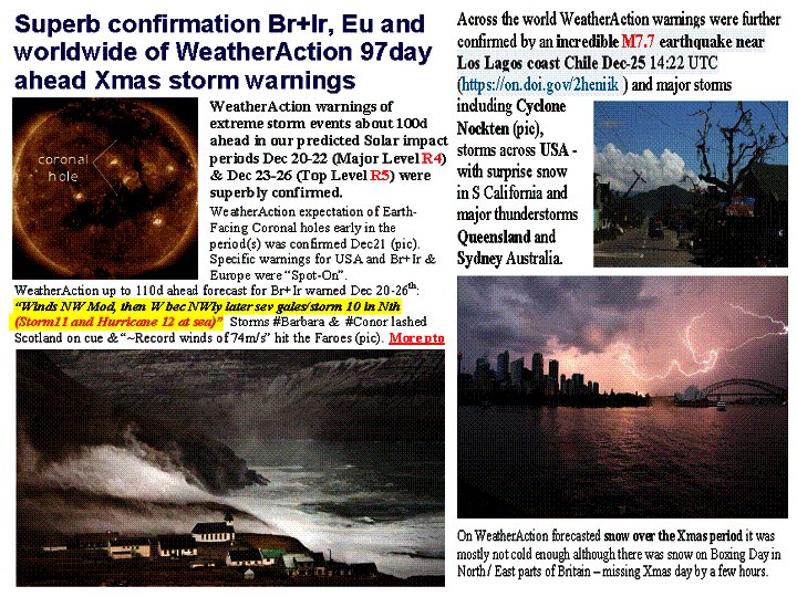
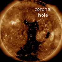 Earth-Facing Coronal Hole Jan3
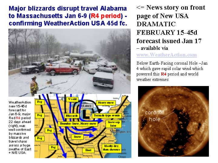
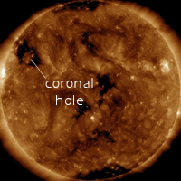
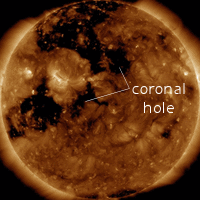
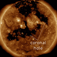
 See Home page re Antarctic Ice extent NOT shrinking


