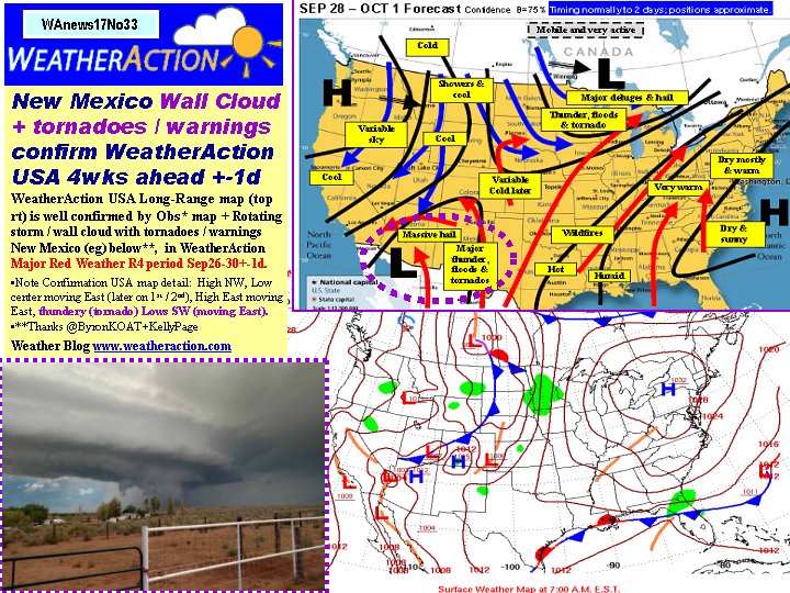
On 20 Feb 2018, @Piers_Corbyn (twitter) London, Chief forecaster wrote:
GREETINGS ALL GO TO NEW BLOG FOR NEW COMMS! See home page for special comments on impending supercold + snow East / South UK especially + NW Eu + Scandinavia =+=+= Prepare for more extremes BI Eu Usa this Spring SUBSCRIBE NOW to our wild Spring forecasts! PASS IT ON! Urgent! Thank you
On 20 Feb 2018, stephen parker ( winter sub ) wrote:
Re David: All models in agreement now, but as you say, by thurs/ fri it will be clearer if its going to happen. It could be a memorable cold spell as its going to hit the south and east hardest, these being the areas least able to cope, an inch of snow that doesn't melt would cause absolute chaos, all schools closed and heathrow shut lol.
I dont know how all the wild animals will cope, the squirrels better stay in their drays!
On 19 Feb 2018, David (Yorkshire) Sub wrote:
I don't think we will know what next week will bring until Thursday Fred. I would say looking, at jet profile it will definitely be blocked and cold for a couple of weeks but maybe not bitterly cold and snowy in UK. Probably 50% chance of that. Which is higher than normal.
On 19 Feb 2018, Paddy, Aberdeen South, sub, 130m elevation wrote:
4˚C at 7.30, overcast, light rain lasting most of the day, occasionally heavy, in a variable breeze which changed from occasional NW to SE, max temp 7˚, also quite foggy from midday onwards, everything dripping wet again, 4˚ at 9.30pm. Everything dripping wet again and as I have mentioned before, the rushes growing in permanent grassland are just everywhere now, feels like its never going to dry up again.
On 19 Feb 2018, Fred wrote:
Piers, I think I read somewhere that you said something about solar/lunar being in very similar set up/state as in 1987? Can you confirm/clarify on this?
Re the period ahead....potential ice days for large parts of the country come 27/28 onwards. Extreme colt backing west
Regards
On 19 Feb 2018, Rohan wrote:
The Evening Standard is saying arctic temperatures over the south east after Wednesday, due to SSW last week. I remember a time when SSW's were not even considered as a cause of temperature/weather changes.
On 19 Feb 2018, Maria (Ireland sub) wrote:
Hey Gerry she is doing really well thanks, an absolute cracking addition to the clan 👌 Totally enjoying the journey & looking forward to lots of weather and cloud watching with her. The only thing is the last 4 weeks I have been prone to losing a week at a time 😊 In the scheme of things we had another light dusting of snow early morn.15th I think if I recall correctly 16th was wet n windy n cold as we were out & about in it followed by an improvement Saturday, showers Sunday and a beautiful almost spring day today with milder temps 12 max today, some cloud moving in here n there this afternoon.
On 19 Feb 2018, Gerry 45d 223ft Surrey-Kent border wrote:
Piers - point taken. Bi-monthly new comments pages? Lots of blue sky and sun over the weekend. To avoid yet another postponed match the local team used an artificial pitch elsewhere. Last home match was played on 13 January. Today started damp and foggy with light rain. Cloud base sitting on top of the 'Walkie Scorchie' and The Shard not visible from the office. After the chilly starts to the weekend it was back to warmer again.
On 19 Feb 2018, eastside wrote:
Coldest week of the year this week in Baltic
Forecast below -20C thursday, & good accumulations of 15-20cm lying snow.
There's good snow cover over most of the Baltic States, & it's currently colder than in Ural region, with anticyclone conditions persist from S of France NE to Scandinavia.
This usually means continuation of cold conditions to the end of Feb in NW Russia/Baltic states/Sweden/Finland.
We do now finally have 10cm sea ice in the Finnish gulf, with sea water at -1, so humidity has dropped through the floor.
The southerly airstream which had been rigidly stuck for weeks has swopped to northerly, which will go round to NE if EU depressions arrive.
That usually means pouring cold air/snow across S+N EU/Alps this week, the moment a pressure drop arrives as it is currently in Italy & deep sub polar lows approaching Scotland.
Oddly,(!)Met France tell a story of near record snow in the Alps this winter, no mention of "climate change"any more+will now be clear & cold
On 18 Feb 2018, Paddy, Aberdeen South, sub, 130m elevation wrote:
-1˚C at 7.30, fairly clear start with some ground frost and a light SWly breeze, but contrary to MO predictions of a sunny day it got cloudy & dull for the rest of the day, max temp 7˚, and by evening we had light rain, 4˚ at 8.30pm.
On 18 Feb 2018, Matt wrote:
Hi Piers, regarding your earthquake prediction theories - my cat, and birds in the garden, went nuts at 2:30 yesterday afternoon for no explicable reason. My wife thought they must have sensed some strange weather phenomenon that we humans couldn't detect. We now realise it exactly coincided with the earthquake in Wales. Here in Sheffield we didn't feel a thing but clearly the animal kingdom did. There is this folk myth about animals detecting earthquakes and that they may detect faint vibrations, or changes to gasses or electrical activity in the air. But from nearly 200 miles from the epicentre? Only the electrical activity theory could be the case from this far away which fits in with your own theory on the solar-charged-particle link. If earthquakes produce some electrical/magnetic change then it would suggest they can also be triggered by it.
On 18 Feb 2018, Ron Greer wrote:
The polar maritime air that has given the Scottish Highlands their high frequency of snow this year has also impacted southern Norway where there is the most snow since 1958. GFS suggests that the easterlies won't really bite until very late in the month and less cold air from the east will follow just a few days later. MWIS and Norwegian Weather Service providing clearer information ( including doubts)
On 17 Feb 2018, Paddy, Aberdeen South, sub, 130m elevation wrote:
2˚C at 7.30, cloudy but again brightening up to a brilliantly sunny day with a max temp of 7˚, light SWly breeze, light frost by evening, 1˚ at 10pm
On 17 Feb 2018, Clive wrote:
The weather patterns at the end of February could like that of February 2005. Checked Netweather charts for February 2005 for details.
On 17 Feb 2018, Ron Greer wrote:
EASTSIDE: I take it you are referring to Rhys' comments?. The Scottish Highlands have had a high frequency of snow since Xmas though not in record amounts, nor accompanied by really severe frost ( just a few days below -10C) STEPHEN PARKER: As recently a 15th Feb GFS and other standard models were juggling and struggling between two sets of outcomes, but now have settled on the easterlies. Almost classic spring weather.
On 17 Feb 2018, David (Yorkshire) Sub wrote:
Stephen - lol I'm not giving you that one. Let's see what unfolds next week. Shots fired by Eastside.
On 17 Feb 2018, stephen parker ( winter sub ) wrote:
Most of the models going for a "beast from the east" from next week end, if even half of it comes off it will be a real shock to us southern softies. and David i did predict this beastie im just a couple of months out lol..
Not to be too melodramatic about it but our busy roads down here will grind to a standstill very quickly , a quarter of an inch of snow soon gets compacted to ice then the fun starts.
As always with our weather we have to wait and see, although in this case we only have a week to wait..
PS. going to whipsnade zoo today in the MGF, might even get some sunshine!
On 17 Feb 2018, eastside wrote:
Where on earth do you get this nonsense from???
You clearly don't live there & haven't been there!
I had to drive through some of the heaviest snow pre christmas in the Jura for decades,-pushing to get my wife to a flight in EXACTLY Geneva airport in Nov through v tough winter conditions.I spent the best skiing conditions of my life in Chamonix, 1-2 weeks before christmas.
I gotta say you are talking utter rubbish!
Snow in the alps has been nr record amounts since mid Dec, with high avalanche risks for hors piste skiing. We have proper winter cold in the Baltic now too.
WHICH PLANET ARE YOU ON?
" Europe was chronically short of snow until Christmas, had a twenty year event in January & February is currently normal with a bit of snow & what Austrians would call 'winterlich kalt' temperatures.
Geneva had the mildest January since records began in the 1860s & the record was broken by a wide margin. Snow at low levels in January was way below average, even if high up plen
On 16 Feb 2018, Paddy, Aberdeen South, sub, 130m elevation wrote:
(15.2.18) 0˚C at 7.30, fairly clear, with clouds racing across the sky from the SW, icy roads as we made our way to the station to travel to Edinburgh where we spent the day. Strong Wly wind whistling through the streets there in brightest sunshine, tourists got a faceful of Scottish weather. 2˚ on our return home after 9pm, no more wind
(16.02.18)
-1˚C at 7.30, cloudy start but brightening up soon enough to leave a mostly sunny day with a max temp of 6˚, light Sly wind, cloudy evening, 3˚ at 10pm.
On 16 Feb 2018, Ron Greer wrote:
The predictive gymnastics of the standard models are almost hilarious in their backtracking and dissembling over the 'Eastie Beastie' Sadly for growers, there might be warmth enough for an early flush followed by a killing frost.
Thinking again about the great frequency of Highland snow this winter, on outbreaks of polar maritime air, it's interesting to compare this with the distribution of ice during the Younger Dryas period ( the last 'real glacial period in the British Isles) and how it might have been brought about.
On 16 Feb 2018, Andy B 45D sub SE Wales wrote:
I agree Gerry this blog is getting a bit out of date and takes far too long to load/refresh especially for people with slow broadband. I think there should be a new blog every month or bi-monthly.
On 16 Feb 2018, @Piers_Corbyn (twitter) London, Chief forecaster wrote:
THANK YOU ALL FOR ONGOING NEWS - superb info! =+=+=+=+= ALL SEE THE EXTENDED OFFER FOR HALF PRICE SPRING - ABOUT TO EXPIRE - HURRY! Overlaps with existing subs get extension forecast credits. =+=+=+= ALL SEE my Home Page comments on StratoWarms (or StratoWaves as I call them now). COMMS WELCOME! =+=+=+=+= GERRY (45d 223ft Surrey-Kent border) the home page does not carry anything about Xmas. You are referring to transferred-over articles from home-page to the Weather blog where the provenance of articles is explained near the start of the page. They have to go somewhere and that is the best place. Newer readers who did not see them on home page may find them useful eg what did we say about Xmas. When we start a new blog those articles stay in thr archive of that blog. Thanks PC
On 15 Feb 2018, Gerry 45d 223ft Surrey-Kent border wrote:
First off - can all the blurb at the top of the page be trimmed as it starts with 'Will it snow at Christmas' and we are well past that? I followed Twitter pages from my home team and the opposition as they would be keen to tell any fans thinking of travelling across Surrey not to bother. Nothing came up so off to the ground and it is in darkness with the gates locked. After getting home a tweet was there saying postponed! Not very 21st century. Dry start to the day with light frost but a band of rain came across and with our ground so saturated - even hoof prints in a field contain water - it was enough to kill off the game. Can't see Saturday's match making it either. Lovely day so far - not a cold start. A shower passed over London during the morning. People are dying in Taiwan as the temps drop to 50F. Yes, doesn't sound cold to us but for them it is and enough to stress the elderly.
On 15 Feb 2018, Ron Greer wrote:
GFS going for a mainly mild rest of the month and nothing from the east until 3rd March.
On 15 Feb 2018, Ron Greer wrote:
Another snow event yesterday up here in Highland Perthshire and probably the snowiest in terms of frequency from Xmas since 2010. Will be interesting to see if the the block appears in the next fortnight.
On 14 Feb 2018, Paddy, Aberdeen South, sub, 130m elevation wrote:
1˚C at 7.30, cloudy but dry with a strong Sly wind which beefed up considerably to gale force gusts through the morning, quite sunny for a time but then the clouds moved in from the W and by 11 it started snowing, still powerful winds, and continued to about 1.30, very wet stuff which readily turned to mush on the ground, max daytime temp 2˚. By late afternoon the wind abated, the rain stopped and it felt slightly milder, 3˚ by 9pm under a partially cloudy sky with most of the snow gone. A real wild one today.
On 14 Feb 2018, mikeb wrote:
Wessex/Mercia borders 600' asl.
@16:05. Rain and strong winds most of the day, 41F ambient temp, but feels colder.
Regards, m (30+45 day)
On 13 Feb 2018, Paddy, Aberdeen South, sub, 130m elevation wrote:
2˚C at 7.30, dry early on but rain starting up by 6 and turning to intermittent sleet in a strong SWly wind, we even had a spell of snow by 11, by which time the wind had also abated, max temp 2˚, brightening up after 2pm & leaving a clear sky for the evening with temps plunging to -3˚ by 9pm. More rain forecast for tomorrow.
On 13 Feb 2018, Rhys Jaggar wrote:
Russ, for a bit of balance about North American snow, go read Tony Crocker's bestsnow.net ongoing review of ski conditions. He has run his blog for over 20 years, gets data straight from resort operators and is a professional statistician.
His report shows SW mountains chronically short of snow, Colorado and Utah average and Northern Rockies slightly above average.
Europe was chronically short of snow until Christmas, had a twenty year event in January and February is currently normal with a bit of snow and what Austrians would call 'winterlich kalt' temperatures. Geneva had the mildest January since records began in the 1860s and the record was broken by a wide margin. Snow at low levels in January was way below average, even if high up plenty exists.
Scotland was struggling until mid January, now it is having four weeks of winter weather. When I lived up there it happened in 1986/7, 1990/91 and 1992/3. 1990/91 was very similar to 2017/18: rain on Hogmanay over tops, then sno
On 13 Feb 2018, Jenny-200 m,outside Inverness wrote:
Awoke to snow falling,with 2 inches of lying snow.Stopped by 09-00. Still lying but slowly melting under the now sun and blue skies. Temp has risen from 0 degrees this morning to 3 degrees.
On 13 Feb 2018, Gerry 45d 223ft Surrey-Kent border wrote:
Windy this morning so no frost to clear. Cold in the wind but at least not as bad as Nunavut in Canada where the schools are closed. Not for a dusting of snow like here but because it is that magic point of -40 degrees, F or C both the same. But the windchill is taking it to -85F or -65C, which is where your skin freezes in minutes. Rain has passed over the City, hopefully not spoiling the pancake races, and it is brighter now. Only around 40F and with the wind, not for the lovers of warmth. Maria - I hope the new arrival is doing well and will come to be a good weather watcher too. The preview of our cup match tomorrow evening is being honest in doubting that it will happen due to the pitch. And it is only just over a month to the season's first ploughing match.
On 13 Feb 2018, Ron Greer wrote:
Another Xmas card scene this morning, then a slow thaw at lower levels. Hills got another addition to the already-long lasting snow pack. Looks like another dose tomorrow. Meteobeeb qyite accurate with this one.
On 13 Feb 2018, Clive wrote:
I have become increasingly sceptical that UK will have many cold winters during the up and coming solar minimum. I do believe that the rest of the world will have colder weather but the UK will miss out most of the time. The reason is that since 2013 the patterns have take a change to increasing the westerlies in the Atlantic as a result of cold in North America that has led to mild and stormy rather that cold for much of the time. I also think the land masses are slightly different to that of the 17th century due to recent continental drift that could make the difference on whether we have milder weather or colder weather in the winter due to the recent drift altering positions of weather patterns. The westerlies have been increasing since the 1980s as a whole in North Western Europe as a whole anyway. The is a lot of data out there I have seen to prove that. Mild winters rather that cold winters may be mostly the case in the future for UK.
On 12 Feb 2018, Maria (Ireland sub) wrote:
Snow turned to wet rain and cleared laying snow yesterday morning. Frost last night with a light covering of snow again by this morn. very light powdery snow. Blue sky and sunshine for a time melting the snow max 7 deg. Yellow wind warning and yellow snow and ice warning issued but then not up on site this eve. Wind and rain this eve. noticed combined of same warning up now on met.ie..
On 12 Feb 2018, Paddy, Aberdeen South, sub, 130m elevation wrote:
-4˚C at 7.30, clear starry beginning to the day, great to see the small sickle of the waning moon low over the horizon in Sagittarius, fairly sunny morning but still blooming cold working in our tunnel filling trays with compost, max temp 3˚ in a gloriously sunny afternoon, light winds W - SW, -1˚ at 9.30pm, apparently were going to get rain & possibly snow tomorrow.
On 12 Feb 2018, Fred wrote:
So a major SSW is now underway, many predicting winter nirvana with massive Northern Blocking and deep winter for N Western Europe . Piers, any thoughts on this?
On 12 Feb 2018, Steve,Dorset, UK sub wrote:
A glorious day yesterday apart from a small snow/hail shower, cold wind after a mildish start, just Finnished washing the car when the snow came only lasted 3mins, so far this winter has been mild from start to end by the look of it arent we lucky down south, hope we get a good summer, fingers crossed if this is global warming bring it on.
Frosty start but now wall to wall sunshine. Cold in the shade no wind today.
On 11 Feb 2018, Andy(Chiltern Hills) wrote:
A few snow showers during the day and a really heavy snow shower this evening giving a slight covering
On 11 Feb 2018, Paddy, Aberdeen South, sub, 130m elevation wrote:
0˚C at 7.30, high cloud, reasonably bright and turning into a very sunny day with a lot of blue sky, albeit with a sharp and cold NWly wind, max temp 3˚ but more like 7˚ in shelter and full sun, -1˚ at 10pm under a clear starry sky, great to have a bit of winter back.
On 11 Feb 2018, Bill S (NE Wales) wrote:
A strong W to NW wind all day , showers of soft hail , hail sleet and snow some lengthy sunny spells early to mid afternoon. The Hail snow showers lying after 5pm as temperatures dropped to around 1c. Some impressive cumulonimbus anvil clouds this afternoon. Looks like another rollercoaster week coming up with some significant snow for Scotland and double digit temps for souther England.
On 11 Feb 2018, Gerry Surrey-Sussex border 223ft 45d wrote:
Wet and miserable yesterday and by 11am the our match was cancelled. Started out cold but then rain came in for most of the day. Dawned sunny - well most likely did as I was asleep at that time. Strong wind from the west making it cold outside. Cloud came over during the afternoon and big sleet shower came along. If there is any more rain I think our cup match on Wednesday will either be postponed or may even be played away.
On 11 Feb 2018, Andy B 45D sub SE Wales wrote:
Bone chilling wind chill here today with snow strong NW wind showers 26mm of rain here so far this month
On 11 Feb 2018, mikeb wrote:
Wessex/Mercia border 600'asl @14:45
Cold sunny day with cold NW wind. Right now its sunny/cloudy/light snow shower/sunny/cloudy/hail shower/sunny!
Regards,m
On 11 Feb 2018, C View wrote:
RON I would concur with your assessment of "a real winter" .Ski areas flush with snow and today parts of the Cairngorm ski area are shut due to the avalanche risk. Pretty amazing since the prophets of doom have been predicting the death of Scottish skiing due to AGW
On 11 Feb 2018, Maria (Ireland sub) wrote:
We had a light covering of snow on the 5th/6th it stayed about in parts mixed in with the frost for a morning or 2 followed by rain. Also a few nice sunny spells here n there during the week though temps stayed on the cool side and cold wet sleety showers never far away.Yesterday a temporary spike to milder temp for a short time followed by a 2nd wet n windy spell and another yellow snow ice warning in place. Fair windy for a time last night after the worst of the rain had moved on there was a starry sky with the wind roaring in the trees, notice the yellow wind and rain warning was taken down at that point only snow warning remained up. Wet snow early hours this morning woke to a very light covering at 6 a.m breezy and snowing now at 11.20 a.m
On 10 Feb 2018, Bill S (NE Wales) wrote:
2300 Tonights Storm in full blast, really howling down the lum. Already gusting up to 80mph in N Wales : - bring on the beast from the east Im fed up of the pest from the west
On 10 Feb 2018, Paddy, Aberdeen South, sub, 130m elevation wrote:
2˚C at 7.30, very windy from SW, frozen ground with rain on top, cloudy morning with rain, brightening up by midday, sunny afternoon, max temp 5˚, rain in the evening, 2˚ at 10pm.
On 10 Feb 2018, Bill S ( NE Wales) wrote:
A topsy turvy week , even today out walking the dog early there was snow flakes in the rain (2c) :- this afternoon its briefly sunny and 11c. A stormy night forecast with snow showers by dawn! This winters not over its certainly different Joe Bs liking the analogue forecast next month to 1958 . As for this winter so far no beast from the east more of a pest from the west ( well north west) . One last thing the Meteobeeb graphics have at least given Scotland a better perspective and for that Im cockahoop long overdue
On 10 Feb 2018, Ron Greer wrote:
M.LEWIS. Just a generic term, So now Metbeeb and as for increased accuracy just look at my last few comments about how things turned out compared to predictions. They're not doing any longer term ones on the scale Piers is doing, are they? None of the predicted snow showers reaching lower ground here, have as yet arrived.
On 10 Feb 2018, Lorraine wrote:
Lorraine//twice the bbc said that the cold and snow has been the best for the Olympic s in South Korea high levels of snow and very low temperatures. Just really makes it perfect for the event how many years previously have we seen artificial snow brought in. The snow has been excellent everywhere long nayxthst last. As for the drought in South Africa hopefully not a recurring theme but hey we had a drought in 1976 so lets hope for rain to fall in Cape Town very soon
On 10 Feb 2018, M Lewis wrote:
Ron Greer. Its no longer the MoBeeb! I reported on here before that the BBC has ended its contract with the Met Office and since the beginning of February has a new contract for weather services with Meteo Group. The weather presenters have all transferred across to Meteo. On News Watch on BBC Breakfast this morning, the BBC Chief Forecaster said that the service provided by Meteo Group is far more precise and accurate. Comments please Piers et al!
On 10 Feb 2018, Ron Greer wrote:
Overnight Fri/Sat snowfall not as heavy as standard models predicted and nothing much below 200 metres. Skies look ominous though.
On 10 Feb 2018, Sou'wester (Cornish border, sub) wrote:
Today's Daily Mail carries an article summarizing a UCSD study on the coming mini ice age, saying they've predicted a Maunder minimum occurring by about 2050, calling this a grand minimum, because they say it could be worse than when the Thames froze over in the 17thC. Nevertheless, they say that this event is unlikely to stop the effects of "climate change" and is only likely to slow down "global warming"......I expect that they wouldn't have been funded/published if they hadn't said that latter, but look at the contradiction.
On 10 Feb 2018, eastside wrote:
Noted, chicago / detroit snowed up, pretty much as predicted, more to come...
France coldest nights this winter.
Most of central Europe under an easterly airflow giving freezing temps.
Ural now down at -20C> again..
Baltic states/SPB region, good snow cover, coldest temps this winter, (but not deep cold).
Alps, some of the heaviest snow cover in 10 years and longest stretch of high quality ski in a decade.
repeated snow episodes in north Africa....
Looking good for the "our children won't know what snow is" claims.
On 09 Feb 2018, Ron Greer wrote:
Mobeeb, now ramping up snow event in Scottish Central Belt and Borders for Saturday night--not going away as quickly as first thought
On 09 Feb 2018, Paddy, Aberdeen South, sub, 130m elevation wrote:
0˚C at 7.30, cloudy but not feeling cold in the light NW breeze which later picked up a bit, brightening up by 10am and giving us a beautiful sunny day with a max temp of 3˚, clear evening with -3˚ at 10pm. Im very happy that today I managed to see and photograph a Kelvin-Helmholtz cloud formation, a series of about 25 curls like the stylised waves of the ancient greeks, not as perfect as in the pics you can find online but it was real and on our doorstep.
On 09 Feb 2018, Ron Greer wrote:
Current run of GFS suggests multiple opportunities for snowfall over most parts of the British Isles
On 09 Feb 2018, Gerry 45d 223ft Surrey-Kent border wrote:
It continued warming all day yesterday and brought rain overnight and into the morning. Just what we didn't need as all the lakes on the roads are back and I am concerned about our pitch for the coming home games. The boys haven't played at home for ages and promotion is at stake. They did play at 'home' borrowing a 4G pitch to get a game played. Shame after all those dry days but maybe if it doesn't rain any further... Lots of heavy snow across the NH which is of course at odds with the claimed warming. The UAH has shown temps dropping sharply so we shall see what comes next.
On 09 Feb 2018, Ron Greer wrote:
Last night's front went through with no significant snow below 200 metres. Nice late winter's day now with blue skies and white hills and just a touch of frost. A real winter since Xmas, but not an especially severe one.
On 08 Feb 2018, Paddy, Aberdeen South, sub, 130m elevation wrote:
3˚C at 7.30, cloudy, less cold, SWly breeze with occasional gusts, brightening up after midday, max temp 6˚, great sunny afternoon, stars out by evening with some clouds drifting across, 2˚ at 9pm. The little snow we had left has all gone but I doubt this was the end of it. == Russ, regarding bad summers, its taken me some time to adjust to making sure we sow our veg early enough, but not too early of course or they get hammered by late cold, there used to be plenty of time in the spring to get going but now Ive learned that if you dont anticipate every summer as bad you invariably get caught out, 2013 was the last really good summer here after the really cold, wet & dark one of 2012.
On 08 Feb 2018, mikeb wrote:
Wessex/Mercia border 600'asl
Wet windy 44F
Regards,
m (30+45day)
On 08 Feb 2018, Richrd wrote:
Well, we had the joint coldest night of the winter in S Cambs, snow bereft E Anglia region, got down to -2 deg (wouldn't want to be a de-icer/sledge sales man here). Remarkable how little cold we have had, cooler winter than the last several for sure, just above average temps, despite all the hoohaa over freezing temps and snow in the papers. Depending on which side of the fence you sit, it could be said that equally that we have our heads in the sand over global warming, surely the average and temp trends are the best measure?, records are broken all the time, warm and cold, but that depends on whether you have faith in the data of course!
On 08 Feb 2018, Ron Greer wrote:
RUSS: Yes, you are correct about the snow. A front-wheel drive car with snow/winter tyres is a big help if you can;t afford a big SUV. Some felt-pack boots with gripper galoshes are god for your own feet too. And stock up with basic essentials if there's a long walk to the shop. Also store dried and tinned food in case there's power cuts and your freezer packs in.
On 08 Feb 2018, Russ Derbyshire wrote:
There's much ignorance about the disruption a couple of inches of snow can cause. I've laughed at the news articles about schools closing along with everyone else, but the snow we had a week or so back made me realise that maybe my laughter was premature...or should that be immature? We live on a hill and tried to drive to the shops before the snow got too bad. Came on suddenly so time was short. Fat, wet flakes so I was dubious about trying. Traction almost nil and we struggled to get 500 metres back home. We now have an SUV because the only cars we saw that were coping were these behemoths. Every Merc, Audi and hatchback we saw was stuck and in a spot of bother, sliding all over the place trying to get traction. All this with just 2 inches of fresh wet snow. So don't jump to conclusions folks. That 2 inches of snow can be a whole lot more troublesome than you might imagine.
On 08 Feb 2018, Russ Derbyshire wrote:
Record this and record that. Those records just keep coming. The list of disruptive snow events on Mr Felix' site I expected around 2019-2020, nearer solar minimum. Its starting early. I suppose the previous civilisations that were caught with their heads in the sand when they suddenly found themselves with crop failures for 3 or 4 years running, didn't notice anything in particular about their weather. Maybe its just another bad summer huh? Maybe its just another snowy winter. This bad weather never lasts more than a few years then its back to bumper harvests. Then they all got wiped out in a matter of decades. I notice that many people pooh pooh the theory of a rapid onset ice age. Plenty of sand for those heads to bury themselves in but mother nature will have her day! And words will be eaten! Its not a matter of if but when. Mini ice ages start quickly so we won't know for sure if its the start of the big one until its too late. I'd love to see the realisation on those sandy faces!
On 08 Feb 2018, Gerry 45d 223ft Surrey-Kent border wrote:
Tuesday in London didn't make it over 40F all day and it was a freezing evening to watch football near Gatwick but a win was good. Managed 41F yesterday afternoon but from a really cold start today - reading 25F on phone at wake up time 6.45am - it is now 45F in London after a sunny day so far. At least this dry spell is helping the ground to become less saturated and I hope we can have matches at the local ground again as the boys are at home Saturday and then a cup match on Wednesday night. Lots of snow disruption in N France and Paris, and more snow around Spain. After the coldest superbowl ever the Olympics are being held in record cold as well.
On 08 Feb 2018, Ron Greer wrote:
GFS now backtracking on easterlies from 20-23rd, but suggests a major blizzard event, especially for Scotland on 14-15th. Thereafter mixture of mild and cold spells with other snow events possible from polar-maritime outbreaks
On 07 Feb 2018, Paddy, Aberdeen South, sub, 130m elevation wrote:
-3˚C at 7.30, clear moonlit start followed by a sunny & cold morning with the breeze backing from W to SW and picking up by midday, when it also turned cloudy from the W, producing the odd snowflake. Max temp 2˚, strong breeze by evening, 1˚ by 9.30pm.
On 07 Feb 2018, Ron Greer wrote:
Another double-digit frost last night and light snow from late morning, though not adding much to the remaining lying snow. Continuing to find MWIS the best of the standard models with Simian Foot-painters splatting around quite a bit.
On 07 Feb 2018, mikeb wrote:
Wessex/Mercia borders 600'asl
Light snow fall yesterday evening, no covering. Temps 32-34F
Light frost this morning temps still just above freezing, sunny earlier now light o/cast.
Regards
m (30+45day)
On 07 Feb 2018, Mike wrote:
David: That was my thoughts. Which could make Final third of forecast irrelevant. Would Piers consider altering the forecast??
On 07 Feb 2018, David (Yorkshire) Sub wrote:
Craig - Yes there has been the North/South split as expected. Mike- Piers normally includes expected dates for SSW, so I presume it was not anticipated or surely it would have been given a mention.
On 07 Feb 2018, Mike wrote:
Hi Piers
When producing the Feb forecast. Was the expected SSW taken into consideration?? If not and the SSW happens as forecasted by many models. Will this alter your Feb forecast??
Could you share your thoughts please.
Kind regards
Mike (30 Day subscriber)
On 07 Feb 2018, eastside wrote:
Looks like I made a good call on France this week.
Snow everywhere, chaos everywhere.
A total joke how one of the world's much vaunted "most advanced economies", falls apart with a few cms of snow.
Macron & Royale, they went strangely silent on their "global warming" mantra now.
The cold reaches a peak the end of this week in the Baltic here.
forecast -16C & the snow will stop, after more or less continuous for 48h. (We now have about 10-12")
It will then warm up quite a bit, & sun come out.
Sea is now freezing, but this is not the really harsh cold of a proper winter, when they open the famous ice roads.
So, a mid month freeze up? Valentine day special?
Nah I don't see it.
Lots of humidity is circulating around west-east so back to rain for France next week-a general thaw, while Scandinavia keeps some blocking high pressure/high over Azores pushing the humid air off the atlantic back into land as snow in central Europe.
Now to get out the snow shovel again...
On 07 Feb 2018, @CraigM350, Sub Berks 51N wrote:
I weren't for a cold Spring back in October and I think David did at the same time. It looks a good call. The last tone we had a SSW was 2013 which was in the Jan and led to the prolonged cold spring. That was an early Easter - I.e. set around the phase of the moon - as is this year. We might get some late winter warmth but I doubt it will last as spring approaches. I do see further snow as it's the kind of winter that hasn't made up it's mind and ominously the late record snow in Moscow portends the late build up of cold on or side of the the vast Eurasian continent. All in all we've done fairly well from a NW flow for the past couple of months. No beast in sight yet but that could change later. It's been 9 years since a decent Feb cold spell (lunar?). It's overdue.
On 07 Feb 2018, @CraigM350, Sub Berks 51N wrote:
A few snow flurries this evening and a light coating settled on cars. Dew points have been below zero for the last day our so, temps max 4°C with min hovering around zero. Dew points have been zero or below since the last day of Jan. Whilst this cold spell had not been anything special kudos to Piersv for picking it out from so many months ago. It has not been a memorable winter so far but it has been snowy. 4 times snow has settled, 2 with a cm or more and the mid Dec measured in inches. I think it's snowed 6 times in total with plentiful frost. Cold and wet describes it fairly well with a fair amount of mobility. I'm sort of glad we've escaped-as much as I love snow the chaos I don't when I need to travel. We now seem on the cusp of change with a predicted SSW imminent. It looks favorable for cold but as ever is a lottery slightly in our favor (2/3 for cold I believe). I wonder if this could be one of those periods that go either way. Cold nirvana or spring.
On 06 Feb 2018, Andy(Chiltern Hills) wrote:
A covering of snow in the Chilterns tonight and still snowing although fairly light
On 06 Feb 2018, Paddy, Aberdeen South, sub, 130m elevation wrote:
1˚, snow, not very much of it and of the wet kind, persisting on our hill all day but below us there wasnt much of it sticking and all gone by end of morning (unlike Paris, where there is traffic chaos tonight, as we hear from friends & relatives). Max temp 2˚ in a Wly breeze at first, turning into the NW later, cloudy morning, brighter afternoon, clear evening, -2˚ by 10pm.
On 06 Feb 2018, Fred wrote:
David - I have my reservations BUT a Scandinavian block is anticipated to form around midmonth. The talk is that the troposphere response is anticipated to be quite rapid so last week of Feb might be in play. The teleconnection charts are apparently edging off the scale so interesting indeed. Midmonth R4 period for Piers, also B and C class flares emanating from the current sunspot...which is unusual for approach to solar minima.
On 06 Feb 2018, Ron Greer wrote:
Mobeeb going for a generally cold outlook with intermittent milder spells. GFS run at 22nd Feb suggest cold easterlies.. You might be right about March-April, David. Beeb also predicting -11C tonight---might be colder than that on the ground.
On 06 Feb 2018, Ron Greer wrote:
another Xmas card scene this morning, but now sunny and quite pleasant.. Been a real, but not generally a severe one apart from a handful of nights with double digit frosts. Might be another one tonight,
On 06 Feb 2018, David (Yorkshire) wrote:
Fred - if it has any implications on our weather, i would expect it to be in March/April. Which ties in with my musings before Xmas about a blocked spring Month. I cannot see it putting us into winter wonderland in February. had about 3 flakes of snow from this cold snap.
On 05 Feb 2018, Paddy, Aberdeen South wrote:
1˚C at 7.30, cloudy with the moon putting in an occasional appearance, cloudy all day with a max temp of 2˚, occasional drizzle & mostly Sly breeze, -2˚ by 10pm. Snow forecast overnight, looking at the radar picture it might not amount to much, but I could be wrong, certainly yellow warning on MO.
On 05 Feb 2018, Maria (Ireland sub) wrote:
-3 this morning frost and ice clearing late morn. Remained cold all day, light snow started around 9 pm / maybe lil bit earlier :) Well done Piers called it again 👍
On 05 Feb 2018, Fred wrote:
Piers
What is your take on the hugely hyped forthcoming predicted SSW for mid Feb? Is it hype? Major height rises being forecast for Scandinavia and a tanking into neg territory for the AO.
Scandinavia block looks a real option....but positioning is crucial. Your thoughts?
On 05 Feb 2018, Steve Devine wrote:
Hi Piers, just wondered when the 100d ahead March forecast will be released please? Many thanks, Steve.
On 05 Feb 2018, Gerry 45d 223ft Surrey-Kent border wrote:
Snow! Temp at alarm was 34F I having seen the moon out I thinking I should have covered the windscreen. Not much white frost around and neighbour's flag flying in the breeze so probably too windy. Then spotted flakes while in the kitchen. Come drive to station, it was snowing strongly and settling. Thin layer of ice on the windscreen. Heading up the line approaching Croydon it was blue sky and hardly a trace of snow on the ground. On arrival at Cannon Street it snowed a tiny bit but has mainly been blue sky and come 2pm is 41F. Moscow has had heaviest snow evah, and that was in a BBC report, which then drivelled on about Russians glad to have a real winter after all the recent hot ones.
On 05 Feb 2018, Clive wrote:
We sometimes get a period of winters were the cold is early like that of 2008 to 2011 or 1976 to 1982 but we can get a period like that of 1967 to 1970 or 1984 to 1987 were the cold is late. What makes the winter cold come early or late. We seem to have clusters of similar winters at a give time.
On 05 Feb 2018, Clive wrote:
Does Kent get a Dangler like that of Pembrokeshire? Kent seems to get snow but other places like London missing it and Pembrokeshire gets snow and places like Swansea missing it.
On 05 Feb 2018, @piers_corbyn wrote:
RON, ANDYB, ALL; LOOK AT THE SNOW AND TELL ALL WeatherAction issued the first forecasts for this 4 moths ahead and it's time for them to SUBSCRIBE! {RON}On forecasts categories etc: All weatheraction forecasts [except specific one-offs such as sudden stratosperic warnings and tropical storms /Typhoons] ARE MONTHLY ie they are about calender months. The 45d eg is shorthand for 15-45d eg March 45d is for the month of March and is available from Mid Feb. 100d forecasts are for the season/ quarterly forecasts some want eg 100d issued 22 nov is for the 3 winter months together and available 10 days prior ie is 10 to 100d it is also same as Feb 100d meaning litterally 70 to 100d because we normally also provide all forecasts up to the month specified. On order of issue (AndyB) for various reasons Europe can be checked in desk top form quickest and so it makes sense to issue it first; but more specifically issuing in order of time Zones makes sense for forecast users ie Eu, Br+Ir, Usa. Thanks
On 04 Feb 2018, Paddy, Aberdeen South wrote:
(03.02.18) -1˚C at 7.30, cloudy & grey, travelling up to Nairn the rain started at Huntly and never stopped until early evening, temps varied between 0.5 - 3.5˚ depending on location.
(04.02.18) Back down home from cloudy Nairn, the hills north of the Moray & Cromarty Firth were well covered in snow, sun coming out after midday around Keith, max temp 5˚C on the road, same at home apparently where it had been 0˚ in the morning, (theyd had no rain on Saturday), -1˚ at 10pm under a mostly clear sky.
On 04 Feb 2018, Maria (Ireland sub) wrote:
A mixed bag so far this month, sleet hail rain and some dry sunny spells too. This morning was cold a little frost about but sunny and late morning was nicer for getting back out walking and some fresh air for all. Max 6 deg 2 now at 10pm Yellow snow ice and low temp warning for Mon.night.
On 04 Feb 2018, Istvan Ilyes non sub CrawleyWest Sussex wrote:
Please read weather forecast in the daily star.
On 04 Feb 2018, Gerry Surrey-Sussex border 223ft 45d wrote:
Another day of rain to top up roadside lakes and cancel our local team's footie match. Hope away pitch less soggy for cup game on Tuesday. Chilly yesterday and cold today with some sunshine. Cloudy with sunny spells later. Spain has had some nice snow and fans are warned to take precautions at the Superbowl this evening as it will be coldest ever with temps down to single digit F.
On 04 Feb 2018, eastside wrote:
Looks like the coldest week of the winter is coming up here.
This is strange, because it's traditionally 4 weeks ago.
It's several years now, the normal "seasons" are shifted a month later. It was the same last year, with a very late spring and no summer heat until right at the end just before september.
France just had a stupidly mild-wet January, more typical of October-November.
Now, the classic scenario of a high pressure over Scandinavia is in place.
Already the NE wind is blowing to a gale today, after flat calm for a few days.A low heads out across Poland towards Moscow.
This NE stream will freeze all the Baltic states then Poland.
The frigid air is then going to be pouring back across Europe over the next days, so don't be disappointed, the usual chaos will ensue in western Europe.
It's all just a bit later than expected.
On 04 Feb 2018, Ron Greer wrote:
Interesting dichotomy in the January temperature data with Scotland, northern England and N.Ireland being colder than average and, as our commentators have told us, above average in the SE of England. Looks though as if this latter part will get something a little chillier this week, but not exactly severely frigid. Solid snow-pack has built up on Highland hills.
On 03 Feb 2018, Richard wrote:
I think your right, over hyped by media me thinks (BIG FREEZE Snow BOMB) etc sells lots of newspapers but not very accurate truly fake news! Will be more of a fizzle than a freeze, me thinks East Anglia will remain bereft of snow and not all that cold-, perhaps match record of -3 so far this winter at night- we still have mossies in the garden- tells you how cold its been so far this year.
On 03 Feb 2018, David (Yorkshire) Sub wrote:
I think the media and certain forecasts/websites are over hyping next week. Yes it will be cold and I'm sure it will snow a bit in places but it does not look like a classic cold spell/big freeze to me. Happy to be proved wrong.
On 03 Feb 2018, Ron Greer wrote:
Yet another Xmas card scene this morning, but snow easing off now. Griiter trucks ( aka the rust lorry) heading up the A9.
On 02 Feb 2018, Paddy, Aberdeen South wrote:
2˚C at 7.30, still showery with clear spells in between, dry by mid morning and quite sunny for the whole day, max temp 5˚, much lighter NWly wind, moon lighting the evening through the clouds, 1˚ by 10pm with a light frost. == Bill S, it doesnt take too much for the C to T road to be closed and is not always followed by snow for us nearer the N Sea, but knowing what we know
On 02 Feb 2018, Bill S (NE Wales) wrote:
All quiet today in this ridge of hp. Plenty sunshine and light NW wind max 7c. A good walking day .Snowdrops and crocus out, daffodils making good headway at 4 tall probably with all the recent mild weather. I heard on radio Scotland the Cockbridge to Tomintoul road was closed this morning due to snow.Is this an early indication of the conditions for next week?
On 02 Feb 2018, Gerry 45d 223ft Surrey-Kent border wrote:
Some spots of rain last night and patchy cloud but come morning it was 40F so between recent highs and lows. Some cloud and too warm for frost which was good. No windscreen scraping and as many of my country roads still have large pools of water, no ice on the untreated roads. Sunny in London and 45F in the early afternoon. If anyone has some spare change, Professor Peter Ridd is raising money to fight the James Cook University who are trying to gag him form telling the truth about corruption of science in institutions. JCU have form in behaving like the Stasi as they treated Bjorn Lomborg the same when he dared to stray from the message and tell the truth. Following the death of Carillion, a contractor building windmills had to tell the market it was £80m overspent on the project. Have these projects been underbid and is a new can of worms about to open?
On 01 Feb 2018, Bill S (NE Wales) wrote:
As an alternative to the previously reported mid week storms this month, this Wednesday was much quieter ,although it was quite breezy with a rare thunder and lightning shower around 0400hrs this morning (Thurs). This was preceded by some sporadic large hail hail followed by heavy rain in the shower. Still breezy today much colder but only rain showers.
On 01 Feb 2018, Paddy, Aberdeen South wrote:
2˚C at 7.30, rain on a strong NWly wind, turning into a wild day with frequent showers and gale force gusts, max temp 4˚ and actually staying there right into the evening as at 9pm, by which time the wind also lost some of its strength and it almost feels mild out. == Lorraine, that is remarkable testimony from the Inuit, I should pay more attention to sunsets since I spend a lot of time out of doors.
On 01 Feb 2018, stephen parker ( winter sub ) wrote:
Models now going for a below average February temp wise, with a ssw event mid month. South and south east may see some snow next week and very cold days.
On 01 Feb 2018, Gerry 45d 223ft Surrey-Kent border wrote:
Seems my post yesterday didn't come through due to internet problems. I pointed out that yesterday morning it was 46F, up 16 degrees on the previous morning and today we are back down again as it was 37F. The suggestion is it might be cold tomorrow so 2 cold mornings in a row! No frost but there was ice around. Nice and sunny though. The SE usually gets it worst snow when it drives in from the east or NE. We can get some from the SW but north and NW systems rarely reach us with snow. Reading South East Farmer, Southern Water have asked for an extended extraction licence as their main reservoir is only half full!! That seems strange given the sodden fields and frequently full watercourses. A blizzard for the mountains in Tasmania, and yes it is summer there. In fact they had hot temps just before. Over the Bass Strait, if you live in South Australia or Victoria, access to free wind and solar energy has doubled your electricity bill in just one year. How strange.
On 01 Feb 2018, Ron Greer wrote:
BEN FARRINGTON: Aye the frequency of the incursions of NW winds bringing polar maritime air has given those who live in the Scottish Highlands something of a winter this year with heavy snow and double digit frosts at times. However for those SE of the famous Tees-Exe line it has been a snow-bereft winter for cold lovers. Though it may change a bit this weekend. It is easterly winds that bring cold snowy weather to that part of Britain and they have been generally lacking so far, as we enter the last month of the meteorological winter.
On 01 Feb 2018, stephen parker ( winter sub ) wrote:
Models now going for some cold next week in the south, maybe a sting in the tail this winter?
On 01 Feb 2018, stephen parker ( winter sub ) wrote:
Down here in southwest Hertfordshire, none of this winters major snow/blizzard polar vortex type of events forecast have materialized, its been very dull and damp!.Im looking forward to spring now to dry everything out.All the lakes and rivers are full so hopefully no idiots fear mongering about drought this year. The next couple of winters are important for the followers of the low sun spot/ solar minimum causes a mini ice age camp, although North America might say they've already had it!
On 31 Jan 2018, Lorraine wrote:
https://youtu.be/dR7IlDKzd90
Lorraine// ok today I think it was the Daily Mail there was an article on an impending polar shift. Apparently a Danish study is saying that this is the reason for climate change although I did some dowsing which said both were contributing but only a small percentage of human. Even so zero contribution to upsetting the equilibrium of our delicate systems has to be considered. However this article once again brings me to the Innuit Indians you tube video on their firm belief and actual proof the Sun has shifted or the earth has shifted. Why isnt science taking this seriously. There fishing markers of sun and stars are not in the same place. I can identify with them as when you are brought up in the countryside or wilderness you notice where the sun rises and where it goes down. Maybe its more noticeable in the northern extremes but I do think something has happened there has been a shift. The sun definitely has more strength in the summer for longer.
On 31 Jan 2018, Paddy, Aberdeen South wrote:
0˚C at 7.30, full moon lighting up the westerns sky earlier on, light Wly wind all day, so very pleasant in the sunshine with a max temp of 5˚, clouding over mid afternoon with the air smelling a bit like rain or snow coming but so far it has stayed W of us in spite of yellow warning by MO from last night, well see what we wake up to in the morning. Still cloud cover at 10pm, hence 4˚.
On 31 Jan 2018, Maria (Ireland sub) wrote:
Met.ie had yellow wind warning and snow and ice warning for more N counties last night. Here we have had a mix of rain sleet wet snow and windy for a time. 3 deg. feeling cooler at 9.13pm..Thanks Sou'Wester :)
On 31 Jan 2018, Ben Farrington wrote:
Cold blast arrived today, whilst working on the Lairig Gartain path between Glencoe and Glen Etive 350m asl, about 3 or 4 inches more in the drifts. nothing below 200m. But by a long way the snowiest week this month was from the 15th to the 21st ( west highland region) It snowed every day with a foot or more of snow on Rannoch moor. One of the coldest days was around the 7th and 8th, well below freezing leading to partial permafrost forming on the Lairig Gartain path. Broadly speaking the WA January forecast was good, BUT the details were lacking in terms of severity at times and conversely at other times not as bad as forecast. I'm not sure why people are so concerned with the beast from the east, its the ? from the north west that has brought copious amounts of snow to SW Scotland through to the NW highlands.
On 31 Jan 2018, Ron Greer(subs) wrote:
Woke up to another Xmas card scene this morning. Impressions of quite a snowy winter since end of December and the first time I've had frozen pipes since 2010-11. Mobeeb now, of course, backing off HP over Scandinavia and going for a HP to the SW with a NW'ly flow. Beast cancelled yet again
On 31 Jan 2018, Steve Devine wrote:
January daytime temps averaged 7.7c in SW Essex and 4.2c by night. That's 1.6c milder than Jan 2017 by day and 2.6c milder at night, but still cooler than Jan 2016 which was the super mild El Nino winter of course. Computer models all over the place. Some place High pressure to our NE over Scandinavia while the GFS gives us a virtually continuous NW'ly flow until mid Feb.
On 30 Jan 2018, Paddy, Aberdeen South wrote:
1˚C at 7.30, cloudy with a stiff & cold SWly wind which lasted all day, a bit of sunshine in the morning but otherwise pretty grey, max temp 5˚, down to 4˚ by 9.30pm. Snowdrops have their little white bells now, seems to me somewhat earlier than usual. == On an unrelated matter: we have not been able to send/receive GMail emails for the last couple of days, anyone in the same boat?
On 30 Jan 2018, Richard wrote:
Would put money Ron on Low pressure, mild from SW rather than Cold weather playing out from east (or North for that matter), as per last few years generally, I can just about remember what a beast from the East is but the memory is fading.
On 30 Jan 2018, Gerry 45d 223ft Surrey-Kent border wrote:
Moving on 24 hours and this morning the phone said 30F - so 20F colder than yesterday morning. With the moon out I expected a frost. Moving into the afternoon it is 48F in London. At least it is sunny and dry.
On 30 Jan 2018, Ron Greer(subscriber) wrote:
Latest week-ahead from Mobeeb has now been updated after less than a week of course. Now, later into next week postulating two different HP scenarios giving us a choice of cold polar maritime air or even colder polar continental air. Any bets that it will turn out to be mild SW winds and low pressure instead?
On 30 Jan 2018, Sou'wester (Cornish/Devon border, sub) wrote:
Forgot to add below that it was blowing up a hoolie most of yesterday until very late afternoon. Sea was too rough for local boats to go out, and the rain was torrential for brief periods. Today however, at 10:15, things have changed. Still quite chilly, but fog has lifted to reveal hazy sunshine, and only a Force 1 wind (light air), with the now sea slight.
On 30 Jan 2018, Sou'wester(Cornish/Devon border, sub) wrote:
David (Yorkshire) well we have had the frosts down here. Stepped out at .6:50 yesterday and this morning with a hard frost on the ground - but a low-lying fog seems to have cleared it by 09:15 or so both days. Was walking - carefully (!) - through the frost and mist, down a lane, and spotted an almost purely white female pheasant about 50 yards away, half-visible through the fogginess, making her way into the distance. Magic. Not so magic when I arrived at my office and read the thermometer inside - 40F. Maria, belated congratulations on your little winter wonder.
On 29 Jan 2018, Paddy, Aberdeen South wrote:
3˚C at 7.30, starry beginning earlier on even though there was quite a bit of rain overnight, sharp & cold Wly wind but overall a great sunny day with a max temp of 5˚, no frost yet but 2˚ by 9.30pm.
On 29 Jan 2018, Maria ( Ireland sub ) wrote:
Yesterday was grey overcast with showers and a little windy, 9 to 10 deg turning a bit colder after nightfall around 5 deg. Max 8 or 9 today 3 deg. Now at 8.40pm Some nice sunny spells amongst the clouds today..
On 29 Jan 2018, Gerry 45d 223ft Surrey-Kent border wrote:
Grey start to the day but warm. Phone showed 50F at 6.45 and now 55F in London. At least it has been dry over the weekend and the floods have gone from the roads. Lots of snow around the N Hemisphere and a record low in Bangladesh. Meanwhile, Down Under they have been showing us our energy future as Melbourne suffers blackouts due to aircon units being switched on. Politicians wriggling on the hook to blame anyone but themselves. Could be us as soon as next year.
On 29 Jan 2018, Ron Greer(subscriber) wrote:
Mobeeb week ahead on Mon 29th Jan, now going for a generally cold week based on frequent incursions of polar maritime air with intermittent intrusions of milder SW winds. However they are also postulating at the end of the period a HP building over SW Norway with an easterly developing. The snow-bereft in Norfolk may get their wish.
On 29 Jan 2018, David (Yorkshire) Sub wrote:
No polar vortex event and pretty mild and wet.
On 29 Jan 2018, Gerry Surrey-Sussex border 223ft 45d wrote:
Alistair - It is not irony but hypocrisy. Standard practice for Marxists like McConnell.
On 28 Jan 2018, Paddy, Aberdeen South wrote:
5˚C at 7.30, light SWly breeze, sunny morning with temps slowly rising to a max of 8˚ by afternoon, by which time it had clouded over and we had some light rain for the rest of the day and it got even warmer: 9˚ by 9.30pm. Although winter is by no means over, there is a change in the air from December, on warm days like this our corn salad/lambs lettuce puts on a bit of growth, as I noticed today compared to the last picking, one can also see shiny new blades of grass. But I've lived up here long enough not to get any funny ideas about an early spring :-)
On 27 Jan 2018, Paddy, Aberdeen South wrote:
5˚C at 7.30, drizzle & grey all morning, sun coming out though around 1pm, at the same time as an increasing SWly wind that got quite strong by evening and turning a bit more into the W, max temp here was 9˚ but in town it was 12.5˚ according to the car thermometer, still windy at 9.30pm with 6˚.
On 27 Jan 2018, Ron Greer(subscriber) wrote:
Mobeeb/ Meteobeeb, or whatever is going for an oscillating mild/cold spell regime based on the Jetstream behaviour for the next week. Some other models going for an easterly component later. The GFS will of course be as 'reliable' as ever at 4 hours notice. Finding MWIS the best of the standard model presentations.
On 27 Jan 2018, Ron Greer(subscriber) wrote:
PIERS: I agree with David's points. Please rationalise your forecasts to calendar months and multiples thereof. Quarterly periods covering the meteorological ones Dec-Feb, March-May, June-Aug, Sept -Nov,( to replace 100-day ones) with options for multiples of these too and please can we have the calendar month ones available on the 1st of each month and not well into the first week?
On 27 Jan 2018, Maria (Ireland sub) wrote:
Managed to get home Tues. a day early was great to see daylight again :) Cheers Paddy Gerry n Dave for congrats.... We had Orange warning and storm G which although very wet n windy didn't seem too bad here. Thurs and Fri some nice sunny spells dry and mildish after cool starts, all change again today overcast breezy with showers continuing from overnight, 9deg at 10 a.m
On 27 Jan 2018, M Lewis wrote:
I see that the BBC has switched its weather forecast service from the Met Office to MeteoGroup.
https://www.meteogroup.com/about-meteogroup
What does Piers think about that?
On 27 Jan 2018, eastside wrote:
Contradiction is the sign of the global warming mob..
The 2017-8 Paris mob is not much different from their post 1789 revolution fervour for pointlessly beheading 1000s of innocent people, then going on a Napoleonic rampage across Europe.
"Mayor of Paris Anne Hidalgo said the city was coping - but said that the flooding, coupled with recent summer heatwaves, was "clearly a question of the town adapting to climate change"..
..whereas in exactly the same biased BBC article..
"The statue of a Crimean soldier - known as the Zouave - on the Pont de l'Alma has long been used as a marker for water levels in the city.
On Friday, the water was at its mid-thigh - not as high as the 1910 floods, which reached his neck & submerged the city for two months."
So 100 years later a 2m smaller flood than 1910, is now due to "climate change", despite the fact most major EU cities no longer have smog & coal related pollution or world wars!
WTF?
What sort of idiots do these people th
On 27 Jan 2018, David (Yorkshire) Sub wrote:
Piers I have seen that but I am sure 45 day forecasts are more detailed than that mid month for the following Month? Furthermore I sent you an Email query(admittedly) prior to finding the short summary in my subscription box and did not get a response. This was sent on the 21.01.2018. Too many options on offer and cross over time periods, as previously mentioned by others. These then get superceded by sales every Month to add to the confusion. So there's is nothing up Piers. I attempted to address this privately. Thanks
On 27 Jan 2018, @Piers_Corbyn (twitter) London, Chief forecaster wrote:
GREAT OBS ALL, KEEP IT UP! THANKS! More exciting times ahead - predicted to WeatherAction subscribers 4mths ago +=+=+ DAVID (Yorks), FRED (+ maybe other 45d'ers etc), WHAT'S UP? YOU HAVE BI 45d (or Eu 45d or Usa 45d). It is, as stated, a COPY of All-winter(Feb) issued 26Sept (Oct1 Usa). IT IS POSTED MARKED AS COPY IN YOUR 45d box(es). There are NOT extra copy postings in 75d, 100d, 5m, EuEnergy or All-winter boxes because the latest Feb forecasts (at this moment) are already there as in All-winter. If you missed it because you only looked in your 30d box (which comes before the 45d box) please note in the forecast access process it clearly states in large highlights:- "IF YOU SUBSCRIBE TO MORE THAN ONE SERVICE, or cannot see your service, SCROLL DOWN Forecasts page to find Access to sections for other services." The essential points of Feb which that forecast gives have not changed and 4mths ahead are more detailed than standard forecast which have been getting hints a week ahead.
On 26 Jan 2018, Paddy, Aberdeen South wrote:
1˚C at 7.30, fairly clear start and staying a mixture of sun and clouds for the rest of the day with a variable breeze from various points west, max temp 5˚, fairly cloudy evening with 2˚ by 10pm.
On 26 Jan 2018, Alistair wrote:
Irony Alert: A Thousand Private Jets Deliver Globalist Elite to Davos 4 Climate Change Summit, plus, Marxist Shadow Chancellor, who this morning preached about the rich sharing wealth to the poor, stayed overnight in a £700-a-night extravagant hotel in Switzerland
On 25 Jan 2018, Paddy, Aberdeen South wrote:
1˚C at 7.30, some clouds but stars shining through earlier on, ground frost, light SWly breeze and turning into a sunny day, max temp 5˚, fairly clear evening and 2˚ at 9.30pm with frost on the ground.
On 25 Jan 2018, stephen parker ( winter sub ) wrote:
Gavs weather saying cold snap late jan/early feb.., says chance of a "beast " in feb..........
On 24 Jan 2018, Paddy, Aberdeen South wrote:
7˚C at 7.30, lashing with rain & blowing a SWly gale as I went out to read the thermometer. Rain stopped by 8 but the wind really kept going right through the day under a very sunny sky, max temp 7˚, wind abating around 6pm, as it often does, 2˚ by 10pm.
On 24 Jan 2018, eastside wrote:
Well put Rhys Jaggar.
About time we heard a little less of "record this" or "record that" or "unprecedented" for normal N hemisphere weather.
The interesting news right now, is a sudden warming event over Scandinavia.
Today is blizzard with a gale at -10C, over Baltic states, to SPB. Tomorrow is +5C with everything melting, & it's staying in +ve territory for a week after.
It's looking like the end of a not at all cold winter as the cold retreats off the other side of the atlantic.
It's a time since I saw a whole LINE of consecutive lows dumping rain across northern Europe while a whole line of highs is lined up from Azores to central Russia.
It's really a crazy end to january.
At the same time, non stop rain, with the Seine slopping over the banks into Paris, while off in Ural 3 days of snow, turns to bright blue skies.
Wild unstable weather contrasts again.
Fascinating.
On 24 Jan 2018, michaelb wrote:
wessex/mercia borders 600'asl
grey wet mild (low 40'sF) and miserable here strong winds last night - any sign of the Feb 45 day or did i miss it somehow?
regards to all
m
On 24 Jan 2018, Gerry 45d 223ft Surrey-Kent border wrote:
Mild yesterday with some rain. Wind picked up overnight and a grey wet day so far. Heavy rain in London over lunchtime.
On 24 Jan 2018, Rhys Jaggar wrote:
A few comments on the OTT claims about the Alpine snows:
1) The double header blizzards of 2018 are like the blizzards of February 1999 and February 1990. A once in 20 years event, not an ice age initiator. So far. One storm to go then high pressure, it looks like.
2) Nothing significant about January vs February - just happenstance.
3) Ice age initiation requires cool wet summers more than snowy winters: the rate of snowmelt from May onwards means 12 metres would still all melt in a normal Alpine summer. So 6 metres now does not mean snow still lying next November.
4) The abnormal depths are due to the major storms all hitting the same part of the Alps with same wind direction. W to SW winds driving blizzards from Northern France through Rhone Valley, upper Rhine valleys to Vorarlberg and Western Tyrol. No special depth in southern French Alps, Italy, Kaernten. Just normal winters with a nice amount of snow.
5) The temperatures have been mild: Lauterbrunnnen valley at 800m has 0
On 24 Jan 2018, Bill S (NE Wales) wrote:
0540 looking at the rainfall radar there appears to be one mean squall line ahead of the main rain band snaking into Wales at the moment winds really picking up.
On 24 Jan 2018, Bill S (NE Wales) wrote:
This is the third mid week storm this month Very windy at the moment xcweather giving 79mph for N Wales at 0430. Another met office underplayed warning no yellow warning has even been given for Wales only Scotland , which , could be argued for a higher warning as some forecasted gusts of 90 mph are due later today. Not a supporter of naming storms,but at least MetEirren recognised its severity and issued an amber warning.
On 23 Jan 2018, Paddy, Aberdeen South wrote:
5˚C at 7.30, cloudy & drizzly with a fresh SWly wind & staying like that all morning, by midday the sun came out and we had a pleasant afternoon with a max of 9˚, followed by a clear starlit evening, 4˚ at 9.30pm.
On 23 Jan 2018, David (Yorkshire) Sub wrote:
Changed things Fred for end of Jan and begging of Feb I reckon. Can't be the same now.
On 23 Jan 2018, Fred wrote:
Hi Piers, a delay in the 45 output....has the R5 changed things ? Or just shunted the timing? Interested to hear your thoughts
On 23 Jan 2018, David (Yorkshire) Sub wrote:
Job done Piers, was it £10,00 we agreed and free subscriptions for life.? Very mild here today in Exeter :)
On 23 Jan 2018, Gerry 45d 223ft Surrey-Kent border wrote:
How sad, MetO computer on fire. Will forecasts be more accurate now? Grey, wet and not too cold again. With good timing, 6ft of snow has arrived in Davos where global warming will be discussed by the global array of wankerati.
On 23 Jan 2018, Sou'wester (Cornish border, sub) wrote:
Stop press. Fire at £97million "super" computer at Exeter MO HQ. It seems they won't be giving any updates. What, me worry?
On 22 Jan 2018, David (Yorkshire) Sub wrote:
Richard - The beast is about a once in a generation event, so I am not sure why people expect it frequently tbh. By that I mean true frigid air right over the UK. Sypnotically all the pieces of a jig saw have to fall into place. Back to the here and now it's turned mild on the exact date Piers said it would so that deserves credit.
On 22 Jan 2018, Paddy, Aberdeen South wrote:
1˚C at 7.30, clear starry beginning & quite still, a mostly sunny day with a max temp of 6˚ and a SWly breeze, 2˚ by 10pm; although the ground was still frozen this morning, the ice from last nights rain wasnt too bad and melted soon enough. Contrary to many folks on this blog we count ourselves lucky not to have had any snow, it meant being able to cut our firewood without having to get wet. == Congrats Maria!!! (Drum roll & trumpets!)
On 22 Jan 2018, Richard wrote:
Have lost count of the times the best from the East has been mentioned this and previous years, strangely elusive the Beast. I doubt we will see this year, still too much Oomph in the Atlantic. Despite colder weather last week UK still about 1.2 deg above average, on track for yet another mild winter currently with what you relayed Ron.
On 22 Jan 2018, Ron Greer wrote:
FRED: Apart from a few short outbreaks of polar maritime air GFS is going for a relatively mild end to January and an even milder start to February ( that was at 1803 hrs, so it may change radically by 1805 hrs). Some suggestion of an easterly by the 7th.
On 22 Jan 2018, Gerry 45d 223ft Surrey-Kent border wrote:
Congratulations on your new arrival, Maria. After a wet start the sun is out in town now. Enjoying the view from the train there were more flooded fields around than last week, ditches, brookes and the Eden all full. The ground must be fully saturated now. The sun has gone spotless again and making it a high percentage of days spotless so far this year. Anyone see the earthshine on Friday evening? Am I right in thinking that the low pressure west of Ireland in the Eu chart came across the UK bringing the rain and snow?
On 22 Jan 2018, Ron Greer wrote:
a rapid thaw set in about an hour after my previous post. Winter ain't done yet, but no immediate sign of a beast from the east.
On 22 Jan 2018, Ron Greer wrote:
Minimal overnight thaw here, with snow still sticking to trees and overhead cables. Had another 5 cm or so from yesterday's addition. Something of a winter since Xmas, but not up to 2010 standards by a long chalk.
On 22 Jan 2018, David (Yorkshire) Sub wrote:
Congrats Maria. X
On 22 Jan 2018, Maria (Ireland sub) wrote:
More water on the road than we had bargined for last night Sun.21st Start of labour in the early hours decided to hold off until 7.20 pm last night and we found our normal route badly flooded, tempting as it was to drive through it I asked for opposite route which was longer but thankfully contractions didn't kick in till 8.10 and we were just under 30 away at that point, beautiful baby girl born @ 23.41pm via natural delivery with her own weather twist of sunny side up 😥😅 totally chuffed 😊 I think its 6 deg out!
On 21 Jan 2018, Alistair wrote:
Well it looks like January will end with a cold dry spell, but if some are to be believed, it cold turn very wintry in early February with winds coming more from a north or north easterly direction, which would possibly give us on the snow starved east coast of Yorkshire Humber area a chance of some decent snowfall. We can but live in hope.
On 21 Jan 2018, Fred wrote:
Mobeeb now claiming forecast accuracy as they say the mild weather as promised is arriving. By Mon/Tues...not Sat. Then they seem to follow the GFS forecast for week ahead...of course as it is the Mildest...
On 21 Jan 2018, Paddy, Aberdeen South wrote:
20.01.18 -2˚C at 7.30, clear as a bell, turning into another sunny day with a light NWly breeze, ground staying hard all day with a max temp of 1˚, down to -3˚ by midnight.
21.01.18. -4˚ at 7.30 under a clear sky - which didnt last long as by 8.30 cloud moved in and a strengthening and very cold Sly wind got up reaching its max by afternoon, temps slowly crept up to 7˚ by late afternoon, light rain set in by 6pm, itll be interesting to see what that looks like tomorrow, having fallen on still solidly frozen ground, 5˚ by 10pm.
On 21 Jan 2018, Gerry Surrey-Sussex border 223ft 45d wrote:
The sleet became snow and then heavier snow driving up M25 onto the North Downs where it was settling on the roadside. Friend arrived at church hall with snow on her car. Turned to rain and heading home 7pm it was raining lightly. Turning off the A22 there was a lot of surface water including a section of flooded road. I approached the rail bridge that I nearly came to grief under on Boxing Day with caution and sure enough it was flooded again but passable.
On 21 Jan 2018, Ron Greer wrote:
Turned to rain about 1900hrs, but then back to wet snow at 2100hrs approx
On 21 Jan 2018, Bill S (NE Wales) wrote:
Cold day with early light rain turning to snow about 730 turning back to rain after 2 hours giving a wet slippy mess.. Stayed quite wet with much heavier rain on and off all day with a light SE wind. Temperature hovered around zero to 2.Rain cleared about 4 pm and temps now creeing up ( now at 3c 1630).
On 21 Jan 2018, Steve Devine wrote:
Arpege (French) computer model was bang on the money regarding the snow today. Early drizzle turned to whiteout blizzard conditions on M25 late morning before returning to rain after 1pm.
On 21 Jan 2018, Ron Greer wrote:
snow has just reached us here. Temps up 5C since this morning.
On 21 Jan 2018, stephen parker ( winter sub ) wrote:
12.30 pm its still snowing here in Rickmansworth, met office saying it turns to rain for five hours around 1pm
On 21 Jan 2018, Maria (Ireland sub) wrote:
A yellow snow and ice warning up yesterday for Donegal and another few counties, we just got cold rain and lots of heavy rain in the early hours of this morning, a breezy 9 deg at 1.27pm
On 21 Jan 2018, stephen parker ( winter sub ) wrote:
12.30 pm its still snowing here in Rickmansworth, met office saying it turns to rain for five hours around 1pm
On 21 Jan 2018, Fred wrote:
mobeeb forecast for this weekend was a joke...and shows how little the models can be trusted....or indeed the AGW interpretations of them. It is really cold today even down here in Redhill....
On 21 Jan 2018, Gerry Surrey-Sussex border 223ft 45d wrote:
Andy - I am sure the chaps on here sympathise with how you day turned out yesterday. The daily variation of the weather shows how damage to crops can occur unnoticed by the masses. Friday morning the temp at alarm time was 34F, one of the lowest recently and knowing that if the phone says 37F after a clear night there will be frost, I expected and got a thick frost that took a lot of scraping to clear. And then yesterday it was back up in temp and raining, as it did most of the day. This morning it is raining but I did see a bit of sleet mixed in earlier. The point is that last Spring we got widespread damage to plants and trees from just 2 consecutive frosty nights surrounded by a lot of mild ones that had encouraged growth and blossom. It wiped out my medlar which had been on the way to a good crop. So it doesn't take lots of cold weather to cause damage but a rapid swing in temp. The frosts last year damaged 75% of the vineyards.
On 21 Jan 2018, Ron Greer(subs) wrote:
RICHARD: Moobeeb reporting snow over most of Yorkshire, don't know about East Cambridgeshire. Also reporting coldest night of the year in Central Highlands ( -13C). That's the official screen temperature, so ground temps probably much colder. Can verify that as for the first time since 2010 my water pipes are frozen. My guess is that we had at least -15C last night. Heavy snow forecast for much of the day and no real thaw until Tuesday.
On 21 Jan 2018, Andy (Chiltern Hills) wrote:
Its not quite one of Rons Christmas Card scenes but it is snowing here this morning!
On 20 Jan 2018, Andy (chiltern Hills) wrote:
On Thursday I had arranged to play golf today and the BBC weather forecast indicated dry all day, we had heavy sleety rain all day so they not only got it wrong, they got it epically wrong, which meant a day shopping with a rather contented wife instead of golf, not a happy bunny
On 20 Jan 2018, Bill S ( NE Wales) wrote:
Yes Fred The MO and Beeb forecasters , appear to have failed again . Not 24 hrs after their forecast for Wales, stating Plenty sunshine, best day of the weekend ...make the most of it cause rains on the way for Sunday. Woke up this morning it was cold and wet and has been most of the day 2c maximum all day no sunshine . How wrong can they get? And on the back of their failure to forecast a more potent mid week storm its been a poor week for their expensive computer model forecasts.
On 20 Jan 2018, Sou'wester (Cornish border, Devon side, sub) wrote:
Ron, re your unofficial temperature reports, I have lately been comparing the temperature displayed on the local online newspaper in Plymouth, the Plymouth Herald, with the live reports of the temperature displayed on a webcam page of the Plymouth Marine Laboratory, situated on Plymouth Hoe. There is regularly a difference of between 3 and 5 degrees C. higher in the local paper than what the scientists at the lab say. Hey ho. Clear skies here tonight. The earthshine on the unlit side of the moon is particularly bright and has made the moon look reddish. What weather does this portend? A little storm, as yet unnamed, for Maria?
On 20 Jan 2018, C View wrote:
Not a case of too much snow but a case of of too many skiers caused by lots of good snow as tailbacks hit the roads to the ski centres more here..http://www.bbc.co.uk/news/uk-scotland-highlands-islands-42760394
On 20 Jan 2018, Ron Greer wrote:
Was -6C at 1600hrs, so perhaps even lower tonight than -12. Mobeeb now going for a prolonged period of snow in Scotland as the second front from the SW comes in on Sunday. Thaw by Tuesday.
On 20 Jan 2018, Fred wrote:
Most interesting mobeeb weather forecast yesterday. Anyone pickup on it? The forecast for Saturday has gone backwards, the front we expected to push through NE will be halted and slide SE. Now that is 24 hrs before....indeed probably 18. We were/are in R5......what a striking retraction. Piers says to be aware of this. Now as regards to my the challenge is on the ante has been upped.....models now making next system further south and colder and the HP from the south is getting apshown as being pushed south with deep LP systems attacking from the west.......game on Ill say!!!
On 20 Jan 2018, C View wrote:
First blue sky for a while today revealing a snowy mountain vista. The hills of south Argyll have been rendered featureless white domes due to a week of near constant snowfall. The south slopes of Ben Arthur AKA The Cobbler look ripe for avalanche.
On 20 Jan 2018, Ron Greer wrote:
Sou'Wester Cornwall: if you come across her stuck in a snowdrift next winter, just pass by smiling and say 'warm weather for the time of year eh? Snowiest January for several years up here and another unofficial -12C last night.
On 20 Jan 2018, Glenn wrote:
I know how you feel Richard and i fully 100% sympathise with you. I myself have been a lifelong global warming sceptic although that has become more difficult since 2014.
On 20 Jan 2018, Sou'wester (Cornish border, sub) wrote:
Last night after a sudden hail shower, I stopped to talk to a dog walker. She said I must be feeling shivery and offered me a lift to my bus stop. I gratefully accepted and politely commented on the hail shower - and that I expected worse for next winter, at which point she turned to me and shouted, "You mean I have picked up a climate change denier?? ?I wouldn't have picked you up if I had known!!" "You mean you are denying what a consensus of scientists have proven and what the UN states is true???" Her face was angry, the dog silent. I made my excuses and got out of the car.
On 19 Jan 2018, Paddy, Aberdeen South wrote:
-2˚C at 7.30, cloudy & cold but brightening up quite quickly to give us a sunny day with some cloud and overall quite bright, light Wly breeze, max temp 1˚ and plummeting quite quickly once the sun was low on the horizon, already -1˚ by 5pm and then -4˚ by 9.30pm. Weve now had two major spells of freezing and Im sure there will be more to come, which means that we will be able to grow carrots again as all the surviving carrot fly larvae will have been killed off. Weve also taken the opportunity of the hard ground for extracting firewood from our 26-year-old forest without making a muddy mess. Yes Ron, I also wonder how quickly it will thaw, MO are predicting 8˚ for Tue & Wed.
On 19 Jan 2018, Richard wrote:
Looking in Cambridgeshire and E Yorkshire like another fizzle of a winter on cards as far as snow/cold concerned,6th in a row. From memory most forecasters predicted- on track for average temps which is what this neck of woods have had generally. Most standard forecasts going for average rest of winter currently, been right so far round these parts following the last few mild winters. Not convinced yet over imminent colder mini ice age conditions overriding 'CO2' view (aware view not held by many on this site) both of which are valid arguments/theories, both of which I bought into while doing Geography degree during 90s.. Interesting stuff.
On 19 Jan 2018, Maria (Ireland sub) wrote:
Oops! & playing snowball fights with mum and each other. Also kind of romantic walking hand in hand with better half across the hospital car park in the snow too❄.. ah gees i must be going soft, damn hormones lol!-) well sun came out melted snow and just cold showers on n off later, around 4deg. feeling colder at 5pm.. Baby in launch mode weather warnings down so heres hoping..
On 19 Jan 2018, Maria (Ireland sub) wrote:
Thanks Paddy & Craig ( cheers Bill its good to have a laugh ;)
A light dusting of snow early this morning & slightly frozen and then it snowed really heavy for a time on the way to hosp.app. was really pretty and relaxing in the sense we were at least headed in the right direction! Great to watch the town primary school kids making mini snowballs and
On 19 Jan 2018, Fred wrote:
Unfortunately it seems that the R5 that pushed everything East with storm penetrating well into Europe has set the pattern to default. All systems and jet heading north, I have seen this before whereby something has occurred and shunted Piers thoughts to be further north than anticipated. It hasnt happened yet.....but the challenge is on now.
On 19 Jan 2018, Gerry 45d 223ft Surrey-Kent border wrote:
Death toll in Netherlands and Germany risen to 8. Long distance rail services stopped due to the danger of fallen trees. All flood gates in Netherlands raised for first time ever. All 50 states in the US have some lying snow for the first time since Feb 2010. Down under their stupid renewable energy policy is coming home to roost during the current hot spell as load shedding in operation and factories being paid to not work. spot price for a MW of electricity hitting $14200. This will be coming to the UK soon as coal plants are closed and nothing but windmills are built. Well said, east side. Stott as ever is talking complete drivel. It is a sad fact that thousands of peiople will need to freeze to death to end the global warming scam. The warmists call for Deniers to be tried, so maybe we should call for Global Warming Nuremburg Trials when it is over to deal with the guilty.
On 19 Jan 2018, Ron Greer(subscriber) wrote:
Another Xmas card scene this morning with a light frost after more overnight snow. More likely on Sunday as the front from the SW moves in.How rapid will the thaw next week be?
On 18 Jan 2018, Paddy, Aberdeen South wrote:
0˚C at 7.30, clear start with few clouds, followed by a sunny day with quite a bit of high cloud, max temp 3˚ but the ground stayed frozen hard in most places and by 9.30 temp was down to -2˚ under a mostly clear sky. No wind to speak of today, unlike what many of you experienced as we were in the still part of the reigning LP. All the best, Maria!
On 18 Jan 2018, Bill S (NE Wales) wrote:
last nights storm although short lived was more intense than the official met office warning. I dont think it was a surprise to the readers here , given the clear advice from Piers :- it was windier and further south than official MO predictions. Maria ,noBH though it was a few hours clock watching ..and this fella nearly had kittens with some of them gusts!
On 18 Jan 2018, @CraigM350, Sub Berks 51N wrote:
. . The national meteorological service in France called the pressure system Storm David, while Dutch forecasters had issued "code red" warnings for high winds, with at least two deaths reported in the Netherlands. ===
http://www.telegraph.co.uk/news/2018/01/18/met-office-criticised-not-naming-storm-battered-britain-fresh/ === wet might as well name puddles fit all the confusion that reigns. If it gets over 100mph maybe or the infamous hurricane Bawbag which reached 165 mph ===
https://en.m.wikipedia.org/wiki/Hurricane_Bawbag
On 18 Jan 2018, @CraigM350, Sub Berks 51N wrote:
Reports that Fionn, Wednesday's storm, is causing problems in Germany and Holland where it has sadly killed 2. 90mph winds reported. They have named it Friedrich (storm manning is confusing* and dumb tbh) === http://www.bbc.co.uk/news/world-europe-42731505 ===
* "The Met Office has been criticised after it failed to name the storm which battered Britain this morning, bringing with it winds of up to 95mph and heavy blizzards.
The storm wasnt given a name as weather forecasts showed that the predicted conditions were not severe enough to warrant one.
Many people were caught off guard by the ferociousness of the wind and snow, leading to some asking why it hadnt been identified like Storm Fionn the day before, despite warnings being issued. [...]
On 18 Jan 2018, @CraigM350, Sub Berks 51N wrote:
Last night mirrors what Bill S wrote. In the space of 6-8 hours the temps rose from 6-12°C (dew points 1-8°C) and then fell back down again with the passing of storm David the storm that would not be named* It always seems odd when the max occurs overnight and in a way reflects the nonsense of reporting average temperatures. Today a fleeting 2am max of 12 a low of 4 = 8. Not exactly a warm day. A bit like Feb 2012 brutal cold then spring like warmth giving an average month but not telling the story. // Maria I think you might catch a break for little one if they decide to emerge in the next week with the weather settling - I don't think poor Bill is having Braxton Hicks...yet 😂 All the best & keep us posted if time and New baby demands allow.
On 18 Jan 2018, Maria (Ireland sub) wrote:
The wind last night quietened right down by 2.30 / 3 a.m like Bill i'd been watching the pressure fall then rise during the night whilst timing false contractions. Well hopefully Bill wasn't having BH 😊 Cool this morning some drizzly showers and wet snow rain and a bit of hail chucked in for good measure around after lunchtime before school finished. Yellow snow/ice warning up for overnight. 3 deg with a light breeze and cool light showers this eve. Hopefully a calmer spell now might encourage lil one to be born before the medical profession start trying to issue an eviction notice..
On 18 Jan 2018, eastside wrote:
Who this numpty with his BBC sidekick Harrabin?
Where on earth are they living?
On some dumb island?2 flakes of snow(which they told us our children would never see!) & whole regions of the UK is in chaos+the schools are closed!??
In our part of the world 2017 was such a disastrous summer it was called GREEN WINTER!
"Manmade climate change is now dwarfing the influence of natural trends on the climate, scientists say"
Scientists?
"Last year was the 2nd or 3rd hottest year on record - after 2016..
What is remarkable about 2017 is that it was so warm without feeling the influence of an El Niño.
Prof Peter Stott, told BBC News: "It's extraordinary that temperatures in 2017 have been so high when there's no El Niño. In fact, weve been going into cooler La Niña conditions.
"Last year was substantially warmer than 1998 which had a very big El Niño
"It shows clearly?that the biggest natural influence on the climate is being dwarfed by human activities predominantly COS
On 18 Jan 2018, Steve Devine wrote:
Well said David. According to my personal records for SE England there was very little in the way of snow that Winter 07/08 until snow around Easter (late March) and again early April (6th) 2008. Before then there was the sunniest February on record followed by hurricane force winds lashing Central Europe (1/3/08), with a deep area of LP (946MB) on 10th March causing record flooding across SW England and Wales. The following Winter 2008/9 saw very early snow at the end of Oct and again 22nd November 2008, more snow 5th Jan '09 then 5 inches of snow first week of Feb '09.
On 18 Jan 2018, David (Yorkshire) Sub wrote:
This time next year people will be sick of snow and ice. Winters come in cold clusters especially around solar minimum. Think of this winter as 07/08 in the pattern.
On 18 Jan 2018, Gerry 45d 223ft Surrey-Kent border wrote:
Yesterday morning there was no frost but ice on puddles and on my windscreen. Thinking about it i think the ice was frozen sleet by the shape of it. Chilly wind but a bright day. Spending only a short time watching TV I didn't light a fire so could hear the wind in the chimney. Gong to bed there were raindrops on the window sill and a blustery wind from the SW or W. Come 4.30am I was woken up and the wind was now pretty fierce. A roar as it went through the trees and howling round the house - because it is tile hung I think. A quick trip downstairs showed the guest room was quiet so I returned with my duvet to get some sleep. Checking the train service once the alarm went off - very necessary for Southern - showed the line blocked and my intended train cancelled. Another 30mins of sleep before going to the station. Sunny so far with the wind abated. Today 35.5% ice on Great Lakes, 13% last year, 6% 2016. Anyone see a trend?
On 18 Jan 2018, Alistair wrote:
It's the same here Glen in East Yorkshire /Humber area. In fact I'm beginning to think we are the part that winter forgot as far as snow is concerned.
On 18 Jan 2018, Russ subs Derbyshire wrote:
Glenn...wait a year or two and its my guess that you should see country-wide snow like we did in the late winter of 2010-11. ..... No more snow here on the border of NE Derbyshire and S Yorkshire. According to Ventusky, snowfall starts around the base of the Pennines and goes north from there. Worst thing about ice and snow, stone chips on your windscreen. Keeping your speed nearer 50mph means you're pretty immune, until some monkey DNA in an SUV blasts past in the opposite direction doing 100mph. You can't prevent monkey shrapnel. These apes with a driving licence seem to go faster and faster as the conditions get worse and worse. Seems to trigger a death-wish!
On 18 Jan 2018, Glenn wrote:
Another snow failure for Norfolk. What has hapenned to our climate since 2013. Why hasnt it snowed properly since then?
On 18 Jan 2018, Bill s (NE) Wales wrote:
0428 update worst of wind probably over . The barometer is rising rapidly (20 mbdrop in 6 to 7 hours now 5 mb rise in 1.5 hours)also temperature has had wild swing peaking at 10 c now down at 5c hopefully get some sleep now!
On 18 Jan 2018, Bill s (NE Wales ) wrote:
Mild wee evening wind suddenly built up around 0100 and really howling now (0215)I see xcweather report Capel Curig at 87 mph. This is certainly higher than predicted forecast.
On 18 Jan 2018, @CraigM350, Sub Berks 51N wrote:
The day was cold in a moderate westerly wind that has drifted SW after nightfall where it has picked up again allowing temperatures to creep up ~2°C in the last hour alone. We did get snow overnight but it was light and granular, melting quickly into droplets but leaving small white traces where it had blown into grooves and crevices. Dew points below freezing,wet bulb temperatures hovered above. The movement of the air has prevented many a frost, quickly disperseing the promising fog of a few nights ago long before dawn. This winter has not been particularly "still" but movement is happening as our quiet sun sends up gentle stirrings which register as small rises in solar flux. I've wondered if the stirring of the oceans during the past El Nino (not forgetting the solar blast of September last) has put a lot of energy into the earth that is still working it's way through. Warm for now, but as it drifts to slumber again blocking winds may settle near our islands.
On 18 Jan 2018, Kr1664uk wrote:
Well the weather on the night of the 16th was snowing with hail.in and around Halifax,Bradford and Huddersfield. Which quickly turned to ice on all roads. The traffic was horrendous and some people took over 8 hours to get 15 miles. Currently snowing in bits an bobs 12.05 am 18/01 temp -0.5 no wind .
On 17 Jan 2018, Maria (Ireland sub) wrote:
Wind outside increased tonight around 8.30pm around an hour later it was pretty intense with tiles banging and not sure how accurate but my app said 65 kph with gusts of 101 kph about right I think for our yellow wind warning. Seemed to ease a little around 39 kph with 55kph gusts for a time now back around 55 with 77 gusts, not extreme here but def. gusty with a fast moving sound so hopefully will blow through quickly.
On 17 Jan 2018, Paddy, Aberdeen South wrote:
-1˚C at 7.30, somewhat cloudy but stars visible earlier on, a mostly sunny day with a fresh Wly wind and quite a bit of cirrus cloud, max temp 3˚ but ground staying frozen all day no problem, -2˚ at 10pm. Not a flake of snow here, in great contrast to the Southwest where people were stranded overnight on the M74.
On 17 Jan 2018, Maria (Ireland sub) wrote:
Oops also forgot we did get a teeny tiny bit of blue sky and sunshine today too just a tad..
On 17 Jan 2018, Maria (Ireland sub) wrote:
No more snow overnight checked every hour I got up, rain/wet snow/mostly rain after kids went to school cleared the snow away by lunch time. Some rain on n off this aft. Glad it's gone as fed up with people getting edgy on my behalf lol! Just started raining again now before 6pm Orange snow ice warning for Cavan Monaghan & Donegal. Yellow wind warning for Connacht Munster and Leinster for tonight into tomorrow. Only a little breezy atm. Re snow amounts similar to what Dave said, ie met said 2-3cm we had 2 here but their notice heads up compared to yours Piers was less advanced.. ps is the 45d up as yet cheers Maria :)
On 17 Jan 2018, David (Yorkshire) Sub wrote:
Hi Piers I think what fell around these parts was what Meto forecast generally 24 hours ahead but not 2/3 days ahead. More fell (than beeb expected)in that sense. Above 150 metres the snow has stuck today but not lower down.
On 17 Jan 2018, Russ subs Derbyshire wrote:
Snow amounts unsure because it was a heady mix of snow, sleet, hail and freezing rain. Made around 2 to 3 inches of icy slush. A little slippery vehicle-wise but no problem with care. Was like Christmas all over again at 6:30am with the amber lights of gritters contrasting with the blue lights of emergency vehicles plus a generous sprinkle of truckers cab lights. As of 12 noon there isn't much white stuff left around here. Still quite windy, bitterly cold of course with the wind, lots of sun but its the next big chunk of cloud heading our way that's a worry. Even the Melt Office are expecting snow rather than rain, and everything is nice and cold, with very little warmth in the ground. Encroaching SW Eire already.
On 17 Jan 2018, @Piers_Corbyn (twitter) London, Chief forecaster wrote:
GREAT COMMS ALL! Thanks espec CRAIG. NOTICE that the R5 of ~17-19th+-1d is being verified by increase in snow UK and it coming further south. I WOULD BE VERY INTERESTED IN SNOW AMOUNTS in Meteo FORECASTS EG 24hrs AHEAD AND WHAT FELL (applies BI Eu Usa, anywhere) TO SEE IF OUR SLAT x2 Factor is working (or is it more/less). SO PLEASE LOOK. +=+=+=+= SPECIAL Bleak-Mid-Winter OFFER TODAY (extended 17/18 day to allow Eu-Usa time) ALL 45d BI Eu USA for price of 30d even for 12month subs. Overlaps with existing subs credited with further forecasts. Do it + Pass On, Thanks Piers
On 17 Jan 2018, Ron Greer(subscriber) wrote:
more snow here over night and still flaking . South-central Scotland more badly affected with substantial traffic disruption and it now looks as if this area an northern England are going to bear the brunt of tonight's blizzard
On 16 Jan 2018, Paddy, Aberdeen South wrote:
-2˚C at 7.30, clear & starry beginning followed by a lovely sunny morning and a cloudier afternoon, max temp 1˚, lots of snow - but not here! All in the West & Southwest, similar forecast for tomorrow, the NE corner appears to be getting away unscathed for this particular episode, so far anyway. Some clouds at 10pm and -3˚.
On 16 Jan 2018, Maria (Ireland sub) wrote:
An update on Irish Weather Online facebook page a few hours ago saying how storm F had ramped up and was validating its Orange warning in parts of the West and SW of Ireland and possibly borderline red in exposed parts there tonight. A fair bit of activity around on blitzortung app. Snow on the garden table is a little over half inch fine white powdery and compacts well, not up for a taste test tho ;) A bit wintery blustery here looks like more snow showers to come yet..
On 16 Jan 2018, @CraigM350, Sub Berks 51N wrote:
Thundersnow being reported widely over on Twitter. This is going to be an interesting weather period. Stay safe, keep an eye on updates from the Met Office's (even if they are last minute - as Maria had outlined they are getting caught out in the releases) We are going into an R5 17-19th! //
David - I've seen pretty major shifts in the models the past few days. With an R period expect volatility on anything post 72 hours or so of simian finger painting. // I've noticed the dense Siberian cold is lurking over Scandinavia's shoulder and is holding of a full Atlantic onslaught. In fact the jet profile is quite different than the past few years. Just over two weeks of Jan to go and plenty of changes to come b
On 16 Jan 2018, Ron Greer(subs) wrote:
Mobeeb week ahead and MWIS at variance with the former going for a strong westerly component and the latter for a blocking HP over Scandinavia giving a cold easterly flow--they both can't be wrong!
On 16 Jan 2018, @CraigM350, Sub Berks 51N wrote:
Last minute MetO have vastly extended the yellow snow and ice warning to include most of the UK "Last modified at:
20:17 on Tuesday, 16 January 2018 Valid from:
20:25 on Tuesday, 16 January 2018
Valid until: 11:00 on Wednesday, 17 January 2018"
This is from the Amber warning area;
Chief Forecaster's assessment
Snow showers will be heavy and frequent through tonight, gradually easing off during the early hours of Wednesday, with a further slow improvement expected through Wednesday daytime, as showers become less heavy and less frequent. Some high ground is likely to see 15-25 cm building up, especially above 200-300 metres. At low levels throughout the warning area, 5-10 cm will be more typical. Showers will be accompanied by hail and lightning at times, while strong winds bring the potential for temporary blizzard conditions and drifting of lying snow, mainly over high ground. " ====
https://www.metoffice.gov.uk/public/weather/warnings
On 16 Jan 2018, Russ NE D'shire wrote:
As bad as it gets here, you have to shed a tear for the Russians. >> http://www.bbc.co.uk/news/world-europe-42701715 <<. A couple of inches of hail/snow/slett mix around 800ft this afternoon. Looking at rain radar, we are all in for some snow over the next 24hrs. the shower clouds are building and becoming more numerous, and the temperature is falling. Gritting lorries are going mental; I didn't know we had so many.. Lots of flooded roads & sludgy tracks. Starting to snow.
On 16 Jan 2018, Maria (Ireland sub) wrote:
Snow starting to settle here & there more of a total covering on the roof than ground, snowing now at 6.30pm 🙈
On 16 Jan 2018, David (Yorkshire) Sub wrote:
Heavy wintry showers here today with slushy deposits. Hail sleet and snow. Very cold wind but not actually that cold at 3/4 degrees. Has the end of the month forecast now been derailed? I imagine it has to be honest.
On 16 Jan 2018, michaelb wrote:
Wessex/Mercia bordsers 600'asl
36F here this afternoon - and feels colder. Wind picking up and sleety snow fell briefly @15:00. Low grey overcast and looks like it could snow anytime.
Regards, m
On 16 Jan 2018, Maria (Ireland sub) wrote:
Met.ie have popped up an Orange wind warning for Atlantic coastal counties for storm Fionn I think they have called it ( I could think of a better F named storm haha!-) they have issue time as 10.00 but it wasn't up at Midday when I looked before my post on here, Yellow wind warning for us in leinster and snow ice warning countrywide remains and high seas remains too wind ones from 3pm today to 3 a.m tomorrow. Some papers calling it a weather bomb and to hit uk worse..Some hefty wet snow showers this afternoon still melting :)
On 16 Jan 2018, Ron Greer(sub) wrote:
About 10 centimetres of snow here at 140 metres alt following frequent heavy showers since dawn, now lessening. Mobeeb still not too sure about the LP coming in on Wed/Thurs, how far north it will track and what sort of precipitation will come out of it. Certainly strong possibility of heavy snow in Scotland.
On 16 Jan 2018, Gerry 45d 223ft Surrey-Kent border wrote:
Bright and sunny in London today. It is on the chilly side especially in the wind.
On 16 Jan 2018, Maria (Ireland sub) wrote:
Mixed rain snow and at times hail this morn. A lot of wet snow now at 12.38. 2 / 3 deg feels colder, I think hopefully it's too wet to settle too much, dislike saying that but need to be able to use the roads of necessary!-)
On 16 Jan 2018, Russ subs Derbyshire wrote:
Heavy hail here and very windy.
On 15 Jan 2018, Russ subs Derbyshire wrote:
Traffic Scotland road cams are showing lots of snow falling across the Western Highlands of Scotland as of 11:45pm Monday.
On 15 Jan 2018, Russ subs Derbyshire wrote:
Something upbeat to look forward to, a splodge of optimism in a darkening world. Remember the weird, strange, scary, demonic looking clouds last time we had solar minimum? Lasted from roughly 2006 until about 2011 then fizzled out and didn't come back. Well the Sun is going spotless again so get ready anytime soon for the strange clouds to return. Cameras at the ready!
On 15 Jan 2018, Maria (Ireland sub) wrote:
Met still mentioning uncertainty with regards to the potential for a period of very strong winds Wed.night into Thurs with N and NW most likely more at risk but to check in with the forecast regarding the rapidly deepening low..
On 15 Jan 2018, Maria (Ireland sub) wrote:
Today dry to start but a few showers, rain increased esp as we headed towards eve. nothing majorly heavy more squally with a little hail on a couple of occasions tonight so far, W'ly wind also increased a bit this eve. pressure dropped and temp also, we were at 8 deg now around 3 feeling like -3 Three yellow warnings up on Met.ie one for high seas, wind for N and W counties and snow and ice countrywide warning. Some strike activity on Blitzortung app too.
On 15 Jan 2018, Paddy, Aberdeen South wrote:
2˚C at 7.30, clouds clearing & dry, still breezy from the W, some good sunshine in the morning, max temp 5˚ and falling through the afternoon to reach 0˚ by 10pm. We now have a yellow snow warning for Wednesday, MO saying that there could be travel delays, though this morning they said on the radio that the Northeast would not be affected as much as the West. Certainly and R5!
On 15 Jan 2018, @Piers_Corbyn (twitter) London, Chief forecaster wrote:
THANKS ALL FOR COMMS. MARIA+more; yes the interesting stand-off (Atlantic Low vs block Scand etc) we originally expected has been in evidence but it nevertheless seems R5 will break the jam (we originally expected such a break to be only 20% likely from 17th). Precise track might be instructive. =+=+= REMINDER TODAY 15th is LAST DAY FOR *upTo*83%OFF*DEALS* so GoGoGo home page =>=>OnLineShop<=<=<= link. Happy weather!
On 15 Jan 2018, David (Yorkshire) Sub wrote:
Let's see where this midweek low ends up. Could be central England based on past events but BBC are predicting it to be nearer to Scotland.
On 15 Jan 2018, Gerry 45d 223ft Surrey-Kent border wrote:
Wet! After a dry weekend with some sun yesterday it seemed like catch-up time as the wind drove the rain against the window before dawn and indeed after it. Just caught a dry window to walk to the office before more rain. Some sunny spells have arrived now in the early afternoon. I think it is completely fair to pick holes in the MetO forecasts since they are paid for by our taxes. I go along with Robin Page who believes that more technology has made for worse forecasts. Not enough human experience and judgement. If D-Day was happening now it would be a disaster.
On 15 Jan 2018, Ron Greer wrote:
Almost spring like in the sunshine and hard to envisage the wintry scene as from tomorrow.. Where is this low coming in going to track and how much snow?
On 14 Jan 2018, Maria (Ireland sub) wrote:
Met forecasts inching more in line with Piers forecast over the last couple of days though they still mention their uncertainties midweek. A teeny tiny bit of sunshine this morning, so rare the whole family mentioned it!-) The day quickly turned overcast with drizzle at times more so this eve. & a little breezy now too. Max 9 to 10 deg 7 now but feeling a little cooler with the heavier showers at 10pm.
On 14 Jan 2018, Paddy, Aberdeen South wrote:
4˚C at 7.30, drizzle to begin with, followed by yet another grey cloudy day with increasing Sly wind which by late afternoon developed into a bit of a gale which suddenly abated by 9pm, accompanied by rain from 6pm onwards, 5˚ by 9.30pm.
On 14 Jan 2018, Alistair wrote:
Living in the east Yorkshire/ Humber area, I feel cheated. After seeing many places see snow this year, all we have managed is about 1 mm of snow which lasted about one day, not even enough to scrape a snowball together.
Now looking at the models outputs it appears that any snow will again fail to reach my area this coming week unless there is a change in wind direction. However, been the eternal optimist, I'm still hoping for something sustained by way of the white the stuff in my area before the end of January .
On 14 Jan 2018, Glenn wrote:
Could someone please tell me if there is going to be any snow in Norfolk this coming week? I would not usually ask this question on here but the reason I am asking is I have been waiting a RECORD 5 years to see a decent covering and as you can imagine during that time I have become more and more frustrated with each passing year.
On 14 Jan 2018, @Piers_Corbyn (twitter) London, Chief forecaster wrote:
BRILL COMMS ALL! Watch the snow hit in Eire and UK mid-week onwards which comes in our TopRed R5 Jan17-19+-1d so snow is likely to be more intense and probably further south than standard models! =+=+= MEANWHILE see - via home page www.WeatherAction.com - amazing offers ending during monday. If you havn't taken up these deals yet now's the time. Thanks
On 14 Jan 2018, Richard wrote:
I'm, not going to defend the 'MoBeeb forecasts' for forecast accuracy, good or bad, of, but the term 'published and be damned' always springs to mind with theirs ,worts and all. We cant say that with all forecasts so its difficult to assess others in comparison for understandable commercial reasons, even retrospectively as failure tends to be overlooked and success highlighted- human nature across many sectors. I guess I prefer to keep and open mind with forecasts rather than take easy pot shots, what ever your belief as regards 'warmist man made' or mini ice age natural believers - one thing is for certain all forecasts are wrong- just the degree of variance that changes.
On 14 Jan 2018, Russ subs Derbyshire wrote:
We already know these devastating ice ages have happened throughout Earth's history, and using global warming funding, have found all the evidence we need to ascertain when the next one is due. We are at the end of this interglacial so the next one is due now. In 5 years? In 50 years? In 200 years? I don't think anyone has a rock solid answer, but you can bet it will happen sooner rather than later. We have been blessed with living through a perfect era. We can tan in the sun and enjoy the warmth, then marvel at a powerful thunderstorm and witness raging rivers in spate. Then within a few months be building snowmen and sledging with the kids. But we could do these things without leaving our own town. That perfect blend of weather has given us wonderful poetry and stories, glorious landscape paintings, even tempestuous orchestral pieces. Its time for the world to have a nap. Its going to jump in the freezer for a well earned rest and when it wakes, hopefully, humans will have survived..
On 14 Jan 2018, Russ subs Derbyshire wrote:
Rhys: Yes I understand the mechanisms that usually cause chaos in the Alpine regions but the swinging jet-stream will surely exacerbate this. Flip-flop temperature extremes changing the precipitation from snow to rain then back again = instant avalanche. As for Robert, I think his overall theory is sound and its very difficult to ridicule any part of it having read both books. I would estimate 90% of it grounded in established geological and paleontological principles including lots of evidence. He put all the different relevant theories in the same sandwich to come up with an overall theory which seemed to work. Anyone who gets close to the truth is labelled a crank. Tell the world today that a new ice age will happen very rapidly starting next year. Utter chaos and mass migration with societal collapse and financial disorder, the likes of which we have never seen..or..keep schtum and pretend that everything is ok. When the rich begin emigrating en mass to the tropics..PANIC!
On 14 Jan 2018, Ron Greer(subscriber) wrote:
All change in the 'Mobeebiverse' The Atlantic low that only yesterday was going to bring snow to the south of England on Wednesday has now suddenly switched track hundreds of miles north and will now bring heavy disruptive snow to central Scotland. Aren't we all lucky that we have a multi-million £ taxpayer funded computer than can do these calculations?
On 13 Jan 2018, Paddy, Aberdeen South wrote:
5˚C at 7.30, cloudy with a fresh SWly wind, some early rain but then no rain for the rest of the day and actually drying up in the wind, same temp throughout and still the case at 10pm.
On 13 Jan 2018, Rhys Jaggar wrote:
Russ - 'chaos' in Switzerland is usually caused by the following:
1. Strong precipation cycles going snow then rain - often leads to avalanches and landslides.
2. Extremely strong winds, leading to huge build up of slab on lee slopes as well as trees coming down over railway lines.
I spent 1989/90 winter season in Wengen and two major storms passed through in February, leading to landslides destroying railway lines in the first storm (storm was like the one just passed in 2018 - snow then heavy rain then snow, then trees down blocking the Interlaken-Lauterbrunnen railway line (500-800m altitude) in the second storm, when winds of 245km/hr were recorded at Jungfraujoch.
Iceagenow is pushing the 'everyone should sell their apartments' scam, no doubt so idiotic Americans can buy them on the cheap. If Felix is part of it, he needs warning off, mafia style....and the idiotic blogger calling for sales needs a friendly knock on the door too.....ask Felix if HAARP created the storms...
On 13 Jan 2018, Maria (Ireland sub) wrote:
Really wet n quite windy yesterday esp. Eve and for a time overnight, we just out of the Yellow rain warning zone but was still a blustery wet winters night. Not so bad in the day though yesterday just overcast and mostly dry till much later a little milder too. Today 10 deg feeling like 8 now just after midday, overcast with a v. light breeze.. Sou'Wester don't worry am hyper aware at the moment, I have one eye on the weather and the other on my 40 wk due date of 19th 😂 hopefully after refusing an induction at 38wks that they offered based on my 35/40 min trip to hosp. and previous 4-6 hr labours it all happens naturally b4 the 17th had a week of symptoms so heres hoping we beat the weather with positive thinking 😉
On 13 Jan 2018, Gerry Surrey-Sussex border 223ft 45d wrote:
Cloudy. There are some bright bits and some dark grey bits. The sun even had a go at coming through earlier. 46F at 11.30 and with a bit of breeze. Sister has visited and told me the flooded rail bridge that I nearly came to grief in on Boxing Day made TV news. Talking at the farm shop drinking session yesterday I was told it can fill in as little as an hour. Russ - I think you are wrong as you will find plenty of other countries grind to a halt with 5ins of snow especially if it is in regions where it rarely occurs. You also have to look at the circumstances. I recall a rainy afternoon that turned to chaos for good reason. The temp dropped sharply and caused the roads to freeze just at rush hour. Gritting would have made no difference as the earlier rain would have washed it away. Anything other than dead flat sideroads were too risky to use. The shutting of schools I agree with you on. Never happened in my day but that was pre-generation snowflake and take no responsibility.
On 13 Jan 2018, Fred wrote:
Interesting update Piers, covered well by your watch for updates caveat as you clearly anticipated a potential further push east of the Atlantic. Will be interesting to see what happens/effect this will have on the backend of Jan.
On 12 Jan 2018, Paddy, Aberdeen South wrote:
4˚C at 7.30, cloudy, damp & dark all day with a fresh SEly wind, max temp 6˚, quite foggy in the afternoon, 5˚ at 10pm.
On 12 Jan 2018, David (Yorkshire) Sub wrote:
Looks a decent match for next week Piers imo, well done. I would love to see some thundersnow like 2013 again. I imagine the northwest will.
On 12 Jan 2018, Russ subs Derbyshire wrote:
Two inches of snow in England and schools are closed. Five inches and the country grinds to a halt with airports cancelling hundreds of flights and gridlocked motorways. But hey, look what these Swiss folk did and laughed all the way to the shovel shed. >> http://www.bbc.co.uk/news/world-europe-42642322 << We must be the laughing-stock of Europe... If that's what the Swiss call havoc then they must have a different meaning for the word...
On 12 Jan 2018, stephen parker ( winter sub ) wrote:
Gavs weather saying models seeing a big SSW event towards the end of January
On 12 Jan 2018, Gerry 45d 223ft Surrey-Kent border wrote:
Light rain on my return home but dry and bright this morning. Through the trees at 8.15 but mainly overcast in town. More heavy snow in the Alps and coldest ever in Bangladesh with 12 dead so far. Being honest - unlike warmists such as the MetO - the temp records only go back to 1948 for Bangladesh but then once again, in the warmest evah time on earth it is strange that any cold records are being set. RIP Philip Eden. Used to listen to his forecasts on LBC long ago.
On 12 Jan 2018, Ron Greer(subscriber) wrote:
CORNISH LASSIE: careful now, Corvids don't wait till you die before they start eating you!
On 12 Jan 2018, Sou'wester(Cornish border, sub) wrote:
Somewhat unexpected heavy frost at 07:00 this morning with black ice. Slipped and fell on my , er, female padding, watched by several crows in the trees overhead, who weren't chancing it to come down to scavenge, as they normally do at about this time. Beware Maria, as it seems our weather here in the SW has been more like yours in Ireland lately, although milder. Yes we too are still experiencing low fog here in the Tamar Valley area.
On 12 Jan 2018, Ron Greer( subscriber) wrote:
Quite an interesting slant on the duration of a cool snowy north-westerly air stream for the next week and beyond by Phil Avery n the Mobeeb's latest week-ahead forecast. on the BBC Weather
On 11 Jan 2018, Paddy, Aberdeen South wrote:
4˚C at 7.30, cloudy, still and feeling somewhat milder than of late, very light Nly breeze from mid morning, sun breaking out by 11am, very welcome glorious day after two days of murk, with a max temp of 5˚, cloudy with some stars out, 1˚ by 9.30pm, frost on car roof.
On 11 Jan 2018, Michaelb wrote:
Wessex/Mercia border 600'asl
Two days of fog with night temps around freezing. Clear-ish today temps around 38 on high ground. Report from Val d'Isere France of heavy heavy snow falls over the last week and thunder snow on 8/9 Jan, bang in line with Piers' euro forecast.
Best regards,m
On 11 Jan 2018, Ron Greer(subs) wrote:
Mobeeb and GFS going for quite a cool, but not severely cold spell after the 15th with multiple opportunities for snow especially in the north, but everything coming from the NW/N and no 'beast'.
On 11 Jan 2018, C View wrote:
Quote from the IPCC 2001
Sixteen years ago, the worlds leading climate experts said : Milder winter temperatures will decrease heavy snowstorms in North America..
See more here
https://realclimatescience.com/2017/12/ipcc-2001-milder-winter-temperatures-will-decrease-heavy-snowstorms/
On 11 Jan 2018, Gerry 45d 223ft Surrey-Kent border wrote:
And back to grey again. Cloudy with rain and not that chilly. Snow - the important point to remember here is that snow was supposed to die out according to more than just the famous dunce David Viner. The widespread and quite heavy falls of snow - roads closed in Morocco, heavy fall in China where they are not set up for cold weather and causing greenhouses to collapse - is giving the lie to this claim. East side mentions the variability of the weather as what is a new feature for us all? I see it changing over short spells here in the UK. One minute it is 'I must find my warmer duvet' the next sleeping mostly out from under the summer one. Not even putting together a few days of each sort.
On 11 Jan 2018, Maria (Ireland sub) wrote:
Reading Craigs post talking of fog reminded me we had some across the fields yesterday morn! Dense fog with an Orange warning in place countrywide this morn. I remember 2010 we had a lot of fog that winter..3-4 deg at midday..
On 11 Jan 2018, David (Yorkshire) Sub wrote:
The beast retreated to siberia in 1987 Craig after been slayed by a warm front. He has not been seen on our shores since, in his purest form. Been licking his wounds ready to strike in the winter of 18/19, when a severe cold will aid his journey. Looks like our musings on this winter were quite accurate though.
On 11 Jan 2018, eastside wrote:
We finally have our winter "returning to normal".
Will be back down to -25C the next few days, then a few days of warmer again, then back down to -20C or below a week later, the snow stopped, and next comes siberian anticyclone conditions.
Baltic area,- finally temps are falling too. -10C is not cold, but the sea has at last hit zero in the last few days, which changes a lot.
Fed up with so much thick ice from thaw/freeze on the streets you can't stand up, need fresh white stuff back.
It's constantly felt like the seasons are 4-6 weeks out of sync since the last 18 months.
Always spring is freezing and late, summer is cold and warmth is late, now the real cold is late arriving too.
On 11 Jan 2018, @CraigM350, Sub Berks 51N wrote:
...almost immediately they will question CAGW. Learning our history is the greatest danger to the globalist "climate change" agenda. // David - the cold wet nature of this winter continues but despite the boring nature of this initial phase of change I sense something is afoot now with signs of the cold block growing in Europe. I still do not see a beast from the east still but once the cold lurks closer to our shores it is that much easier to tap into and means a similar set up to December holds so much more potential. The character of winter so far sides remind me of the early to mid 80s, although the lack of fog had been a quandary. Having said that fog tonight and ice on the top of cars. About time a bar a frost Fri into Sat it's been quite boring although mainly on the chilly side with winds from NE-SSE. Norway is my bellweather I watch (yr.no) but no deep cold lurks there yet. I think that will change in the days ahead & surprises await
On 11 Jan 2018, @CraigM350, Sub Berks 51N wrote:
Good to see the discussion here lately. Rhys as for global snowfall tbh I think it's a worthless measurement due to the brevity of any records. It's like many of the MetO records that we find only go back to the 60s. As far as I can tell snow records globally are only reliable(ish) in the satellite era which started of at the peak of the last cooling cycle (which is where our Arctic ice records stay as Tony Heller has shown time and time again). I am very much of the Hubert Lamb school that our records are poor so limit our understanding and rather than spend billions on super computers we should first look back at what had been. Certainly in the internet era we could continue this work as a crowd source and add to our knowledge. So many records lie awaiting discovery in records and diaries of the time. It's certainly where I focus my efforts because I learn so much and when I tell people,'especially those who experienced past events...cont...
On 10 Jan 2018, Paddy, Aberdeen South wrote:
5˚C at 7.30, dull, drizzly & dark again for much of the day but no wind to speak of, except for a light NWly breeze by late afternoon, 4˚ by 10pm. We should have sunshine tomorrow according to MO.
On 10 Jan 2018, Russ subs Derbyshire wrote:
Alignment of our solar system with galactic Birkeland Currents flowing from the galactic centre would allow this. Maybe we go through these zones by chance, or maybe we hit them every time we orbit the galaxy (250 million years). The Sun would also increase in output making the Earth much warmer and releasing vast amounts of CO2 from the oceans. You know....like back in the days when temperatures were 20C warmer and CO2 levels were thousands of parts per million....and leaves were 15ft across and dragonflies had 4ft wingspans. Less food means smaller animals but plentiful food makes for bigger and bigger animals, which existed through this same peiod. No need for comets, asteroids or viruses to kill the dinosaurs. Just move out of the galactic zone, Sun goes to sleep, temperatures plummet, vegetation shrinks as CO2 levels drop due to ocean absorption, big meatasauruses can't survive on smaller vegesauruses, and the whole ecosystem collapses. Ancients witnessed a smaller, similar event.
On 10 Jan 2018, Maria (Ireland sub) wrote:
Family in Spain mentioned yesterday that Fuengirola had Snow and that was unusual for Costa del sol they had not seen it in 20 years of living there. Was funny as after summer I said a colder winter likely and they were having it so hot there they laughed at me, their real feel temp is 6 deg 😂 Frosty start here this morn. With more of those pretty ice ferns on the hall window that we were told on a programme years ago we wouldn't see again due to gw!-) cloudy during day max 7deg. feeling like 5
On 10 Jan 2018, Russ subs Derbyshire wrote:
AndyB .... hope you are enjoying your retirement. I have been checking out the alleged alignments on Stellarium and not only are those planets in roughly those positions in November 2024 but the moon is full around the 19th. To give some credence to this planetary alignment thingy, Jupiters magnetotail extends beyond the orbit of Saturn. Yes it's a whopper! Jupiters magnetosphere is larger than the Sun including it's corona. Its an interesting theory, one which I'll look into. I like the theory that both Jupiter and Saturn once had very large and extended atmospheres, which for a very long period of time were in the same glow-discharge mode that the Suns' atmosphere is experiencing now. Very similar to a flourescent bulb. Excite the gas with a high voltage and it will glow very brightly. The ancients thought there were two Suns. I wonder why? Nuclear star theory won't allow Sat' or Jup' to glow, but in an electrical system they are both quite capable.....
On 10 Jan 2018, Russ subs Derbyshire wrote:
Rhys... I agree that worldwide snowfall is a more meaningful pointer or trend but the fact remains that when we keep getting, year after year, sudden heavy dumps of snow in areas not know for snow at all (maybe a sprinkle every 50 years). Then receiving 1 metre of snow, totally out of the blue. We have to take note because these are the physical warning signs to help us make more accurate future predictions. Zermatt is always blanketed and avalanche prone but the Sahara? >>> https://www.iceagenow.info/sahara-desert-covered-15-inches-snow/#more-24138 <<< To get a better understanding of the importance see this >>> https://en.wikipedia.org/wiki/A%C3%AFn_S%C3%A9fra << So they hardly ever saw snow until last January 30+ inches, and now this January 15 inches. Sudden dumps in unusual places, that's the thing to take note of. But the same trigger for this is also causing hotspots in unusual places like Alaska and Antarctic Penninsula and Australia. All around the Pacific Ring of Fire!
On 10 Jan 2018, C View wrote:
Rhys Jaggar I wasn't trying to cherry pick a local weather event I was merely pointing towards a real world narrative that goes counter to the AGW narrative ie the dire warnings of "ski industry to become a victim of a warmer world" headlines. Tony Heller at realclimatescience.com as good graphs showing northern hemisphere snow cover which covers half of your request.
On 10 Jan 2018, Gerry 45d 223ft Surrey-Kent border wrote:
From grey skies to blue skies. The sun has come out today to make it quite nice. Not too cold. On arriving home last night the cloud was managing some very light rain.
On 10 Jan 2018, Rhys Jaggar wrote:
C View
The trapping in Zermatt is less to do with 1 metre of snow and more to do with the mild southerly winds which brought it, allied to the narrow steep sided valley from Visp up to Zermatt. The avalanche risk will mean trains and cars will not be safe.
The storm just past is not unheard of - 1990 and 1999 saw bigger ones lasting longer. 1990 4 metres fell over five days, 1999 there was two metres snowfall at resort level. People just do not report that.
What they also do not report is that last year California broke its drought with huge snows, this year it has been very much little snow again.
The time has come to look at global snowfall, not pick out the place that happened to get a big dump this year.
Iceagenow censored my comment of this nature.....
On 10 Jan 2018, Sou'wester (Cornish border, sub) wrote:
Very clear sky this morning at 07:00, as I stepped out to see a crescent moon in the southern sky, flanked by a bright red Mars and a brilliantly huge Jupiter just to the southwest of it. Never seen Mars look so red. Further to the west, however the west southwestern sky was completely obscured by low fog and mist. We've been suffering from a lot of flooding lately, but the sharp chills of Sunday and Monday seem to have gone - for now.
On 10 Jan 2018, Andy B 45D Retired Farmer sub SE Wales wrote:
please can those on here who are up on this sort of data check this tweet out, click on pictures to see their data. if they are right look out by 2024
https://twitter.com/LeeWheelbarger/status/950911108470145025
On 10 Jan 2018, Ron Greer(subscriber) wrote:
Interesting comments on the MWIS site ( very useful for those of us in the Scottish Highlands) about a longer cold-producing blocking system setting in from mid/late January going into February.
On 09 Jan 2018, Maria (Ireland sub) wrote:
A bit rainy and windy this morn. Remained grey with some drizzly showers at times throughout the day Max 7 or 8 deg 4 now at 10.40pm feels coldish out and some stars visable..
On 09 Jan 2018, Paddy, Aberdeen South wrote:
4˚C at 7.30, cloudy & damp with intermittent drizzle all day and very dark, light winds from a mostly SEly direction, temps staying level all day, still 4˚ at 10pm. Looks like more of the same tomorrow.
On 09 Jan 2018, C View wrote:
I see global warming, once said to be responsible for the demise in the future of the skiing industry, has caused thousands of skiers to become trapped in the resort of Zermatt in Switzerland due to falls of snow in excess of 1 metre.
On 09 Jan 2018, Gerry 45d 223ft Surrey-Kent border wrote:
Grey and a bit chilly covers the last 2 days.
On 09 Jan 2018, David (Yorkshire) Sub wrote:
Ties in with a certain forecast Ron. I think we are expecting an update on 15th - 20th in terms of uncertainty on eastward progression of scenario.
On 09 Jan 2018, Ron Greer(subscriber) wrote:
EASTSIDE. Norwegian MO predicting a range of temperatures in the next 10 days in Sverdloskiy from -3C to -26C. Will be interesting to hear how the reality turns out.
On 09 Jan 2018, Ron Greer(subscriber) wrote:
Unofficial reading of -12C yesterday at Garryside in Blair Atholl. Today grey, dreich and windy. GFS going for quite a potential snowy scenario from mid month.
On 09 Jan 2018, Glenn wrote:
There will not be any more snow in Southern Britain this winter, I am prepared to put money on this. January is not really a snow month in Britain. December is the main month for snow and thats gone now. These days its America who get the cold winters, the LIA has worked out brilliantly for them.
On 08 Jan 2018, Maria (Ireland sub) wrote:
-5 this morn. Widespread frost and ice and a lil bit Parky :) Frost cleared by after lunch with some nice blue sky and sunshine again this morn. Temp increased from 3 deg to 6/7 ish with cloud creeping in between afternoon and this eve. Cloudy atm with a Se'ly wind starting up, a little drizzle I think too a short while ago.
On 08 Jan 2018, Paddy, Aberdeen South wrote:
-4C overnight, -3 at 7.30, clear sky to begin with, increasing Sly wind and clouding over from 11 onwards, grey afternoon, temps gradually rising to 4˚ by 10pm but ground still frozen. Not as warm as MO said still last night, but no snow either.
On 08 Jan 2018, stephen parker SUB wrote:
Here's a link about the coming mini ice age. I've just posted it for interest.
http://www.whatdoesitmean.com/index2468.htm
On 08 Jan 2018, eastside wrote:
Back in Ural, here we have a WARM winter.
It's not going to change very much over the coming weeks with only the briefest dip to -25C territory.
Temperatures are at least 10C warmer than "proper winters", and a noteable absence of snow.
Even the BIG river is not frozen over.
Up in Baltic states it's the same and the sea is at least 3C above what is considered normal.
NO CHANCE of sea ice, and almost no snow cover at all.
What a wild change in weather!
Boiling hot summer in France, followed by 2-3m of snow cover 2-3 weeks earlier than expected, whereas in the East, a freezing wet summer followed by very little snow in winter.
Even Moscow is scarcely in -ve territory this winter.
When are we going to have proper seasons back?
On 07 Jan 2018, @CraigM350, Sub Berks 51N wrote:
The late 70s & early-mid 80s did have memorable winters but the early 70s were miserably warm and snowless as we have discussed here before. No surprises this was during the height of an ice age scare with substantial blocking & a low solar. Look at the stretch of little to average winter snow during 1970-77 (74/75 was snowless & the warmest since 1869) before things changed culminating in the winter of 1978-9 the coldest since 1962/3 & one of the top of the past 100 years, which was followed by a cold spring. If you are in a drought, be it rain, snow or hurricanes when it breaks it does as 2017 showed with the ending of the near 12y US hurricane drought (watch this year match or exceed 2017 in the Atlantic again). The cyclone -'drought' in the Southern hemisphere will flip eventually too === http://www.neforum2.co.uk/ferryhillweather/bonacina.html === https://www.booty.org.uk/booty.weather/climate/1975_1999.htm#1975_1979 === looks like booty has resurrected.
On 07 Jan 2018, Paddy, Aberdeen South wrote:
-3˚C at 7.30, clear as a bell & therefore the 2˚ close conjunction of Jupiter and Mars was totally visible, you could see how red Mars is in contrast to the snowy white Jupiter. Brilliantly sunny all day with some high cirrus sheets in the afternoon, temps barely rose above freezing on our hill, clear starry evening with -4˚ at 9.30pm. MO still sticking to 5-7˚ in the next 3 days, looking at their weather map this looks possible but well see.
On 07 Jan 2018, Richard wrote:
Hello ,Ron,the point I was making is we seem to go several years at a time when we have little or no snow real cold, not talking breaking records all the time, my smallest one is 5 and he finally got to sledge but next day snow gone, most of my childhood the sledge would be out most years for a few days,just recalling memory. If you look back at records of snow falling or on ground its halved last 20 years,backs up what I was saying. We have exceptions these days but the trend is downwards. Hope colder winters return as I miss em but based on what Ive seen not holding my breath. Fingers crossed.
On 07 Jan 2018, Maria (Ireland sub) wrote:
-3 or 4 deg. with widespread hard frost and ice this morn. some not completely clearing during the day. Some nice blue sky and sunshine again but remained raw cold all day. -2 already at 8.20pm with a re-freeze under a nice clear starry sky. Orange low temp. Warning on met.ie for here and other counties overnight. Possible milder Thurs./ Fri. with some saying poss cold reload next wkend, heres hoping I can time it right in the next 12 days..
On 07 Jan 2018, stephen parker ( winter sub ) wrote:
Hi David
It just seems that recently ( last 15 years or so ) all of the winters have been front loaded regards snow, and there's only really seven weeks left in 2018 for severe scenarios, im not talking about the north or Scotland here.
Understatement of 2018 so far must be '' There's less snow on it than expected true ''.
Hope you have a good 2018 and keep on posting- maybe 2018/19 could be the brass monkey winter we are hoping for.!
On 07 Jan 2018, David (Yorkshire) Sub wrote:
Fair enough Stephen - Many more twists and turns this winter, not going to be a classic like those mentioned by Ron (thats next winter) but some extremes are possible because of jet meandering. Lately is seems all the cold has been bottled up the other side of Atlantic but that will change to NW Europe in the next 4 weeks it just a case of when and if it impacts the UK or not.
On 07 Jan 2018, Ron Greer(subscriber) wrote:
RICHARD: The December of 2010 was the coldest for 100 years and prior to the record cold winter of 1982, the 1978/79 winter was third behind 1962/3 and 1947 in severity. There was a record cold Christmas in Glasgow in 1995. These were not ' just winters'. There were also some very mild winters in the early seventies.
On 07 Jan 2018, stephen parker ( winter sub ) wrote:
TBH David i was just having a bit of fun when i made that post a couple of months ago, i have no forecasting system or divining capability's!. To my knowledge no one has said on this forum that there will be no more snow this winter, as we all know that snow is more likely at Easter than now. Its my view that like a broken clock we will get a rough winter one day, however forecasting it is extremely difficult. But it is curiosity and interest that bring me to sites like these, and i will continue to do so.
On 07 Jan 2018, @Piers_Corbyn (twitter) London, Chief forecaster wrote:
CITIZENS! Happy NY! Hope you liked the NewYear VID. =+=+= Interesting situation right now BI-Eu. This difficult transformation to Sth plunging Low then easterly has worked amazingly well and this cold blast came on time +-1d. There's less snow on it than expected true but then we had more snow than expected after Xmas and our warning of extra snow early-mid/Dec was spot-on. So Snow totals BrIr to now about right (I know a lot of you always want more!) and WE ARE NOT EVEN HALF WAY THROUGH WINTER YET. USA has also gone superbly. +=+=+ NOW TODAY PLEASE ACT ON *MUST*HAVE ONE*DAY*WONDER AMAZING OFFERS. For various reasons this is the last super-generous offer set of deals for some time with all 30d, all 45d and TheWholeLOT 6/12m at great savings of 50%, 67%, 75%(Joint Eu-BI 45d) and 83% etc. TheWholeLOT. Overlaps with existing subs get full creds / new subs start where existing end. So hurry hurry hurry hurry GO4IT and pass it on. Thanks for interest and support! PC
On 07 Jan 2018, David (Yorkshire) Sub wrote:
Maybe the this period of the forecast won't happen quite as predicted,but plenty of time for cold and snow yet. Especially end of Month and into Feb when the Atlantic should get even weaker and Europe will have cooled down considerably . I thought you expected an 8 week big freeze from start of Jan Stephen? I would give that about 1% chance of happening in the UK without any let up.
On 07 Jan 2018, Gerry Surrey-Sussex border 223ft 45d wrote:
What a difference some wind makes. Same 42F this morning but a blustery NE wind to make it feel much colder. At least it has brought some blue sky and sunshine now we are into the afternoon. You can only hoot with laughter at those who say on the seventh day of January that there will be no snow this winter. Renowned climate expert Al Gore has stated that the extreme cold in the USA is entirely due to global warming in the same way that he stated a few years back in his untrue film that the warm winters in the USA were due to global warming. How he does this with a straight face is intriguing. Either he just focuses hard on the piles of money his lies help him rake in or he really seriously somehow believes he is telling the truth. Tony Blair was good at doing that as well.
On 07 Jan 2018, stephen parker ( winter sub ) wrote:
Certainly for southern England, no snow in the forecast. .
TBH when i see those types of forecast for southern england, i assume only a 15- 20 % of it happening.
Maybe those two low pressure systems upset the forecast?
On 07 Jan 2018, andy(chilternhills) wrote:
A light dusting of snow this morning
On 06 Jan 2018, Paddy, Aberdeen South wrote:
05.01.18
0˚C at 7.30, moon visible through the clouds, NEly breeze that kept going all day, rain from midday onwards, occasionally heavy, max temp 2˚, down to 1˚ by 10pm. In a word: dreich! MO still saying warming to 5/6˚ Mon/Tues, snow not indicated any longer. (couldn't get on blog last night)
06.01.18
2˚C at 7.30, cloudy with NEly wind, dry & grey & 2˚ all day but even though temps were above freezing we have yet again a lot of slippery ice patches left on the farm, in complete contrast to 30 metres lower down on the main road which was ice free, 0˚ at 10pm.
On 06 Jan 2018, Richard wrote:
Would agree, grew up through winters of 70s 80s, the extremes of 2010-2012 were, well just winter,now they are looked at as being extreme, tells the story about how uk climate has changed, Jan looking unexciting currently, will be interesting to review against the forecast.
On 06 Jan 2018, Glenn wrote:
It looks as though there is now no chance of snow returning to southern Britain this winter, this LIA has not worked for us. The last proper winter in Britain was 2012/13 and it looks like it is going to stay that way. Cold winters here just dont seem to happen anymore.
On 06 Jan 2018, Maria (Ireland sub) wrote:
Quite cold last night overnight -2 at 8 a.m frost clearing by late morning. Some nice dry cold weather with some sunny spells at times, looks like a colder night in store with a Yellow temp. Warning up on met.ie for some. 1deg at 7pm feels colder..
On 06 Jan 2018, David (Yorkshire) Sub wrote:
Thankyou for the response Steve.
On 06 Jan 2018, Steve Devine wrote:
Yes Piers nailed the US forecast for January. ;-)
On 06 Jan 2018, Gerry Surrey-Sussex border 223ft 45d wrote:
Cold and wet start yesterday becoming sunny during the day and a clear night to bring the temperature down for the morning. Overcast and bright so far and as at 2pm 42F which is on the chilly side but there is but a light breeze. The sun has made a spotless start to 2018 with just one coming out so far over the last 2 days.
On 05 Jan 2018, David (Yorkshire) Sub wrote:
I just think the atmosphere is too volatile for anyone to get a handle on next week at the minute but as we all know if a bock does form over Scandinavia it will be difficult for weather fronts to make in roads. Turning colder RTOQ though and big meanders in the jet. Did you predict the American cold in terms of severity and longevity Piers??
On 05 Jan 2018, Ron Greer(subscriber) wrote:
Wet snow and sleet this morning that hit frozen ground. However less than 20 miles south at Dalguise, near Dunkeld there's 3 inches of fresh snow. Might get double digit frosts this week.
On 05 Jan 2018, stephen parker ( winter sub ) wrote:
Met office going for a quiet week next week, at least here in Hertfordshire.
On 04 Jan 2018, Paddy, Aberdeen South wrote:
2˚C at 7.30, cloudy & drizzly followed by rain off & on for most of the day, occasionally heavy, in a cold SE -NEly breeze. Raining on still frozen ground made for a slippery morning, thankfully it got to 3˚ and thawed, 2˚ again by 10pm. MO now saying it will warm up from Monday.
On 04 Jan 2018, Maria (Ireland sub) wrote:
Also Irish Weather Online fb page mentioning possibility of colder and at times snow showers this morning on their weekend & ahead outlook, met.ie tonight giving more in the way of frost and wintry showers now at times too on theirs..
On 04 Jan 2018, Maria (Ireland sub) wrote:
Really blustery windy and wet this morning, yellow warning up again, but by lunch time all was calm again. Some good dry weather with even a wee bit of sunshine for the afternoon so was able to get out and about for a much needed walk and fresh air, ground obviously soggy and a good amount of water laying atop the fields in places. Mostly cloudy with some odd light showers since. Max 8/9 deg. 5 now at 8pm ( Mostly always good to broaden the mind with new concepts :)
On 04 Jan 2018, stephen parker ( winter sub ) wrote:
Met office not showing anything next week - Who will be right?
On 04 Jan 2018, Gerry, 45d Surrey-Kent border 223ft wrote:
Safe to return to my upstairs west facing bedroom last night as it was all calm again. The ground is getting satruated now as walking to the station there were puddles in the hedgerow and water flowing in an old stream bed to an old pond. Fields now showing more standing water so I expect my orchard had some as well. Not cold, cool. wet this morning but dry come arrival in town. The US is really getting it and New England is using to much extra energy fuel supplies are running low and costs are going up. Still, they voted Democrat so here is the payback for putting virtue-signalling above a sensible energy policy. A cup of chocolate tea? Interesting concept.
On 04 Jan 2018, stephen parker SUB wrote:
Models all over the place for next week, so its all to play for. The models are all disagreeing, with some going for Atlantic weather and some for Easterlies. Re David. the comment was not aimed at anything or anyone.
On 04 Jan 2018, David (Yorkshire) Sub wrote:
Stephen - Why did you say that. In what or whom was it in reference to?
On 04 Jan 2018, stephen parker ( winter sub ) wrote:
Monday is four days away.... Models can do a lot of flip flopping in four days!
On 03 Jan 2018, Paddy, Aberdeen South wrote:
1˚C at 7.30, moon shining through a veil of high cloud, ground still frozen with a thin sheet of ice over it from yesterdays rain, most open ground did not thaw. Very light winds today from a generally westerly direction, quite sunny with the occasional cloud, in total contrast to France yesterday, had a pic from a relative near Paris whose power line was snapped by a fallen tree from their garden. 0˚ at 9pm. MO isnt saying much about snow this weekend.
On 03 Jan 2018, David (Yorkshire) Sub wrote:
First period of forecast pretty accurate Piers. Felt more like an R5 though today and yesterday. Let's see what happens next. BBC/meto seem fairly confident on cold from the weekend onwards.
On 03 Jan 2018, stephen parker ( winter sub ) wrote:
Maria, at least your not craving lumps of coal!
On 03 Jan 2018, C View wrote:
@Ron Greer. As the closest person on here to the Highland Wildlife Park Kincraig perhaps you should contact the local paper to tell them that the keepers at the park are talking nonsense. They have been in the news today regarding the birth of a polar bear cub at the park and they confidently told the world that this was important as due to climate change polar bears in the wild were facing negative outcomes and that one day the only way to ensure there survival would be captive breeding. Try telling that to the residents of Churchill beside Hudson Bay....they would turn the snow yellow with laughter.
On 03 Jan 2018, Maria (Ireland sub) wrote:
Stephen I could find a use for a chocolate tea cup 😋 😂
Very hard to be active and healthy today as it has been a blustery windy wet day so cabin fever and relax it is today. Max 8 deg feeling cooler with a yellow wind warning for Ireland in place till this eve.
On 03 Jan 2018, stephen parker SUB wrote:
Although im not saying what will happen next week, monday is six days away so model out put is about as much use as a chocolate tea cup.
On 03 Jan 2018, Gerry 45d 223ft Surrey-Kent border wrote:
Amazingly the trains were running with just the usual lateness and legere de main that they use on the tracking system to tell you that you blinked and missed your train because it was on time and has now departed your station! With a west facing bedroom in the roof I sought refuge in the east facing guest room last night in search of a quiet night. Which I got once I put the wheelie bin in the garage, and the bonus of finding out that the guest bed is fine to sleep on. Lots more rain and the river was right at the top of the banks this morning. Still breezy this morning but in town I can now scoot round to Cannon Street from London Bridge and avoid the walk over the bridge. Strangely in the warmest time on Earth, cold records are tumbling in the USA and although it is a forecast on Iceagenow which is not good on follow up, Florida is due some snow.
On 03 Jan 2018, Ron Greer(subscriber) wrote:
'Eleanor' missed us. Some sleety rain at our level( 140m) but another dump of snow on the higher ground. Had a laugh at the BBC year ahead summary and outlook. Another warm year ahead but it could get colder due to Greenland ice-melt, but we're not too sure!! Standard models predicting only a short term easterly and not too severe.
On 02 Jan 2018, Maria (Ireland sub) wrote:
Ok well it is still quite blustery out there and maybe worthy of its yellow warning, noticeably cooler and wintery feeling more than balmy. I must be balmy to keep wondering around outside at 8 1/2 mths preg. getting a wee kicking for it now so good to know she/he likes weather watching :)
On 02 Jan 2018, Maria (Ireland sub) wrote:
Well the worst of that seems to have passed through nice and quickly. A few tiles banging and some blustery wind with rain from 6ish dying down after 10.30pm and Orange downgraded to Yellow for us. Temp a bit cooler around 5 deg. Or less. Woke up to no electric this morning but it stayed on tonight to be sure :) Carl your most likely right same as when they report on the horrendous flooding in Galway tomorrow morning there will prob. be a follow up piece in the paper how GW caused it, never mind that for years and years the same places get hit with flooding but they would rather spend on clean up than prevention, Blah blah lol
On 02 Jan 2018, Paddy, Aberdeen South wrote:
0˚C at 7.30, cloudy but dry morning with a cold SWly wind, temps only slowly rising to a max of 3˚, heavy rain was forecast for the afternoon but it was only light with us, some clear spells early evening with the moon visible but cloudy again by 10pm with 0˚, weird interplay of frost and rain. What is noticeable is the lengthening of daylight in the afternoon, not yet in the morning, only 12 days after the winter solstice. == Gerry: dry day here means not raining, the ground is so wet from years of rain, really, that there are rushes growing in all long term meadows, ie.not new grass, practically without exception.
On 02 Jan 2018, Gerry Surrey-Sussex border 223ft 45d wrote:
The storm naming is pure propaganda that would make Goebbels proud as part of the fake news that extreme weather is getting more common. More desperation to try to interest the public in global warming. Joanne Nova has a good piece on the warmist hypocrites as we get the usual spiel that the cold in the USA is just weather or a 'cold snap' last weeks, when of course one day of hot weather is a heatwave and due to climate change.
On 02 Jan 2018, Carl 75d subscriber wrote:
Maria - Yes people should be warned in advance after all it is the MetO job but that could be done without naming some of the storms.My point is that I think they are only naming storms too uphold their dying Global warming theory and they also leave it very late in naming them sometimes only 6 hours before they hit. I agree with you Maria the best person who knows any storms are coming well in advance is piers Corbyn
On 02 Jan 2018, Maria (Ireland sub) wrote:
Ps would be even better if they let Piers advise them of a likely ramp up scenario would make for better accuracy but you know how it goes..
On 02 Jan 2018, Maria (Ireland sub) wrote:
Carl, I think peeps could come up with some funkier names for these storms if naming :)) But although not every storm comes to something big ish after being caught out in a few on the road I'm quite glad they are actually making us aware of them, sometimes in rural areas it is vital with trees coming down and power cuts to be informed in advance by degree of warning severity, something that the met were really terrible with up until recently and many lives have been lost in a lil ole storm it doesen't have to be historic to cause injury, plus gives us heads up to be prepared with water ect as our power can go in a yellow warning or without one lol.
On 02 Jan 2018, Carl 75d subscriber wrote:
Just rather Soggy in Bucks.Mild but feeling chilled because of the windchill and some of the models are now moving in Piers Corbyns direction (not giving away any more!!) But the Mild wet start was again predicted by Piers just another comment about the UK MetO do you not think that the naming of storms is at times a little over hyped It seems they name every Low pressure system that crosses the U.K.All the named storms since September have only caused minimal and localized disruption.I agree with Bill Giles (ex BBC forecaster) They should be only naming storms if they are going too trash large areas of the U.K like the Storm of 87 Burns day storm of 1990 e.t.c.Deep areas of Low pressures affecting parts of Northern Island and Scotland are NOT unusual at all for January
On 02 Jan 2018, Maria (Ireland sub) wrote:
A little respite yesterday some dry periods & a break in the sky with some patches of blue to be seen, Max 8 deg and cool overnight. Cold to start today but drizzle and then rain showers more so moving in by lunch time. 3 wind warnings ahead of storm Eleanor, 2 Orange 1 of which is us in Leinster 1 Yellow and a Yellow rain warning, has just started getting a little bit windy around 4.30pm with the showers but will get going soon i'm sure..
On 02 Jan 2018, Gerry 45d 223ft Surrey-Kent border wrote:
Paddy - a dry day, what is one of those? The conditions underfoot and expected rain killed off our village walk yesterday. Can't help thinking how we would all have been up for it had it been snowing. Ditches, brooks, streams and rivers all running well this morning with the return to train travel and work. Still not as wet as 2 years ago where large parts of the orchard had standing water. Clear morning with a red sunrise to warn of rain to come. Just a trace of ice at the very bottom of the windscreen. Still, to see how cold it could be, look at the reports on iceagenow of the cold covering most of the US. All of Alberta has an extreme cold warning which is rare. But the cold is either just weather of course, or due to global warming, so the 'experts' say. This month looks interesting to say the least having read the forecast.
On 02 Jan 2018, Ron Greer(subscriber) wrote:
DAVID(Yorkshire) GFS etc going for a colder outlook than their earlier longer range 'predictions', but no suggestion of a 'beast'. Mobeeb raising prospect of classic Atlantic air versus sitting cold air clash with heavy snow at least on front edge. Current front here producing sleet at 140 metres and the higher hills have got another substantial covering.
On 02 Jan 2018, David (Yorkshire) Sub wrote:
Well this morning against my better judgement I have looked at the ECM longer range output to see what is is showing for 7-9th of Jan. Looks like very cold air and snow heading in from the North/East around the 6th of Jan with what I imagine would be heavy snow showers for Scotland and the Northeast next weekend. Good be another direct hit piers.
On 02 Jan 2018, Andy B 45D sub SE Wales wrote:
Thanks Piers for getting out 30 day forecast out so quickly , the quickest for about 12 mths.
Rainfall : It has been another dryish year compared to recent years .Although many areas of UK will beg to differ I expect
2014 1847mm 72.7"
2015 1547mm 60.9"
2016 1507mm 59.3"
2017 1110mm 43.7"
On 01 Jan 2018, Paddy, Aberdeen South wrote:
-1˚C at 7.30, clear sky and turning into a fairly sunny day with the frost barely clearing, ground still hard in the afternoon in places, light winds from the SW, temps rising towards evening to 2˚ at 9.30pm. Great to have had a dry day after all the rain yesterday. Happy New Year all & lots of success to Piers!
On 01 Jan 2018, @CraigM350, Sub Berks 51N wrote:
John Hammond writing on the 29th ===
"will next weekends cold snap be just a brief encounter? Or will an atmospheric block change the dynamics yet again.
As I tweeted a few days ago, weve seen some twists and turns in December, which the computer models really didnt know about that well in advance. So their confidence through January should be treated with a degree of caution. Its proving to be an intriguing winter." ===
https://weathertrending.com
On 01 Jan 2018, @CraigM350, Sub Berks 51N wrote:
...cont..."UK Outlook for Tuesday 16 Jan 2018 to Tuesday 30 Jan 2018:
During the second half of January a return to more unsettled weather looks likely, but exactly when this occurs is still subject to a lot of uncertainty. As changeable conditions become re-established we will see spells of rain, showers and strong winds moving across the country, along with a risk of snow, especially at the start of this period. It is likely to be windy, with a risk of gales at times. Temperatures are likely to average out around normal for January, but oscillating between milder during the spells of wind and rain, and colder during any more settled or showery periods. Any more settled spells are likely to be short-lived.
Updated: 01:30 on Mon 1 Jan 2018 GMT"'=== and with that I wish everyone at WeatherAction a very Happy New Year. Don't miss the video on the home page https://youtu.be/iG_hO0ZGJvE
On 01 Jan 2018, @CraigM350, Sub Berks 51N wrote:
Latest MetO Outlook for the UK for the next 6-30 days ===
"UK Outlook for Saturday 6 Jan 2018 to Monday 15 Jan 2018:
During the first weekend of the New Year we see a gradual shift to colder conditions, with the colder weather already in the north spreading slowly southwards across the rest of the UK. There'll be wintry showers in places, with a risk of some sleet even in the south, and it will be frosty overnight. It will be windy at first, with a risk of gales, but the wind should ease for most by Sunday. The following week is likely to start very cold with a chance of some snow showers in the east at times. Thereafter there is likely be a gradual return to milder conditions later in the week as frontal systems make progress into the west of the UK, but timings of this transition are still uncertain...cont...
On 01 Jan 2018, David (Yorkshire) Sub wrote:
Happy new Year all. Jan forecast interesting and confirms my musings. Let's see if it plays out that way.
On 01 Jan 2018, Maria (Ireland sub) wrote:
Storm D gave us a windy hour or 2 but all in all not much though overnight rain left a fair few big puddles in the fields around the area. As expected up North most likely the worst of it. New years eve a mix of cloud and cool clearer spells, great view of the growing moon early eve. Rain just after we see in the New Year, quite heavy now at times. 4 deg. feelin cooler.. Wishing Piers and all of ye a Healthy Happy New Year 🌈
On 31 Dec 2017, Paddy, Aberdeen South wrote:
5˚C at 7.30, bucketing down with rain overnight and for most of the day with varying degrees of intensity, max temp 6˚. Some late sunshine and a dry evening with cloud clearing to leave a soon-to-be-full moon, 3˚ at 10pm. HNY everyone when it cometh!
On 31 Dec 2017, Ron Greer wrote:
Both the Simian Footpainters and the MObeeb predicting an easterly airflow and colder weather late next week. Snowline has gone up overnight and the stormy spell was brief and not too severe here in southern Highland Perthshire.
On 30 Dec 2017, Fred wrote:
David, you await 30 day? You wont be disappointed
Re this tall bloke or tall guy.....Hes debunked nothing.
All I can see at the moment is that what Piers is predicting/has been predicting decade wise is coming to fruition and we head more into it. Seasonal forecasts he is getting more and more direct synoptic set ups spot on and so close to the date. Keep up the research Piers, folks subscribe, you wont be disappointed honestly. Not a sales pitch but another direct hit looms in the horizon...
On 30 Dec 2017, Paddy, Aberdeen South wrote:
-1˚C at 7.30, a lot of rain last night which is all frozen now, according to MO temps were supposed to go up to 4 or 5˚ but it never happened, our max was 1˚. A little bit of sunshine in the morning but mostly a grey overcast day with hardly any wind and feeling cold, what with Greenland-fed air masses going round & round, down to 0˚ by 9.30pm, open ground hardening up. Still bits of ice here and there but fortunately not as bad as during the last spell. Regarding January, I put on the extra knee braces in our big double tunnel today after having seen the 30d forecast, that should tell you something :-)
On 30 Dec 2017, David (Yorkshire) Sub wrote:
My 30 day sub isn't loaded yet but I imagine January will bring another couple of wintry blasts. In these patterns we usually get a very cold end to Jan and start to Feb. That's my hunch anyway.
On 30 Dec 2017, eastside wrote:
Now I see the Zharkova stuff was OLD NEWS.
That's crazy I remember reading the whole thing somewhat bemused back in August.
Sven does a good job for science, debunking pseudo science, however the evidence is that the sun is going thru a very interesting series of cycles which could easily resemble a Dalton....
We will know when we all get old, and feel the cold more.
On 30 Dec 2017, Maria (Ireland sub) wrote:
A good amount of cold showers some of sleet and hail yesterday but no snow. Temp cold all day but a small bit milder last night though wind made it still feel on the cool side. Quite windy overnight, light breeze and 8 deg. at 2pm although weather warnings are in place for tonight/tomorrow morn. for storm D. Orange for counties higher up and Yellow for us in Midlands. Thanks Gerry hope so too 😊
On 29 Dec 2017, @CraigM350, Sub Berks 51N wrote:
To paraphrase Tallbloke, Leif hasn't found a kink he hasn't tried to iron out. He routinely disparages the work of anyone he disagrees with and outright dismisses any climate sun link. The wheeling out of tsi is a big flashing light for me. // Snow on weds, about an inch, although it melted really fast so it was 85% gone by 12pm. Temps dropped from there so the bit that was left was hard by eve. A cold day Thurs followed with the snow remnants hanging on all day and frost everywhere the sun didn't touch. Quite a hard frost last night but gone by morn as the cloud and rain came in. A bit colder this eve as dew points dropped. A bit more tricky up north as seen by the Amber warning out last night// Warm up now on but simian finger painters seeing a cold spell of interest coming from around 5th-7th. Looks more potent and as we head deeper into winter better cold to tap into. Is it real or a model phantom? Subscribe to see what's ahead
On 29 Dec 2017, Paddy, Aberdeen South wrote:
-5˚ at 7.30, still at first but gradually a SEy wind got up, at first bringing some light grainy snow which gradually transformed into rain even though the air temp was still below freezing, cloudy and quite dark all day, temps slowly rising so that by evening all the snow on our hill had gone, 3˚ at 9.30pm.
On 29 Dec 2017, Gerry Surrey-Sussex border 223ft 45d wrote:
Yesterday was lovely but cold and frosty and not so good if you were driving around here as with all the rain the roads were wet and so very icy. Mid morning it was still below freezing but once again the rapid changes have brought rain this morning. Squally showers adding yet more water to the saturated ground. I will venture out to the orchard later for a look around. Cleared for the moment but another pulse is on the radar about an hour away. Maria(Ireland) - I hope you will be sharing some good news with us in January, or sooner. Leif Svalgaard comments on the Svensmark et al paper said that he 'dismissed it out of hand'. Svalgaard is a warmist and believes that CO2 changes the climate. Most of us here will know that the CO2 theory is debunked by the Minoan, Roman and Medieval warm periods as well as the near 20yr pause and so Svalgaard is wrong. The solar theory is much more plausible from the start and this time we can observe what happens, fiddled data notwithstanding.
On 29 Dec 2017, David (Yorkshire) Sub wrote:
Yes Ron I agree. Snow here today about 3-5 cm settled. Still snowing moderately.
On 29 Dec 2017, stephen parker ( winter sub ) wrote:
Yep, peterg, not everyone is on the repeat of a dalton/ maunder minimum bus.It is a theory, but one that will be tested in the next ten years.
On 29 Dec 2017, Peterg wrote:
Re: Prof Zharkova`s work - here`s a few comments from one of the world`s leading Solar Physicist Leif Isvalgaard: "Looks like a rehash of last years. Now as then, the theory is thoroughly debunke". https://wattsupwiththat.com/2016/08/09/solar-physicist-sees-global-cooling-ahead/ (you`ll find his comments about a quarter-way down the page). Thats not to say that we are not into a 30yr cooling period, which we are, it`s just to show that the theory is incorrect.
On 28 Dec 2017, Maria (Ireland sub) wrote:
Hard frost this morning not really clearing today. Roads quite icy and a few snowflakes frozen on windows here n there. Max temp 3 or 4 deg. Quite a few areas had snow but we have escaped so far though weather warnings up mention we could get a couple of cms later. Nice seasonal weather ❄ hoping nice walks in the fresh air will bring on labour sooner now we at 37 weeks as Jan. looks like an interesting month🙈
On 28 Dec 2017, Paddy, Aberdeen South wrote:
0˚C at 7.30, only a little more snow overnight, strong NWly wind and plenty of sunshine in between the snow showers we had in the morning, max temp 1˚, nice moonlit evening, -1˚ by 10pm.
On 28 Dec 2017, Ron Greer(subs) wrote:
DAVID (Yorkshire) Bit confused about the 38-day sub myself. I would much prefer if we had calendar-month forecasts and multiples thereof ( or even just a standard 30 -day forecast and multiples thereof. Why the complexity of forecast types, Piers.
GFS suggests quite a snowy month for Scotland/ Northern England with frequent polar maritime outbreaks with intermittent milder spells. No sign of the eastern beast.
On 28 Dec 2017, David (Yorkshire) Sub wrote:
Hi what is this 38 day sub??
On 28 Dec 2017, eastside wrote:
I completely agree with the Prof Zharkova premise. "three solar cycles beginning in 2021 & lasting 33 years".
Just because the winters are relatively benign since 6-7 yrs ago is no room for complacency, & YES, the evidence for the lower solar activity is already present in the current last 2 cycles with a clear trend downwards.
The only really big unknown which was present in the big 1693> famine was a large volcanic eruption of a major Iceland or Italian volcano..
There it's also eerily calm.
There's been large destructive earthquakes in central Italy & a small Iceland eruption with lihars, but Vesuvius/Campi flegri are NOT sleeping.
Vesuvius is quiet since only 1944.
It's not long.
People forget the massive danger sitting on their doorsteps.
Ignorance is bliss.
The BBC+most of their bathos invaded propaganda want to make out all is bliss in UK, so they just spread apathetic ignorance as much as they can.
They remind me more of a farmyard muck spreader than a serio
On 28 Dec 2017, Andy(Chiltern HIlls) wrote:
Sunny winters day here following heavy frost last night, snow still part covering some gardens and fields.
On 28 Dec 2017, Steve Devine wrote:
C View - I remember that article well and several page spreads in The Independent at the time telling us how the world would be boiling and sea levels rising by 2015. We still haven't got flying cars, hoverboards or rising temperatures but what we do have is the onset of the Mini Ice Age which should by rights be called the Corbyn Era, not just because of Jeremy's imminent ascension to power but also Piers' predictions since 2008 that this would happen. December US & UK forecasts bang on the money. If you don't subscribe then you should - Jan/Feb look 'interesting'. Forewarned is forearmed...
On 28 Dec 2017, C View wrote:
Just seen some so called weather expert on Sky News trying to explain how global warming will be able to cause more snow in the U.K. Classic Orwellian double think that went unchallenged by the interviewer. Remember the "children won't know what snow is" stories from a few years ago?
On 27 Dec 2017, Paddy, Aberdeen South wrote:
-1˚C at 7.30, sharp NWly wind, sunny morning with snow showers (aka global warming showers [nice one, michaelb]) starting up, giving us a light covering but nothing serious so far, more coming tomorrow according to MO, max temp 1˚, a little cloudier in the afternoon, 0˚ by 9.30pm.
On 27 Dec 2017, stephen parker ( winter sub ) wrote:
Thanks for the 38 day January heads up piers. Non subscribers, nows the the time to take the plunge.
On 27 Dec 2017, Maria (Ireland sub) wrote:
Yellow warning for snow and ice issued on met.ie for Laois and many other counties from 7a.m tomorrow - 6.00 29th. Mighty parky today with a few cold light showers max 4/5 deg.feeling colder.
On 27 Dec 2017, michaelb wrote:
Wessex/Mercia borders 600'asl
3-4" of global warming fell here overnight with accompanying brief power cuts.
Beautiful sunny day with a covering of the white stuff all around on high ground, though less in Bath city. Temps around 38F now, but with clear skies it could be icy tonight. Great views across the Mor Hafran to the Welsh hills which look well snow covered.
Regards
m
On 27 Dec 2017, David (Yorkshire) Sub wrote:
Merry Christmas to all. Sleet and snow this morning but not settled. No sign of any proper cold thoogh. Might be a while before anything notable for NW Europe.
On 27 Dec 2017, Paul, Bedfordshire wrote:
Kudos to Piers, the warmist scam starts to crumble with the forthcoming mini ice age starting to be reported in the mainstream media, Sky - "Scientists predict 'mini ice age' could hit UK by 2030
A model of the Sun's magnetic activity suggests the River Thames may freeze over within two decades, experts say." https://news.sky.com/story/scientists-predict-mini-ice-age-could-hit-uk-by-2030-11186098
On 27 Dec 2017, Gerry Surrey-Sussex border 223ft 45d wrote:
Contrasting day yesterday with a lovely morning that got all the walkers out to stroll. Not something you would have wanted to do come afternoon as is was raining heavily and has pretty much not stopped. As of 10am it is 36F and rain/sleet/snow coming down. Roads were flooded last night and could easily catch out the unwary as even on the motorway the rivers running across the carriageway grabbed at your tyres. Lakes of water lurked. I blessed my diesel as water splashed around everywhere, and especially as I drove under the railway bridge into the unseen trough of water. Phew, just got out of that one OK. I think conditions underfoot for the New Year village walk will be wet and v muddy. Concerned that tonight's local football match will be cancelled. In the current conditions that will be a blessing.
On 27 Dec 2017, Andy (Chiltern Hills) wrote:
Very windy with heavy snow here this morning
On 27 Dec 2017, michaelb wrote:
Wessex/Mercia borders 600'asl.
01:30 snow falling for the last hour or so about 2" on the ground so far.☺
Regards to all
m
On 26 Dec 2017, Paddy, Aberdeen South wrote:
1˚C at 7.30, frost on car roof but nowhere else, cold NWly wind, some sunshine in the morning, cloudier afternoon, max temp 3˚, down to -1˚ by 9.30pm under a clear sky with the moon gearing up to the highest full moon of the year a week today. There will also be a blue moon in January, i.e. two full moons in the same month, doesnt happen very often.
On 26 Dec 2017, Lorraine wrote:
Oops Winters would be colder from 2018
On 26 Dec 2017, Lorraine wrote:
Lorraine//happy Christmas Piers well I was sourcing a psychic reading on you tube and came across Prediction that Winters would kick in yo vein much colder interesting
On 26 Dec 2017, Maria (Ireland sub) wrote:
Light rain and drizzle after heavier morning rain on n off during the day, grey and cool with temp dropping as the day progressed. Noticeably colder last night and some frost and ice patches this morning. Even some frost ferns on our hallway window early this morning. Clearing to give a grey cold day max 5 deg. feeling colder at lunch time..
On 25 Dec 2017, Paddy, Aberdeen South wrote:
4˚C at 7.30, drizzle & light rain like for so many Christmas days I can remember & going on all day, light NWly breeze, max temp 5˚, down to 2˚ by 10pm. Wind switching to the N will make it colder again, which is preferable at this time of year.
On 25 Dec 2017, Gerry Surrey-Sussex border 223ft 45d wrote:
Merry Christmas to all the Weatheraction team and observers. Much the same grey as yesterday although the sun did give it a shot a couple of hours ago. Dr Whitehouse has observed that now Hadcrut4 November is released that Nov 2017 is statistically the same as November in 1997, 2001, 2004, 2005, 2006, 2008, 2009, 2010, 201, 2012, 2014 and even the superhot 2016! No wonder the MetO are worried that their warming is back bubble is going to burst next year. I look forward to the Dec 2017 result.
On 24 Dec 2017, Paddy, Aberdeen South wrote:
10˚ at 7.30, cloudy and staying that all day, rain 11-12, dry thereafter, light Sly breeze, max temp 11˚, down to 7˚ by 11.30pm. Merry Christmas one and all.
On 24 Dec 2017, Maria (Ireland sub) wrote:
Similar today some dry spells this morning with a hint of sun followed by grey sky mildish and the odd drizzly shower. A little windy this eve. Rain just starting to make its presence known more so now at 10.20pm wind warning down just a yellow rain warning for most of us. Merry Xmas to you all n Happy weather watching 😉
On 24 Dec 2017, michaelb wrote:
Mercia/Wessex borders 600'asl
overcast, 48F, occasional drizzle, wind from the west, TOTALLY BORING! ;-))
Happy yuletide and best wishes to all; lets hope for a return to honourable and lawful governance in 2018.
m
On 24 Dec 2017, Gerry Surrey-Sussex border 223ft 45d wrote:
Twas the day before Christmas and it is a warm 50F, windy and overcast going occasionally cloudy with the odd spit in the wind. Unusual? No, like many a Christmas before. All the snow seems to be in Greece at the moment. Meanwhile, the Met O is getting the excuses in early for why next year won't be the warmest evah citing La Nina. Being a cynical old bugger, can anyone recall such a warning before 2016 as to it being warm due to a big El Nino? And they wonder why we don't trust them. I suspect most of us would put next year down as being cooler simply because the El Nino heat has faded but are we now starting to see the coming of the cooling cycle? The sun is going quiet, cosmic radiation is steadily increasing, and we have the new paper on cloud seeding by cosmic particles published. 2018 will be interesting in many ways even without the ongoing Brexit farce. Merry Christmas.
On 24 Dec 2017, Steve,Dorset,UK wrote:
Happy Christmas To all,
Happy brexmas.
On 23 Dec 2017, Paddy, Aberdeen South wrote:
11˚C at 7.30, MO appears to have been right as temps did got to 13˚, some sun in the morning but otherwise a cloudy day with a WSWly wind, dry all day, 7˚ at 10pm.
On 23 Dec 2017, Maria (Ireland sub) wrote:
Gerry I love this time of year it brings out the best in peoples sense of humor!-) Weather has continued mild max 10-12 deg. Some drizzly showers at times & although I was totally busy today I think I noticed a lil sunshine too...Hoping for some cold weather so I can talk my partner into making a worthwhile trip to warm up to the nearest Supermacs for Just a hot choc muffin wiv icecream treat/(#craving)..for the kids like..😂 In the meantime a few Yellow Weather Warnings have popped up on met.ie for wind mostly, thankfully ours is just for rain 😊
On 22 Dec 2017, Paddy, Aberdeen South wrote:
1˚C at 7.30, clear sky, quite frosty in places, sunny morning with temps rising to 8˚, cloudier afternoon, very light WSWly breeze, overcast by 10.30pm with 5˚.
On 22 Dec 2017, David (Yorkshire) Sub wrote:
Ron yes something like 79 is what I had in mind. Fits in well to some degree. Not forgetting spring 2013 of course but that was during, solar maximum or at least heading that way.
On 22 Dec 2017, Rhys Jaggar wrote:
Russ - life does not die out in Ice Ages, otherwise humans would have evolved from bacteria in under 10,000 years since the last one ended. We distinguished ourselves from chimps 6-7 million years ago which is 60-70 ice age equivalents. So I think the evidence is in that humans could feed themselves in ice ages, somwhere on earth. Aborigines lived through times when Torres Strait between Tasmania and the mainland was not sea, rather a land bridge.
I think you have been reading IceAgeNow too credulously: that site is so ridiculously selective in its information as to be laughable. Report snow in Texas but keep quite about the lack of snow in the Sierra? A real service to mankind....
As for desert reclamation and frosts: well, to get snow in 50-60N, warm air often diverts south to Iberia and North Africa. You are saying 45-60N climate changes totally to bring ice sheets, but 30-45N remains the same: absolutely no evidence to justify that.
How do you suppose inuits survive?
On 22 Dec 2017, Ron Greer(subscriber) wrote:
DAVID(Yorkshire) Well, you've not been too far off the mark this winter. No sign of the beast in the standard model projections for early January anyway. A 1979 or 1986 type spring?
On 22 Dec 2017, David (Yorkshire) Sub wrote:
Solar activity really bottoming out now and will flatline next year to levels not seen In modern times so it really should deliver a very cold winter in 2018/2019 in Europe.Maybe a very cold (blocked) spring month in 2018??
On 22 Dec 2017, Ron Greer(subscriber) wrote:
Woke up to a heavy white frost again this morning, but the Mobeeb keep telling me it was +8C
On 22 Dec 2017, Not supplied wrote:
Grey day but mild, now as I write this bit,s of blue sky appearing temperature around 12c,
Happy Christmas to you all.
On 21 Dec 2017, Paddy, Aberdeen South wrote:
2˚ at 7.30, no wind and cloudy but clearing up soon enough to leave a brilliant day with a lot of sunshine and a max temp of 7˚, though there were pockets of shady frost that remained for a long time, fairly clear sky at 10pm with 4˚.
On 21 Dec 2017, Ron Greer(subscriber) wrote:
frost hasn't lifted all day here( Highland Perthshire)-was not forecast on standard models
On 21 Dec 2017, @CraigM350, Sub Berks 51N wrote:
Re: ice bridge, latest seems to show the ice 30 nautical miles away. Can change of course depending on wind flow ===
http://www.vedur.is/hafis/tilkynningar === Last frost came on Tuesday morning (over a week of ice scraping) but has steadily warmed up to 12°C (9°C dew point) under leaden skies. The GFS continues the warmth until it cools down to avg/below around xmas day where it stays till new year where the simian finger painters are covering most bases. Nothing too cold or warm on the horizon but we all know how fickle this is so they could easily latch onto an imaginary blow torch or a beast. Solar flux back up to 74 and SSN 16. Interesting to see how this goes when the sun quietens again (101 days or 28% spotless in 2017). === Happy Soltice all. Remember this is the start of winter, a long, long way to go and as the day lengthens the cold strengthens in the northern hemisphere.
On 21 Dec 2017, Gerry 45d 223ft Surrey-Kent border wrote:
I was intrigued by Maria (Ireland) mentioning Orange Fog - I had assumed that only occurred north of the border. Quite rapid temp changes after the freezing 28F start to the day at the beginning of the week to the grey clag we have now. Fog comes down early and lifts slowly. In London the Cheesgrater and WalkieTalkie were lost in the cloud. Lifted and tried to spit with rain but not that cold as a result.
On 21 Dec 2017, Ron Greer(subscriber) wrote:
So now they are thinking that colder weather mat sneak in at the end of Xmas day with some snow in the north. GFS going for a slightly earlier incursion, but predicting a very mild start for January.
Saw the post of FB Piers, regarding the ice bridge rumoured to being formed between Greenland and Iceland, but there are too many rumours in this climate debate--any confirmation in the offing?
On 20 Dec 2017, Paddy, Aberdeen South wrote:
10˚C at 7.30, overcast & mild, variable W-NWly breeze, temps actually going down as the day went on, only occasional sunshine, no rain but very humid, squelchy underfoot after all this snow & ice, 4˚ at 10pm under a cloudy sky. MO saying 12˚ on Saturday. == Winter Solstice is tomorrow at 16:28, 4:28pm in old money.
On 20 Dec 2017, Ron Greer(subscriber) wrote:
GFS now tying with Mobeeb over slower rate of ingress of colder air on Xmas day. Traditional festive mild indeed.
On 20 Dec 2017, Russ subs Derbyshire wrote:
Much easier to get to work back in the day, because the factory, mine, foundry etc, was at the end of your street. Ahhh the good old days, when the snow could be 2 foot deep but school was still open, because the teachers lived on the next street, not 20 miles away in the countryside. Thought experiment: Why not dig down to reach thermal level and use the heat to warm the streets, thereby negating the use of salt and keeping the roads snow and ice free. This could be funded partly by the insurance companies with the funds they would save, by not having to pay out for smashed cars in icy conditions. Kids would get to school (sorry but teachers too), factories wouldn't lose any production. This has to be a doable project. And if its too difficult due to the required drilling depth here, well maybe it could be done in Scandinavia and Canada .. Russia? New Zealand, Iceland and Japan, definitely... Already done to some extent! >> https://en.wikipedia.org/wiki/Geothermal_gradient <<
On 20 Dec 2017, Russ subs Derbyshire wrote:
Talking of snow.....went for a walkies today near the infamous Snake Pass. In sheltered spots but only 150 metres from the warming effects of the Ladybower Resevoir, there were plenty of large puddles with sheets of inch thick ice, and lots of bits of 2 inch deep snow along the track. This is only 50 feet above the water level so not very high ground at all. The interesting thing is that the temperature was 11C. So I'm not sure where Al Gore and Steve Hawking get there logic from to assume that the Greenland ice sheet and Antarctica will melt catastrophically if the world warms by a few degrees. Last time I looked both Greenland and Antarctica were -44C and -38C respectively and had been hitting those lows for about two weeks....and winter has only just officially begun ... well tomorrow ... well, midnight today really .... GMT that is! Got a breadmaker and a stock of flour & yeast to see us through any bread shortages hehehe!
On 20 Dec 2017, Russ subs Derbyshire wrote:
Hi Rhys.... Migration yes, but think of the political upheaval created.. Is this why we are opening our doors so widely to those countries we would wish to migrate to in a colder future I wonder? With unforeseen early / late frosts and snow in many tropical countries destroying crops already, the possibility of there being nowhere on earth to grow successful crops has to be recognised. Places we think of as only having snow on the highest ground and temporarily like Australia and Brazil are starting to have record frosts and snow, killing millions of fish in tributaries of the Amazon.
It would take many decades for the desert regions to green over and begin crop production, by which time 80% of the worlds most populous regions would have died from starvation. ..... Trees or dead dinosaurs don't make oil .....oil is mineral not animal or vegetable. Bits of dead tree and hairy beasts have to be filtered out before its refined but its all part of the Peak Oil myth to inflate fuel prices
On 20 Dec 2017, Ron Greer(subscriber) wrote:
FRED: no offence taken, saw where you were come from. DAVID(Yorkshire) Think you are correct about the 'beast' and both Mobeeb and GFS agreeing with your thoughts on the jetstream
On 19 Dec 2017, Maria (Ireland sub) wrote:
Milder the last two days esp.today fog and drizzle at times high humidity Max 11 deg. Still 9 now at 23.18pm Last tiny remnant of snowman finally left during today :)
On 19 Dec 2017, Paddy, Aberdeen South wrote:
7˚C at 7.30, even 8˚ overnight, sunny start to the day lasting to about 1pm after which low cloud rolled in and that was it. Max temp no higher than 8˚, according to Mobeeb it would have been into double digits had it been sunny. Still, almost all the ice around the farm has melted, though the school bus still managed to slide down the hill backwards with the brakes on as he was trying to turn, had to get him out by spreading lots of grit & salt under the wheels. Lots of broken bones in the A&E dept over this last week, not to speak of cars in ditches or pranging into each other, unfortunately also a fatal accident due to a driver getting impatient and overtaking dangerously. Still 8˚ at 9.30pm.
On 19 Dec 2017, David (Yorkshire) Sub wrote:
Only just starting to get milder here and it's been very icy last couple of mornings but no warnings from met. I'm talking black ice on some roads Ron my money is still on jet stream going south between Xmas and New Year to bring colder air in. It is meandering too much, to stay fixed to the north Imo.
On 19 Dec 2017, Fred wrote:
Hi Ron
Not a dig at you but a response to warmists claim....19 days into winter and its 3rd warmist La Nina winter......laughable on two counts...1st is obvious we are only 1/6th the way through winter and secondly....with unstoppable runaway AGW surely it should be the warmest?
Re GFS backing off.....always look at run from like run eg 12 z with next day 12z.....not 12z and then 18z....it works as much better indicator...even with their fallabilities.
On 19 Dec 2017, Ron Greer(subscriber wrote:
FRED: GFS now backing off over intensity of Atlantic LPs coming in, so no storms over festive season. Mobeeb going for persistent mild festive weather. So a good test of your thoughts. Warmists claiming this is the 3rd warmest La Nina winter on record.
On 19 Dec 2017, Fred wrote:
Subscriber
As of today Earth facing coronal hole. Strong solar wind burst anticipated to reach us as early as 21/22 Dec. Watch for R5 period from 22nd. Could get very interesting come Christmas Time. Models toying with Boxing Day mega storm, or very lively Xmas Day with cold sweeping behind from the north.....
On 18 Dec 2017, Paddy, Aberdeen South wrote:
2˚C at 7.30 clear start, SWly breeze, cloudy later with frequent sunny intervals, still icy everywhere even though we had a max temp of 3˚ during the day, ground too cold for a thaw even though air temp is above freezing. However, by 6pm it started warming up and was still 7˚ by 10pm, ice now melting fast and with luck might be gone tomorrow, no regrets :-)
On 18 Dec 2017, David (Yorkshire) Sub wrote:
No BEAST until next winter I'm afraid.
On 18 Dec 2017, Rhys Jaggar wrote:
Russ, I think the reality of ice ages is that climate zones move south, so places currently too hot and dry for crops may be the growing areas of an Ice Age. Deserts in the Middle East and north Africa may become growing areas, after all all the oil under the deserts tells us that once there were lush forests there...
Human migration may occur from north to south, particularly in North America. Homo Sapiens, after all, started out in the Tropics and went walking north as times warmed up....
On 18 Dec 2017, Ron Greer(subscriber) wrote:
STEPHEN PARKER: some models do show a cool end to December, maybe even snow in Scotland for Xmas, but a warming in early January( eg GFS) but we know how fickle these can be, with Mobeeb going for a mild end. I have 3 working chimneys in my building--so have an alternative if required.
On 18 Dec 2017, stephen parker SUB wrote:
Late december, early Jan david. The chap from Norfolk will wish he had'nt wished for more snow and cold.
On 18 Dec 2017, David (Yorkshire) Sub wrote:
Yes we are talking mini Ice age here not full blown ice age. Stephen when does your 8 week touted big freeze start?
On 18 Dec 2017, Russ subs Derbyshire wrote:
Uranium converted to caesium would be a beneficial fuel being the most electropositive metal. Siting huge solar grids in Africa would be a good move but shifting the energy around the world would be problematic. Converting solar electrical energy into radio frequency energy to transport it, then convert back to electrical energy we can use is already being developed.... >> http://www.solarenspace.com/solaren-space-solar/ssp-overview/#works <<..... I guess something good came from the HAARP technologies in the end. High efficiency battery's using graphene and caesium would be a great step forward. Caesium being easily produced from all that Uranium, allegedly used in the past in the nuclear - weapon and power generation - industries. Polytunnels are great in the short term but heavy snow would destroy them. Short term heavy snowfall will require pyramid shapes to shed snow or easy dismantling through the worst weather. We can do this. Say NO to another Stone Age!!.......Cold again!
On 18 Dec 2017, Ron Greer(subscriber) wrote:
Mobeeb week-ahead again giving two options for Xmas weekend--one mild and one cold--can't lose using that one or two. Still frozen slush nightmare up here
On 18 Dec 2017, stephen parker ( winter sub ) wrote:
I think we may be jumping the shark with talk of underground farms... we will adapt like we always have, we have a lot of coal and gas in the uk, and wood is sustainable fuel. Just make sure your house has a chimney.......
On 17 Dec 2017, Maria (Ireland sub) wrote:
Countrywide Orange fog warning. Temp. Dropping 5 deg at 10.30pm could get near freezing later.
On 17 Dec 2017, Maria (Ireland sub) wrote:
I often think when gardening it would be great to cover the veg plot in a huge polydome like the Eden project that way you would still get the beneficial insects, though still need sunshine, but then underground I guess you have the luxury of geothermal though that has its cons...
On 17 Dec 2017, Paddy, Aberdeen South wrote:
1˚C at 7.30, overcast & thawing but still extremely slippery on our farm, the packed snow/ice being very slow to clear in spite of a max temp of 5˚ and a strong SW-W-NWly wind all day and a few sunny spells after the mornings rain. 3˚C at 10pm.
On 17 Dec 2017, Russ subs Derbyshire wrote:
eastside: So you had a rough summer too. Seems nowhere is an escape from the coming cold. I believe we need underground farms using artificial light and heat, possibly using hydroponics too. We need to use our thinking skills to isolate food production from the climate. Its the only way we can survive. And I'm not just talking Little Ice Ages here and temporary measures. If the big one does start soon, then we aren't leaving much time to prepare. I also think that traditional foods are not necessarily the best way to survive a severe but temporary shortage. Wouldn't a supply of rice and water plus vitamin and mineral supplements be a more logical and simpler route? Cheap and easy to store. Solar cells replenishing a high capacity battery back up would boil enough water per day. I dare say the government would soon implement ration books in the first phases, but unlike a war situation, deep snow and iced up ports would make the supply of normal foods almost impossible.
On 17 Dec 2017, eastside wrote:
This should say a good deal about what we should expect.
LOOK!
I am glad it appeared on spaceweather, it should be a warning signal, NOT like the lunatic Macron telling everyone the climate is out of control & we are all gonna die like oven chickens!
http://www.spaceweather.com/images2017/15dec17/tsi.png
I keep telling people, we are doing something suicidal with our (EU) energy policies.
It's going to be COLD, maybe even Dalton style cold or even 1984 cold (-25>-30C in Normandie!)
The whole damn show has been geared to telling people to accept less & less energy security/robustness at exactly the time when we will need it MOST.
I hope heads will roll, as the downturn comes, -
then suddenly there are outages & energy shortages in freezing winter conditions, (just like the cretin environment agency that sold the equipment then failed to drain the somerset levels-leading to massive floods!).
The wake up call,- already we are getting a cold winter in France/Germany, p
On 17 Dec 2017, shaun wrote:
it's a solar low starting now and funnily enough like the winters 08/09, 09/10 and a few years after for some we had good snow we have already seen notable cold and snow.
Weather is a supremly complex set of oscillations within oscillations, we may have a spell of mild weather but it will naturally oscillate again soon and we will get some snow, but just complaining about Norfolk does not represent a lack of cold/snow or winter for UK or Northern Hemisphere
On 17 Dec 2017, shaun wrote:
@Glenn what a huge over reaction to some very poor modeling systems, However much I am bias against the Met Office they admit them selves they can't forecast with any confidence two weeks or further ahead. Yet you are writing off three months of winter before its even started, yes that's right, winter has not even started, meteorlogical winter is just for convenience when it comes to doing maths for example, astronomical winter is 21st Dec, but places like where I am in Wales has already seen temps 10 degrees below average, 9 degrees below the coldest average of winter for here, instead of a jan/feb average low of zero we had -9 with -11 windchill and about a foot of snow in places with even better drifting causing major roads to be closed while we have had weeks of notably below average temps, well to be hones over a fortnight of jan/feb temps.
No computer model can predict until the end of March, as for last few years we were in solar max, not the biggest max but a max it was
On 17 Dec 2017, @Piers_Corbyn (twitter) London, Chief forecaster wrote:
THANKS ALL FOR REPORTS + COMMS =+=+= GLENN Large scale world measures show significant cooling now - Greenland Ice, antarctic ice, satellite temperatures, total snow cover. The UK or Norfolk is a VERY VERY small sample of world and 2 weeks is not winter. =+=+= EAST SIDE, thanks for report and obs. WeatherAction Europe forecast was clear for most of last 4 weeks:- Cold N'ly weather in west Europe and contrasting mild for location flow from South Russia, East Eu and Baltic states.
On 17 Dec 2017, Maria (Ireland sub) wrote:
Yeah Andy same here we have at least 18 inches if not 2 foot of our snowmans bottom half left on the lawn, despite rain and soggy ground from snow and rain it remained cold and sunless...Still after a cold and snowy start to Dec. if today is the start of a few milder days into the beg. of xmas i'm sure the warm brigade will be like "Oh my god totes warmest month evah" ahahaha gotta laff!-) overcast with an increase in temp to 9deg. this morn. :)
On 17 Dec 2017, Andy (Chiltern Hills) wrote:
Still quite a lot of snow that hasn't melted in these parts, which is amazing considering we have had rain on and off all week.
On 17 Dec 2017, Gerry 45d Surrey-Kent border 223ft wrote:
David - That sums up what Robin Page wrote in the foreword of a book. The more technology has been used for forecasts the worse they have got. I recall a piece on TV showing how a BBC forecaster would assemble all the information and then make a judgement as to what to broadcast, and there were all trained meteorologists. Now they just seem to read a script. If the model doesn't work then your forecast is going to be wrong. And we know the global warming models don't work either. As for Glenn, you would think by now people here would know that winter in the UK is not defined by snow. If you think it is over I hope you have turned off your CH and got out the shorts and t-shirt. A contrast of this year to last year is the rainfall. The ground was quite firm last year but squidgy this year. More rain yesterday but starting bright with a frost today. Just 2 more blank days needed to bring up the 100 for spotless days on the sun in 2017.
On 17 Dec 2017, Glenn wrote:
Could winter now be over for another year? I appreciate that december has been snowy (for some). However here in Norfolk its been a let down. Last sunday should have been the day that we were due heavy snow but all we got was rain and at best a little bit of sleet which just made the ground wet. With milder weather coming to britain today we have now lost our chance for a snowy winter. By March 1st we will be able to say that has been the 5th mild winter in succession and another WRITE-OFF, more victory for mild winter fans/warmists! With it now being 5 years since the last proper snowfall here, II feel like giving up on the idea of ever seeing a proper winter again. I hope im wrong.
On 16 Dec 2017, Paddy, Aberdeen South wrote:
-1˚C at 7.30, clear sky with a mere sliver of the moon rising in the SE, a few mm of new snow which at least makes it easier to walk on, mostly sunny day with a max temp of 1˚ and still a sharp NWly wind, clear starry evening with -2˚ at 9.30pm. MO saying lots of rain tomorrow morning and a max temp of 7˚. I do like winter but I wont be sorry to see the snow disappear on this occasion. == Steve, amazing to hear youve still been cutting grass yesterday.
On 16 Dec 2017, eastside wrote:
"Ural for instance might have ice and snow right now but I'll bet my bottom dollar that they had far more sun and warmth than we did this summer."
WRONG
Summer 2017 was unending AWFUL for most of the bit of the northern hemisphere from Sweden to western Siberia.
It was so bad in Russia, after some violent storms over Moscow early on..we all got to calling July & August "green winter".
There were 2 warm weeks right at the end of Aug then some crazy warm days with strong southerly winds in Sept, but winter came very early with snow in early October.
Since that time it's been unusually wet and generally warmer in Baltic states & SPB region, with v little snow.
In fact it's been colder in France & Germany over the last 4 weeks than it has been in Russia, with forecast of such heavy snow on monday, they announced a speed reduction on the ICE from 300km/h to 200km/h MAX+20min late trains.
North of Frankfurt there's serious snow in the mountains, with big avalanche warnings in
On 16 Dec 2017, David (Yorkshire) Sub wrote:
Ron - have you noticed all the forecasters these days referencing models? " One model says this one model says that. So we're not sure" How about using your qualifications and experience to interpret the charts? You know doing what you get paid for!! Solar winds about to hit earth from coronal hole. so let's see if that will swing things back colder for next weekend and beyond
On 16 Dec 2017, Paul wrote:
Here in Lowestoft there has been snow on a couple of days where it has settled but most days with northerly winds has produced rain or sleet. As i remember from the past with the same weather patterns in the 1980s wold produce more snow. It used to be with a northerly rain in the morning but by the next day snow still with a northerly wind but now it is rain or sleet with a northerly wind and the next day the same. Only when the winds turn more northwesterkt and the air is coming of the land we get snow. Northerly winds are noticeable warmer now here on the coast when compared to the 1980s on average. We are in a more wavey jet stream era. A mini ice age may have started but its going to be quite a while before it can be called a mini ice age. The north pole has been consistently mild in winter for quite a while now. When a mini ice age does start proper i expect this to reverse.
On 16 Dec 2017, Steve,Dorset,UK subs wrote:
Russ remember this most of our ridiculous pricing is caused by our enemies across the Channel the Comunist EUSSR.
We will see a big drop if we come out and if you convince the global warmist we can have Spanish weather here that would be great to, well just a Michael take,
Turned out nice again init.
On 16 Dec 2017, Russ subs Derbyshire wrote:
By the way folks....it is a fallacy to assume that we Brits won any wars. The wars were fought and we participated in many of them, but there was only one set of winners....and that wasn't the 17 year old boys holding the guns........ Weather-wise, I'm sick of the cold and damp already and winter only just started. The Urals for instance might have ice and snow right now but I'll bet my bottom dollar that they had far more sun and warmth than we did this summer. It seemd to settle at around 16 - 20C about June and just stayed like that until September. Even the sunny days were cool. I remember just a single day when temperatures soared to around 28C and just one nights sleep lost due to the heat. I think that was sometime in July.......The written historical record is a load of misleading and contradictory nonsense, just like the Climate Change malarky going on now. Nice to see some truth being shown in the Netflix drama The Crown. A very different story if left to the BBC!!!
On 16 Dec 2017, Russ subs Derbyshire wrote:
eastside: Everything is relative to the specific currency / location. You pay roughly £1.20 for a cappucino, where we pay more than double that, anywhere from £2.20 to £3.50. We pay between £1.17 - £1.27 per litre of petrol where you only pay about 54P a litre. You only pay the equivalent of 36p for a loaf of white bread. We pay anywhere from £1.20 for a standard white to £3.50 for a fresh crusty loaf. That's 274 Rub. You could buy 10 loaves of white bread for the price of one of our crusty loaves. You pay about the same as we do for cheese but cigarettes are unbelievably cheap for you. You pay around £1.50 for a pack of 20 while we are paying anywhere from £8 to £11 for a pack of 20. So roughly 7 times more expensive. For you a one way local bus fare is about 25p. For us its almost £2 or 8 times the cost. So you see, every day costs are hugely more expensive for us mere Brits! Everything is relative to the local currency for that specific location.
On 16 Dec 2017, Russ subs Derbyshire wrote:
https://youtu.be/pMXxRcqmrkQ .... I was heading for 6 yrs old and have vivid memories of wet slushy feet in short childrens wellingtons, numb with cold and later hot-aches in front of a coal fire. ....... eastside: Yes there is a cure but the outcome of the cure is often worse than the illness...if you catch my drift.
On 16 Dec 2017, Steve,Dorset,UK sub wrote:
Frosty this morning with a brilliant blue sky, not very hard frost though, the grass is so green for this time of year not at all scorched as I have seen in the past, we are certainly not going to get a severe cold winter down here in the south coast again this year which is no bad thing, the winter of 1963 was a one off evidently. Temp as I type is 8 degree c
On 16 Dec 2017, Ron Greer(subscriber) wrote:
Mobeeb week-ahead of 16th going for two options for festive weekend; a colder one ( Norwegian MO also going for this as is GFS) or a much milder one with HP to the southeast and LP to northwest--can hardly lose eh? Whatever, there is absolutely no sign of a beast from the east.
On 16 Dec 2017, Maria (Ireland sub) wrote:
Cold yesterday mostly dry though and a frost last night clearing early this morning only 2 deg at 9.30 a.m but I think cloud will prevent frost tonight. Next week met giving it dryer and mostly frost free. Looked at Piers Jan. Forecast, interesting month to be due child no. 4 👀 ....
On 15 Dec 2017, Paddy, Aberdeen South wrote:
2˚C at 7.30, thawing, though earlier on it was extremely slippy, rain having fallen on icy ground overnight. Sharp NWly wind which kept going all day. We had it all today: rain in the morning, sunshine in between, snow showers starting around 7pm, temp stayed at 2˚ until about 4pm, started going down towards 0˚ at 10pm. We like the cold but I have to say Ill be happy when the thaw comes, going about on melted and packed refrozen snow is not a lot of fun, at least tonights snow allowed a bit more grip.
On 15 Dec 2017, Steve,Dorset,UK sub wrote:
Got the ride on mower out today and cut the grass, I had to snigger because when I was returning with a can of petrol for the mower what should pass me but the gritting lorry spreading grit in bright sunshine and 6deg.
The lawns look great as I not only cut the grass but the mower sucks the leaves up to so nice green lawn without the leaves. So the 15/12/17 grass cutting south of England. Wearing just trousers and a jumper. Well I know the postmen are still showing off by wearing shorts all year but not me.
On 15 Dec 2017, Rhys Jaggar wrote:
Craig - there are never exact comparisons, but 1981 the snow came early and big to the Alps and this year the early November snow came but was less plentiful, however France, much of Switzerland and Western Austria are looking really snowy coming up to the Christmas periods. Yes 2010 widespread snow in the Uk but we here in NW London had relatively little - we were an isolated pocket which only got an inch or so, although it was very cold.
Glencoe ski area looks as good as I have seen it this early, but next week it may all melt. Any Scots should go up tomorrow as it may be the best day for some time....
On 15 Dec 2017, Andy (Chiltern Hills) wrote:
Quite a few stubborn areas of snow still not thawing in the Amersham/ Great Missenden area
On 15 Dec 2017, Ron Greer(subscriber) wrote:
Quite an overnight thaw has occurred which was not mentioned on standard models. GFS still showing cold air in north-east Britain at the Xmas weekend with Atlantic fronts bumping up against it, suggesting a mild Xmas day but chances of snow at the weekend.
CRAIG: I flagged up Dec1981 too as this Dec seems to be a lesser version with a cold first 3 weeks with a thaw over the Xmas period. So twill be interesting to see what happens this January.
On 14 Dec 2017, @CraigM350, Sub Berks 51N wrote:
Rhys - you mentioned 1981,'tho I think 2010 had early Dec snow, although in Germany looks to be their most snow since 1981. === https://www.wetteronline.de/wetterticker?postId=post_201712141148053 === latest CET at 4°C, -0.9 below the average and the past few days around the bottom 10th percentile, having been near the top 10 last week. What will the jet bring us next?
On 14 Dec 2017, @CraigM350, Sub Berks 51N wrote:
Snow lasted until Tuesday eve when the warm up came, although the odd snowman carcass remains as a minute pile. We had good snow cover for 2 days, falling snow on 3, and Frost every night, even last night though it was limited in the area. The cold of the past few days has now finished any leaves hanging on and a forsythia that had small yellow blooms has finally given up. Just before 8 tonight a frost has formed but temperatures have warmed up The midweek warm up was quite fleeting reaching 8°C for a brief period although some heavy squalls just as school was out yesterday after which it felt cold. Bar a sunny Tuesday it has been quite overcast on the whole, although nights mostly clear which has made fantastic meteor and star gazing of late. Overall I have to say I'm enjoying this winter, even with the prospect of a warm up next week. So different than the winters since 2013 and reminiscent of my youth.
On 14 Dec 2017, Maria (Ireland sub) wrote:
Max 5 - 6 deg. today feeling raw when the wind blew, a few showers some of hail not as much as yesterday, our snowman is still hanging in there :) 3 deg feeling much colder at 10pm
On 14 Dec 2017, Paddy, Aberdeen South wrote:
-4˚C at 7.30, clear sky and although 6˚ lower than yesterday morning it felt much less raw on account of the dryness, reasonably sunny day with a max temp of 0˚ and no wind to speak of, still much ice around but the school bus managed to get up to the farm for our grandson, -3˚ at 9pm.
On 14 Dec 2017, Ron Greer(subscriber) wrote:
I notice that the BBC forecast on their website has not been updated since 12.38 hrs and the last week-ahead forecast by Philip Avery has been removed. GFS still tinkering about with a reduced eastie- beastie
On 14 Dec 2017, @CraigM350, Sub Berks 51N wrote:
...cont... ===
UK Outlook for Friday 29 Dec 2017 to Friday 12 Jan 2018:
Through the last days of December it is likely to be unsettled and often windy across much of the UK. Temperatures will be near to or below average and snow is likely, at times, especially across northern parts of the country. Through the first half of January a gradual reduction in the frequency of Atlantic westerlies seems most likely, this will be coupled with an increase in the frequency of colder and drier periods, although confidence is low at this stage. Milder, wetter, and windier spells should become more short-lived during this period with the colder and drier spells of weather bringing an increased likelihood of overnight frost and fog, as well as some snow, wintry showers, and below-average temperatures.
Updated: 15:29 on Thu 14 Dec 2017 GMT
On 14 Dec 2017, @CraigM350, Sub Berks 51N wrote:
MetO latest ====
Outlook for the UK over the next 6-30 days
UK Outlook for Tuesday 19 Dec 2017 to Thursday 28 Dec 2017:
In the run up to Christmas the UK should see temperatures return near to or above average for the time of year, with a north-south split developing by around the 21st Dec. In northern parts of the UK the weather is likely to be changeable with strong winds, rain or showers, at times; as well as drier, brighter interludes. Across the south of the UK it will be drier and more settled, although probably rather cloudy. Any rain will only be a brief interruption and any breaks in the cloud cover will give foggy or frosty overnight conditions. Around Christmas Eve the north-south split should begin to break down with unsettled, often windy, conditions developing thereafter, with any snow most likely across the north of the UK...cont...
On 14 Dec 2017, Gerry 45d 223ft Surrey-Kent border wrote:
Blustery rain overnight has filled the rivers and unlike last year where the garden stayed firm, it is squidgy this year from all the recent rain. Following my UHI experiences during the summer, I had cause to drive to Crawley from the countryside having scraped the ice off the car on return to the home station. Setting off back I looked at the in car thermometer and it read 3C. I was somewhat surprised and watched it on the way home as it made its way down to -1C. So that equated to a 4 degree difference over 8 miles. And of course Gatwick airport is a temp recording site. With the rain and the phone saying it was not freezing, it was a surprise to turn the wipers on and find it was ice on the windscreen. Cold wind today and bright. Rhys it would seem needs to read up on the law so he can understand that tax avoidance is perfectly legal and something everyone should do. Tax evasion is the one that is illegal.
On 14 Dec 2017, Ron Greer(subscriber) wrote:
major oops again GFS now going for very mild Xmas and the beast from the east is back with a vengeance from the 29th---eh!!??
On 14 Dec 2017, Ron Greer(subscriber) wrote:
more light snow ( 2cm) here this morning, just below freezing. Nice Xmas card effect.
On 14 Dec 2017, Fred wrote:
Re the GFS it has a massive block to our E/NE developing in recent runs but there are several ways that can interact with us....easterlies, S Easterlies, Southerlies, trough held over UK etc so from very cold to pretty mild. I read it somewhere that there will be a major Scandinavian block in place come Xmas......now where did I see that....humph
On 14 Dec 2017, Ron Greer(subscriber) wrote:
Mobeeb have reinstated snow threat to Central Belt and MacBeeb now confirming it. Main Mobeeb week-ahead going for a mild Xmas week. GFS latest flip flop going for cold air running down central/eastern UK for the Xmas weekend with Atlantic fronts coming--chance of snow? Thereafter a very mild New Year weekend and the wee beastie from the east has now vanished.
On 14 Dec 2017, Andy (Chiltern Hills) wrote:
Majority of snow now melted, 2 deg this morning
On 13 Dec 2017, Maria (Ireland sub) wrote:
Can see why now ive charged phone as fair bit of activity on blitzortung app..
On 13 Dec 2017, Maria (Ireland sub) wrote:
Big hail shower around 10pm and massive clap of thunder took out power to at least 3 towns that I know of, power back on now after only an hour so not bad going :)
On 13 Dec 2017, Paddy, Aberdeen South wrote:
2˚C at 7.30, overcast & damp, snow melting, no wind to speak of, max temp 3˚ by midday but thereafter starting to drop, short-lived thaw that leaves plenty of ice around the farm, fabulous opportunity to fall flat on ones backside, as I did, -1˚ by 4pm, -2 by 9.30pm under a clear sky.
On 13 Dec 2017, Maria (Ireland sub) wrote:
Cold today despite the rain melting most of the ice and snow many half melted or mostly melted snowmen to be seen, glad to see lots of fun had this week around the place ;) Windy cold showers some of hail & turning to snow settling as we left town in the midlands around 2pm ish and wet snow with a quick bit of thunder and lightning on the way home, 2 deg feeling like -3 now at 8.30pm and still windy out.
On 13 Dec 2017, Ron Greer wrote:
Latest GFS flip flop, suggesting an increased chance of snow over the Xmas period, with the possibility of a wee beastie from the east not long after
On 13 Dec 2017, Ron Greer wrote:
Mobeeb now backtracking on snow for Scottish central belt tomorrow and another flip flop from GFS put a wee swatch of colder air over Scotland/ Northern England on Xmas day. Icy hell in the village after freezing rain fell on frozen ground then slow thaw putting a layer of water on top.
On 12 Dec 2017, Paddy, Aberdeen South wrote:
Around 2˚C in Nairn this morning, -2˚ at home, sunny all the way to north of Aberdeen. A coloured parahelion followed us for quite some distance on our trip home. When we arrived it was -2˚, by 7pm it started raining and by 10pm we had 1˚ and the snow was melting, bizarre weather.
On 12 Dec 2017, Maria (Ireland sub) wrote:
A 2nd yellow countrywide warning has just snuck up on Met.ie for snow ice during Wed./Thurs.
On 12 Dec 2017, michaelb wrote:
Wessex/Mercia borders 600'asl
The thaw has started this afternoon ☹, temps around 38 ̊F, wind from the south and rain this evening.
Regards
m
On 12 Dec 2017, Maria (Ireland sub) wrote:
-4 cold start everything frozen up, some pretty ice ferns on the outside window upstairs, temp didn't budge much above 3 deg. Until after midday when light rain came we started the thaw and reached 6 deg still some patches of snow ice about and the snowman is on a slow thaw. Yellow wind warning up for Galway Mayo Clare Cork Kerry & Limerick from midday tomorrow - 10pm Thursday night.
On 12 Dec 2017, David (Yorkshire) Sub wrote:
Yes Ron I was thinking more inbetween Xmas and new Year for us to end up on the cold side of the jet. Funny how we all relate patterns to different Years. I can just vaguely remember 81. We are overdue a bitter Easterly with heavy snowfalls. The last winter that had this pattern brutally was 95/96. That kept switching from mild to Extreme cold around these parts from December through to Feb. Next winter Ron the Beast will definitely invade these shores.
On 12 Dec 2017, Ron Greer(subscriber) wrote:
DAVID(Yorkshire) Aye I see standard models, more especially GFS are on the curve for the 'traditional' Xmas mild followed by another cold blast at the turn of the year.This autumn-winter period reminds me a bit of 1981 when the first 3 weeks of December were cold and snowy followed by a mild spell Xmas week. We then went on to have a record cold spell mid January. Some flakes of snow falling here as I write.(1440hrs)
On 12 Dec 2017, Rhys Jaggar wrote:
Ron and David
Your comments must be addressed to Westminster, not local councils as they have had swingeing cuts imposed upon them. All the London lobbyists pushing never ending tax cuts for corporates, HMRC not confiscating assets of tax avoiders, the Treasury refusing to allow corporate tax avoiders to remain here.
Until those who demand everything for nothing are confronted, we will never have everything....
And for those who can afford it: invest in winter tyres like continentals do.....
On 12 Dec 2017, Gerry 45d 223ft Surrey-Kent border wrote:
A period of snow in London around lunchtime yesterday. Cleared away. Cold all day and hovering around freezing in the evening driving to Brighton. -2C on the car thermo on the way home. V icy on some roads this morning as they don't grit much. Re -east side: the problem is that snow is not there for long periods and investing in little used equipment is not a good use of funds. They certainly do panic early here and close things but if you read iceagenow you will see we are not alone in shutting things down. Regarding Heathrow, there is no spare capacity at this airport so when required to create space between flights they have to cancel. The Russian airports won't come close in that respect. And the DMI have finally admitted to the coldest summer on record this year. Hmm, strange in the warmest year evah! Or didn't they get the fiddle your records memo?
On 12 Dec 2017, David (Yorkshire) Sub wrote:
I wouldn't expect any milder spells to last too long Ron. Maybe up until Xmas from middle of next week but then cold air could easily return. Jet stream will still be all over the place I reckon.
On 12 Dec 2017, Andy wrote:
Eastside seems to get angry with the UK around this time every year, I think he reads our alarmist press headlines on line and concludes that we are all wimps.
-7 in Oving Bucks last night with snow now frozen solid and minor roads very treacherous.
On 12 Dec 2017, Maria (Ireland sub) wrote:
Also when snow days only happen once or twice a year if that and life is short and childhood goes so fast, what if you don't want to keep push pushing out the door like a bleeding robot doing as your told. What if its your choice to take a day and enjoy every minute of the rare weather that comes your way with your kids instead of proving you can drive on an icy road and being so up tight they have to go, esp when schools can shut for teach training days at a minutes notice. I'd call the last couple of days with my kids special memories nothing pathetic about that.
On 12 Dec 2017, Ron Greer(subscriber) wrote:
Yes, Eastside does have a valid point. Due to the lack of preparedness there has been downstream costs of tens of £millions, perhaps more than that. OK that doesn't happen every year, but it does several times a decade. If an equivalent amount was spent on proper preparation, then we wouldn't incur the costs ( and blighted lives) in the first place. Preparing only for the average leaves you wide open to the worst of the worst, whereas if you are prepared for the worst, dealing with the average comes easily.
On 12 Dec 2017, Ron Greer(subscriber) wrote:
DAVID (Yorkshire) Well the 'dwarf from the north' turned out to be more of an Orc, but there is still no sign of 'the beast from the east'. Nor is there likely to be this side of New Year. The Mobeeb underestimated the potential precipitation and Piers got it right. I've noticed the Mobeeb was underplaying the amount of snow likely with this front currently approaching from the west as it too bumps into some of the coldest air we've had this winter, but this morning the MacBeeb finally got round to increasing the likely wintry outcome from it and the' less cold' air succeeding it.
On 12 Dec 2017, David (Yorkshire) Sub wrote:
Let's face it Eastside does have a point. If more roads were gritted it would help and airports should have no excuse as they do have equipment. Light snowfalls shouldn't cause chaos like they do. People should learn to adjust their driving to the road conditions.
On 12 Dec 2017, Rhys Jaggar wrote:
east side - back in Urals you have cold and snow every winter, regular as clockwork. Here in Southern Uk, we get snow occasionally. It is totally uneconomic to maintain snow clearing machinery when it stands idle 99 days out of 100.
Now if your Einsteinian mind were to produce snow clearing kit that could do useful jobs when there is no snow to clear....
I bet in Russia you do not spend billions preparing for monsoons.....
On 11 Dec 2017, Maria (Ireland sub) wrote:
Plus as an approx guide living in London is around 60% higher than costs to live in say Russia so wages like rent and food costs are relative to the country. Ireland is more expensive than the uk for utility bills food ect but wages are better so swings and roundabouts. I get what you are saying but the same reason you see so many sunburnt Brits and Irish abroad its what you get used to and yeah we could be better prepared and if we were living that lifestyle more than not we would prob deal better and if we were not constantly told snow was a thing of the past we might not get so freaking excited every time we see it :)
On 11 Dec 2017, Maria (Ireland sub) wrote:
Well Eastside only thing I can think of is maybe when we get more regular snow and cold we can swap out the car tyres for snow tyres or add chains, put on the fluffy hats and big coats and it will happen so often we will adjust and be even more skint from crapper crops that wages will decrease along with the food and we too will be as tough and well adjusted as you all are lol!-)
On 11 Dec 2017, eastside wrote:
A little comparison for laughs, same day!
Back home in URAL,- temperature -22C.
snow cover, and plenty of ice and snow in the streets...
Average income 300 EURO per month, children go to school as normal, planes land on time as normal, trains run to time, cars, trams and buses run absolutely normally.
Oxfordshire UK, after a few inches of snow, at least 183 schools closed, chaos on the roads, 1/4 of flights cancelled LHR, cars, buses advised to do only absolutely essential journeys...temp declared as BITTER cold, average income 1500 EURO per month.
Britain is an absolute pathetic disgrace, with no guts, no idea how to manage at all.
How on earth did this come to happen after fighting several major wars, storming normandy beaches followed by being dumbed down for decades, then brain washed into "climate change" crap?
Any idea what to do about this stupid state of affairs?
On 11 Dec 2017, Maria (Ireland sub) wrote:
Dropped to -4 overnight lots of frozen snow remained all day although a partial melt with the small bit of sunshine we had what remained was very icy and slippery and still the garden and house roof white with it. Briefly touched 3 deg. School transport that services 2 schools didn't run and our school that shut is giving to midday to get in tomorrow for register and says only travel in if your happy to so, will see what the roads are like tomorrow. Orange low temp downgraded to yellow countrywide and hopefully looks like clearing with rain tomorrow afternoon. Mostly clear 0 deg feeling like -3 at 9pm
On 11 Dec 2017, Paddy, Aberdeen South wrote:
-2°C at 7.30, less cold than expected after last nights drop. Driving up to Nairn took us an hour longer than usual, mainly because we had to go through Aberdeen rather than the usual country roads, which were full of slush; we encountered some heavy snow showers through the Glens of Foudland, a notorious spot for wild weather but by the time we got to Elgin and Forres there was no snow and only a thin covering in Nairn, also known as the Scottish Riviera on account of the Gulf Stream influence, I believe. Apparently though, in Muir of Ord, not very far NW from here, they had -11°C yesterday. The further N we got, the more temps rose, 5°C in Nairn this afternoon.
On 11 Dec 2017, Carl 75d subscriber wrote:
Plenty of Snow in HP27 very disruptive but fun too and well Done Piers your R5 has certainly increased the snow about more than metO forecasts from just 12 hours out.Sleety bits this morning but brighter P.M.Severe cold expected tonight maybe -12c in Benson tonight over snow cover.Well done Piers that was top forecasting
On 11 Dec 2017, Sue (Dublin) wrote:
Well no snow on the east coast of ireland but bitterly cold, -3 defrosting the car this morning, we had heavy rain which then froze which made roads and footpaths lethal.
The cold actually woke me Saturday night and Sunday night...under my 15 tog duvet. While I was feeling sorry for myself it made me think of the many homeless & elderly who live in fuel poverty, while we younger ones get ourselves excited about a fall of snow. Met Eireann have put out another Low temp warning for tonight.
On 11 Dec 2017, Ron Greer(subs) wrote:
DAVID(Yorkshire ) It got as far as what the London 'meeja' consider to be the far North!! Still fairly cool in the near to mid term with some equivocation from GFS on the Xmas mild and indeed perhaps the prospect of an Xmas night storm. There'll be a flip flop, no doubt.
On 11 Dec 2017, Davud ( Yorkshire) Sub wrote:
Hi all - snow mainly missed us just a very light covering. I didn't expect it to get as far north as metoffice suggested. Fell to minus 5 last night though. Well that was temp at 5 this morning. Will the jet dig further south in the run up to Christmas??
On 11 Dec 2017, Rhys Jaggar wrote:
The rain has arrived in NW London and the 4 inches of snow is rapidly disappearing. So an interesting meteorological event will have returned to normal within 48 hrs.
On 11 Dec 2017, @CraigM350, Sub Berks 51N wrote:
Gerry have a look at the snow depths and the satellite here and you'll see whilst cold, the snow was meagre in a few places === https://www.netweather.tv/weather-forecasts/news/8607-look-back-at-december-2010---the-coldest-in-100-years
On 11 Dec 2017, @CraigM350, Sub Berks 51N wrote:
From the BBC "Heavy snow has led to power cuts and disrupted air, rail and road travel in many parts of the UK.
The deepest snow was in Sennybridge, near Brecon in Wales, where up to 30cm (12in) was recorded, while High Wycombe saw 17cm [6.5 inches], and the flurries also reached London and southern England." === High Wycombe not far from Berks. About as far south it was all rain.
,
.miN u
On 10 Dec 2017, Gerry Surrey-Sussex border 223ft 45d wrote:
The coldness of a winter does not relate to the amount of snow but a lot of snow does make it more memorable. I believe the great snow of 1963 fell in a short space of time - it just never melted fro 3 months. I was not even one so memory is a but hazy. In those days you were put outside in your pram for some fresh air but it was too cold I was told. Craig, you say that 2010 missed some people but was that not the time when a beautiful satellite image of the UK was produced showing everywhere covered in snow? What delivers the coldest time for us is static high pressure with clear skies.
On 10 Dec 2017, Paddy, Aberdeen South wrote:
-4˚C at 7.30, we havent had this low temperature for quite a number of years, clear moonlit sky early on and turning into a sunny winters day with a light NWly breeze and a max temp of -2˚, going down to -5˚ by 9.30pm.
On 10 Dec 2017, Andy wrote:
Still snowing here in Oving Buckinghamshire although fairly light now, snow depth at least 6" deep
On 10 Dec 2017, Maria (Ireland sub) wrote:
Intermittent clouds, last light flurries stopped early eve. Snow laying & freezing out but keeping warm with the fire and a happy dance due to school text to say school shut tomorrow because of the treacherous conditions, plus the kids get educated on the white snowy stuff at home again that their generation were told they would never see, sweet as :)
On 10 Dec 2017, linda haynes wrote:
Here in Brynmawr south wales we have more than a foot of snow and icicles hanging off front door....a white out......feels like 2010........
On 10 Dec 2017, Sou'wester (Cornish border, sub) wrote:
Ha Ha. If you snow hogs want to know where the gritters are, ask Plymouth City Council. They have sent theirs out for the last three nights - and no snow followed. They should have read Piers' forecast for sleet and rain Dec 7-10, "especially SW".
It's rained on the 7th -9th, sometimes sleetily (is that a word?). Today has been dry and mostly sunny, but with a big wind chill factor. It's been blowing a hoolie, as they say, with lots of vegetation and branches fallen, but it wasn't a violent storm force 11 as per shipping forecast.
On 10 Dec 2017, stephen parker ( winter sub ) wrote:
plenty of snow here in WD3.PLEASE dont lump us in with watford!
On 10 Dec 2017, @CraigM350, Sub Berks 51N wrote:
Probably 2.5 inches in total today although as it was very wet snow & not quite cold enough, it melted on roads & pavements creating a very wet slushy mix. The earlier snow faded to a fine drizzle before stopping. After dark the drizzle started again & for a good hr it snowed again creating a thin layer. Perfect for building snow. Clouds now thinned & a bit of sky peaking out and a little very fine snow coming down. Frost appearing with sparkles on pavements and there's a crust on the snow. // Glenn snow and especially events like this can always be a bit hit and miss. E.g. Cambridge did ok today from what I've heard. Even the winters of 2009-10 didn't reach everyone. If we get a NE or E event I'm sure you'll do fine. As for the LIA some winters were very warm/wet and that's what we've had the past few winters - even in the depths of the Dickens winters of the maunder. Now as we approach solar minimum we are more likely to pop onto the cold side of the Jetstream :)
On 10 Dec 2017, Glenn wrote:
Here in Norfolk we have had no lying snow as promised. Its now 5 years (half a decade) since proper snow here. Why in a time of LIA is this happening and will it ever snow properly in Norfolk again?
On 10 Dec 2017, Bill S NE Wales wrote:
Here in NE Wales it has been snowy Friday and Saturday with plenty wet snow and soft hail in a fresh west to NWesterly, reminiscent of my days in the early 80sinnorth Aberdeenshire A quiet night last night , no wind, followed by light snow from about 0430 , heavier during early morning and again late this afternoonDepth about a measly 4 more today. Somehow reading Piers update, I wasnt expecting a big fall like the March2013 for round here. I see the contrast in temperatures and wind today has been exceptional, and mist noticeable in the south over very short distances relatively speaking. Cant remember when we last had this sort of contrast
On 10 Dec 2017, C View wrote:
Some excellent posts on realclimatescience.com today with particular relevance to the current UK weather picture. Reading these predictions of the the future made not that long ago are frankly hilarious.
On 10 Dec 2017, Rhys Jaggar wrote:
About 3.5-4.0 inches of snow here in NW London by nightfall. Probably a one in ten year event around here, although considerably rarer in early December.
It will be interesting to see the alpine snow totals recorded in parts of France, southern Switzerland, Northern and Western Italy and SW Austria the next few days. By no means record breaking, but quite significant predictions nonetheless. My sources are alpine in nature, hopefully reliable and not trying to get ski sign ups. The next few days will reveal all....
On 10 Dec 2017, Ruairí (East cost of Ireland) wrote:
No snow here just a few flurries. Plenty in the Mourne Mountains. Very cold and living in hope for a 2010 style freeze.
On 10 Dec 2017, Gerry Surrey-Sussex border 223ft 45d wrote:
And in my next of the woods the rain has stopped and the strong winds died down. I went to get some stuff and there are lots of tree bits on the roads. A complete tree is down on the outskirts of East Grinstead. The windchill is fierce. My hands were cold in the just the time it took to stick 5 gallons of renewable energy in the form of diesel in the van - well, it must renew as they always have diesel there when I want it. About an hour ago there were a few flakes of snow in the air but it hasn't come this far SE...so far.
On 10 Dec 2017, Maria (Ireland sub) wrote:
Orange snow ice warning downgraded to yellow here in Laois and 10 other counties, orange low temp warning issued for all of Ireland for tonight, glad there has been at least some help given in the form of shelter and food for homeless peeps esp after another lost their life recently, as its just wrong leaving people out on the streets, esp. when we've had so many empty properties over the last recession. Also hope they grit the roads here if schools not closing as roads will be treacherous come morning, take it easy all. Still snowing at 3pm kids measured 4 & 1/2 inches in the deepest less used parts of the garden & had great weather fun today.
On 10 Dec 2017, Ron Greer(subscriber) wrote:
14- 22 hrs in Blair Atholl and current temperature is -7C--looks like a very cold morning to come.
On 10 Dec 2017, michaelb 30+45 day subs wrote:
Wessex/Mercia borders 600'asl.
Light floaty snow still falling, maybe 2" depth in places, temp 32F, even 200' lower down towards Bristol where its usually a degree or two warmer.
Regards m
On 10 Dec 2017, @Piers_Corbyn (twitter) London, Chief forecaster wrote:
Thanks Stephen, useful, you should have also mentioned WD3 is sort of Greater Watford (if that is a valid concept) / Rickmansworth possibly with rising social cleansing property values about to renamed Richmansworth. Meanwhile all keep the snow news coming. Craig M your comms especially noteworthy.
On 10 Dec 2017, stephen parker ( winter sub ) wrote:
Still snowing hard here in WD3. Going out in the 4x4 now for a bit of fun!
On 10 Dec 2017, @CraigM350, Sub Berks 51N wrote:
And finally a warning for tomorrow for most of the SE and South Central areas. The frost tomorrow night looks harsh under the snow fields too, I expect a warning there with slush freezing over. === Yellow warning details
Ice
Between 04:00 Mon 11th and 11:00 Mon 11th
Ice is expected to form on some surfaces Sunday night and into Monday morning. Some injuries are possible from slips and falls on icy surfaces and there will probably be some icy patches on untreated roads and cycle paths. On Monday morning some snow may fall over parts of Kent, Sussex, Surrey and Hampshire. Some accumulations of 2-5 cm are possible above ~ 100 m but at lower levels no accumulations are expected, instead a mixture of rain and sleet is most likely. Some roads and railways are likely to be affected with longer and more difficult journeys
On 10 Dec 2017, @CraigM350, Sub Berks 51N wrote:
Snow eased off for mid morning to snizzle which created a fresh coating on cars where the wet snow slid off measured an inch, however since mid day out is coming down heavy again with big fat flakes and another half inch already. Looking at radar we seem to be in a rain zone...my denier eyes are clearly deceiving me as this snow it's rotten and screaming. Berkshire also seems to be where the system is pivoting, so the snow now coming from the opposite direction as it comes back round. Lots of trouble on the roads and trains. The lack of a warning from MetO is nothing short of utter failure. Their simian high res models showed the snow further south on the PM runs yesterday (they said they had 'confidence' on the track according to the chief forecaster...yeah right). I kept checking their warnings and nothing till 2314PM. Who on earth would be paying attention then except weather enthusiasts?...
On 10 Dec 2017, stephen parker ( winter sub ) wrote:
Piers, here in rickmansworth at 12.40 am we have 4 inches, its super soft perfect for snowmen. !. its still snowing.
Ron, must be toastie in front of that stove!
On 10 Dec 2017, Maria (Ireland sub) wrote:
2 & 1/2 inches here gov 😛 the kids and I are measuring in most flat places of the garden, 3 at the more North East side of the house and some drifting up the banks there also. Nice clean snow thankfully as kids have took to snowballs at the top of me to avoid the belly, easy to make and fire back 😂 well I have done my bit now i'm going to leave kids out with our eldest and watch from indoors before I fall on my a## 😊 still v light snow and grey white sky at 12.33pm
On 10 Dec 2017, Christine Gaskill wrote:
We measured 6" of snow in our garden in Hemel Hempstead. Sledging, snowball fights and hot chocolate this morning!
On 10 Dec 2017, michaelb 30+45 day subs wrote:
Wessex/Mercia borders 600'asl
@11:50 Rain after midnight, turning to snow earlier this morning. Current temp 32F, and1/2" of global warming settled so far and still falling.
Regards m
On 10 Dec 2017, @Piers_Corbyn (twitter) London, Chief forecaster wrote:
Snow Depths London update. Further to Rhys (NW London) a better estimate (by say 10am) is 2 inches of settled snow across London. Temps hovering around freezing so it was hyper-soft - snowballs made with the lightest of compression - so actually if temperatures had been a bit lower say minus 2 C (ie snow not sticky) this snow would be equivalent to 3inches (of snow a bit below freezing rather than at freezing).
On 10 Dec 2017, @Piers_Corbyn (twitter) London, Chief forecaster wrote:
Citizen More SNOWZAT! Firstly in reports what happened to inches? It's much easier to estimate inches - one inch = one man's thumb width at widest part (my thumb anyhow). I say in solidarity with #Brexit forward with natural measures - inches and feet. +=+=+=+ With this Snow success please pass-on current offers and urge people to prepare for all winter and subscribe now! Thanks
On 10 Dec 2017, @Piers_Corbyn (twitter) London, Chief forecaster wrote:
SNOWZAT!!! ALL. As we warned our WeatherAction TopRed 'R5' period Dec7-10+-1d did intensify snow and push it further South in Britain (+Eu+Usa) because flow from north stronger. Despite Meteo suggesting the contrary from 12h/18h before there was extensive SETTLING snow in LONDON with about 1inch reported direct to WeatherAcction Office / my observations on ground (complete with first snowball of winter) at MillHill, Camden Town, London Bridge, Roehampton (ie lower level than Putney Heath). Estimates / MetO indications suggest that further south in Kingston-On-Thames there was little/no snow or it shorter-lived. It appears councils had done NO SALTING WHATSOEVER as far as can be seen and the heavy slush was treacherous in (eg) Camden Road with buses going at snails pace. I noticed when making snowballs how clean the snow looked and melted some in London Bridge and yes it is remarkably clear (and I drunk some) - unlike dirt present in past - presumably due to clean Arctic air.
On 10 Dec 2017, Rhys Jaggar wrote:
Just cleared driveway and car of 6cm snow in NW London, having fallen at 1cm/hr or more since dawn. Having been forecasting rain until yesterday, BBC now suggesting snow all day.
Will probably melt Monday and Tuesday and definitely on Wednesday if not.
Webcams at winterhighland.info show complete snow cover above 300m around Glencoe and Glen Nevis, with snow in the Nevis Range car park at close to sea level.
On 10 Dec 2017, Michael (Wakefield) wrote:
So, here in West Yorkshire no snow to speak of. Enjoy your snowy one day wonder southerners... I think our time will come in January when everyone goes back to work, typical. At least this winter is vastly different to last years, so far!
On 10 Dec 2017, Ron Greer(subscriber) wrote:
Aye, a double digit frost here today, but with glorious winter sunshine lighting up the snow- covered hills. Looks like another cracker tonight. Glad of that multi-fuels stove I put in in 2010.
On 10 Dec 2017, Paul, Bedfordshire wrote:
Just to say the met office orange warning is too far north. Here in Flitwick we have over four inches already and we are 30 miles south of the orange area. Luton 10 miles further south in the Chilterns is badly affected too
On 10 Dec 2017, Paul, Bedfordshire wrote:
Just to say the met office orange warning is too far north. Here in Flitwick we have over four inches already and we are 30 miles south of the orange area. Luton 10 miles further south in the Chilterns is badly affected too
On 10 Dec 2017, M Lewis (75 day subs) wrote:
The Met Office website keeps crashing and is down. Piers might wish to ask his brother to raise this strategic matter at PM questions on Wednesday in Parliament.
On 10 Dec 2017, Gerry Surrey-Sussex border 223ft 45d wrote:
Rain here overnight and currently at 1030am. Yesterday was sunshine and a crisp frost with temp crawling up from freezing during the morning. Temp has risen to 40F. It seems Texas and Mexico are the places for snow today, and a lot of it. Other parts of the US getting a good covering as well.
On 10 Dec 2017, Ron Greer( subs) wrote:
JOHNSON: It's not far from you today, but as you might see from the latest GFS flip-flop that projection for Xmas has been stood on its head with a mild balmy spell from the 18th--expect further changes and flipm flops from other standard models.
DAVID( Yorkshire) well how did it turn out in your area? Looks as if the snow was just a bit south of you? Mobeeb not too bad this time apart from northward progress of front.
On 10 Dec 2017, stephen parker ( winter sub ) wrote:
9.30 am , we have 3'' ( 75mm to you whippersnappers ) its still snowing but lighter than earlier. Met office web site is down, and on TV they are chopping and changing, but we're supposed to have it till lunchtime. If we do, 100mm is likely.
On 10 Dec 2017, M Lewis (75 day subs) wrote:
I bet Waitrose are well chuffed with their Christmas Advert on TV. Well done Piers!
On 10 Dec 2017, Maria (Ireland sub) wrote:
Rain when went to bed at midnight, still raining at 1 a.m 2.30 a.m and 3.30. One advantage of my weird body clock in training was by just after 4 a.m I noticed big fat snowflakes falling. Knew it had settled when I woke up at 8 a.m to the buzz of excited children, like christmas morning here :) Around 5-6 cms outside sticking well and still snowing atm. Hats off to chief forecaster 🎓 Top skilled forecasting Piers! well done from the snowy midlands of Ireland 😉
On 10 Dec 2017, stephen parker ( winter sub ) wrote:
Still heavy snow here in rickmansworth, like piers said yesterday in his comment, that the snow would be farther south than standard models predicted.
On 10 Dec 2017, Andy wrote:
Heavy snow Oving Buckinghamshire already 5cm deep
On 10 Dec 2017, Sou'wester(Cornish border, sub) wrote:
Was awakened at 04:30 AM by wheelie bins being blown over all down the street. Shipping forecast predicts Violent Storm Force 11 for sea area Plymouth and coastal waters from Lyme Regis to Lands End.. Too damp. salty, and windy for snow to stick here yet, but we had a few quick flurries a few days ago. Due to go to a rural part of South Devon in a sheltered valley this afternoon, down some narrow lanes. Glad I will not be the driver I concur about Piers' forecast - totally reliable for December so far.
On 10 Dec 2017, Rhys Jaggar wrote:
8.10am big fat snowflakes descending on NW London, about 1cm coverage so far. Unless my memory is faulty, this is the first snowfall before December 15th in these parts since 1981.
On 10 Dec 2017, @CraigM350, Sub Berks 51N wrote:
Met Office 0 Piers 1. Around midnight last night (what use is that to anyone? I don't think they have even gritted the main roads as a result) the yellow warning zone shifted quite substantially south so it now covers London, Farnborough, Bath and Bristol. === "A spell of heavy snow is possible over parts of England and Wales during Sunday. The snow could lead to road, rail and air travel delays, with the potential for vehicles to become stranded or public transport to be cancelled. Rural communities with limited access routes could become cut off."
=== started off snowing lightly here after 2am, small and granular, and did settle on cars and at side of road before temps rose c. 3.30 and it turned back to light rain as dew points headed above freezing as did the wet bulb. This went down again at 6am and at 7.30 it's snowing heavily with big fat juicy flakes and settling fast. Absolutely amazing job Piers.
On 10 Dec 2017, stephen parker ( winter sub ) wrote:
Snowing and settling here in Rickmansworth 7am
On 09 Dec 2017, Paddy, Aberdeen South wrote:
-1˚C at 7.30, around 3.5 inches of nevertheless fairly wet snow lying, NWly breeze with only few clouds in the sky, a sunny cold day, trees looking beautiful in the snow with their tracery of twigs, temps actually going down as the day progressed, ending with -3˚ at 9.30pm. Were due to drive up to Nairn on Monday, calling a friend in Forres I found out that they have no snow there at all, so itll hopefully not be the slow trek we anticipated.
On 09 Dec 2017, Ron Greer(subscriber) wrote:
JOHNSON if you run through the last GFS projection, you'll see that there's a chance of a white Xmas along the south of England, BUT remember GFS is not as constant as Piers.
On 09 Dec 2017, Ron Greer(subscriber) wrote:
GFS flip flopping again, with the very last part of the current run leaving us off at the tantalising prospect of a white Xmas, at least in northern Britain. Can't seem to make its mind up over the position of a HP in northern Europe and other models over a HP over Greenland/ Iceland.
DAVID(Yorkshire) will the snow not get to your area or not and the Mobeeb model be right or wrong? We'll know by tomorrow evening. They are now backtracking on snow on the northern of the next Low tracking up the Channel.
Still getting a mix of light snow showers and bright sunshine here. Quite a nice winter scene.
On 09 Dec 2017, Ron Greer(subscriber) wrote:
JOHNSON: you might see some Sun/Mon and perhaps the following weekend as well ( if you believe GFS) So far this month Piers has been pretty much on the ball.
On 08 Dec 2017, Paddy, Aberdeen South wrote:
0˚C at 7.30, very little snow lying to begin with, strong Nly wind off the bat, quite a few snow showers through the morning with sunshine in between, dry interlude for most of the afternoon but by evening the heavens opened and the white stuff came shovelling down until we had about 2.5 inches lying, be interesting to see how much well have in the morning. 0˚ all day long, so the snow is rather wet.
On 08 Dec 2017, Johnson wrote:
As the days continue I'm sort of losing hope for any southern counties getting any decent accumulations thoughts on the far south above the Isle of Wight?
On 08 Dec 2017, michaelb (30+45 day subs) wrote:
Wessex/Mercia border
@ 20:40 clear skies, light winds, 32F
Regards,m
On 08 Dec 2017, Ron Greer(subscriber) wrote:
STEVE DEVINE: Aye flip-flopping is standard GFS stuff. It's now projecting an easterly cool flow around 22nd December with a HP over southern Scandinavia. What are the chances that this will turn into a classic block?
On 08 Dec 2017, Steve Devine wrote:
GFS model has flip-flopped on the 0z, 6z and 12z regarding the track of the storm then secondary low on Sunday morning then Monday morning. Latest track has Sliding Low bringing whiteout conditions across the Midlands on Sunday, turning wintry in SE Sunday evening while decaying then secondary low brings blizzards to SE England on Monday afternoon. Can't see it myself. The Arpege model progs Monday's storm to go south into N France and miss the UK completely. I just wish Sunday's storm would head further south and give Londoners/SE England some decent accumulations. Am hoping Piers' comments regarding more southerly tracking LP systems actually happens!
On 08 Dec 2017, Maria (Ireland sub) wrote:
Noticed Met.ie have upgraded Laois to an Orange snow/ice warning for Sat. Night into Sunday, thats 17 counties on Orange now with upto 3 inches possible they say. Noticed also I think that baby has flipped from breech to head down and dropped lower in the last few days, 4-6 weeks to go hope it dosen't get impatient and want to be born in the snow like its mum!-) 😨
On 08 Dec 2017, Ron Greer(subscriber) wrote:
CRAOGM35O & DAVID (Yorkshire) I noted on the BBC site that the amber warning included the North York moors, so they are now guessing that the front is coming further north than previously thought.
On 08 Dec 2017, Gerry, 45d Surrey-Kent border 223ft wrote:
The gloom cleared during yesterday afternoon. At lights out my phone said it was still 41f so not expecting a frost but come morning the phone said 36f which is usually ice on windscreen. Looking out there was a light frost and only a small amount on the car. Sunny but a keen wind making cold. See what the weekend brings. Not Alaskan weather I suspect where it has been snowing at 10 - yes TEN - inches an hour. And snow in Texas has taken out powerlines. I thought snow was supposed to be consigned to christmas cards and paintings.
On 08 Dec 2017, Ron Greer(subscriber) wrote:
covering of snow ( about 1 cm) with moderately frequent snow showers stating at 0200hrs this morning. GFS showing first hints of an easterly at the end of their forecast period and backtracking a bit on the Xmas mild period. Best taken with a shovel of road salt. Very good call this week , Piers.
On 08 Dec 2017, @CraigM350, Sub Berks 51N wrote:
Amber warning out for Sunday as far south as Oxford - Not far from me here at all but just sleet/train forecast so far. Further south we are under a yellow warning for wind, but the track may adjust south a bit. === "Between 04:00 Sun 10th and 18:00 Sun 10th
A spell of heavy snow is likely over parts of Wales, the Midlands and parts of Northern England on Sunday. Road, rail and air travel delays are likely, as well as stranding of vehicles and public transport cancellations. There is a good chance that some rural communities could become cut off.=== As Piers states on the homepage === "
WeatherAction Action warnings for more snow, further south Br+Ir than standard Meteo in this 'TopRed-R5' Weather period Dec7-10+-1d are being confirmed. See @Piers_Corbyn, twitter feed. Now more than ever you need to subscribe to WeatherAction ALL-Winter-NOW forecasts while still 50%OFF or get amazing UpTo 90%OFF 12month subs before deals end! "
On 08 Dec 2017, Maria (Ireland sub ) wrote:
Light dusting of snow all over outside, pretty :) still hanging around despite blue sky and sunshine, 3 deg. at midday. Well forecasted Piers ;)
On 08 Dec 2017, michaelb (30+45 day subs) wrote:
Wessex/Mercia border 600'asl
@11:31 Very light snow fall early this morning after a clear night. Dry and sunny, then increasing cloud, and a recent light snow flurry which is still falling now though not sufficient to settle.
Regards, m
On 08 Dec 2017, DaveT wrote:
South Yorkshire, 5:45am no snow, 6:30am thin covering of snow and snowing gently., 7:15am the snow has stopped and the sky is clear.
On 07 Dec 2017, Maria (Ireland sub ) wrote:
Went outside for one more look before bed and it is bitter windy and snowing now at 11 pm ❄
On 07 Dec 2017, Maria (Ireland sub) wrote:
It seemed to get milder again last night for a short time. Some really heavy showers accompanied by wind around 2-3 a.m I heard whilst awake with insomnia, seemed to ease off by 7 a.m then the next few hours a blur while I caught up on sleep. Bit blustery when I went shopping at 11.30 a.m some glimpses of sun but temp cooler around 6/7 deg. A few cold showers this afternoon dropping temp quite fast around 1 deg. feeling like -5 out there at 9.30pm. Upgrade to Orange snow ice warning further N & W yellow for us in Laois.
On 07 Dec 2017, michaelb (30+45 subs) wrote:
Wessex/Mercia border 600'asl
@22:00 clear skies temp 36F light winds.
regards, m
On 07 Dec 2017, Paddy, Aberdeen South wrote:
5˚ at 7.30, moonlit start earlier on, and RON: I got my 11˚ overnight, according to the max/min thermometer; bearing in mind that were on top of a 160m hill where its always a degree or two cooler, that is remarkable but not untypical. Stiff Wly wind growing in strength as the day went on, pretty wild at times with gale force gusts but abating towards evening, max temp 6˚ around midday, Ron, but going down quickly from that, especially after the light shower we had in the afternoon. Partly cloudy by 9pm, 2˚. Looking at the MO forecast, not sure whether were going to get a lot of snow tomorrow, the action seems to be further north and west.
On 07 Dec 2017, David (Yorkshire) Sub wrote:
Yes Ron clueless despite numerous past events like this. Not be much at all down South is my take rain/snow as per what myself and Craig M predicted about this winter pattern. #dwarf from the North. Good Work Piers for R5 period though and this cold blast.
On 07 Dec 2017, Ron Greer(subscriber) wrote:
PADDY: so what was the actual temperature in Aberdeen at noon then?
DAVID(Yorkshire) Mobeeb all over the place with this front coming in from the west early next week, especially in regard to how far north it will come with the snow on the front edge. Even the Scottish MacBeeb pondered the ?. Oh dearie me.
On 07 Dec 2017, David (Yorkshire) Sub wrote:
Brace yourself Ron could be nasty up there. Track of low on fax charts means Yorkshire might get some snowciver Sunday however I remain sceptical at this point.
On 07 Dec 2017, Ron Greer(subscriber) wrote:
Wet snow, now falling here at 140 metres in Highland Perthshire with strong winds at 1240 hrs.
On 07 Dec 2017, Ron Greer(subscriber) wrote:
Wet snow, now falling here at 140 metres in Highland Perthshire with strong winds at 1240 hrs.
On 07 Dec 2017, Gerry, 45d Surrey-Kent border 223ft wrote:
Paddy - your efforts at scientific research are much appreciated although I think good luck with getting your good lady wife to stand outside and get covered in snow. Windy overnight and still blustery this morning. Light rain in the wind. Not cold, just damp and dull. The sort of weather of many a Christmas in fact.
On 07 Dec 2017, Ron Greer(subs) wrote:
PADDY: well, that's standard models for you. Quite windy here, but nothing exceptional and still quite mild with no snow on the 1100 metre hill I can see from my window. The models are still predicting a classically mild Xmas week.
DAVID (Yorkshire) 0800 Mobeeb report still postulating snow on the Atlantic front coming in early next week that might get up as far as between Hull and Newcastle.
On 06 Dec 2017, Paddy, Aberdeen South wrote:
7˚C at 7.30, damp from overnight rain, cloudy all day with a strengthening SWly wind, some light rain towards midday and again by late evening, temps gradually rising to 9˚ and still there at 9.30pm. Thinning trees in our forest was quite sweaty work, it was so mild. RON: I was only repeating what the MO foot painters put out on Monday, tonight they have scaled back tomorrows temps from 11˚ at midnight to 5˚ by lunchtime and 1˚ by 11pm, and they have upgraded the wind warning to amber, though their map shows us to be at the southern edge of the amber area, so well see. In any case, our tunnels are pretty well protected from the SW-NW by the trees we planted 20 years ago, and after having lost our big tunnel to weight of snow in the 10/11 winter, the replacement is much strengthened with various braces and hardly moves in big winds, but one never really know, do one? As Fats Waller used to say.
On 06 Dec 2017, Ron Greer(subscriber) wrote:
DAVID (Yorkshire ) BBC forecast on their website at 1807 hrs, Wed suggests strong likelihood of snow in Yorkshire as another Atlantic front approaches into the cold air early next week. Will be interesting to see what actually transpires.
On 06 Dec 2017, Maria (Ireland sub) wrote:
Fantastic pink orange sky this morning clouding up and wind and rain has begun reached 11 deg quite mildish for a time but dropping in temp already this eve. feeling more like 6deg. Yellow snow warning up again 😊 Ron its just they like talking out of (how do you say it?) their bahookies? 😂
On 06 Dec 2017, michaelb (30+45 day subs) wrote:
Wessex/Mercia border 600'asl
around 46-48F today o/cast and westerly winds starting to pick up since this afternoon.
Regards m
On 06 Dec 2017, Ron Greer(subscriber) wrote:
There's a special video clip on the BBC Weather site about the likely impacts of a La Nina on winter in Britain. I have some difficulty engaging with this because I thought man made CO2 had overwhelmed all this natural stuff and in any case it all melted in 2013. OR is it a prelude to some kind of volte face over reality?
On 06 Dec 2017, Ron Greer(subscriber) wrote:
PADDY: the forecast with the BBC main lunch time bulletin showed a temperature at 1500 hrs in Aberdeen tomorrow as 3C, whilst the immediately following Scottish bulletin showed 8C--should we get Piers to hold the 'book' on this!? Are you still going for 11C?
On 06 Dec 2017, David (Yorkshire) Sub wrote:
Ron when snow is forecast well ahead by BBC it normally isn't significant around here. when it is forecast to miss us or be light that's when you have to worry. How many times over the years have fronts been forecasted hit cold air and give widespread snowfall and then make hardly any inroads into the UK?? Surely the professionals are considering that could happen given cold dense air may be in place by Sunday. This applies to England especially.
On 06 Dec 2017, Russ subs Derbyshire wrote:
Well if no one has noticed a rapid decline in bramble health this autumn, I suppose it must be local to us, because the brambles out in the sheltered forest still think its July, full of healthy leaves. ...... The amount of deep cold affecting several regions across the northern hemisphere, after a cool and cloudy UK summer, I'm expecting a long cold winter. The amount of snow falling across many of these regions may mean less snow for us overall, so I'll put my money on ice, and lots of it. We had a fairly long cold winter around 8 to 10 years ago with many days below freezing, then bits of drizzly rain whipping across overnight making the already icy conditions even worse. Not seen any scary stories about Siberia yet but their temps have been hitting minus 44C allegedly. Blizzards and ice across the Dakotas and not many sunspots showing up. You can tell how cold it is across Greenland and Iceland by how cold our northerly winds are. Yesterday, NW'erly, bitterly cold on the moors.
On 06 Dec 2017, Ron Greer wrote:
DAVID ( Yorkshire) looks like plenty of opportunity within all the standard models over the next week or so for significant snowfall well down into England as mild Atlantic air interacts with cold polar maritime air. PADDY: quite a bit of fun to be had comparing the various TV forecasts and the Met Office, even just a few minutes apart. Are you ready for the 80 mph winds tomorrow!?
On 05 Dec 2017, Maria (Ireland sub) wrote:
Mostly overcast with light drizzle here n there the last 2 days around 9/10 deg Yellow wind warnings up for some counties ahead of storm and lots of enjoy the mild while it lasts as cold and snow on the way headlines :)
On 05 Dec 2017, Ron Greer(subs) wrote:
PADDY. The Grampian TV forecast for Thurs. was for 9 over Aberdeen and just a few minutes later on BBC it was 6 and on the BBC week-ahead this evening it was for 5, all in the same day. In this last, the week ahead and beyond looked quite snow -rich especially in the north.
On 05 Dec 2017, Paddy, Aberdeen South wrote:
4˚ at 7.30, overcast and still but SWly breeze later with occasional strong gusts stripping man remaining autumn leaves from trees in a spectacular dance. Temps slowly creeping up during the day to 7˚ by 9.30pm, passing shower around 5pm, otherwise a dry day. MO now giving us 3 days of yellow warnings Thu - Sat, first for wind, then for snow, still saying 9˚ on Thursday. ==Me and my wife are getting quite a run for our money it seems :-), I actually picked her up today, as I said I would, and according to Piers we should have been getting snow today but the show has been postponed slightly, so Gerry, Ill likely tell you on Friday whether she is heavier when covered in snow, if she will gracefully consent to standing outside in the blizzard long enough :-) == RON, I look at the MO website, the same that Craig quotes below.
On 05 Dec 2017, Fred wrote:
Mobeeb will ALWAYS try and go mild and keep a London dry to fit AGW....they are a joke really
On 05 Dec 2017, Fred wrote:
David....yes plenty of places will get plenty, with renewed shot Sunday to Monday. Forget Ditton and the models... they will change with big solar hit over coming days
On 05 Dec 2017, @CraigM350, Sub Berks 51N wrote:
Recommended reading by Liam Dutton === "Predicting snow in the UK is difficult and weather computer models rarely get it right more than a few days ahead. In some cases, they still get it wrong the day before it happens! If you ask any weather forecaster who works in the UK, they will tell you that it can be very challenging to forecast snow here. The conditions are often marginal, which means that, sometimes, predictions can go wrong...As an example, once I left work after a night shift at BBC Television Centre in Shepherds Bush and it was raining outside. By the time I had reached Ealing just five miles further west into the suburbs, it was snowing heavily, with a covering of snow on the ground. I phoned work to let them know that it was snowing, and they said that it was still raining in Shepherds Bush! === https://www.channel4.com/news/by/liam-dutton/blogs/why-you-shouldnt-believe-a-uk-snow-forecast-more-than-three-days-ahead
On 05 Dec 2017, @CraigM350, Sub Berks 51N wrote:
...cont.. "Chief Forecaster's assessment, During winter weather which brings snow showers, it is not uncommon for snow amounts to vary considerably across short distances. On Friday and Saturday, the snow showers could lead to snow accumulations which vary markedly across the warning area" === models are all over the place & there is a high degree of uncertainty re: storm Caroline's track. As this is coming into an active R period (current KP5 geostorm from a coronal hole stream with increased solar wind+protons) this means "more intense than standard Meteo expects." It reminds me of times when they predicted rain & we got snow, it could go the other way of course. This looks to be a potent arctic maritime blast (ensembles are pretty much down to -10°C 850hpa for London!). I think we are seeing the theme of this winter showing itself & this is not the last polar blast by any means. Good luck for snow but stay safe & SUBSCRIBE to stay ahead.
On 05 Dec 2017, David (Yorkshire) Sub wrote:
What's the latest then on the models Ron,Fred? Is it still all systems snow for later this week?
On 05 Dec 2017, @CraigM350, Sub Berks 51N wrote:
Yellow warning out for west mids north. "Between 00:05 Fri 8th and 18:00 Sat 9th Snow showers are expected to become increasingly frequent over northern Scotland late on Thursday and are expected across many other parts of Scotland, Northern Ireland, Wales and western England on Friday. 2-5 cm of snow is likely for some, with 10-20 cm possible over high ground, mainly Scotland, Northern Ireland and Wales. Icy surfaces are also likely to be an additional hazard, especially overnight. Strong northwest winds may cause drifting of the snow in places with blizzard conditions possible at times across northern Scotland.he heaviest and most frequent of the snow showers will progressively become confined to northeast Scotland during Saturday. Some roads and railways likely to be affected with longer journey times by road, bus and for train services. Probably some icy patches on some untreated roads, pavements and cycle paths. Some injuries from slips and falls on icy and snowy surfaces.
On 05 Dec 2017, @CraigM350, Sub Berks 51N wrote:
...cont...UK Outlook for Wednesday 20 Dec 2017 to Wednesday 3 Jan 2018:
A slow-moving and blocked weather pattern is likely to dominate for the rest of December and into the early part of January. This is likely to bring a mixture of colder, drier periods and shorter lived milder, wetter and windier interludes. Snow is likely at times, especially in more northern and central parts of the UK. There remains some uncertainty in regards to which pattern will be most dominant during this period. Overall temperatures will probably be below average, but with some milder spells.
Updated: 14:18 on Tue 5 Dec 2017 GMT
On 05 Dec 2017, @CraigM350, Sub Berks 51N wrote:
Latest from the MetO === UK Outlook for Sunday 10 Dec 2017 to Tuesday 19 Dec 2017:
A frontal band is likely to move east across the UK on Sunday, which will bring a mixture of rain, sleet and snow in places, with central and northern areas most at risk. Staying unsettled through next week, with further wintry showers, or occasionally longer spells of rain, sleet and snow, especially across northern and western parts of the UK, with drier and brighter weather likely in the southeast. However, frontal systems moving in off the Atlantic are more likely to bring rain in the south, with the greatest risk of snow across northern parts. Generally cold, with overnight frost, perhaps severe in the north, and perhaps some brief milder interludes, mainly in the south. The cold weather may well affect most places through mid-December....cont...
On 05 Dec 2017, Ron Greer(subscriber) wrote:
Apparently 'The Sun' is predicting a beast from the east with temps down to -16C. GFS now going for a warm run up to Xmas from the 19th. Suddenly it's Storm Caroline now. Is Paddy going to get a warm snow-free Thursday in Aberdeen to pick up his wife?
On 05 Dec 2017, Gerry, 45d Surrey-Kent border 223ft wrote:
Dull, gloomy, damp, not that cold, quite calm. Nothing unusual for December. As regards any snow, it wouldn't take much to move the boundary north or south. Paddy - when your wife is covered in snow is she heavier to pick up?
On 05 Dec 2017, michaelb (30+45 day subs) wrote:
Wessex/Mercia border 600'asl
@midday temp 42F, low o/cast light westerly winds occasional light drizzle.
30 day forecast just arrived - thanks Piers. Looks disappointing on the snow front from the 10th onwards for the south.
Regards, M
On 04 Dec 2017, michaelb (30+45 day Subs) wrote:
Wessex/Mercia border 600' asl.
@23:30 Temp 42F nil wind at ground level, uppers are northerly, thin cloud cover.
On 04 Dec 2017, Ron Greer wrote:
PADDY: just checked Norwegian MO forecast which does back up the 11 C figure early in the day and also predicting west. southwest winds!!
On 04 Dec 2017, Ron Greer(subscriber) wrote:
PADDY: Mobeeb week-ahead at 2300 hrs predicting 4-6 degrees on Thursday in Aberdeen area, with gales and frequent snow showers. What forecast are you looking at?
On 04 Dec 2017, Paddy, Aberdeen South wrote:
6˚C at 7.30, moonlit start with a fresh Wly breeze, quite a sunny morning but a bit cloudier in the afternoon, max temp 9˚, down to 5˚ by 9.30pm. == RON, this will be interesting because MO is actually predicting 11˚ on Thursday an only a light snow shower on Friday. So far, the expected cold hasnt happened, fine by me as my wife will be flying back from France tomorrow, easier to pick her up when theres no snow :-)
On 04 Dec 2017, michael (45+30 day sub) wrote:
Wessex/Mercia border 600' asl.
Milder last few days, with temps in mid to high 40'sF. Thin overcast today and yesterday. Local forecast for much colder temps towards the week-end. Embarrassed mention of a possibility of the 'S' word from bbc wilts right at the end of the announcement.
Regards, M
On 04 Dec 2017, stephen parker ( winter sub ) wrote:
Quoting models more than four days out, really is a leap of faith, yet at gavs weather he can talk about it for nearly an hour at a time, and each model different lol.
On 04 Dec 2017, David (Yorkshire) Sub wrote:
It was around 6 degrees at midday today but felt colder than that. Thursday is coming into the more reliable timeframe now and looks an unsettled day followed by a wintry blast up north for Friday/Saturday. No point looking past that for now and even that could change.
On 04 Dec 2017, Russ subs Derbyshire wrote:
Gerry: I wasn't thinking so much about climatologists but the super-rich committee who spend a lot of time trying to pervert public thinking. Someone at the top of the ladder has enough information beit from ice cores, pyramid burial sites, ancient astronomy logs, mathematicians, climatologists to know, with very little margin for error. Its the only way I can see for all the desperate measures we see being put in place and the mad rush for global control. I feel they are expecting something pretty awful and a full blown ice age would fit the bill. Maybe it'll be warm and sunny with lots of fluffy bunnies for the next thousand years but if we look back at the last thousand, the amount of blood and carnage, from burning witches to broadswords, the future had better not be so bleak, otherwise what's the point in looking forward to it? If an ice age really is looming then optimism is extremely difficult.....but someone knows!
On 04 Dec 2017, @CraigM350, Sub Berks 51N wrote:
UK Outlook for Sunday 17 Dec 2017 to Sunday 31 Dec 2017:
There is low confidence as to which weather pattern will dominate in the second half of December, however a theme of more slowly evolving weather looks the most likely. This is likely to bring a mixture of colder, drier periods and shorter lived milder, wetter, windier interludes. Snow is likely at times especially in more northern and central areas.
Updated: 03:03 on Mon 4 Dec 2017
On 04 Dec 2017, @CraigM350, Sub Berks 51N wrote:
And the latest MetO update === UK Outlook for Friday 8 Dec 2017 to Sunday 17 Dec 2017:
The UK will be subject to a cold arctic airflow by Friday, bringing plenty of sunny spells but also some hail and snow showers. Any wintry showers will be most likely over northern facing hills in Scotland, Wales and the southwest, but at times becoming widespread. Strong winds will affect all regions, with gales in exposed coasts in the north; feeling very cold in the wind. We will also see a widespread increase in overnight frost and ice. This cold and windy weather is likely to stay in place for a time, perhaps with some brief milder interludes in the south, with frontal systems bringing a mix of rain sleet and snow. There are signs that slower-moving, blocked weather patterns will return with more settled but still cold weather dominating.. cont...
On 04 Dec 2017, Ron Greer(subs) wrote:
PADDY. certainly standard models predicting fairly mild and dry Mon-Tues. but wind, gales and heavy rain coming in by Wed, followed by an Arctic outbreak, so your local Mobeeb forecast might be a wee bit optimistic. Piers' 1 to 3-Dec forecast ( now past) seems to have anticipated this outbreak. Will be fascinating to see how the rest of the month's goes.
On 03 Dec 2017, Maria (Ireland sub) wrote:
Milder than of late with max 9 deg mostly cloudy all day & high humidity, 6deg now at 10.30pm
On 03 Dec 2017, Paddy, Aberdeen South wrote:
6˚C at 7.30, drying up in a Wly breeze, cloudy but quite bright with the sun breaking through, getting markedly cooler once the sun was hindered by the clouds moving in, down to 5˚ and still that at 9.30pm. Drier & warmer for the coming week, according to MO, well see.
On 03 Dec 2017, David (Yorkshire) Sub wrote:
Edit - mild per say.
On 03 Dec 2017, David (Yorkshire) Sub wrote:
Thanks Fred - just to be clear I have stated borderline rain/snow events for the South with more snow up North. So I didn't say my per say. I will now take a look at the forecast. Thanks piers
On 03 Dec 2017, Ron Greer(subscriber) wrote:
Now have fulll December forecast as promised. Interesting indeed.
On 03 Dec 2017, Fred wrote:
David
I dont rely on the models but when they start jumping at what Piers forecasts then I do take note. That they did and there is more to come for sure.
Anyone who looks at solar And lunar cycles etc to look ahead has my vote.
Lets put it more like I hope you are wrong this winter....I dont see a mild one....but no major freeze like Feb 86 etc either
On 03 Dec 2017, Gerry Surrey-Sussex border 223ft 45d wrote:
Russ - as far as global warming goes, if you step outside the consensus then you can find your grant money dries up, you may be hounded from your job and your life may be threatened. Good reasons for toeing the line. However, there is another more innocent explanation in that climate covers a wide range of expertise and because many still believe science is honest, they believe in what those in another branch say even though they may have an issue in their own sphere. There is also a naive belief that the IPCC is about science and not a political organisation. There are a few such as Varenholtz who finally wondered about their reports so actually read them and were amazed at all the mistakes - or lies - they contained and changed their views. I can't name anyone who has made the journey in the opposite direction. Dull, damp, barely a breath of wind and cold.
On 03 Dec 2017, David (Yorkshire) Sub wrote:
Ron you may be able to back me up here.
In spring I predicted La Nina conditions for this winter Incorrect? No
I predicted a quieter and cooler autumn, especially second half.. Incorrect? Certainly been quiter than normal.
I predicted the last 3 winters to be mild and stormy . Incorrect? No
For the last six years I have predicted winter 18/19 to be below average looking at solar cycle matching. Incorrect? Maybe but if I'm 1 Year out, not bad going.
Fred did you judging by your reliance on models expect more snow/deeper cold last week? Yes is the answer.
On 03 Dec 2017, Ron Greer(subscriber) wrote:
JIM; yes, still can't access the full December forecast with half a week gone in December. Piers seems very busy with oodles of twitter posts on Facebook. He did say that he was making some updates to SLAT14.
DAVID & FRED: I'm enjoying the 'ding dong' as it what makes these comment post so much fun. Standard models eg GFS do suggest a largely cold period with potential for significant snowfall up until the 19th and thereafter Atlantic air coming in just in time to give us a traditional 'Christmas mild'
On 03 Dec 2017, Jim wrote:
Is anyone else having trouble accessing December forecast
Regards jim
On 03 Dec 2017, David (Yorkshire) Sub wrote:
Fred - what I have said is based on experience and trying to match up previous cycles. It is generally like Craigs as well, who is well respected on here There is some science behind it not standard models which we know are flawed. Yes of course I may be wrong. Never had a problem with that. I wasn't having a dig with the daily Express comment. If you want my advice take a watered down version of the models and if you believe the general scenario is correct.
On 02 Dec 2017, Maria (Ireland sub) wrote:
No frost this morning a fairly bland grey day mostly cloudy this eve too max 7 deg 5 now at 23.58pm
On 02 Dec 2017, Fred wrote:
Errrr no David, models showed what Piers forecast, you got it wrong...as youll get this winter wrong
On 02 Dec 2017, Paddy, Aberdeen South wrote:
5˚C at 7.30, snow gone apart from a few spots, feeling mild, sunny morning, rain from 2-4pm, but max temp 8˚ in a light Wly breeze, still 7˚ at 10pm. My wife reports from Paris that it is still cold and damp there.
On 02 Dec 2017, David (Yorkshire) Sub wrote:
Fred - You do like to jump on what the models show a fair way out my friend. No offence but how many times have they lead you up the garden path? Thanks for clarifying that Ron. Certainly looks a wintry Ecm chart or two. Almost a repeat of what we have just had, however with ground temps lowering and the upper air that bit colder low lying areas may see more of the white stuff IF IT played out like it is showing. Maybe Piers is having to amend his forecast for December?
On 02 Dec 2017, Russ subs Derbyshire wrote:
Gerry...I think this should be on a different thread but I'll be brief. Perhaps its a simple case of deliberate ignorance to mislead. In the same way that global warming is promoted by saying that the science and the opinion of thousands of scientists are all agreed on greenhouse gas theory and a human cause, when any real scientist, looking at the science behind the theory, can see its all baloney. So they are either being deliberately ignorant to further their personal mortgage paying agenda or more likely lying through their back teeth for the same reason. These people are smart enough to keep their wealth and prestige for generation after generation. They are not as daft as they pretend to be. Just like the bankers, pretending they have gone bust in the blink of an eye, then suck up bi££ions in tax bail-outs, while all the time secretly laundering more bi££ions in overseas drug and arms deals with dodgy cartels. See HSBC for a recent example.
On 02 Dec 2017, Ron Greer(subs) wrote:
DAVID: The ECM, GFS charts etc are all showing basically the same synoptic scenario from the 8th. Set up looks ripe for snow.
On 02 Dec 2017, Fred wrote:
David....errrrr no? Have a look about
On 02 Dec 2017, stephen parker ( winter sub ) wrote:
Your lucky Ron! I dont even have a single sheet!
On 02 Dec 2017, Gerry Surrey-Sussex border 223ft 45d wrote:
Russ - your theory that they really know fails when you actually meet the ruling classes and find out they know less than you. Dr Richard North produced the classic that before he met people in authority he used to respect them. Having met them, he wondered how they could make it through the day with their combination of ignorance and stupidity. Brexit is a classic exposure of not just their limitations but also of many in the business and industrial community. To see three top figures from aviation sit in a Commons committee and say that because 'flying was really important, like, you know, it is just going to carry on after Brexit' makes you unsure whether to cry tears of laughter or of despair. My spies tell me we had a bit of wet snow mid morning down my way yesterday. As I walked to the station I was struggling to see how the cold biting rain wasn't sleet or snow. Definite wind chill yesterday but calm today. Rain has cleared. 43F at noon.
On 02 Dec 2017, Davud ( Yorkshire) 30 Day Sub wrote:
Ron Stephen - it is late again - no point buying one to get it 5 days late. To be honest. Fred where have you read that? Daily Express
On 02 Dec 2017, Fred wrote:
7-10 looking like a potential serious weather event. Crippling snow could be fairly widespread as a deepening low pressure crosses southern half of the UK with arctic air tucking in from the north with high windchill factor. Piers have you any comment on this period?
On 02 Dec 2017, Ron Greer wrote:
STEPHEN PARKER: ditto question from me. Same happened last month. Got the single sheet summary, but the full report was well into the first week when it came out.
On 01 Dec 2017, Paddy, Aberdeen South wrote:
1˚C at 7.30, snow melting on frozen ground, very slight NWly breeze, sunny morning but clouding over by midday with temps gradually rising to 4˚ by 9.30pm, by which time the white stuff was disappearing fast.
On 01 Dec 2017, Russ subs Derbyshire wrote:
https://www.ventusky.com/?p=60;62;2&l=temperature&w=0DAKtpv2b << Lets look at what's happening in Siberia shall we? Minus 44C with large parts of Canada, Greenland and Scandinavia close behind, hitting minus 30C. On December 1st?? That's one helluva cold snap they're having. When you consider a little ice age drags world average temps down around 2C, then something pretty catastrophic must occur to dump the planet down 18 to 20C for a full blown ice age. There's only one thing I know of that can do that for about 100,000 years...
On 01 Dec 2017, Russ subs Derbyshire wrote:
We started watching 'The Day After Tomorrow' again tonight. Been a long time since we sat through that one. It's a really good film, with good acting, script is ok, camera work and direction keep your attention. The references to global warming are like a sharp stick to the auditory senses but something we all ought to take note of is the underlying message. I keep telling people that the ruling classes know full well whats in store, and they love to tell us on the tv and cinema screen. That film is full of real science and truth. It just uses the wrong trigger for the outcome, the wrong cause for the effect. Lots of cinematic references to a coming ice age e.g. Game Of Thrones and the above film as just two perfect examples. Ron Greers back garden was once under ice 2km deep, and only 14,000 years ago. There are many references to an ice age beginning extremely rapidly. Someone commented on ice age now that it would start in the coldest places first.
On 01 Dec 2017, Russ subs Derbyshire wrote:
Ctraig.... according to Wiki'misleadia, Rothko committed suicide, probably a fake death to artificially inflate the value of his paintings.
Worth more dead than alive? One of the latest paintings sold went for $186,000,000....yes you read that right....MILLIONS!! According to some sources its a new way for billionaires to launder vast amounts of money, buying and selling useless pieces of art............Weather-wise....has anyone else noticed the poor blackberry brambles? After a fantastic year with a bumper harvest - I froze nearly 3kg off a small patch, the leaves of which feed my Jungle Nymph throughout the year - the poor plant has succumbed to the canker blight early and has withered like a limp withery thing, all grey and disheveled, like its dying. I'm going to take cuttings and start new plants or my foot long Nymph will be going hungry. Yep...another of evolutions cul de sac's like the Giant Panda. Just eats bramble leaves! The insect is more thorny than the bramble...tis tru
On 01 Dec 2017, Maria (Ireland sub) wrote:
Harder frost this morning around -2 at 6 a.m ground and roads still icy in sheltered spots at 11.30 a.m. Some nice sunshine to get out and about in wrapped up, temp max 6 deg. 1 deg at 8pm 0 dewpoint.
On 01 Dec 2017, Lorraine wrote:
Lorraine// oh my I have French tv and south west France has snow disruption Pyrenees
On 01 Dec 2017, Ron Greer(subs) wrote:
RUSS: I coined the phrase Mobeeb some years ago, which I thought conjured some kind of evil force a la Dr.Who or Star Trek that followed a corny script line. It seems to have entered the common parlance on this site. Taking about Simian Footppainters, they are going for a scenario after the 7/8th which indicate quite a potential for snowfall.
On 01 Dec 2017, stephen parker SUB wrote:
Any one know what's happened to the December 30 day?
On 01 Dec 2017, Michael wrote:
This is to @CraigM350. Is the forecast you have submitted your own or is it the Met Office et al?
I see that you are in Berkshire and I would be interested in your comments for south Wales and the Brecon Beacons.
Many thanks in advance.
On 01 Dec 2017, @CraigM350, Sub Berks 51N wrote:
I've set up an open thread on the news blog where I'm keeping a weather diary. It's for general weather discussion this winter for anyone who wants to - all welcome. It's obviously not to replace the observations here. ===
https://weatheraction.wordpress.com/2017/11/30/winter-2017-18-open-thread/
=== 6z GFS going for a drop to sub -5°C in 850hpa temps around the 7/8th with the mean that low to the end of the run. A mild incursion before then, although it's looking dry. Cold today still but has warmed up somewhat with lovely blue skies.
On 01 Dec 2017, @CraigM350, Sub Berks 51N wrote:
...cont.. UK Outlook for Friday 15 Dec 2017 to Friday 29 Dec 2017:
The second half of December is likely to see weather systems be fairly slow moving. This is likely to bring a mixture of colder, drier periods with some short lived milder, wetter and windier interludes. Snow is likely at times, especially across the north. Confidence is currently low for which pattern will be most likely prevail at this stage as it currently looks to be a constant battle between weather systems arriving from the south and west against the push of colder air from the north. This suggests temperatures will generally be below average with some milder interludes.
Updated: 01:48 on Fri 1 Dec 2017 GMT
On 01 Dec 2017, @CraigM350, Sub Berks 51N wrote:
Russ - ridiculously over priced squiggles on a page... sounds like a supercomputer ensemble forecast :D...speaking of which === UK Outlook for Tuesday 5 Dec 2017 to Thursday 14 Dec 2017:
Through Tuesday and Wednesday next week a band of locally heavy rain will push southwards across northern areas. Elsewhere it will be mostly dry and mild with some brightness. Brighter colder conditions will follow into the north with wintry showers. The rest of the week looks uncertain. However it is more likely to stay rather unsettled with frontal systems bringing rain and strong winds to western parts. Brighter conditions with wintry showers are likely across the north and milder conditions are looking more plausible in the south, but cold and frosty is more likely further north. Towards the end of this period weather patterns are likely to be slow moving bringing a mixture of colder drier periods and short lived milder, wetter, windier interludes....cont..
On 01 Dec 2017, Russ subs Derbyshire wrote:
I think the chimp's art would be immeasurably more pleasing to the eye!
On 01 Dec 2017, Russ subs Derbyshire wrote:
Ron.....your reference to chimp footpainters got me thinking about a suitable Met Office reference. Then I thought of a stupidly expensive (Met Office?) yet utterley contemptible (Met Office?) painting I saw the other day by an (artist?) called Mark Rothko >> https://duckduckgo.com/?q=Mark+Rothko&t=ffnt&iar=images&iax=images&ia=images << Maybe he used to be a weatherman but changed careers? Who knows....
On 01 Dec 2017, Ron Greer(subscriber) wrote:
Does the deal for December( which I took out) include the full forecast or just the the 100d summary sheet? Standard models struggling with position and timings of HP in the Atlantic. More mobile situation looks as if it might bring periods of snow in the interplay of air streams, but no suggestions of lasting HP over Fennoscandia or dominating influence of Greenland HP
On 01 Dec 2017, Andy wrote:
A light dusting of snow in Oving this morning, not quite a Christmas Card scene! Eastside wouldn't be impressed.
On 01 Dec 2017, eastside wrote:
This morning brought a really nice strong covering of snow to Massif centrale and Pyrenees, where it will snow enough to raise nearly 1m on the mountains.
As usual, panic will set in, schools close, nanny state says "don't go out" and people swear at the weather.
None of this would bother us tuppence up in Northern Europe or Russia, but there we have it, European nonsense, namby pamby values & climate change has done the rest.
Who knows how it will be as the colder winters become more regular approaching 2025...energy prices hit records thanks to Greeny meany and "alternative" stuff pandered by lunatics like Royale & Hulot, happy to freeze pensioners to death.
Just want to know when the ski stations open now!
On 30 Nov 2017, michael (30+45 day sub) wrote:
Mercia/Wessex border 600' asl @ 22:00
Clear skies, cold northerly wind, temps around 32F
Regards
Michael (30+45 day sub)
On 30 Nov 2017, @Piers_Corbyn (twitter) London, Chief forecaster wrote:
GREAT COMMS & REPORTS ALL! QUESTION HAVE YOU GOT YOUR NEW DEAL SUB DO IT! My Report (Direct Obs to me) from Putney Heath London SW. Snow shower ~11.30-12 noon gmt. It settled briefly + caused a bit of excitement in Ark Putney Academy. Unsure at present if there was also snow in Roehampton (lower down) but I think not. So there's a Physics prob for them. The answer is of course temperature lapse rate in ANY gas in a gravitational field - abc in schools since the dawn of applied thermodynamics - steam trains in the Victorian era etc. However given the advent of cretin physics associated with the man-made CO2 global warming con and the astounding number of supposedly educated people who have claimed there would be no lapse rate but for CO2/water vapour one wonders what will get said in schools in answer to the question why did it snow on the hill and not in vale? Secondary school science teachers should all get it right but primary schools? ASK your / any kids to discuss it in school.
On 30 Nov 2017, Paddy, Aberdeen South wrote:
0˚C at 7.30, as expected, all white out there with about 1cm of snow, by 8 we were beginning to get serious snow showers on a NWly wind. Taking my wife to the airport then, a journey that normally lasts just over half an hour took 1.5 hrs, there were lorry breakdowns on the A90 and the usual bottlenecks on the ring road, fortunately we had left in plenty time. Max temp 1˚ with frequent heavy snow showers and occasional very bright sunny interludes. 0˚ at 8pm but rising to 1˚ by 9.30pm. My wife is reporting snow from Paris, looking at the weather map this is not too surprising.
On 30 Nov 2017, David (Yorkshire) 30 Day Sub wrote:
Totally agree Craig - Dwarf from the North. Never looked like a 2010 set up to me and I'm not a professional forecaster.
On 30 Nov 2017, @CraigM350, Sub Berks 51N wrote:
Day started with a frost rising to a high of 4°C with dew points at -4°C so quite parky, especially in any winds. Had the feel of snow in the air, clouds looking like it too, but not even a flurry. Liam Dutton posted snow flurries in London on Twitter this morning. Sunspots down to 12, flux at 73. The jet looks to be pushing into the Atlantic and Greenland(ish) block. If it goes N we get warmer, S we get colder. All change over the US. Need to look at Piers US winter forecast & see how it compares. Judah Cohen has been saying the 2010 look to the atmosphere is now now 2013ish. If the sun stays quiet & with the blocks setting up where they are I can see this being a long winter, just not a locked in one here. We'll get a good chance in the S this winter but I still think more up N affected (NW/N/NE). The wavy jet seems to be offering the possibility of a real snow pasting if connects right & there are months to go with the cold building nicely.
On 30 Nov 2017, @CraigM350, Sub Berks 51N wrote:
.. UK Outlook for Friday 15 Dec 2017 to Friday 29 Dec 2017:
The second half of December is likely to see weather systems be fairly slow moving. This is likely to bring a mixture of colder, drier periods with some short lived milder, wetter and windier interludes. Snow is likely at times, especially across the north. Confidence is currently low for which pattern will be most likely prevail at this stage as it currently looks to be a constant battle between weather systems arriving from the south and west against the push of colder air from the north. This suggests temperatures will generally be below average with some milder interludes.
Updated: 16:22 on Thu 30 Nov 2017 GMT
On 30 Nov 2017, @CraigM350, Sub Berks 51N wrote:
Latest MetO update === "UK Outlook for Tuesday 5 Dec 2017 to Thursday 14 Dec 2017:
Through Tuesday and Wednesday next week a band of locally heavy rain will push southwards across northern areas. Elsewhere it will be mostly dry and mild with some brightness. Brighter colder conditions will follow into the north with wintry showers. The rest of the week looks uncertain. However it is more likely to stay rather unsettled with frontal systems bringing rain and strong winds to western parts. Brighter conditions with wintry showers are likely across the north and milder conditions are looking more plausible in the south, but cold and frosty is more likely further north. Towards the end of this period weather patterns are likely to be slow moving bringing a mixture of colder drier periods and short lived milder, wetter, windier interludes....cont...
On 30 Nov 2017, Maria (Ireland sub) wrote:
Overnight frost clearing quickly this morning some increasing cloud & light cold showers around midday after a sunny start and a few later in the afternoon. Cold Nnw light wind and temp Max 6 deg. Looks like -1 with frost possible later cold and 2 deg with partly cloudy partly starry sky at 7.20pm
On 30 Nov 2017, Rhys Jaggar wrote:
Ron, I think BBC is very quietly trying to retreat from its warming disaster party line, particularly after the stupidity of reporting two very icy antarctic winters causing Adelie penguin breeding to fail. It does not take much intelligence to call them out on Polar Bear+Adelie Penguins together means warmer = colder. Now if the reason were greater tilt in NH, ok. But carbon dioxide distributes globally quite fast, so it cannot be that.
All in all, the flasher in the park is lying low for a while....
On 30 Nov 2017, Gerry 45d Surrey/Kent border 223ft wrote:
Doing a good weather analysis last night watching football. A NE breeze across the ground was making it much colder as the temp hovered above freezing. With the breeze and some cloud I thought it would be ice free this morning. Wrong. Phone dragged me from my slumber to report it was 30F outside. Ice had been on the windscreen at 36F. Wasn't as bad as it could have been but having got gloves and hat out for football I was pleased to wear them on the way to work. I thought I had seen a flake or two at home but mid morning in the City we had a snow flurry. Up to just 39F coming on 2pm. Good piece by Tim Ball on iceage saying that standard met can only do 2 days ahead and yet we are expected to trust them 50, 100 years ahead. Will or are they creating revised models for meridional Jetstream? Their existing ones clearly only work for a zonal stream.
On 30 Nov 2017, Ron Greer(subs) wrote:
DAVID: summary sheet for December available, but not the full data as yet. Increasingly frequent snow showers on a biting northerly setting in now. All frozen hard after the brief thaw yesterday. No 2010 in sight nonetheless.
On 30 Nov 2017, Jonathan Hunt wrote:
Hi Piers,
The December forecast doesn't appear in my BI all Winter Subscription.
Can you please check?
Thanks
Jonathan
On 29 Nov 2017, Paddy, Aberdeen South wrote:
1˚C at 7.30, damp & feeling cold in the fresh Nly wind, sunny morning, still plenty of frozen ground in spite of a max temp of 3˚, snow showers from midday onwards, sticking on all the frozen patches, a proper winters day, 0˚ at 9pm feeling like a really cold night to come, radar showing a rash of showers down the N and E coast, so we might wake up to more of the white stuff.
On 29 Nov 2017, Maria (Ireland sub) wrote:
Well we just reached 5 deg. After lunch which was actually cold and raw Not " not warmer but milder" like some institutions would have you believe! by 2.40pm temp could be felt dropping back down and we have 0 deg ish feeling like -2 with a freeze back under way at 7.30pm I confess a lil slow on the uptake (must have had a temp. case of brain freeze 😨) But just had an intelligent moment and realised if I upgraded from 30d to 45d atm with Piers generous dealz I would get me a bargin, so a quick reminder to the better half of how we could do with a heads up on Jan. weather what with expecting a baby and how the pain of labour is a lot to deal with nevermind thinking about what will the weather be like, he said yeah good thinking go get weatherwise or something like that 😂 so thanks Piers ;-)
On 29 Nov 2017, Davud ( Yorkshire) Sub wrote:
Piers will December forecast (30 day) definitely be released tommorrow?
On 29 Nov 2017, @Piers_Corbyn (twitter) London, Chief forecaster wrote:
HEY SNOW HOPERS! IT'S COMING - confirming our WeatherAction forecast 9wks ahead but interestingly weather in terms of 4wk ahead FULL detail has been often about 2-3 days late as some have helpfully noted. It might be from a general solar wind activity decline or more likely something more subtle. ANYHOW ARE YOU OK? I ASK YOU (each person) BECAUSE DESPITE AMAZING OFFERS - up to 90%OFF eg for TheWholeLOT 12m sub - THINK ABOUT IT - uptake is very very very slow and low. You might now in celebration of the WhiteStuff and WeatherAction success top up your sub (Sell your BlackFriday deals on Ebay to get cash??!!) which means forecast extensions at fantastic value if you are an existing subber. Or as a new person get WeatherWiser than everyone you know! Buy yourself or a friend Xmas prez now and give them the email(username) and password at Xmas. Seize the Time. Dig Deep - Snow - prezzies - and forecasts for year ahead! Thank YOU! PC
On 29 Nov 2017, Ron Greer( subs) wrote:
CRAIG 350: Sounds remarkably like the Decembers of my childhood and youth when the mild spells nearly always coincided with Xmas day despite snow and cold in the run up. Anyway no sign of a major blocking HP over southern Scandinavia for the time being. As I write 15.18hrs Tuesday, a few flakes of snow are drifting in the wind.
On 29 Nov 2017, @CraigM350, Sub Berks 51N wrote:
UK Outlook for Thursday 14 Dec 2017 to Thursday 28 Dec 2017:
At the start of this period confidence is low, but high pressure is more likely to dominate to the north and west of the UK, which will give us mainly dry and cold conditions, with a mix of sunshine and showers. The showers are likely to fall as sleet or snow, chiefly over the hills but also to lower levels at times. Temperatures are set to be cold, with widespread frosts overnight. However, through this period, there is an increasing chance of seeing Atlantic weather systems cross the UK, with an associated increase in rainfall, especially across western areas. This would also bring about generally milder conditions.
Updated: 03:24 on Wed 29 Nov 2017 GMT
On 29 Nov 2017, @CraigM350, Sub Berks 51N wrote:
David - why do they bother? Probably because with a stopped clock you can call success at done points ;) === latest === Outlook for the UK over the next 6-30 days
UK Outlook for Monday 4 Dec 2017 to Wednesday 13 Dec 2017:
Next week starts rather cloudy, but dry with some rain or drizzle in the north and west. Meanwhile, the best of any brightness at first is likely in the southeast. The rain will slowly move southwards with colder, brighter and showery conditions returning across all areas. The colder and brighter conditions are likely to remain through the rest of next week with the chance of some heavy showers, some of which will fall as snow. For the remainder of this period a blocked pattern is likely to persist meaning it will probably stay mainly dry and cold with widespread overnight frosts and a mixture of sunshine and showers. These falling as sleet or snow, chiefly over the hills but also to lower levels..'cont..
On 29 Nov 2017, Ron Greer(subs) wrote:
SHAUN& MARIA: keep up the good work on the biased broadcasting corporation's propaganda. Never underestimate the sophistry of the MObeeb. Interesting to see the struggle the standard models are having over the mid/long term. I've found that MWIS ( mountain weather information service) to be the most open and even the blatantly warmist Norwegian Weather Service more reliable and trustworthy than the Mobeeb. Now, what is going to happen with the Atlantic and Greenland high pressures!? Over to you Piers.
On 29 Nov 2017, Maria (Ireland sub) wrote:
Ps 12.35 and the sun is shining heading off out to lay in the sun lounger and soak up the warmth :-)))
On 29 Nov 2017, Maria (Ireland sub) wrote:
I know right Shaun they reckon we could reach 7 maybe 8 deg. today Despite the cold start, it is barely 3 deg. feels more like 0 outside, the overnight frost has only just melted and no low temp warning for ice last night despite being -2 this morning and the vehicle sliding in places on the icy roads at 6.30 a.m lol but they now know in time for tonight we could get -3 so be careful on the roads but still temps look like reaching a warm 7-10 deg by day, brrreally haha!-)
On 29 Nov 2017, Shaun wrote:
cont... that a heat wave is elevated temps for 5 or more consecutive days I believe it was, but then a brief interlude of barely above average temps means I get it rammed down my throat from all directions.
As you pointed out Maria the idependent.ie acting as though the cold has gone it's still nearer cold than it is mild, while here its still cold with 4 high and -2 low this eve and 3-0 for the next two days. Instead of viral stories on facebook, twitter and various news outlets about the cold its barely mentioned and when it is mentioned you get articles like that acting as if the cold was almost non existent, its bloody 7 degrees below average today.
Then condescending arrogant people rape us for not believing in global warming, aside from all of my other reasons not to believe, the media reporting alone casts so much obvious bias and out right inaccurate or even wrong information about the state of the weather I think we have every reason to be skeptical, rant over
On 29 Nov 2017, Shaun wrote:
@Maria beat me too it... I was about to say how quiet our supposedly unbias BBC news has been over this cold weather, in this part of the world (South Wales) MO data shows average highs around 11 degrees while the whole week is no higher than 8 with two days wit highs of 3. Their data also states that the average high of the coldest months is still around 7, so the highs this whole week are colder than the coldest months highs, then the lows this week match the lows of the coldest monts and even surpass them.
Met Office states the average low for Jan and Feb is zero, sounds mild but as they love to talk averages when its warm, it is actually colder than average today than the averager low of the coldest months, the entire week is below average.
You could just pretend the BBC dont find weather news worthy, but when the weather reaches above average for like 10 minutes in a day then sites around average the worlds media literally goes viral with heat wave, despite Met Office declar
On 28 Nov 2017, Paddy, Aberdeen South wrote:
3˚C at 7.30, damp from the overnight rain, staying dry for a little while until the showers started kicking in - today was a perfect illustration of the Scottish word dreich: cold, wet, windy with no prospect of improvement, even though we did have a few sunny interludes, slippy underfoot in places because the ground hasnt thawed everywhere, max temp 4˚, continuous penetrating NWly wind, 3˚ by 9pm, more of the same likely tomorrow. Actually, it is just one type of typical November weather, nothing to get excited about :-)
On 28 Nov 2017, David (Yorkshire) Sub wrote:
Craig - Why do they bother with that forecast. I haven't subscribed to December yet. Been holding out for a 30 day sub offer. Looking at the jet stream it is hard to say if we will end up cold mild next couple of weeks but I would suggest mild looks more likely except Scotland and Northern Ireland. Like I have said the dwarf from the North.
On 28 Nov 2017, @CraigM350, Sub Berks 51N wrote:
Overnight the models have swing to less favorable for snow and deep cold with the block not situated nr. Greenland but w/sw of Ireland (hmm now where did I read about a high to our west?). The 6z today was more of a snow fest showing how fickle the models are. Year after year they go haywire when something changes often latching on to a push from the Atlantic & going with it. They mostly struggle with blocked situations, which is not surprising as the jetstream is now in a new meridonal MIA era (I.e. diff from the last ~30 years). After flatlining, sunspots perked up to 15 with a rise in flux to 70+, so it's not a surprise the cold, cold outlook shifted. Now if the sun goes quiet again will the modelled blocking appear stronger? And will the CME and coronal hole stream impacts, due tomorrow, set the models off more? Piers certainly forecast the cold incoming well but not the depth...is this the last or is more to come? Subscribe and be ahead of the game.
On 28 Nov 2017, @CraigM350, Sub Berks 51N wrote:
...cont.... UK Outlook for Wednesday 13 Dec 2017 to Wednesday 27 Dec 2017:
At the start of this period confidence is low, but high pressure is more likely to dominate to the north and west of the UK, which will give us mainly dry and cold conditions, with a mix of sunshine and showers. The showers are likely to fall as sleet or snow even to low levels at times. Temperatures are set to be cold, with widespread frosts overnight. However, from around the middle of December there is an increasing chance of seeing Atlantic weather systems crossing the UK, with an associated increase in rainfall, especially across western areas. This would also bring about generally milder conditions.
Updated: 02:23 on Tue 28 Nov 2017 GMT
On 28 Nov 2017, @CraigM350, Sub Berks 51N wrote:
David - didn't take until weds lol === UK Outlook for Sunday 3 Dec 2017 to Tuesday 12 Dec 2017:
A north to south split is favoured from Sunday and into early next week. It will be mainly cloudy in the north and west with some light rain or drizzle in places, however in the south and east it looks to be mainly dry with sunny spells, but perhaps some fog forming into the morning. Through the middle of the week, confidence in the forecast becomes much lower. However there will be a longer spell of rain before a return to colder conditions with sunshine and showers, some turning wintry. Thereafter it will probably stay mainly dry and cold with widespread frosts to start the day, with a mixture of sunshine and showers, which may fall as sleet or snow even at low levels.
On 28 Nov 2017, Ron Greer(subs) wrote:
DAVID(Yorkshire) I share your cynicism on the Mobeeb's week-ahead forecasts ( which have at best a 36hr consistency). Only GFS fluctuates faster.
On 27 Nov 2017, Paddy, Aberdeen South wrote:
2˚C at 7.30, dry after overnight rain, a few stars visible through the clouds, strong Wly wind in the morning, abating somewhat in the afternoon, light rain off & on after midday but not as much as forecast by MO, max temp 4˚, down to 3˚ by 9.30pm, ground still hard with frost in many places. Rain again tomorrow, as well as NWly wind.
On 27 Nov 2017, Maria (Ireland sub) wrote:
Story yesterday in the indep.ie saying brush with cold weather was short lived and met quoted saying temp back upto 9 to 12 deg. Well looking at their forecast all week temp not exceeding 8deg. And after just coming in from outside I wouldn't say it's mild it is bleeding parky out there and wind making the real feel more like at least 0 not 4/5 deg.
On 27 Nov 2017, Maria (Ireland sub) wrote:
Drizzle Sunday morning cleared the frost, some showers and a lil wind and milder in the sense of 8 deg. feeling like 4 deg lol. Grey with light showers and light wind 7/8 deg. briefly, but feeling cooler by afternoon 4 deg now at 8pm poss. frost and icy patches in places later tonight, cooler again by midweek forecasted.
On 27 Nov 2017, David (Yorkshire) Sub wrote:
Craig - that will have completely changed by Wednesday would put money on it. Seems very confident on cold for the met office. Can't see it myself
On 27 Nov 2017, @CraigM350, Sub Berks 51N wrote:
...UK Outlook for Tuesday 12 Dec 2017 to Tuesday 26 Dec 2017:
The first few days of this period are most likely to be dominated by a northerly airstream bringing a mix of sunshine and showers to the British Isles. The showers are likely to be wintry even to low levels, with some accumulations on hills, especially in the east and northeast. Temperatures are set to be rather cold or cold everywhere, with widespread overnight frosts. However, from around the middle of December there is an increasing chance of periods of mobility developing, with an associated increase in rainfall (especially across some western areas). This would encourage temperatures to recover closer to average.
Updated: 15:11 on Mon 27 Nov 2017 GMT
On 27 Nov 2017, @CraigM350, Sub Berks 51N wrote:
Lastest MetO Update days 6-30 ===
UK Outlook for Saturday 2 Dec 2017 to Monday 11 Dec 2017:
It is expected to be rather cloudy for most on Saturday, with outbreaks of rain or drizzle at times. Breezy too, especially around the coasts. Feeling milder than earlier in the week, with temperatures nearer to average for the beginning of December. A north to south split is favoured from Sunday and into early next week. Turning colder once again across the north of the UK, with frosty weather returning, along with sunshine and showers, some wintry. However, it may stay slightly less cold in the south with the risk of some rain here at times. Thereafter, a cold northerly airstream may become established across all areas, with widespread night frost and sunshine and showers by day, the showers wintry even to low levels....cont...
On 27 Nov 2017, Ron Greer wrote:
partial thaw here at 140 metres then a re-freeze with nasty black ice about. Very little snow has come off the hills. Chilly wind setting in. Mobeeb and GFS going for the re-establishment of cold next week. PADDY: Norway Maple leaves long gone here, but the last Lime leaves only fell a few days ago.
On 27 Nov 2017, Gerry 45d Surrey/Kent border 223ft wrote:
Rhys - yes, pockets so exist. Redhill aerodrome regularly produces low temps for the area and is a noted frost hollow so no reason warmer pockets can't exist. Volcanoes - for the last 3 weeks or so have seen just two small sunspots and we have a couple volcanoes erupting. Is there a connection? Is this s assign of things to come? The anticipated frost of this morning didn't happen as it was raining overnight and was wet and miserable and chilly. Still dull.
On 27 Nov 2017, Ruairí (East cost of Ireland) wrote:
Interesting times ahead.....
On 26 Nov 2017, Paddy, Aberdeen South wrote:
2˚C at 7.30, still a stiff & cold Wly breeze, clear sky and turning into a great sunny day, ground still frozen and max temp only 3˚, cloudy evening though and rain by 9pm, we seem to have been cut off from the Nly airflow, just a foretaste of winter so far, 2˚ by 10.30pm. I noticed today that we still have an almost completely green hazel bush across the road and the Norway maple in the front garden still has some brilliant yellow leaves on it.
On 26 Nov 2017, @Piers_Corbyn (twitter) London, Chief forecaster wrote:
GREAT COMMS ALL IN EXCITING WEATHER TIMES *BREAKING*NEWS* We now have special Black Friday-Week etc VERY AMAZING offers 67%-79%OFF. NOW is best time for a long while to RENEW / SUBSCRIBE =>=> Go to www.WeatherAction.com <=<= All (re)new subs by existing subscribers start where old sub ends (or forecast credits for overlaps) . Pass it on too. Thank you
On 26 Nov 2017, Ron Greer( subscriber) wrote:
Mobeeb week-ahead postulating the Atlantic HP to slip south at the end of the week, allowing less cold Atlantic air in from the NW, so David your 5 day duration was a good estimate f this scenario happens. Yes, I remember the snowy autumn and early winter of 1992 as I was organising some field trips in the Highlands and also the winter, especially the spring of 1986. Note quite 2010 yet, but quite a change over the last 3 winters when I had acorns sprouting in my seedbeds.
On 26 Nov 2017, David (Yorkshire) Sub wrote:
Eastside - Good to hear from you. Well I've been touting next winter as the next severe one purely based on solar cycle matching and expected ocean currents/cycles, however maybe it will be this winter instead. Certainly there is alot more chance of cold in UK this winter than the last 3 but that wouldn't be difficult. Jet does look like it wants to dig south more with less energy in any northern arm recently . It's just with really low solar activity expected next Year the winter will be harsher.
On 26 Nov 2017, eastside wrote:
Cold?
No big deal right now.
Summer was very cold in E Europe, then Autumn horribly cold and wet.
Expected snowfall from wed-fri this week in France then back to cold and wet after an unbelievable week of temperatures of 15-17C for late november.
I expect a repeat of winter 2010.
On 26 Nov 2017, Rhys Jaggar wrote:
Gerry
I think we must have a little warm pocket here, as I remember in the spring you were having frosts damaging fruit trees and we just about got away with it.
We did have another frost this morning and I suspect a few more will follow this week.
The parsnip soup season will soon start in earnest!
I do not see anything particularly abnormal about this autumn: autumn 1992 in Scotland we were wading through knee deep snow on the mountains almost every weekend from mid October to mid December, bar one after a SW tempest washed everything away. 1986 we bailed out of a walk in to Knoydart courtesy of a blizzard in Fort William in November and another November when we did make it in we woke on Saturday morning to steady snowfall in the valley which dumped 20cm by nightfall.
Not so much changes in the weather, it is just that records of the past do not always end up in the brains of the next generation...
On 26 Nov 2017, David (Yorkshire) Sub wrote:
James D - Yes I noticed that had been toned down on the homepage. To have been the craziest November ever seen would have took some doing. That is like an Daily Express headline. On the plus side Piers forecast has gone very well, for the last third of the Month. Very close match on the weather charts and maybe more snow, than currently expected will crop up this week especially on the hills.
On 26 Nov 2017, Gerry Surrey-Sussex border 223ft 45d wrote:
While Rhys notches up his first frost we have already had a few down in my corner of Surrey. Two on the trot this weekend and likely again tomorrow morning. Need to get the windscreen cover on and de-icer spray ready. On Friday evening to my surprise at 6pm there was ice on the windscreen. The frost is bringing the leaves down with the breeze. A shower of 4 inches of snow - some shower. The legacy media are very biased in their reporting as they are in the thrall of the warmists.
On 26 Nov 2017, Ron Greer (subs) wrote:
I see the Shitxpress are forecasting 60 days of freezing hell again for the UK. How can you hope to compete, Piers!!??
On 26 Nov 2017, JamesD wrote:
Hi, What happened to the "craziest November"? All reference has been removed from website and no discussion on validity of statement.
On 25 Nov 2017, Ron Greer(subscriber) wrote:
DAVID' good question, but the Mobeeb, will not be able to answer it either. Well done Piers.
On 25 Nov 2017, Paddy, Aberdeen South wrote:
1˚C at 7.30, ground frozen solid, fresh & penetrating Wly wind which kept going all day, mostly cloudy with a bit of sunshine around the middle of the day, snow on the nearest hills. Temps rising to 3˚ max and still that at 10.30pm. Sunny day forecast for tomorrow.
On 25 Nov 2017, Maria (Ireland sub) wrote:
Another freezing morning with widespread frost which cleared by 11.30 a.m A lovely blue sky sunny day but the breeze remained and the low temp kept the day raw, max 4 / 5 deg. Some amazing clouds later in the day but mostly clear and starry again now with frost already set back in and a fire lit as the house struggling to hold heat tonight. Winter is here and yeah nice one well forecasted Piers :)
On 25 Nov 2017, Russ subs Derbyshire wrote:
Strange how these people seem to accurately know the physical composition of the sun and precisely how it works, yet when the aurora turn pink they are as baffled as a 5 year old shown calculus for the first time... >> http://spaceweather.com/ << Hey - it gives me a good giggle!
On 25 Nov 2017, Russ subs Derbyshire wrote:
>> http://www.bbc.co.uk/news/uk-42119571 <<... and the actual live pics ... >> https://trafficscotland.org/map/index.aspx?type=26 <<... Well done Piers, and so far ahead with your prediction. The Met boys and girls must be fuming!
On 25 Nov 2017, C View wrote:
Glencoe Ski Centre report having a snow "shower" yesterday that deposited 10cm of snow in one hour.
On 25 Nov 2017, David (Yorkshire) Sub wrote:
Shame it's not Christmas week for this type of weather. Good set up just a bit too early. Will it last more than 5 days from today though?
On 25 Nov 2017, Rhys Jaggar wrote:
First frost of the year this morning in NW London and webcams at Glencoe show widespread snow down to Rannoch Moor, also snow cover at Inverduie outside Aviemore. The Swiss snow cover extent maps show snowfall this autumn has come on NW-N winds not SW-SE winds (higher levels on north side of Alps, less than average on south side). Two more depressions from NW this week, so the trend will continue. Overall, Eurasian snow cover through September and October second highest in the past nine years.....
On 25 Nov 2017, Steve,Dorset,UK sub wrote:
What a sparkling Morning a bit chilly with a frost on the car and grass early but +3 now at 10am, the sun is so low and strong you need sunglasses, looks like a great winters day.
On 24 Nov 2017, stephen parker ( winter sub ) wrote:
Heavy ice on the car at 10.30.. this in the home counties
On 24 Nov 2017, Maria (Ireland sub) wrote:
-1 / -2 this morning widespread frost and patches of black ice in places, cold raw day with temp not climbing much above 3 / 4 deg. A couple of short sleety light showers. -1 at 10.20pm frost already set in a hour or 2 ago and yellow snow/ice warning still in place.
On 24 Nov 2017, Paddy, Aberdeen South wrote:
-1˚C at 7.30, clear & starry beginning and turning into a lovely sunny day with a max temp of 2˚, everywhere except in full sun the ground never thawed, Wly breeze, occasional clouds, -3˚ at 9.30pm. Still a little snow lying here and there, something resembling winter is here at last, big change from October.
On 24 Nov 2017, BLACK PEARL wrote:
Why wind power is so useful
the plebs & common folks new tax burden
http://www.telegraph.co.uk/business/2017/06/26/queens-income-boosted-record-year-crown-estate-wind-farms/
No wonder Charlie boy pushes the climate band wagon..... Conflict of interests ?
35% of Electric bills are now CO2 tax related !
See Here
https://notalotofpeopleknowthat.wordpress.com/2017/11/11/climate-policies-now-account-for-35-of-electricity-bills/
On 24 Nov 2017, Ron Greer(subscriber) wrote:
It has already arrived here at 140 metres in Highland Perthshire via a heavy shower at 11-30-45 hrs--about 5 cms or so. Well done, Piers.
On 24 Nov 2017, @Piers_Corbyn (twitter) London, Chief forecaster wrote:
CITIZENS IT LOOKS LIKE SNOW IS COMING - confirming Lon-Range forecast. Watch it closely and have fun =+=+=+= TODAY 24th (24/25th) is LAST DAY FOR 6/12 month FAB REDUCTIONS so SUBSCRIBE / EXTEND Existing Sub NOW to make sure you will be weather-wise through all winter and 2018 - AND Pass this great news on to anyone who needs to get weather-safer. Thanks Piers
On 23 Nov 2017, Maria (Ireland sub) wrote:
Cold windy with some squally showers temp not above 5/6 deg feeling much colder with wind chill. Frost by 10pm yellow warning for ice and snow, not looking forward to the roads tomorrow morning as had a lot of flooding around, some areas hit much worse though. Great pic of a waterspout off the coast of Donegal on IWO.
On 23 Nov 2017, Paddy, Aberdeen South wrote:
0˚C at 7.30, a light covering of snow, sun coming out soon after though and melting it to a certain degree, off our hill it hardly stuck, NWly wind backing Wly during the day, max temp 1˚, occasional snow flurries in the morning, dry afternoon, clear starry evening, 0˚ at 9pm, another cold day forecast for tomorrow. == Most definitely very different from last year, Ron, bracing. Cleared the last of the summer flowers from the garden yesterday, thanks to the mild October they were worth keeping for that long.
On 23 Nov 2017, Ron Greer(subs) wrote:
Standard models going for cold right into Ist week of December. Mobeeb in Scotland going for temps down to minus 9 in east-/central Highlands--not quite like 2010 at this time, but sharp enough. Already very different from last year.
On 23 Nov 2017, David (Yorkshire) Sub wrote:
Really turned chilly now after heavy squally showers. I notice more rain fell in some parts, than standard forecasters expected.
On 23 Nov 2017, AndyB 45d sub @250ft wrote:
Two interesting videos about effect of planets on our future weather slightly controversial but the ,position of these planets will be accurate no one knows for sure what effect they will have on the orbit of the earth. What do you all think and is it possible to calculate earths movement?
https://www.youtube.com/watch?v=RXhVLP1Ld48&t=583s
https://www.youtube.com/watch?v=VblusvRZ7wA&feature=youtu.be
On 23 Nov 2017, Gerry 45d Surrey/Kent border 223ft wrote:
A bit windy yesterday and into the night. Rain over night but warm. Brought in firewood but no need to use it. Sharp heavy shower this morning but soon cleared to blue sky. Cold wind.
On 23 Nov 2017, C View wrote:
After 3 days of low cloud persistent drizzle with the odd heavier burst of rain we had snow falling to 150ft. in Inverclyde. All hills north side of the Clyde thick with snow down to 500 ft
On 23 Nov 2017, Rob wrote:
Still nothing excessively cold (blue / purple) close to UK on ECM until well into December. Talk about your P.G Tips chimps!..I still think it'll be a case of :
"Have you heard of the 'Beast From The East,' Fred ? "
"You hum it, I'll play it, Charley !
On 23 Nov 2017, Ron Greer(subscriber) wrote:
Early Xmas card scene( just) here this morning at 140 metres. Heavy wet snow in large flakes fell in the wee sma' hours after some hours of rain.
On 23 Nov 2017, Steve,Dorset,UK. Sub. wrote:
We are so lucky down here in Dorset on the south Coast, it was a funny day for weather yesterday windy but not a cold day at all wind quite warmish realy got quite hot cutting a beech hedge but got it Finnished so quite chuffed about that it stayed dry right throughout until about 7 in the eve, a windy night last night but a clear morning, 13c 5am but down to 8c by 8am, you can keep your cold weather hope it stays mild till summer. But then we do live in dear old England and hopefully we can stay like that for many,many many years to come (Brexit providing)
On 22 Nov 2017, Maria (Ireland sub) wrote:
The heavy rain started just after midnight and cleared in the late morning, some short showers on n off since but seems to have stopped this eve and a noticeable drop in temp from 3pm, 4 deg feeling like 0 at 10 30pm hot chocolate time :-)
On 22 Nov 2017, Paddy, Aberdeen South wrote:
4˚C at 7.30, no rain until 11, then light and steady drops until around 6pm, hardly any wind apart from a light breeze which gradually veered from SW to NW, max temp 5˚, down to 2˚ by 9pm. More rain and then sleet forecast for tomorrow, the LP were sitting in is being hemmed in by HP on three sides, a grey prospect.
On 22 Nov 2017, Sou'wester (Cornish border, sub) wrote:
After a somewhat balmy and calm day yesterday,which followed some crispness in the days preceding, all change today. The much colder northerlies are buffeting us this afternoon with gales and rain, and the sea is rough. The current 3-day section of Piers' November forecast is correct, especially the rough seas and N'ly blast parts. They have cancelled trains again between Plymouth and Exeter because there are breakers crashing onto the line at Dawlish, and a fence fell onto the Tamar Bridge offices.
On 22 Nov 2017, David (Yorkshire) Sub wrote:
Ron - My take and it's just going on experience of simular set ups this time of Year is a 4-5 day cold spell from Friday,especially up north with snow (settling) confined to High ground. I just can't see that Atlantic High pressure ridge being as strong and long as Ecm suggest. Further south and west will be milder. Not convinced that High pressure to our South will be moved that easily either. Piers patters have been good just about a 4 day lag on them, at the minute and not a crazy November.
On 22 Nov 2017, Steve,Dorset,UK. Sub wrote:
It was 15c at 5.30am this morning with no dew at all, funny thing is when you have no dew in the morning you end up with rain, quite windy but still mild even in this wind, very cloudy and dull still dry at 10am with the threat of rain, we could do with some.
On 22 Nov 2017, Ron Greer(subscriber) wrote:
DAVID, yes all the main standard models tend to support Fred as did Nick Miller's 'winter is coming' quote on the latest week-ahead offering on the Mobeeb, BUT as we know from recent experience they only have at most a 2 day validity. So, what's your take? Glad I ordered up more coal, due to arrive today, as the suggestion is possible disruptive snow up here from late tonight onwards.
On 22 Nov 2017, @Piers_Corbyn London Chief Forecaster wrote:
THANKS ALL FOR GREAT COMMS! All watch / report closely next few days weeks. These are exciting weather times! +=+=+=+ GREAT OFFERS 6m/12m reductions end on Nov 24 when prices go up! SUBSCRIBE! DO IT ON / BY Nov 24th. New subs start where old one ends. Pass it on Thanks.
On 21 Nov 2017, Paddy, Aberdeen South wrote:
A positively balmy 7˚ at 7.30, wet again with rain all day, some of it really heavy, ground saturated, the LPs bringing all this water seem to be wedged in by His on all sides. Winds light, from SE at first & gradually turning into the SW, max temp 10˚ and still that at 10pm. Drier interlude tomorrow morning expect, rain again after midday.
On 21 Nov 2017, David (Yorkshire) Sub wrote:
A tad premature to be saying that Fred but you have managed to rope me in and look at Ecm. Looks interesting but I will believe it,when it still shows at the weekend and that's 4/5 days away yet. Will be a great success if it does play out that way into December.
On 21 Nov 2017, Maria (Ireland sub) wrote:
Yellow rain warning up for us in Leinster and Munster also from midnight tonight.
On 21 Nov 2017, Fred wrote:
Very cold weather digging in from later this week with a N to NE flow and even colder with snow for many into next week. HP to NW displaced PV to E/NE. All models on board now......well done Piers...looking spot on.
On 21 Nov 2017, Ron Greer(subs) wrote:
Pinch of salt required, but GFS giving snow-bereft southerners something of a chance at the weekend. Standard horrible dreich November day here in the meantime reminding me of why it's my least favourite month.
On 21 Nov 2017, David (Yorkshire) Sub wrote:
Hi Stephen - which one the January 8 week freeze?
On 21 Nov 2017, Maria (Ireland sub) wrote:
Sat. Drizzle on n off & mild. Sun. Dry and even some sunny spells at times great for working outside. Back to drizzle yesterday and remained mild 11 deg at 10pm Overcast with drizzly showers today and 11 deg. at midday. As everywhere Met chopping and changing here and after the cold wkend they at first forecasted they now have cold and snow with a Polar low mid week onwards..
On 21 Nov 2017, stephen parker ( winter sub ) wrote:
Very normal Autumn weather.To be fair, the main uncertainty was how far south the snow would be. That was on the front page.
David, do you recall my forecast?.
On 21 Nov 2017, David (Yorkshire) Sub wrote:
Fred we have just had normal autumn weather. Swinging from mild to cold and that will continue into next week. Very typical of November.
On 20 Nov 2017, Paddy, Aberdeen South wrote:
3˚C at 7.30, wet with rain continuing throughout the day, stopping only occasionally, light Ely wind, max temp 6˚ and still that at 9pm. Well apparently be in for similar treatment tomorrow.
On 20 Nov 2017, Fred wrote:
Crazy Nov? Well yes as its been quite mild and at times really chilly. Temps have tumbled lower than expectation, also England v Australia....Mobeeb said patchy rain across SE as front passéd through.....well it Pd down all afternoon and much much heavier than forecast.....R4 period. Now the Crescendo beckons
On 20 Nov 2017, Ron Greer(subscriber) wrote:
Mobeeb swinging back to cold air penetrating further south at the weekend. Simian footpainters using more green and blue again
On 20 Nov 2017, Steve,Dorset,UK. Sub wrote:
For barmy weather the word I would use is balmy weather, cloudy all day mild very good for November but not unusual I would say. Very good for outdoor work today.
On 20 Nov 2017, Ian wrote:
To be the craziest November ever as at 20/11/2017 - I am wondering is weather Armageddon round the corner - to date November is a very damp squib!
On 20 Nov 2017, Ron Greer wrote:
David and Gerry--I of course share your scepticism over the Mobeeb projection time period. If Piers even just had the interest on 90 million, just think what he might achieve. Snow down to 350 metres this morning, now melting. About 10C now at our altitude, but with a raw feeling.
On 20 Nov 2017, Gerry 45d Surrey/Kent border 223ft wrote:
I would have a problem with the Mobeeb only forecasting 2 days ahead in that the Met O helped themselves to £90m of taxpayer cash to buy a new supercomputer to be able to forecast better. If they can't do better we should get our cash back. Rapid temp changes at the moment as at around 9pm last night it was icing up nicely but I am sure I heard rain during my sleep and lo this morning it was damp and 47F. Wet and miserable so far today. Well the lone sunspot didn't last long and after a 13 day stretch we are back to a blank sun again. Meanwhile Siberia is seeing below average cold by 10-12C taking it from -30C to that magic point where it is -40 on either scale. I am not sure how much difference that makes since in my book -30C is effing cold. Does flesh begin to freeze around -40? Still the planet is saved as a group of nations that don't use coal to generate power won't use coal to generate power. I think the 68%of Angolans with no electricity wouldn't give a sh*t where it came from.
On 20 Nov 2017, M Lewis (75 days sub) wrote:
No sign of a "crazy" November just yet. BBC1 Breakfast forecast for this week is wet and windy and mild. I can remember the extreme cold UK winter of December 1981 when we had severe frosts and night time temp down to -20C with daytime not rising above freezing!
The last time a truly severe winter set in before December and lasted throughout the following January and February was in 1683-84 - the Great Winter of "Lorna Doone". So a "crazy" November could be a touch romantic!.
On 20 Nov 2017, David (Yorkshire) Sub wrote:
Yes paddy not gone to plan. Not really crazy at the minute. Ron I think BBC would be better off just sticking to the next 2 days at the minute and admitting they are not sure any further ahead. I wouldn't have a problem with that.
On 20 Nov 2017, Fred wrote:
Mobeeb backtrack from cold ironically as soon as the models in unison firm up on cold blast as described by Piers....
On 20 Nov 2017, Ron Greer(subscriber) wrote:
Mobeeb already backtracking on their week-ahead forecast on cold air penetrating all the way to the far south. That was just in 24 hrs. Amazing how short a week that was.
On 19 Nov 2017, Paddy, Aberdeen South wrote:
1˚C at 7.30, clear as a bell, less windy from the W than yesterday and turning into yet another sunny day until about 3pm, with a max temp of 4˚, after which cloud started moving in from the W as the prelude of the rain that is now over most of the country except in the NE corner for now but will arrive shortly. It appears that we will have two rainy days ahead, not quite as per 30d forecast, according to which we should be getting blizzards. 2˚ at 9.30pm
On 19 Nov 2017, Ron Greer(subscriber) wrote:
Mobeeb now going for pronounced polar maritime outbreak at end of the week and since Tomas Schafenaker seems to almost dislike mentioning snow, this to me has more significance than usual.
On 18 Nov 2017, Paddy, Aberdeen South wrote:
2˚C at 7.30, clear with a slight NWly wind which strengthened and felt very sharp and cold as the day went on, amazingly blue sky though with sunshine all day, max temp 5˚, clear starry evening on this new moon day, 3˚ at 9.30pm.
On 17 Nov 2017, Maria (Ireland sub) wrote:
Cold frosty start -1, a mix of cloud and sunny spells during the day max 8 deg 5 now at 10 pm and light drizzly shower or 2.
On 17 Nov 2017, Paddy, Aberdeen South wrote:
-1˚C at 7.30, clear & frosty but clouding over during the morning for a number of hours, thereafter glorious sunshine for the rest of the day with a max temp of 6˚ and a light SWly wind, clear starry evening, 3˚ at 9.30pm.
On 17 Nov 2017, Ron Greer wrote:
DAVID(Yorkshire)
Yes indeed, you have been consistent in that and I will mark your words. Hope you can say 'I told you so' in the winter of 2018/19.
On 17 Nov 2017, David (Yorkshire) Sub wrote:
Mark my words and I have been banging the same drum for 5 Years on here . You southern snow lovers will get your wishes next winter in 3 or 4 hits. The beast from the East will awaken. This winter will be a case of the dwarf from the North.
On 17 Nov 2017, stephen parker SUB wrote:
RE:Ben Farrington
Listen! My sea weed and rheumatics is always spot on!
On 17 Nov 2017, Ben Farrington, sub wrote:
The clocks ticking for November "to be the craziest you've ever seen", a mildish and unsettled 1st week, then cool with some snow on the high ground of the Scottish highlands. Today in Forres 9 degrees and bright. Just a thought, I think the geographical position of the UK makes it inherently difficult to predict weather (especially snow) with any degree of certainty, whether it's solar, lunar, ocean, models or how many berries on the trees etc...
On 17 Nov 2017, Gerry 45d Surrey/Kent border 223ft wrote:
From warm to cold again. No thought of lighting the fire last night it was so warm. checked the pond temp and it was still below 10C so winter food still. Thick frost on the windscreen this morning as it plunged. Phone said 36F and car thermometer read -1C (its French so doesn't real temp units). Blue sky and sunny but cold.
On 17 Nov 2017, @CraigM350, Sub Berks 51N wrote:
Looks like cold won't penetrate south however the simian foot painters are doing their best *coughs* Lots of uncertainty ahead as John Hammond explaIns in this blog ===
"To say that the computer models have been struggling to answer these questions is an understatement! There had been a very strong signal that the UK would end up within a colder block of air as we headed into late November. However during the course of the last week, many of those same models have flipped to a very different, much milder picture. In one instance I noticed a sub-zero forecast one day became 15 Celsius on the next computer run.
Its tempting to always lurch to the latest output from these models, but experience would suggest caution. Given the volatility of the atmosphere right now, the flip could very soon be followed by a flop. Things are far from clear cut. The large scale atmospherics remain on a knife-edge"
=== https://weathertrending.com/2017/11/17/horizon-battleground-britain/
On 17 Nov 2017, Ron Greer(subscriber) wrote:
Norwegian Met going for cold over Scotland for the next week and just beyond. Simian Footpainters have changed foot again and now going for mild south/SW airstream.
On 16 Nov 2017, Paddy, Aberdeen South wrote:
6˚C at 7.30, light rain first thing but soon brightening up into a glorious sunny day with a max temp of 8˚ and very few clouds, light Wly wind and getting cold quickly after sundown, 0˚ at 10pm & going down, open ground already lightly frozen. == Simian Footpainters, you do coin some crackers, Ron, Mobeeb is one of yours also :-) == Welcome Nemi, good to have someone else from that part of the NE where the real stuff happens, were too close to the sea here.
On 16 Nov 2017, Nemi wrote:
Well, whilst some of you were enjoying An Indian Summer, here in the NE Cairngorms we had a full scale blizzard this morning, with snow for much of a 45 mile drive to Inverness. When I got to my mums in Tomintoul, there was still some snow on the lawn this evening.
On 16 Nov 2017, David (Yorkshire) Sub wrote:
Ron I take your point however I do not look at models that often and only use Ecm/fax charts for an idea of the next 72 hours ahead or jet stream forecasts. Mainly I look, at past events and analogs. My main interest and source if any long term punt is solar cycles and oceananic cycles. So yes models to a degree. Oh and the behaviour of wildlife.
On 16 Nov 2017, Fred wrote:
I have to say an all too common issue over recent years. The switch and synoptic pattern is really good by Piers but it is held too far north. Of course the movement south could still happen but I fear neartime now the course is being seen by the models.
On 16 Nov 2017, Maria (Ireland sub) wrote:
Frost Monday morning clearing early cold to start showers later. Milder Tuesday and couple of short light showers humid with lots of midges. Foggy cooler start Wed. milderish and high humidity as the day progressed short sunny spells mostly cloudy. Max daytime temps around 11 deg 4/6 deg. overnight. Cool sunny blue sky day today max 9/10 deg feeling cooler more like 6 with a light NW'ly breeze, great day for an Autumn walk.
On 16 Nov 2017, Steve,Dorset,UK. sub. wrote:
Further to my last comment we now have brilliant sunshine and a temperature of 13c, well you did say it would feel like a Indian Summers day, spot on Piers. Approx 10.45 am.
On 16 Nov 2017, Steve,Dorset, UK .sub wrote:
We have been blessed with very mild weather cloudy but mild and it has been good in the garden planting tulips for the spring again today Thursday 16 mild dry and nice to work outside again Piers is spot on with the cast for today so great job Piers, P.S I will resist the shorts wearing as the local postman seems to think it,s summer. I am tempted to follow what Piers has intimated...Winter Draws on.
On 16 Nov 2017, Ron Greer(subscriber) wrote:
'Simian Footpainters' have currently removed the Spanish Plume start to December and have now regressed to using more 'northern blue'/ torquoise in their late November 'palette' of prediction.
DAVID( Yorkshire): models are the way weather is predicted in a supposedly scientific era,whether it's the standard 'Mobeeb' type of model,or the various SLAT models Piers and his team have developed over the years and I daresay even you use some kind of 'model' in your own predictions. Just a matter of belief, based on empirical evidence, of which one is the most reliable predictor of real events.
On 16 Nov 2017, Shaun wrote:
... times a day, like the hiker following their compass, slightly correcting their direction every few miles to ensure they are still on track, still means your first direction was WRONG.
I have always noticed this, however I am aware of how memory fails us and our bias can make their level of change to the forecast seem ridiculous if I don't like them, so I use their own API which is just a means for me to programmatically access their data, which means I can get the values for every hour of every day, every day without having to do anything other than the initial coding, then track how often it changes in three days, then it's not my bias manipulating faded memories but truth, so yeah I know for certain they change it so often their models prove to be only reliable for a few hours and like the hiker have to keep correcting their direction to keep on path
On 16 Nov 2017, Shaun wrote:
I keep thinking the same @Gerry. I am a proogrammer so can see how a model that is a little wrong now will be a lot wrong later on, think of navigation with map and compass forward one mile, if the angle you walk is slightly off, at the end of that mile you will be slightly off, don't seem to bad though as it is only a little, but follow that path fifty miles and then you will be a lot off.
While that is just a visual experiment, you can see that they change their forecast multiple times a day, yet they claim to have something ridiculous like 90%+ I believe in the next three days, yet they change their forecast multiple times a day, so if I forecast Sunday as three days ahead, firstly my todays prediction is the one that counts to claim 90% accuracy over three days, by updating daily one might argue they are only providing updates for accuracy for our sake, but then you can't claim todays forecast was correct, to be correct would require no update, but they do, every day, multiple
On 16 Nov 2017, stephen parker ( winter sub ) wrote:
Models flip flopping like a fish out of water!.All to play for next week, but as david says, it would be highly unusual for Southern Britain to have such severe weather.
Winter is coming.
On 16 Nov 2017, Steve Devine wrote:
GFS foot-painting flipflops again. Latest concurrent runs show NElies from 24th onwards which would bring heavy snow to north and east of UK next week. Will probably disappear by the next run but its very interesting considering thr WA Nov forecast
On 15 Nov 2017, Paddy, Aberdeen South wrote:
3˚C at 7.30, clear start, not cold in the SWly breeze which blew all day, sunny morning again followed by a cloudy afternoon, max temp 6˚, no rain but very humid, 5˚ at 10pm.
On 15 Nov 2017, Ron Greer(subscriber) wrote:
Aye, Mobeeb now on a foot-painting GFS volte falte--
with not a feckin HP in sight over UK in the next week-ahead forecast--I detected some embarrassment in the latest Schafernaker fantasy
On 15 Nov 2017, Davud ( Yorkshire) Sub wrote:
Whatever was/is being forecast. people especially weather/climate enthusiasts shoud realise that you would need exceptional sypnotics to deliver any significant winter weather, South of Scotland in November. We all know you can't rely on models so why pin any hope or faith in them year after Year. I appreciate What Piers has forecast as well but looking at the state of play now. we would need a dramatic shift in placement of highs and lows in the next 10 days. Not impossible but improbable.
On 15 Nov 2017, Gerry 45d Surrey/Kent border 223ft wrote:
And yet we are told to trust the models to forecast 50 to 100 years ahead when just a few days is beyond them. Still can't believe how the Met get away with their accuracy claims. I presume it is based on the forecast they gave an hour before. Grey and miserable this morning but warm. Alarm time was 50F this morning. At least no windscreen scraping. The cheesegrater was in the clouds this morning but brightened up now. 13 spotless days now for the sun. Must be one of the longest spells recently.
On 15 Nov 2017, M Lewis (75 day sub) wrote:
No sign of a cold snap or snow across the UK. Just watched the BBC1 lunchtime weather and her forecast is for rain later on Sunday. No Arctic winter blast next week.
On 15 Nov 2017, Ron Greer(subscriber) wrote:
'Footpainters' now going for Spanish Plume to open December.
On 15 Nov 2017, Steve Devine wrote:
Oh Ron you do make me laugh! The GFS being compared to a chimp foot painting was absolutely priceless!!! Indeed the GFS changes it's mind on every run, every six hours. Anyone placing their faith in that model needs their head examined. No wonder there's always eternal bickering over on Netweather with people's hopes of snow/cold being dragged up and down like a roller-coaster. I'm just hoping and praying the ECMWF comes true as that's delivering an unsettled / mild interlude next week then a cold blast on the back edge 24/25th.
On 15 Nov 2017, Ron Greer wrote:
Stephen Parker; I agree, people were responding to various forecasts, some of which were outlining colder weather than the reality delivered. These forecasts from standard models varied quite a bit a short notice. MWIS is still predicting, as from yesterday, a colder trend into late November. GFS is like a chimp foot painting party at times. Mobeeb now saying in week- ahead video that the HP that was supposed to be centred over the UK by the weekend will not set in later next week. Betcha that changes by tomorrow.
On 15 Nov 2017, stephen parker ( winter sub ) wrote:
DAVID (yorkshire )
Its not people getting their hopes up mate, they are reacting to what was forecast.
On 15 Nov 2017, stephen parker ( winter sub ) wrote:
Models now going for mild next week in England.
On 14 Nov 2017, Ron Greer( subscriber) wrote:
Aye, Mobeeb week-ahead doing more U turns than GFS. Instead of a HP either over the UK or to the NW, it's a LP at the weekend. with the uncertainty of a HP building in next week. It's a multi- million £ farce.
On 14 Nov 2017, David (Yorkshire) Sub wrote:
Fred has gone quiet!!! I wonder what Eastsides thoughts are on the current state of affairs?? I would imagine it is getting cold where he is. #icegate
On 14 Nov 2017, Paddy, Aberdeen South wrote:
5˚C at 7.30, still raining a little but clearing up, feeling milder and turning into a fairly sunny morning, light Wly breeze all day, max temp 8˚, cloudy afternoon and evening, 3˚ at 10pm. Picked the rest of our sweet white grapes in our tunnel, been a good crop this year.
On 14 Nov 2017, Ron Greer(subscriber) wrote:
RHYS; At 18,6 cyclicity it's either a coincidence or lunar.
Anyway with various standard models in such disagreement over such a basic thing as a HP's position, one has to be cynical about their validity
On 14 Nov 2017, Rhys Jaggar wrote:
Russ
If you think that UK temperatures do not oscillate around the Solstice, rather around 3-6 weeks later, it may explain why solar minimum does not see the coldest temperatures within an 11 year cycle. No doubt Piers has at some stage analysed temperature averages through solar cycles. Or, as 1947, 1963, 1981/2 and 1996 are a bit closer to an 18.6 year cycle than an 11 year cycle, maybe the key beats for exceptional cold are not 11 years but something else?
On 14 Nov 2017, Ron Greer( subscriber) wrote:
Well, I've been in Alaska at -36C and provided you took reasonable precautions is was OK and not so downright miserable as we get here. MWIS going for HP to the west of the Northern Isles by the weekend--they can't all be correct! Some models encouraged some to expect a cold snowy spell this month. Where is that HP going to end up?
On 14 Nov 2017, David (Yorkshire) Sub wrote:
Met office 30 Outlook has completely changed and I believe it is in the money or at least far more likely . No snow except for far north in November. I do wish people wouldn't get there hopes up so much. Especially in November.
On 14 Nov 2017, Russ subs Derbyshire wrote:
Ron.....what is it Alaskans call -26C ? Ah yes! "A heavy frost"! I'm trying to remember a very mild winter just before the bad snows of 2010-11. The planet seems to do the same flip just before ice ages begin. There's a rapid increase in warmth, a temperature spike, then it plummets. Now December 2015 had daffodils blooming and last winter was very wet and very mild. Chilly I would say but not winter-like cold. So could 2017-8 be the start of a long cold snap? The snows of 2010-11 came around 24 months after solar minimum. So the warm winter would be around 2006-08. I seem to remember thinking, 'why is it so mild when we are at solar minimum'.
On 14 Nov 2017, Ron Greer(subscriber) wrote:
The Mobeeb HP block sitting over the UK seems to be at variance with other models--we'll know by the weekend---if they don't change their minds---again!!
On 14 Nov 2017, Rhys Jaggar wrote:
Ron
Your childhood memories sound uncannily like my memories from 1986-1993. Could almost guarantee snow around the Black Mount just after Christmas, rain on Hogmanay (always an interesting walk back to the Uni Club hut after closing time) and snow again after New Year.
The Alpine north side is now white with snow down into the valleys, up to 30cm at 1500m and up to one metre at 2500m recorded officially in Switzerland. A slow freeze thaw for four days should start a base ready for more snow at weekend, apparently....
On 14 Nov 2017, Steve Devine wrote:
Well what a surprise - the GFS has totally backtracked on any prolonged cold and instead is plumming for a brief cold snap for the weekend then a stormy week next week. ECMWF following a similar theme but colder from the north 24th November after that storm sweeps through.
On 14 Nov 2017, Piers Corbyn wrote:
CITIZENS! Great Comms and great times. NOW IS LAST CHANCE FOR 50%/70% OFF DEALS before full prices back for many services. GO NOW HOME PAGE www.WeatherAction.com Thanks!
On 14 Nov 2017, Ron Greer(subscriber) wrote:
Mobeeb and GFS diverging quite a bit, with the former going for a blocking HP over the UK from the weekend and the latter going for a more mobile Atlantic pattern with a much less cold outlook than it was forecasting even just yesterday
On 13 Nov 2017, Paddy, Aberdeen South wrote:
1˚C at 7.30, overcast, damp & cold, frost on the car roof, dry morning with a light Wly breeze, this changed after midday to a strong, penetrating and icy SWly wind with rain setting in from 2.30 onwards and going on into the evening, max temp 3˚ and still that at 9pm, a real November day.
On 13 Nov 2017, Ron Greer(subscriber) wrote:
The current GFS run ( bound to change radically) suggests the potential for a great deal of snowfall for northern Scotland, including blizzards on higher ground from the 17th-26th November. Thereafter turning much milder from the southwest. This reminds me of the Decembers of my childhood and youth where there would be a cold snap in the run up to Xmas, but then switching to mild and wet at Xmas, through to the New Year, when it would get colder again
On 13 Nov 2017, David (Yorkshire) Sub wrote:
I bet METO Outlook changes. Like a have previously said I think High pressure will be further East than projected by any model.
On 13 Nov 2017, Ron Greer(subscriber) wrote:
Just started snowing here at 140 metres in Highland Perthshire, first true flakes of the winter 0800hrs
On 12 Nov 2017, Maria (Ireland sub) wrote:
Light rain at times yesterday with a few sunny spells as it cleared through later, the cold air winning out as the day progressed & a bit breezy. No frost at 8 a.m this morn. but raw cold, continuing cold all day with temp not exceeding 5 or 6 deg. Mostly clear tonight and fffreezing :-) I believe theres been some reports of snow further North too...
On 12 Nov 2017, @CraigM350, Sub Berks 51N wrote:
Monday 27 Nov 2017 to Monday 11 Dec 2017:
Blocked patterns appear to be likely through this period, with a greater chance of colder, brighter and drier weather for most, with a easterly or northerly airflow, perhaps high pressure becoming more establised across the UK. However, there are likely to be some short-lived periods with low pressure systems bringing spells of rain or showery conditions, with some snow in places, especially in the north. Temperatures are likely to be below the average for late November and early December, with increased risk of overnight frost. Some shorter milder spells are possible in the south. Perhaps a return to a generally milder westerly flow towards the end of the period.
On 12 Nov 2017, @CraigM350, Sub Berks 51N wrote:
Latest MetO update : ===
UK Outlook for Friday 17 Nov 2017 to Sunday 26 Nov 2017:
Rain, perhaps heavy, will gradually clear away southeastwards during Friday, with a brighter, showery and windy regime becoming established by the weekend. The showers may turn wintry to some low levels in the north. Becoming rather cold, with overnight frosts becoming widespread. Into early next week, we start to see some uncertainty at this stage, with the chance of some persistent rain across some southern parts of the UK, where some snow could occur over the higher ground. Thereafter, we are likely to see a blocked pattern becoming established across the UK, with a greater chance of drier, colder and brighter weather for most. Temperatures mainly below the average, with increased risk of overnight frost....
On 12 Nov 2017, Paddy, Aberdeen South wrote:
1˚C at 7.30, rain driven along on a cold NWly wind, sometimes heavy, which went on all day with occasional bursts of sun illuminating the many coloured leaves still on our trees - some of our hazels are still entirely green - fabulous scene but feeling clammy in the wet & cold, max temp 5˚, down to 2˚ by 9pm.
On 12 Nov 2017, stephen parker ( winter sub ) wrote:
met office 6- 30 day forecast starting to follow piers. If you haven't subscribed for winter, do so!
On 12 Nov 2017, Ron Greer(subscriber) wrote:
Moobeeb week ahead tentatively suggesting cold block at the end of next week, but not sure about the synoptic situation causing it!! GFS going for frequent exchanges of milder-colder incursions with what would appear to be a high potential for snowfall in the northern hills.
On 11 Nov 2017, Paddy, Aberdeen South wrote:
2˚C at 7.30, frost only in sheltered places, clear bright start, less windy but still from the NW, so a sharp but sunny day with a max temp of only 5˚, dropping down to 2˚ again by 10pm. The breeze will likely keep the frost at bay except where it doesnt blow, the nasturtiums in our veg tunnel have taken a hit though, dahlias all black, time to dig them out.
On 11 Nov 2017, Phil non sub Ipswich wrote:
The world is getting warmer, reports The Canary. Have a word with them Piers. https://www.thecanary.co/discovery/2017/11/10/world-getting-warmer-wilder-threatens-us/
On 11 Nov 2017, David (Yorkshire) Sub wrote:
Ron the ignorance of these people still amazes me, so short sighted. Why is it some people believe that because the planet is now populated relatively heavily by Man, certain things shoud remain,at a constant and if they don't Man is to blame. It's like there was no planet earth before us to them.
On 11 Nov 2017, Rob wrote:
...Just read on Yahoo News, NASA have finally admitted that the: cracking, splintering and unusually rapid melting on the vast Western Antarctic ice-shelf is directly attributable to one or more 'Super Plumes' of immensely powerful geothermal heat activity, similar to those found around the tectonic plates on many ocean floors, and specifically like those found around the super volcano beneath Colorado...and, therefore, has very little, IF ANY, relevance to the study of so called man-made climate change !...Only 30 years late reaching your definitive conclusion, then, chaps!..As for me, I read about 'this' more than a decade ago in Bill Bryson's excellent 'Brief History of The World.'
On 11 Nov 2017, Ron Greer(subscriber) wrote:
Stephen: Aye and another flip from the Mobeeb in the week-ahead forecast accordingly.
On 11 Nov 2017, stephen parker ( winter sub ) wrote:
Models now seeing cold from next week end, could be an interesting last couple of weeks.
On 10 Nov 2017, Paddy, Aberdeen South wrote:
3˚C at 7.30, another clear start with a fresh Wly wind increasing in strength and turning into the NW, the first really cold day weve had so far, I would say. Mostly sunny, a few clouds in the afternoon giving one light shower, otherwise dry, 3˚ at 10pm under a clear starry sky.
On 10 Nov 2017, Maria (Ireland sub) wrote:
Yesterday some nice sunny breaks ending on drizzle, a little wet n windy overnight, clearer again this morning and pleasant for much of the day until after 3pm when drizzle moved on in again and for this eve. 7 deg at 10pm yellow rain warning up for a few counties on met.ie looks like a cold one in store Sun. Night.
On 10 Nov 2017, David (Yorkshire) Sub wrote:
Ron I think those in the South of UK are going to be in for a big disappointment later this Month if Snow is what they are hoping for, regardless of what any model is showing.
On 10 Nov 2017, Ron Greer(subscriber) wrote:
Really quite funny watching how quickly the Mobeeb week-ahead forecast changes and the disparity of options on offer. Well up to GFS variability!!
On 10 Nov 2017, Ron Greer( subscriber) wrote:
Snow well down below 600 metres and a nip in the air.. Looks like Sunday is going to be even nippier. Wonder if Mobeeb are underestimating the potential of snow on the northern edge of the front coming in from the west. GFS on another volte face with prediction of an easterly setting in 10 day period---expect more changes again.
On 10 Nov 2017, Gerry Surrey-Sussex border 223ft 45d wrote:
Blustery today and the wind has been making it a bit chilly the last couple of days. Nothing unusual though. Bringing a few more leaves down. Current spotless run on the sun now 8 days bringing 2017 up to 76 days - 24%. Well over double last year and more than 2010 but 2009 stands at 260 days. No more years on spaceweather but would like to know what happened prior to 2009. Any northern commenters see the aurora the last few days? Considering the earthquake theory which talks of things electromagnetic does this connect with the solar wind triggering earthquakes? We know effects can be measured in the ground and there have been instances of pipeline damage caused by induced currents causing corrosion. Comments Piers?
On 10 Nov 2017, Fred wrote:
Piers
My apologies for colourful language on previous post, but I was trying to really emphasise whats happening and folks would do themselves a favour and treat to subscribe
Regards
Fred
On 09 Nov 2017, Paddy, Aberdeen South wrote:
6˚C at 7.30, clear and windy from the W, some sunshine every now and then, no rain, which is a bonus, max temp 8˚, wind abating, 3˚ at 10pm.
On 09 Nov 2017, Ron Greer(subscriber) wrote:
David; with GFS shifting away from such a cold stormy spell and the number of times Mobeeb have mentioned uncertainty, then I think you can relax a bit over your own predictions!
On 09 Nov 2017, David (Yorkshire) Sub wrote:
Hi all - Craig glad you agree with me re North/South split, In regards to later next week looks like it will be cold and frosty to me especially England and Wales. No doubt foggy as well under high pressure. All in line with my Autumn prediction (watch it rain all week now) No point getting excited folks about northern blocking (negative AO) until it actually happens.
On 09 Nov 2017, Ron Greer(subscriber) wrote:
GFS predictions looking quite exciting 15-25th for snow conditions in the Highlands followed by a widespread thaw.
On 09 Nov 2017, Gerry 45d Surrey/Kent border 223ft wrote:
Monday morning saw a thick frost and phone showing 30F at 7.15am. Expecting more windscreen scraping on Tuesday after what started out a clear night, it was 50F at 7.15am. Earthquakes: reading institution mag on train this morning about quake early warning system GeoCosmo. This will use proton conductivity and the theory(?) that rocks contain dormant electronic charge carriers which can be activate by geological stress. When the charge carriers are activated they produce positive holes that produce identifiable signals such as ULF electromagnetic waves, air ionization, electron content anomalies, ozone, CO release, ground potential changes and thermal infrared anomalies. Detection of these will be used to provide earthquake forecasts. I also learnt that you can get GPS blockers, popular with car thieves and tracked delivery drivers, and that GPS can be spoofed to tell you that you are somewhere else.
On 09 Nov 2017, Ron Greer(subscriber) wrote:
Mobeeb, now going for the HP next week to be over NW France/ Belgium with somewhat milder westerlies setting in after quite a sharp polar maritime outbreak over the weekend.
On 09 Nov 2017, stephen parker ( winter sub ) wrote:
Models are starting to show a cold 2nd half of november, so it seems all to play for. Not too cold here in South Herts, but seems so as we're not used to it, trees really shedding their leaves now, its time to bring in the Hosepipe reel, and lag the tap.,and top up the car anti freeze. Brace yourselves INCOMING !
On 08 Nov 2017, @CraigM350, Sub Berks 51N wrote:
Just thought I'd copy this over from the old blog from Fred
Jesus H Christ.....yep cut it. But ECM Model.....Piers are you in "the control room? What a Nov we are in for Fred" - now do we go warm before cold as it's often the case and will that cause a meltdown of emotions ;) /// David I think you could be right re: South. Had a look at 50-51 as Joe B was tweeting about it (and 2010) as an analogue for eastern US. That was a cold winter both on east coast and in UK was quite a memorable snowy cold winter, one that lasted well into spring, however although the south did well certainly in Dec it was further north that the impacts lasted // Solar flux down to 69! 7 day stretch of no sunspots. Hope the sun doesn't crank up and ruin the blocking signs emerging.
On 08 Nov 2017, Paddy, Aberdeen South wrote:
0˚C at 7.30, frost not as hard as on Monday, clear moonlit start early on followed by a sunny morning until about 11 when cloud started moving in on a strengthening SWly wind, eventually bringing some light rain by late afternoon, 8˚ by 10pm.
On 08 Nov 2017, Maria (Ireland sub) wrote:
-2 at 6 a.m first proper really widespread frost of this season clearing by 10 a.m ish milder by afternoon max 11 deg. 7 now at 10pm
On 08 Nov 2017, David (Yorkshire) Sub wrote:
Hi Ron - just had a look at that video. Room for change yet but I can see that being about right for next week after a brief northerly plunge. Sun has been spotless for a week now. I believe this time next Year we will have had a calendar Year of around 60% spotless Days leading to harsh winter for the UK. This winter I think Scotland and Northern Ireland and far North of England will get some harsh wintry spells, however further South will generally by milder and have borderline snow/rain events. Apart from more prone higher ground obviously. Just my theory based on probable position/angle of jet stream.
On 08 Nov 2017, Ron Greer( subscriber) wrote:
GFS going for a cold snap 18th onwards.
On 08 Nov 2017, Rhys Jaggar wrote:
Ron, well aware of 1981/2 British records. We had nearly -20C in the Thames Valley and significant snow in early December. I wore my apres ski boots to school, which back in the day caused a bit of a stir.....
On 08 Nov 2017, Ron Greer( subscriber) wrote:
DAVID(Yorkshire) Philip Avery of Mobeeb now more certainly going into next week head with HP over SW/S UK and LP to the NW. Sounded quite chipper about it.
On 07 Nov 2017, Maria (Ireland sub) wrote:
Some heavy showers after midnight last night accompanied by wind, had cleared this morning giving a cold start of 3 deg. Parkier ( is that a word?!-) as the day went on, feeling raw bitter bleak teeth chattering, move around lots or become a manakin kinda weather day that screams at you to buy food and get stuff sorted and not get complacent to the fact that the previous winter or so has been a walk in the park. Despite the foreboding feeling poss heightened by hormones, there was plenty of blue sky & sunshine at times to feel cheery about with an almost haily shower thrown in for good measure on a couple of occassions. Cold one out tonight lovely starry sky and 1 deg at 11pm
On 07 Nov 2017, Paddy, Aberdeen South wrote:
6˚C at 7.30, wet & mild with a fresh SWly wind, some heavy rain during the morning, drying up by midday, max temp 10˚, brighter afternoon but no sun, 2˚ at 9.30pm, frost most likely.
On 07 Nov 2017, Harris Keillar wrote:
Tried buying forecast - filled in details and then the screen froze
On 07 Nov 2017, @CraigM350, Sub Berks 51N wrote:
From the MetO website which was update this morning:
UK Outlook for Tuesday 21 Nov 2017 to Tuesday 5 Dec 2017:
There is an increasing signal that blocked patterns will become more dominant throughout this period. This will bring a greater chance of colder and drier conditions under the influence of high pressure. There will still be spells of rain and showers as fronts move across the UK, but these will be interspersed with drier, colder and brighter days. Temperatures will initially be near or slightly below normal but with an increased chance of below normal temperatures later in the period, with an increased likelihood of frosts /// Gav did a vid last night showing a few models picking up a blocked signal for end Nov into Dec for what that's worth. Looking at the anomaly charts heights do seem to be rising Scandi/Greenland and dropping over Europe but slight changes of position mean we could be in sweet spot or miss out circa Dec 12. Certainly a diff winter shaping up
On 07 Nov 2017, Ron Greer( subscriber) wrote:
DAVID; Mobeeb been mentioning uncertainty over position of HP/LP on their week- ahead forecast on their website for a couple of days now. RHYS: 1981-82 was one of the coldest winters on record with the all time record minimum for the UK recorded at Braemar. Here in Blair Atholl a temperature of -26C was recorded.
On 07 Nov 2017, @Piers_Corbyn (twitter) London, Chief forecaster wrote:
GREAT COMMS ALL THANKS. GREAT NEW NEWS: 75%OFF Nov-Feb and other great offers eg 70%OFF BI+Eu together 12m sub, and great new WholeLOT (to 5m ahead) service TopDeals are STILL ON for BI, Eu and Usa but Hurry IT IS LIKELY YOUR LAST CHANCE FOR A LONG TIME to get these brilliant forecast charge reductions. All overlaps with existing subs get extensions for any overlaps with new sub. BUY NOW (especially big reductions in 12m ahead) is THE WAY TO GO to SAVE SAVE SAVE and BE REALLY WEATHER SERIOUS in this the most exciting of weather times as UK, Ireland, Eu, USA slide more and more into the MiniIceAge. Now read that again and DO IT!
On 06 Nov 2017, Rhys Jaggar wrote:
Snow first week of November in the Alps down to 1000m in Switzerland and Austria. A similar date to the first snows in 1981, which is close to two 18.6 yr solar/lunar beats. 1981 the final snow total for the early November snow was near a metre, the first 24hrs of this event saw 15cm. Interesting to see how close if at all 2017/18 will be to 1981/2, which was one of the harder, longer winters in recent decades in Austria.....
On 06 Nov 2017, Paddy, Aberdeen South wrote:
-1˚C at 7.30, moonlit early morning & quite frosty, tulip pots & open ground hard, sun off & on during the morning, max temp 8˚, cloudy afternoon with a SWly wind picking up, temps beginning to rise by 5pm to 10˚ by 10pm, rain forecast for tomorrow.
On 06 Nov 2017, Maria (Ireland sub) wrote:
Cloud prevented any grass frost last night and made temp just a tad warmer than previous night. Some light drizzly showers at times today wind increasing late aft./early eve. Some heavier rain expected in a bit with temp dropping after. 10 deg. feeling like 7 at 21.45 pm
On 06 Nov 2017, David (Yorkshire) Sub wrote:
Ron - When did BBC mention this? Not like them to discuss that far ahead.
On 06 Nov 2017, Ron Greer wrote:
Yes David( Yorkshire), a most interesting November forecast and much will depend on where the HP will be sitting. Mobeeb admitting some uncertainty, varying between right over us to out in the mid Atlantic--with all that implies for the weather outcome.
On 06 Nov 2017, David (Yorkshire) Sub wrote:
Interesting November forecast - I suspect in line with my thoughts on Autumn that high pressure will be over the UK and keep us drier. Everything a couple of hundred miles further East.
On 05 Nov 2017, Paddy, Aberdeen South wrote:
3˚ at 7.30, overnight showers, cold Nly wind but soon brightening up to another sunny day, albeit a cold on as one would expect in November, max temp 6˚, clear evening with the just past it full moon, 0˚ at 10.30pm, frost on car roof. Amazing though how many green leaves there still are on many trees, havent seen that for a while at this time of year. Havent been out today, so couldnt say if theres any snow on our hills, will go looking tomorrow.
On 05 Nov 2017, Sou'wester (Cornish Border, sub) wrote:
Snow reported here too this afternoon in the Devonport area. Just tiny flakes hitting you in the wind, nothing sticking - yet.
On 05 Nov 2017, Ron Greer(subscriber) wrote:
first decent snow on the hills but haveseen it much more severe in the last 20 years with snow enough for sledging (just) on Bonfire Night. From the frequency of polar maritime out breaks on the GFS and the shortness of intervening warmer air looks it might be a good start for the ski season in the Highland--but we know what GFS can get up to!
On 05 Nov 2017, Maria (Ireland sub) wrote:
Winter is creeping on in after a relatively mild halloween half term break, some lovely bootiful bright sunny blue sky days and cold nights with light grass frost, great view of the recent full moon, a tad breezy with wnw wind in the early hours and now this morn. 6 deg. feeling like 4 at 10 a.m fairly cold out here playing with bagging up lightings. At least 2 thirds of trees have lost all leaf now and scarfs and hats coming out of the drawers, lots of nesting going on & with 2 n a bit mths to go also need to find a coat or something that fits proper as resembling Mrs Claus at this point, gees for once i'm hoping no storms or snow early Jan!-)
On 05 Nov 2017, @Piers_Corbyn (twitter) London, Chief forecaster wrote:
WELCOME BACK ALL after break in Comment system, and thanks Ray for solving the prob. TOPPEST NEWS FOR A LONG TIME: NOW TODAY 5th NOV (by 3pm 6th) is YOUR LAST CHANCE FOR A LONG TIME to get brilliant forecast charge reductions on ALL SERVICES - including the new extended to 5month ahead TheWholeLOT. All overlaps with existing subs get extensions for any overlaps with new sub. BUY NOW (especially big reductions in 12m ahead) is THE WAY TO GO to SAVE SAVE SAVE and BE REALLY WEATHER SERIOUS in this the most exciting of weather times as UK, Ireland, Eu, USA slide more and more into the MiniIceAge. Now read that again and DO IT!
On 04 Nov 2017, Paddy, Aberdeen South wrote:
6˚ at 7.30, cloudy & feeling less cold, sun coming out after 8.30 and staying all day, max temp 8˚ in a light Wly breeze, clear full moon evening, 2˚ at 10pm, frost on car roof. == Havent been able to upload my comments for days now, how many people have been deprived of my turgid prose? Probably = 0 :-)
On 04 Nov 2017, Ron Greer(subscriber) wrote:
How did you get that one through Rob?
On 04 Nov 2017, Rob wrote:
Your comments page is still down, chappie!
|