Comments from Piers
WeatherAction
www.weatherAction.com, +442079399946, +447958713320 , @Piers_Corbyn,      https://www.facebook.com/piers.corbyn 

WELCOME to WeatherAction!
  • WeatherActionNewsRoom - For Feature News-articles and Extra reports for this blog go to: http://weatheraction.wordpress.com/
WeatherAction are World leaders in LongRange Forecasting
WeatherAction Forecasts are entirely different from all Standard Meteorology Efforts and have independently proven peer-reviewed significant skill - unlike all others in the field. They are based on Piers Corbyn's revolutionary Solar-Lunar-Action-Technique (SLAT). They are for LongRange decisions in Britain+Ireland, Europe and USA - and other parts of the world and oceans at times.  
They are not 'early' substitutes for short range forecasts but are for longer range planning, emergency services and trading / commodity market purposes to ~+/-1day. 
Generally for short range detailed forecasts we direct you elsewhere. 

For some specific medium and short range situations we make COMMENTS (on this blog) such as:
- Error warnings which will be needed to correct short range TV forecasts or
- Corrections to standard Met forecasts of storm tracks crossing the Atlantic or 
- Storm/Typhoon tracks in USA-Atlantic region and Pacific, Indian and Southern Oceans. 

For Full information, independent reports of WeatherAction's significant skill and archives* of past foreacsts for more than the last 12 months as well as Informative Links to other sites Go To (NB This & some other links may require copy/paste or Highlight/GoTo):  http://bit.ly/RgEuYb    =  http://www.weatheraction.com/docs/WhatAreWeatherActionForecastsAndInformativeLinks.pdf 

Public Archives carry all WeatherAction Web forecasts from Dec 2012 (& some before) to ~last month loaded for your reference http://www.weatheraction.com/pages/pv.asp?p=wact46 Special Asessment Reports also included. Subscriber Archives for each service carry all forecasts to current since service began in reasonably similar form - eg since ~2009 or 2010 for BI 45d, 30d forecasts

THIS COMMENTS BLOGPOSTContents: 
0 Important Forecast Services Announcements precede News content
1  Current Top Latest Notes+TOP COMMS / LATEST PIC(S) showing developments. 
 Other Recent News - Pic Further Reports
3  Some Ongoing important news and issues - Pressing John Hammond into rational debate
4  Important General Forecast standard issue info and Subscriber assessments
5   User-Reader COMMS & TROLL FREE  RULES - YOU join in Comment & Ask Questions!

THIS BlogPost started 2014 OCT 9th
marking start of new period 9-11th {Q, Quite - NSF, No Specific factors}

Early Oct extra mobility in Europe, "R3 period 5-7th+/-1d could by R4" (see Tornado pic below) says Piers.
USA in same period good confirmation of rain SW (~CA, AZ) & East (~TN, KY)
Oct 13: ALL Current OCTOBER single month 30d forecasts Br+Ir, USA, Eu, RTQ now HALF PRICE  
Half-month, HALF-PRICE=> OnLineShop http://bit.ly/1bAYTtM <=GET NOW

Now 12-15th new R4 period
pic.twitter.com/igTKIgIB17 12:33am EDT - Core of #Hudhud eyewall and strongest winds are now (12th am) crossing over land. ow.ly/i/7c14C . POWER RAMP UP WAS IN WeatherAction MAJOR RED R4 period 12-15 Oct. Similar ramp-ups for Japan-bound Typhoon. 
GET #CYCLONE Formation / #Cyclogenesis in RED Weather RTQ WorldWide Forecasts. Red periods are also in all forecasts USA, Eu, Br+Ir.


Damage caused by high winds
  • 2 tornadoes UK 8th Oct 
Alfreton Derbyshire (pic) - http://www.bbc.co.uk/news/uk-england-derbyshire-29542740 
Wirral - Vid http://www.itv.com/news/granada/update/2014-10-08/tornado-seen-in-wirral/

Piers says: "These tornadoes and the greater activity and mobility than expected of Low pressures over Br+Ire and West Scandinavia suggest the R3 period ~5-7th(+/-1d) could better have been labelled an R4. We expect blocking of Atlantic Lows by Eu / Scandinavian high to strengthen from 9th, ie after the end of the 5-8th period. 
  • Solar-weather and volcano action end Sept &1-2 Oct see previous blog
  • Piers Corbyn / WeatherAction challenge to UN Climate see previous blog -

THE FACTS on Climate Change & solar-weather effects:
TOP VIDS + PDFs by Piers Corbyn - short links
- CO2 Scam Nailed http://bit.ly/QS0k34 15,048 hits Oct9
http://www.weatheraction.com/docs/WANews14No11.pdf 
- Electric Univ Pres http://bit.ly/1nJecee 20,016 hits Oct9
http://www.weatheraction.com/docs/WANews13No43.pdf


TOP FORECAST SERVICES NEWS:
Subscribe now => http://bit.ly/1bAYTtM   
WeatherAction Upload News

 Br+Ir  30d OCTOBER is loaded 
This is a "pretty amazing and important forecast"

 Europe  30d OCTOBER RegionMaps is loaded 
 Europe  30d OCTOBER Pressure is loaded 
Dramatic changes through the month

 USA  30d OCTOBER is uploaded 
This shows amazing contrasts

 RTQ Forecast & News  30d OCTOBER loaded 
The news is about APPLICATIONS of Red Warnings to Aircraft safety 
in Eu FULL, BI 45d, 75d, 100d, World RTQ, ALL(upto100d) Services
  • October in Britain+Ireland, Europe & USA for many is the most variable and exciting month of the year, so will this one be a 'Glorious IndianSummer', Raging Storms, or biting cold and frosts?  You need to know and you can....
  • The 15-45d ahead forecast with maps and graphs when you subscribe to the '45d' service counts from NOVEMBER Forecast (released mid Oct) 
  • Piers says: "Wild Jet stream behaviour continues in October
B+I 100d, 75d NOV (45d & 30d inc) SLAT10a awaits you 
in B+I 100d, 75d and ALL(upto100d) Services

B+I WHOLE WINTER NOW SLAT10a awaits you Updated 22 Sep
in B+I Whole Winter NOW Service NOT in ALLupto100d Services 
(each month also comes available in 100d, 75d, 45d, 30d in due course) 

For information / subscribe / Upgrade / Extend Go to WeatherAction on-line shop: => http://bit.ly/1bAYTtM  <=

Extra months in lieu are given for 'double coverage' eg upgrading to BI100d, BIWholeWinter, TheLot(xcBIWW), ETC when you have a sub covering part of new sub 

For Extensions to Subs we just take the extension from when the existing sub ends (we have the info and automatically check). 
For Upgrades to Subs. If you subscribe to a new service which includes something you already have (eg get BI 45d when you already have BI 30d sub) then we extend your new sub by an appropriate amount valued by the months which are double counted and/or add on anything over to your existing sub. 
You can also do upgrades directly for any length of an existing sub left to run by 'upgrade/donating' the appropriate amount and letting us know what you have done so we can ensure correct access.
Upgrades rather than extensions give you immediate forecast benefit.

Br+Ir 100day ahead forecast at present covers  
DEC+NOV+OCT NOW. 
DECEMBER 100d 5 pages in 8 weather periods+maps
NOVEMBER 75d 5 pages in 8 weather periods with maps.
OCTOBER 30d 6pages in 8 weather periods with maps + graphs
Current month Euro PRESSURE maps & RTQ are included as with 45d, 75d. 
NORMAL ISSUE / EXTENSION DATE is 22nd of each month for 3m hence 
eg SEP 22 uploaded DEC.
This service is tremendous news for Weather-serious operators in Agriculture, Emergency services, transport, holiday and retail businesses.
This 100d forecast service is available as a new subscrition or as a no-loss add-on to existing subscriptions; so months of existing (B+I 30d, 45d, 75d) services covered by this new service are credited towards extra months or parts thereof, of this new service or/and of existing service. (eg  for a 6m 100d sub an existing 45d sub being subsumed would extend 100d sub to 7m and give an extra month of 45d). The look ahead duration of an existing subscription will not be shortened. We have sub end information and automatically extend as appropriate.

 Br+Ir WHOLE WINTER NOW 
Note 'ALL Forecasts Service up to 100d' does not include BI months beyond the 100d since Winter (higher cost) is seperatley available. Winter months in range are also uploaded to All-up-to-100d' 
BI Winter was started as up to 200d ahead for  All winter months - DEC, JAN, FEB, It is now updated to Dec 100d (5pages), Jan 130d (5pages), Feb 160d (3pages)
75d, 45d, 30d BI services are automatically included as they come into range.
SUBSCRIBERS TO THIS SERVICE get full extension credits for any months already in their current subs.  Eg if you have 30d/45d/75d subs which go up to or beyond Feb you get access to your 30 or 45 or 75d service increased by 3 months. The same applies to the 100d and the 'All forecasts except BI Winter in one' service.  For eg one month overlap 1m extensions apply.
  • Regular update access information & Schedules see below (sect4)             
1.  CURRENT-RECENT Top Solar-Weather News-Commentary - Br+Ir, Eu, USA, World (newest on top)

+R4(1-2Oct) and R3 ( poss R4) (both +/-1d) gave significant solar+geophysical (see below) / earth weather effects.


Updating Solar Wind data
Solarwind impact predictor Solar System Map http://www.hamqsl.com/solar1a.html

RedTrace (below) Magnetic Field Bz neagive = strong SolarWind-Earth connection

Updating Proton Flux and Geomagnetic Kp index;
Note (3sept) showed 30 fold increase in 100Mev Protons as well as lower energies. 


2.  OTHER RECENT REPORTS
see prebious blog


3.  ONGOING IMPORTANT POINTS+NEWS/MONITORS

23 Aug
John Hammond watch
Ignorant dishonest Co2 warmist nonsense in BBC propaganda vid:
The new vid says many things:
"A 30-year cycle in the Atlantic ocean may be behind the slowdown in global warming. John H reports for
http://www.bbc.co.uk/weather/features/28901854 = 

A glance at John Hammond's body language suggest he knows he is lieing.
 
We CHALLENGE JOHN HAMMOND TO A PUBLIC DEBATE on his ignorant, stupid, misleading, disingenuous claims
He talks about cycles 'upsetting' the warmist LIE.
FACT The sunand moon drive these (60yr) cycles as first explained 6 years ago by WeatherAction and presented in a New York climate conference, the cycles themsleves are NOT NEW.
FACT BBC-MetOffice charlatans re-invent the wheel on a weekly basis and pretend work by WeatherAction and others does not exist. They work to destroy science not build it.
FACT There is no warming but cooling. Data fraud not world temperature is on the rise.
FACT Ocean expansion is nothing whatsoever to do with the CO2 warmist LIE - it has been happening since the end of the last ice -age at a rate unchanged by the advent of Man's CO2.
To get matters straight have a look at:
( i ) RECENT TOP VIDS + PDFs by Piers Corbyn - short links
- Electric Univ Pres http://bit.ly/1nJecee 18,433 hits Aug27
- CO2 Scam Nailed http://bit.ly/QS0k34  13,873 hits Sep1
http://www.weatheraction.com/docs/WANews14No11.pdf 
http://www.weatheraction.com/docs/WANews13No43.pdf

(ii) Other links on data fraud:
http://www.telegraph.co.uk/earth/environment/10916086/The-scandal-of-fiddled-global-warming-data.html 

http://weatheraction.wordpress.com/2014/08/23/australian-met-office-accused-of-manipulating-temperature-records/

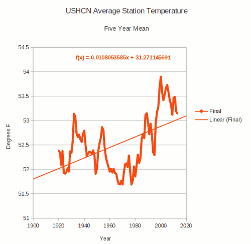
http://stevengoddard.wordpress.com/2014/08/22/thermometers-show-that-the-us-has-been-cooling-for-nearly-a-century/    (re United States Historical Climatology Network  )  WATCH USHCN FRAUD SWITCH BELOW
(For 'Final' read 'Fiddled')
Read artcle(s) for glaring evidence of fraud perpetrated by data 'selection/de-selection', and 'adjustments'/ 
modifications/'corrections' to make past processed 'data' colder and present warmer than objective honest records.
(iii) Tweets and links from Matthew Brown via
https://twitter.com/mattielb/status/502885795729272832

4. Further Comments & Forecasts General INFO

Subscription access details - ensuring you get your updates
30d forecastsAccess is to 28th of last month subscribed (uploads ~29-31st)
45d (BI) forecasts: Access is to 14th of last month subscribed (Uploads ~15-17th)
- so that next month which loads 15th onwards is excluded. 30d for that month is also loaded.
75d (BI) forecasts: Access is to 14th of month before last month subscribed
- so that next 75d month which loads 15th onwards is excluded. 
AND 45d access is given to 14th of last month subscribed
so 45d, 30d forecasts for the months load.
100d (BI) forecastsAccess is to 21st of 2nd month before last month subscribed
- so that next 100d month which loads 22nd onwards is excluded. 75d loads on ~15th
AND 45d access is given to 14th of last month subscribed
so 45d, 30d forecasts for the months load.
WINTER ONLY (BI) (started as up to 200d) forecasts: Access is fixed to 28 Feb 2015
First updates + extra detail for all months Dec, Jan, Feb and all normal updates around 15-17th, 22nd and end month will get 100d, 75d, 45d, 30d updates. 

 March Br+Ir 2015 and beyond Forecasts 
are available directly via WeatherAction office 02079399946 piers@Weatheraction.com . March (3pages) is issued 19Sep

As we go further into Mini-Ice-Age circulation in Autumn and Winter (NH) months forecasts are, as might be expected, very interesting and important both sides of the Atlantic.

What Subscribers say
Many idependent reports verify WeatherAction's world- leading significant forecasting skill (see Forecasts =>Accuracy on Home page) and from time to time we report individual user Comments and see User Comments in public blog info. 
Hear Saskia Steinhorst a Netherlands Subscriber on WeatherAction Euromaps Forecasts:-
 "(re May)....It feels like the climate is like a ping pong ball, bouncing all over the place. Keeping track is hard and would've been virtually impossible if not for Piers' EXCELLENT forecasts! ..."


5. READERS COMMENTS & FEEDBACK RULES

THIS Site is DEFENDED SPACE - 100% Moderated and troll-free because of ongoing cyber flood attacks, the misguided and mis-informed ravings of deranged greens and to stop postings which propagate misinformation or ignorance or are not of fair and honest intent or which give away WeatherAction subscribers forecast information.
The aim is to engage in fruitful informed discussion. All fair comment is published.............. 

Comments submitted - 65 Add your comment

On 21 Oct 2014, Maria 45day sub somerset wrote:

if you want to see what the wind is doing all over the uk http://earth.nullschool.net/#current/wind/surface/level/orthographic=-4.01,51.37,1306 and also http://www.xcweather.co.uk/ sounds windy out and apple trees 3m above us are bending but I feel that we are being lef off lightly with a max gust of 35. Pressure is 1011, temp out 3m above is 9 very sunny and solar effect indoors is 23 degrees and very very nice, bright and feel good factor
On 16 Oct 2014, Maria ( Ireland sub ) wrote:

Heavy downpours after last post yesterday morn. until lunch time reaching around 13 deg. dry with some short intervals of sunshine in the afternoon, some more rain overnight and a little fog this morning around 6/7 deg. start with variable sky.
On 16 Oct 2014, @Piers_Corbyn (twitter) WA Forecaster wrote:

[RE BELOW] The comment is: The biggest mobilization of the deluded and brainwashed since the Nazis - Piers Corbyn reports, see Latest Comment Blog Sorry Piers but I am saying this for your own good and that of WA and the good work it does. Please do not moderate me. I have a lot of media (trained) experience Statements like the above will do you no good or encourage new subscribers. You can make statements without using comparisons that will seriously upset many people. Those of us who post here are behind you, but please for your own sake think before uploading comments like that. The rule of thumb is do not right anything you would not like to be written about you. Keep to the science. You are truly brilliant in that field - even if I find it mind-boggling. This is sent with the kindest intentions -- REPLY Thanks for kind comm. We got a lot more retweets of this than most others because, I think, It was 1) V direct 2) True. Although it may upset some it 'got through' to many more.
On 16 Oct 2014, @Piers_Corbyn (Twitter) WA Forecaster wrote:

GILL 1066 EAST SUSSEX Re your note of 14tth Monitors deemed it gave away forecast information and was inappropriately worded and failed 'The Kitchen Test' [See Blog rules above], I (seen later) agree. It also covered matters already being dealt with. ---- Re an older note you sent which seems to have got lost in an e-mail enquiry it is now released with reply in other comm. Thank you PC.
On 15 Oct 2014, Paddy (Aberdeen south, 130m elevation, sub) wrote:

5˚C at 7.30 and though it started fairly clear early on, it clouded over soon and we actually had almost continuos rain between 9 & 11am. However, the afternoon was bright if rather cool at 12˚ with a sharp breeze from a variable E'ly direction; 8˚ by 9pm with patchy cloud & visible stars. My wife travelled down to Edinburgh this morning and said they had sunshine all the way down along the coast from about Stonehaven onwards, so there is a change but it hasn't quite reached us yet. Happy that we've not had any significant frost yet, our flowers, though looking bedraggled, are still putting some colour around the place. == Nigella: I know what you mean, I'm also waiting for the alignment; the picture on the Welcome page from the Scottish Borders is not what happened here on the 13th, as can be gleaned from my report below.
On 15 Oct 2014, Lorraine wrote:

Hawaii - I cruised from Vancouver to Hawaii in September and every time the Captain came over the communication system and he discussed the sea conditions he said 'we have been blessed:' Seemingly a lot of cyclones and storms were in the area and fortunately we got to our destination in one piece.
On 15 Oct 2014, Ron Greer wrote:

JOHN PLANET: last winter is a case in point, as the Scottish Highlands had record amounts of snow, despite the lack of severe cold. Yes, I can remember the heavy early March snow of 2006.
On 15 Oct 2014, Gill1066 East Sussex (sub) wrote:

And what was the reason this time my comment was not published yesterday?
On 15 Oct 2014, Nigella wrote:

Obs from East Berks. Sadly more rain, grey & murk. The temp has increased a little and the wind has dropped. Overnight low of 11 degs & currently just short of 13 degs. Paddy, I don't get the Euro pressure charts, I just get the B&I forecasts and without wishing to reveal details, I would have to say there seems to be a lack of alignment, which doesn't show signs of re-aligning any time soon - as far as I can tell, looking at the short-term forecasts but I am the first to admit I am no expert!
On 15 Oct 2014, John Planet wrote:

Mild winters don't always mean that you have no snow. You can get most of the winter mild but a sharp cold snap could come and last up to ten days and deliver quite considerable amount of snow. The winters ten years ago were mild but at the end of the winter there was quite a substantial cold snap which occurred in three winters 2004, 2005 and 2006 that delivered considerable mounts of snow in many places.
On 15 Oct 2014, Maria ( Ireland sub ) wrote:

Nice enough day yesterday reached 13 deg. mostly cloudy with some nice sunny spells worked in the garden till it got dark. Milder this morn. than yesterday a.m overcast dull n grey with fresh to strong south easterly winds around 10 deg. @ 8.45, rained overnight.
On 14 Oct 2014, Paddy (Aberdeen south, 130m elevation, sub) wrote:

Louis is still not showing, so we had a sharp cool NE'ly all day but no rain, contrary to MO's donkey tail prediction, we even had a little sunshine from time to time. 6˚C at 7.30, hotting up to 11˚ and down to 9˚ by 9.30 pm under a cloudy sky. == Nigella, I don't know if you get Piers' Euro Pressure maps, but the present actual map is pretty much as Piers predicted, life imitating art, so to speak, just be patient for Louis to arrive :-)
On 14 Oct 2014, Fred wrote:

One thing in particular I've noticed, when Piers' forecast doesn't match the UK its actually the inroads of low pressure or westward strength of a block. Hemispherically speaking re synoptics its still there to see the similarities.
On 14 Oct 2014, Charlie Adamson wrote:

Hello Piers,.. Fellow Weather Enthusiasts,.. It's been a while since my last post, but now that there seems to be a possible hurricane heading towards Hawaii I just had to write. Here in Michigan the forecast seems to be completely out of phase. It's been raining here though it has been warmer than usual. That being said, because I am new to Action Weather subscription services I wonder if you update regional forecasts when you see events changing that you did not see developing earlier? Should a recheck for possible new updates to my regional forecast subscription? Finally, Piers do you have any new insights into Hawaii weather? Seeing that it is so isolated from the US mainland as to being totally unique in the world with regard to its location, how do you view this region from Weather Actions perspective? What is the outlook for hurricane landfall? The last hurricanes followed your R-Factor guidance beautifully! Thank You for Your Good Work and Courage,..
On 14 Oct 2014, Maria 45day sub somerset wrote:

Clive you said that `there are times when Piers gets it wrong`. I think that needs to be qualified in that the fine detail is at variance to what actually happens during those (few) times but we subscribers have the R factors in front of us and we have learnt to use that knowledge to vary what metO says. Short term forecasts in those cases but at least they then become accurate
On 14 Oct 2014, tony wrote:

i would like to ask why the forecast i have has been so inaccurate this period ????? im not knocking piers contribution just wonder what has caused what i consider a real poor start to the proceedings .i do subscribe and will continue to do so but as ive stated before when ever i try to convince people to buy a forecast the info i give them goes all pie eyed.i know on here there are some real experts so perhaps someone can enlighten me thx
On 14 Oct 2014, Nigella wrote:

Obs from East Berks. Another damp and dreary day here. Overnight low of 9 degs, currently a dispiriting 12 degs with light drizzle. Radar showing some big old bright coloured cells to the west. Isn't quite what I had my fingers crossed for. Short term forecasts seems to be predicting a warm up at the end of the week but via a huge and rather wet looking low pressure.
On 14 Oct 2014, Clive wrote:

I remember James Madden predicted a very cold winter for 2013/14 and we ended up have a very mild stormy and wet one. The Met Office went for a cold dry winter in 2013/14 and they were wrong. The only person that I known predicted the very wet recording breaking stormy conditions for UK of last winter was Piers Corbyn. Piers was one of the only people who had told us why it was actually happening and he also predicted the polar vortex that created the exceptional cold conditions of US last year as well. There are times Piers can get it wrong yes but he has a much better track record of forecasting that a lot of others like the Met Office who seemed to get it more wrong than right in recent years. James Madden seems to predict a very cold winter every year now. He had it wrong last year and I wonder if he will have this winter right or wrong. Wait and see.
On 14 Oct 2014, Rob wrote:

Take a look at the GFS charts for 27th-29th October. THe y look a lot like the same time last year and we know what happened back then. Will lightning strike twice???
On 14 Oct 2014, Maria ( Ireland sub ) wrote:

Clear starry sky to finish last night and temps dropped, 4 deg. Start a little frost and some ice on the car window this morn. Some fog also but looks like it will be a nice day when it clears..
On 13 Oct 2014, Paddy (Aberdeen south, 130m elevation, sub) wrote:

'Louis' has let us down today, no show: the morning was showery and cool with a steady N wind, 5˚C at 7.30 rising to a max of 9˚ in the afternoon when there were a few sunny spells, back down to 6˚ by 10pm. No doubt now that autumn is here, but as Steve says, subscribers know that Louis will turn up shortly, he just has to get himself into position.
On 13 Oct 2014, Maria ( Ireland sub ) wrote:

5 deg. This morn. A little fog to start then mostly sunny with a mix of cloud drifting in after lunch, wind picked up a little for an hour was watching the leaves falling whilst taking a tea break in the sun then settled down again around 3pm max temp 13 earlier now 11 deg. @ 6 p.m with heavier cloud around again, the odd spot of drizzle and light wind, looking like it could thunder..
On 13 Oct 2014, Steve Devine (Sub) Waltham Abbey wrote:

Light to heavy rain all day here in SW Essex swirling around a slowly decaying Low Pressure cell crossing the country from South to North. Watched the Countryfile Weather forecast yesterday and Mr "Flip the Birdy" showed a mostly unsettled but increasingly mild week ahead with the chance of reaching 70f by the weekend. Mind you, to some of us that wasn't a complete surprise. Looks like the Atlantic vs High pressure may reach a stalemate with the UK in a warming southerly/SW'ly flow. Question is - how far east will the rain push across?...
On 13 Oct 2014, Nigella wrote:

Obs from East Berks. Goodness me what a lot of rain! Drove through torrential rain yesterday evening & early this morning. Saturday was dry but cool in the breeze and more cloud than sunshine until late afternoon. Sunday was high cloud haze from the start and grew increasingly cloudy as the day went on with rain starting at about 5pm. Currently 11 degs and light rain.
On 13 Oct 2014, Lorraine Lister (sub) NZ wrote:

A 6.2 quake has hit Southland, NZ tonight (13/10) http://www.stuff.co.nz/national/10611681/Quake-rattles-South-Island
On 13 Oct 2014, Piers_Corbyn (twitter) wrote:

TROLL NEWS. On 12 Oct 2014, 'David Albert' wrote...Re MARCH 2013....(Cold)...".What did you forecast for that period? I remember a posting of your forecast on here that indicated mild conditions." => Mr Albert - if that is a real name - you are a TROLL, LIAR AND WASTE OF SPACE. Just look in WeatherAction Home Page forecast archives (Does anyone else have such complete PUBLIC archives going back years of LongRange 'Forecasts' and note all WeatherAction subscribers get access to even more for each service). ALL 2013 is there (and up to recent 2014 and more in past). Our forecast was, correctly, for a cold March 2013. Go and look and note report (March News) of our correct forecast of Sudden stratospheric warnings Feb etc and Apri Forecast bulletin News Report of correct forecast detailed dates of March 2013. It appears you just made up what you wrote. We dont know if you are a MetO troll or extension of Madden. Your posting was allowed by accident and you are forthwith banned.
On 12 Oct 2014, Paddy (Aberdeen south, 130m elevation, sub) wrote:

5˚C at 7.30, pretty cloudy most of the day, 13˚ max but hardly any wind apart from a gentle NW breeze, a little rain around 7pm cooling everything down rapidly to 7˚ by 10pm.
On 12 Oct 2014, Maria ( Ireland sub ) wrote:

Yesterday was a lovely day around 14 deg. once the heavy fog cleared and the sun warmed up it was actually quite warm to work in for a few hours. 4 deg.start today no frost just foggy again although it seemed to clear quicker today, again some big clouds though less than yesterday and lots of sunshine, so similar and reached 14 again, worked too hard making the most of the fine weather outside but enjoyable so no complaints as this months forecast has been so handy to get ahead a little, trees hanging on still despite losing some leaf in the last windy spell, cold at night and can feel now that winter is around the corner.
On 12 Oct 2014, Garry gibbons wrote:

James Madden has covered the Iceland situ from the start and the danger posed from the S02 emissions. There is even an extra report for this winter and some pics of the S02 on the exacta site. I think some people are quick to judge what he has already covered here, as they don't read the info he has posted for free via the site and Facebook page. Last year he was way off the mark, and if gets this year wrong then I will never follow him again!!! If he gets the scale right, I will certainly credit him as being correct. No one else is saying anything to us! Gary
On 12 Oct 2014, David Albert wrote:

A broken clock ir right twice in a day out of 24 hours, 1440 minutes and 86400 seconds. So if we apply what Madden has got right in recent years, and he did get these right in detail! Winter 9-10, December 2010, The winter of 2012/13 and all the snow dates + March 2013 and the snow dates. That is 3 out of 5! Can hardly be compared to a broken clock being right twice in a day out of much larger figures. Sorry but I would also like to be fair to him, and he has corrected what the express have clearly overhyped immediately. Piers a question for you? I remember read an express article and Maddens quite far ahead forecast for March 2013 which I paid £3 for. It clearly defined it to be a record breaking month with the correct snow dates, just that month not April or May. What did you forecast for that period? I remember a posting of your forecast on here that indicated mild conditions. Are you saying that was luck? Because if you are I might ask Madden to pick me some lottery numbers out.
On 12 Oct 2014, Ron Greer wrote:

perhaps we should call these kinds of winter predictions as 'Snowmaddenageddons'
On 12 Oct 2014, stephen parker ( sub ) wrote:

Re james madden,even a broken clock is right twice a day!, we have a wild card with the situation in iceland, so all in all an interesting season for us weather watchers!
On 12 Oct 2014, Maria 45day sub somerset wrote:

re winter, any sensible person, with the space, is a prepper for whatever season. I have enough food for a few months, enough clothing and hobbies. Wine, chocolate, boots, thermals. We were snowed in 2010 for several weeks and survived well. Preps include alternative cooking if no electricity and a warm cosy house, I can warm one small snug with a candle and body heat. Mind blowing WA accuracy to the day here. 9.30 am no air movement at all, humidity out is 95%, fog, and thick cloud, 4 degrees at 6 am. Was another gorgeous afternoon yesterday
On 12 Oct 2014, Ron Greer wrote:

MOBEEB changing its tune a bit and now indicating that the Scottish-Scandinavian high will disappear by mid weelk or so and the weather of B&I will be dominated by a large Atlantic low bringing in mild SW air and rain, this latter being more or less as GFS predicted earlier last week. Never found the early or rapid arrival of migratory geese/wildfowl a good indicator of B&I weather, only of conditions in the far north.
On 12 Oct 2014, Craig M (@craigm350, sub, Berks) wrote:

The winter of 1968/9 is an interesting one, the kind you get from a "WildJetStream / MiniIceAge era of more very extreme events months & seasons". Here's the MetO's (then untainted by dogma & headline grabbing) summary for it: Nov (68) -"Mainly cold until the 20th then mild"; Dec - "Cold and dull. Snow around Christmas"; Jan (69) - "Dull and exceptionally mild"; Feb - "Very cold with some heavy snowfall"; Mar - "Cold and dull; very dry in the north". I came across it earlier when reading this book by Lamb highlighting the ridges and troughs responsible also for the 62/3 winter. === http://bit.ly/1wjUt5M === this winter will be an interesting one indeed Piers. The question is how long to wait for a cold snap? Will it be early (2009-10/11), mid or late (2013)? A beast? a poodle? Polar Vortex? SUBSCRIBE! // Atlantic low on MetOBeeb forecast looks a monster. Seems to be delayed from earlier forecasts in the week.
On 12 Oct 2014, Piers_Corbyn wrote:

THANKS ALL GREAT COMMS INFO -- SteveW I think your comm was just put up late not ignored. Not posts either have good reason or are posts from long-standing sad trolls which are always ignored irrespective of what they say -- ColdWinter speculation. It needs to be made clear that Madden/Express have no proven overall skill in their offerings over the last few years which have been generally OTT and largely the opposite to reality eg 'hottest ever' summers (not sure if Madden backed this one though) and 100days of ice and snow for 2013-14 whereas WeatherAction has proven high skill - correctly predicting since 2007 all the floody summers and cold and other winters - with events largely down to detail of a few days. We are now well in the WildJetStream / MiniIceAge era of more very extreme events months & seasons, however Hope'n Headline Casting while getting Extremes will often get them the wrong way around. This winter? It will be v interesting & is now on line here and I recommend!
On 12 Oct 2014, Craig M (@craigm350, sub, Berks) wrote:

Everyone - sorry for the delay releasing comments today, my battery died on me and Piers+other mods are away // Not read Madden's thoughts yet but he does seem to do the same snowmaggedon every year. I wonder if he is hopecasting? It certainly blinded me last winter, however it is looking more hopeful for snow this year due to the background factors (qbo) but I don't expect months of freeze. //Steve D - insulated in 2012 ahead of early 2013 winter after horrible mould in 2010/11. Rechecking it this year & refitting winter curtains - topping up on mulch outside. // One crack of thunder last night towards the end of a shower. Very wet ground after a heavy shower this morning with the culprit cloud bank passing west as I looked out the door. Some beautiful Cumulus congestus in the evening. Weather seems to have finally died down again for a short interlude before 24 hours of rain starting late tomorrow. Cold at night but daytime quite warmish - only two layers!
On 11 Oct 2014, Paddy (Aberdeen south, 130m elevation, sub) wrote:

4˚C at 7.30 but no frost, blue sky to begin with, no wind at all. On the whole, more cloud than yesterday but still with glorious sunny periods in between, max temp 14˚, warmer in full sun. Down to 6˚ by 10pm, wind mostly a S'ly breeze.
On 11 Oct 2014, Rhys Jaggar wrote:

'Arctic Winters' It is my considered opinion that there is something of an inverse correlation between extreme winters in the USA and extreme winters in the UK. US forecasters have predicted another big hard winter for 2014/15 for a while now, but that is not a reason to assume that the same will be true in the UK.
On 11 Oct 2014, steven wright wrote:

bit confused why my comment hasnt been published i wasnt supporting madden i think he says those things every year one year he will get it right not like weatheraction who are much more spot on every year and forecast that i do take into account however this october is simalar to october 1978 sorry if i offended
On 11 Oct 2014, john e lacey wrote:

So madden is wrong behind his global cooling precitions with piers on that one then ruari? he posted this on his facebook page last night and there is some quite interesting stuff that dates back a good five years or so which i have never seen before, otherwise i would be in the same boat of thinking as you. lets be fair to be fair here. I thought this site was troll free and supported those in favor of the misleading science behind warming fiasco http://globalcoolingnewiceageuk.blogspot.co.uk/
On 11 Oct 2014, Russ subs NE Derbyshire wrote:

>> http://www.bbc.co.uk/news/science-environment-29581411 << Is this a sign that the cold is coming? It's certainly a sign that the geese's feeding grounds are close to icing up, so watch out Paddy and Ron, better get a move on with that log-pile, you may need it this winter if those geese are indeed an omen... They didn't spread slowly across Scandinavia and into the UK as usual but instead headed quickly south.
On 11 Oct 2014, steven wright wrote:

looks like mid to end of october is going according to plan which is brilliant as im on holiday in skegness thanks weatheraction again i have seen these articles saying a cold winter is in store which at this time of year i take with a pinch of salt however on gavweather.com on his history page i was watching what happened in the winter of 1978-79 it started in september 1978 and last month and this october very simalar to what happened that year as im a snow lover i hope the same happens
On 11 Oct 2014, Ruairí (East coast of Ireland) wrote:

Madden at it again I see! Total nonsense of perhaps a hint of future winters?
On 11 Oct 2014, Maria ( Ireland sub ) wrote:

3 deg. Start @ 8a.m feels parky, very foggy, the sun looks beautiful like its trapped in a web of fog, looks like a nice day on the menu.
On 11 Oct 2014, Steve Devine (Sub) wrote:

Getting a quote from a builder today on insulating our son's bedroom with thermotiles. He has a north-facing wall and damp is becoming an issue. Want to be prepared for the Winter months ahead...
On 10 Oct 2014, Paddy (Aberdeen south, 130m elevation, sub) wrote:

5˚C this morning at 7.30, feeling very much autumnal. Cloudy but soon brightening up to blue skies and few clouds, bliss. Wind started out from W but turned to S & SE. On the thermometer it got to 15˚ but in the sun it was probably around 18˚ or more, could be "the beginning of a beautiful friendship, Louis". Whenever you were in the shade or there was a passing cloud, you could feel that it is October, the hint of winter cold is unmistakeable. Cloudy tonight but feeling mild in the stillness, 8˚ at 9.30pm.
On 10 Oct 2014, Maria 45day sub somerset wrote:

max of 18 today and what a gorgeous day, the sun has blazed all day long and I have been gardening outside in short sleeves, been like a lovely summers day. Wow, great accuracy from WA and that includes the info needed to fill the water tanks while it rained. If it continues like this then we will need to use the extra water in the tanks
On 10 Oct 2014, Ron Greer wrote:

GFS predicts a very interest contrast around the 16th with warm southwesterlies bring very mild temps to B&I, whilst much of central and northern Fennoscandia gets a full winter blast
On 10 Oct 2014, Maria ( Ireland sub ) wrote:

Chilly start around 5 deg. On the edge of a slight grass frost, some huge clouds around today some heavy looking but despite that the sun has been getting through most of the day and warm when in it around 14 deg. Nice for an October day.
On 10 Oct 2014, Lorraine G wrote:

Piers are you going to update subscribers or is October forecast going to be the same but later than you had first thought I ask because my son is getting married on the 18th hoping for sunny weather!
On 10 Oct 2014, Craig M (@CraigM350, Berks, Sub) wrote:

Gibby's summary "synoptic long term outlook is no more clear this morning as the models struggle to deal with the effect of the mid Atlantic Low next week and how it determines the events of weather over and around the UK thereafter when coupled with the anticipated rise of pressure over France and Europe later next week. Most output and particularly GFS keep the Jet flow well South and powers up some big storms later which would bring rain and gales for all but this is less marked within it's ensembles. It's hard to see where UKMOwould take us given it's relatively short model run span with GEM and NAVGEM offering a somewhat half-way house between GFS and the more interesting ECMoperational today. Should the ECM operational verify then Southern and Eastern Britain will receive unseasonably warm temperatures with dry conditions prevailing under the Southerly breeze with the Atlantic Low pressure much weaker and held well at bay for the time being." www.norton-radstockweather.co.uk
On 10 Oct 2014, Nigella wrote:

Thank you Craig & Paddy for the R explanations - that really helps. Obs from East Berks - very mixed bag still. Yesterday was sunshine & showers & today looking similar, although fewer but more slow moving showers seems to be the story. Overnight low of 11 degs & current temp 13 degs. If the sun stays out, it should be warmer than the last few days. Short term forecast suggesting we may see another sneaky Westerly moving low edge in from the East again on Sunday.
On 10 Oct 2014, Shaun (Wales) wrote:

2 points of notice recently, firstly I see the Met Office claiming to be setting up the first UK space weather forecasting. Is it just me or is that a really sneaky, lying deceitful claim when our good man Piers has been doing this very thing, this revolutionary idea they claim turns out not to be so very revolutionary as Mr Corbyn beat them to it years and years ago. Then for point 2, I see James Madden is doing the rounds again this year and has already got an Express story out of extreme, horrific cold, snow, gales, stand still and 5 months of winter!!!
On 10 Oct 2014, Ryan Price wrote:

You seem to be struggling more than your usual high accuracy weatheraction. August and now early October! Is this due to the developing LIA? Don't get me wrong you are still far better than the Met and Beeb :-) Is this why no one knows what will happen this winter? Piers yoyr thoughts on the latest Express article for an Arctic winter would be good. exacta, weatheronline and netweather all appear to be going for snow and cold and early northern blocking. do you concur? http://www.express.co.uk/news/nature/520672/Winter-weather-2014-UK-forecast-cold-snow-November
On 10 Oct 2014, Craig M (@craigm350, sub, Berks) wrote:

Nigella - easy way to see it is during R periods more energy is available so if there are storm cells about they have a bigger fuel tank - or in an R5 a nitrous tank! An R5 in a high pressure situation would be like fixing nitrous to a skip! Or to put it another way flooring it with the brakes on. Low pressure is brakes off. /// Good points by Bob Tisdale about why we should be spending on adaptation to our ever changing climate - something we've always done until a bunch of 'whippersnappers' consumerists told a generation brought up on thrift & recycling that they should recycle & be thrifty. Give a shrieking urban keyboard warrior a pension to live on before they preach? Oh I've even attracted one David Appell in the comments. I think you'll like my last reply with the Austin Powers clip. === http://weatheraction.wordpress.com/2014/10/09/maybe-its-time-we-stopped-wasting-money-studying-a-problem-and-spent-that-money-adapting-to-it/
On 10 Oct 2014, Craig M (@craigm350, sub, Berks) wrote:

Had plenty of showers some quite heavy but not much wind. It seemed only an R3 with a single crack of thunder on Weds when the warm air pushed back thankfully taking away the cold nights. Nights predominantly clear skies (moonlight gives cumulus wonderful depth). It was not so elsewhere, the tornado was impressive. video of it here === http://weatheraction.wordpress.com/2014/10/09/tornadoes-floods-and-gales-batter-britain-as-drivers-are-stranded-in-roads-swamped-with-water-with-more-on-the-way/ === M7.1 in the Pacific Rise this morning- last M7.0 was in 1920 -within ~+24hrs of lunar eclipse === http://weatheraction.wordpress.com/2014/10/09/magnitude-7-1-southern-east-pacific-rise/ === coronal field strength only moderate but fields are wide open+EFCH north & south. Solarham... "The Bz component of the interplanetary magnetic field (IMF) has been pointing south for long durations and this is contributing to increased geomagnetic activity" = more energy= 'mobility'
On 09 Oct 2014, Paddy (Aberdeen south, 130m elevation, sub) wrote:

9˚C at 7.30, no rain but dull start, some sun for a short while around 9am, then cloudy all day with showers between midday & 5pm, max temp 13˚, falling to 7˚ by 10pm with a pre-winter feel in the air, cool to cold NW breeze all day. == Nigella: R periods are global, the main influence being the sun, so that does affect the whole earth. How they play out locally is a different matter. The R5 at the end of Sept was a pussycat for us here in the NE, but very deep Low W of Greenland, 553hPa, giving some strong winds in the NW but mostly held at bay by Scandinavian High, as can happen and on this occasion was very different from Piers' forecast. In anything from R3 upwards you can expect things to happen but not always in a cinema near you.
On 09 Oct 2014, Lorraine wrote:

F.lorraine:- on our local UK news for South Devon and Cornwall there was a weather news item relating to the local met office in the area - the item was about the met team in that office studying solar weather in space😔 no mention in the item of any solar flares affecting earth weather at all just the monitoring of space westher they called it and how a flare can knock out computers etc. it just seemed to me such a common sense approach to say that the sun flares from storms affects our westher but they left it out,my reasoning was it intentionally? Or do they still believe it has no affect.
On 09 Oct 2014, Maria ( Ireland sub ) wrote:

8 deg. this morning max of 13 today, some showers earlier today and drier this afternoon with some sunny spells, feeling chilly this eve. around 8/9 deg @ 7 p.m with fairly clear sky..
On 09 Oct 2014, Gerry N Downs 600ft 45d wrote:

Very heavy rain shower at Purley this morning while waiting for a connecting train. Hammered down on the metal canopy roof and over whelmed the guttering and downpipes. Short and v sharp. Had been a sunny and pleasant start to the day. View from London indicates some more showers around.
On 09 Oct 2014, Ron Greer wrote:

GFS certainly going for an interesting month, predominantly cool and calm until mid month, with increasingly windy and variable weather thereafter with the much of western Europe getting warm African air in the last week. Northeast Fennoscandia looks set for an early Arctic blast in the next week.
On 09 Oct 2014, Maria 45day sub somerset wrote:

one shower overnight and max wind speed of 21 mph. Cloudy but not dull and sun is poking through at times. Mid day at 15 degrees and humidity 72%. No bad weather here yesterday, just one morning shower, lovely clouds in a blue sky, although dark cloud passed by at times. Romans used to grow grapes here on the surrounding protective hills, I think we have a micro climate. Some parts of uk got it bad in the R5 this week. No heating on as lowest in the downstairs in 21 degrees but usually 22. Compartmentalised house, sheeps wool insulation between floors so upstairs is 19.3 at present. Fully solar shaded at this time of year upstairs but not downstairs, so we use solar blinds because solar warmth comes in under the verandah when sun is low in the sky
On 09 Oct 2014, Nigella wrote:

Obs from East Berks. Looks like it will be a mixed bag today. Squally showers pulsed through over night but skies were clear first thing this morning. Overnight low of 8 degs and currently 13.7 degs. I still don't properly understand the R indicators and if they are local indicators or global indicators!
On 09 Oct 2014, Steve,Dorset,UK sub wrote:

Well so much for the nice autumn weather, never mind off to Spain for a break. Blowing a gale here but the grass is dry no dew this morning because of the wind, I always say that if the grass is dry in the morning it will rain during the day and it usually does, 13c this morning so warmer sun out now with towering clouds towards the channel coast. I hope we get some nice weather this month.