Comments from Piers
WeatherAction
 www.weatherAction.com, +442079399946, +447958713320 , @Piers_Corbyn,  https://www.facebook.com/piers.corbyn 

WELCOME to WeatherAction!
  • WeatherActionNewsRoom - For Feature News-articles and Extra reports for this blog go to: http://weatheraction.wordpress.com/
WeatherAction are World leaders in LongRange Forecasting
WeatherAction Forecasts are entirely different from all Standard Meteorology Efforts and have independently proven peer-reviewed significant skill - unlike all others in the field. They are based on Piers Corbyn's revolutionary Solar-Lunar-Action-Technique (SLAT). They are for LongRange decisions in Britain+Ireland, Europe and USA - and other parts of the world and oceans at times.  
They are not 'early' substitutes for short range forecasts but are for longer range planning, emergency services and trading / commodity market purposes to ~+/-1day. 
Generally for short range detailed forecasts we direct you elsewhere. 

For some specific medium and short range situations we make COMMENTS (on this blog) such as:
- Error warnings which will be needed to correct short range TV forecasts or
- Corrections to standard Met forecasts of storm tracks crossing the Atlantic or 
- Storm/Typhoon tracks in USA-Atlantic region and Pacific, Indian and Southern Oceans. 

For Full information, independent reports of WeatherAction's significant skill and archives* of past foreacsts for more than the last 12 months as well as Informative Links to other sites Go To (NB This & some other links may require copy/paste or Highlight/GoTo):  http://bit.ly/RgEuYb    =  http://www.weatheraction.com/docs/WhatAreWeatherActionForecastsAndInformativeLinks.pdf 

Archives carry all WeatherAction Web forecasts from Dec 2012 (& some before) to ~last month loaded for your reference http://www.weatheraction.com/pages/pv.asp?p=wact46 Special Asessment Reports also included.

THIS COMMENTS BLOGPOSTContents: 
0 Important Forecast Services Announcements precede News content
1  Current Top Latest Notes+TOP COMMS / LATEST PIC(S) showing developments. 
 Other Recent News - Pic Further Reports
3  Some Ongoing important news and issues - Pressing John Hammond into rational debate
4  Important General points and Subscriber assessments
5   User-Reader COMMS & TROLL FREE  RULES - YOU join in Comment & Ask Questions!

THIS BlogPost started 2014 SEPT 1st 
AUTUMN BEGINS with WeatherAction Important TOP RED period Sep 1-5+/-1d = R5~1-3, R4~4-5
In this period Short range standard Meteorology TV forecasts worldwide are likley to significantly UNDERestimate frontal activity, wind rain and speed of developments and motion of weather systems. At the same time we expect (on average) more Geomagnetic activity / proton bursts / etc

TOP FORECAST SERVICES NEWS:

UPLOAD NEWS:  Piers' Commentary: A PEEK AT SEPT: 
 Piers says: "Sept weather is often pretty boring but now with Mini-Ice-Age circulation patterns taking a stronger and stronger hold this is no longer the case. This Sept is showing some pretty zany pressure patterns In Br+Ire+Europe and the USA. This Wild Jet stream behaviour and dramatic contrasts continues through NH Autumn and Winter - and corresponding wild patterns in the SH Spring & Summer. They are all exciting forecasts and it is really interesting to see (expected) simultaneous rapid changes (Jet stream shifts) in different parts of the world.

" Another exciting aspect of this Sept is the expected EXTREME CONTRASTS across regions and through time - as happened in August but now even more acutely. The reason is that the top solar (R5, R4) drivers are present and bunched in consecutive pairs of (relative) extreme solar effect and much quieter periods in between  
  • Now a 12 month supply of forecasts is available in the present QUICK SALE for a charge of only 4 months there is no need for anyone serious about weather to stay ignorant!
  • Anyone who wants a chance to get a better world weather picture can now do it for an amazingly low charge by getting more than one service eg USA and Eu or of course "TheLot(excBIWholeWinter)" Service which covers BI, Eu, USA and 'RTQ' (Red weather, thunder/tornadoes & Quake Risk (trials) - ie everything but not as far ahead as BI-Winter-Now which has to be available seperately).
  • If you are pondering getting top weather-wise with WeatherAction - world leaders in the field,  just do it - make a club with friends - up to 7 together if it helps - or get your school to subscribe. (Nb of course business and farming customers cannot share with other businesses). Read great comms on blogs for how useful WeatherAction forecasts are over months and years.
B+I 30d SLAT10a is loaded (31Aug) 
into B+I 30d, 45d, 75d, 100d and ALL(excBIWinter) Services

Eu 30d REGIONS maps SLAT10a  is loaded (~31Aug GMT)
into Eu FULL, Eu Regions ONLY and ALL(excBIWinter) Services

USA 30d maps SLAT10a  is loaded (~31Aug/early1Sep USA times)
into USA and ALL(excBIWinter) Services

For information / subscribe / Upgrade / Extend Go to WeatherAction on-line shop: => http://bit.ly/1bAYTtM  <=

 WeatherAction coverage of the #CrisisOfClimateScience will expand with a fuller report soon following Notes from Piers in Reader Comms below on the Institute Of Physics 2Sept Presentation by Dame Julia Slingo top MetOffice scientist.  


 NEW AMAZING WeatherAction GET-NOW OFFERS!
 - HALF PRICE ALL 6m Subs & BI Whole winter
 - 2/3OFF! ALL 12m Subs 

We thank all for high interest and urge you to pass on the news of this offer to help extend forecast use and benefits. 

(6Sept) THE SALE CONTINUES until MON 8 Sep 12noon BST
This is your last chnace to get ahead of the weather at such low prices. We need to increase uptake especially of higher end of subs / upgrades, Thank you! 

Extra months in lieu are given for 'double coverage' eg upgrading to BI100d, BIWholeWinter, TheLot(xcBIWW) ETC when you have a sub covering part of new sub 

AMAZING new B+I services await you:
100d (NOW including Whole Autumn) includes 75d, 45d, 30d; 
Whole Winter (200d) NOW incl 100d, 75d, 45d, 30d for Dec, Jan and Feb
If you are serious about weather you need these!  More info below.

For Extensions to Subs we just take the extension from when the existing sub ends (we have the info and automatically check). 
For Upgrades to Subs. If you subscribe to a new service which includes something you already have (eg get BI 45d when you already have BI 30d sub) then we extend your new sub by an appropriate amount valued by the months which are double counted and/or add on anything over to your existing sub. 
You can also do upgrades directly for any length of an existing sub left to run by 'upgrade/donating' the appropriate amount and letting us know what you have done so we can ensure correct access.
Upgrades rather than extensions give you immediate forecast benefit.

For information / subscribe / Upgrade / Extend Go to WeatherAction on-line shop: => http://bit.ly/1bAYTtM  <=

Details of BI 100d & Whole Winter NOW Services

Br+Ir 100day ahead forecast at present covers  
WHOLE AUTUMN - NOV+OCT+SEP & AUG, NOW. 
NOVEMBER is single page summary with further detail soon.
OCTOBER is 4 pages in 8 weather periods with maps, no graphs
SEPTEMBER is 4 pages in 8 weather periods with maps, no graphs
AUGUST (30d) is 6 pages in 8 weather periods with maps and graphs
Sept upgrades mid Aug to 45d format 6p, 8 periods with maps & graphs
Current month Euro PRESSURE maps & RTQ are included as with 45d, 75d. 
NORMAL ISSUE / EXTENSION DATE is 22nd of each month for 3m hence 
eg Aug 22 would be normal upload date for Nov.
This service is tremendous news for Weather-serious operators in Agriculture, Emergency services, transport, holiday and retail businesses.
This 100d forecast service is available as a new subscrition or as a no-loss add-on to existing subscriptions; so months of existing (B+I 30d, 45d, 75d) services covered by this new service are credited towards extra months or parts thereof, of this new service or/and of existing service. (eg  for a 6m 100d sub an existing 45d sub being subsumed would extend 100d sub to 7m and give an extra month of 45d). The look ahead duration of an existing subscription will not be shortened. We have sub end information and automatically extend as appropriate.

 NEW Br+Ir WHOLE WINTER NOW 
(110-200 ahead) for  All winter months - DEC, JAN, FEB, NOW is released
- Currently single page summary of essential weather through the 3 months
- Updates in progress to 8 periods per month
- Then Further detail as 75d, 45d, 30d BI services - included.
SUBSCRIBERS TO THIS SERVICE get full extension credits for any months already in their current subs.  Eg if you have 30d/45d/75d subs which go up to or beyond Feb you get access to your 30 or 45 or 75d service increased by 3 months. The same applies to the 100d and the 'All forecasts except BI Winter in one' service.  For eg one month overlap 1m extensions apply.             
Subscription access details - ensuring you get your updates
30d forecastsAccess is to 28th of last month subscribed (uploads ~29-31st)
45d (BI) forecasts: Access is to 14th of last month subscribed (Uploads ~15-17th)
- so that next month which loads 15th onwards is excluded. 30d for that month is also loaded.
75d (BI) forecasts: Access is to 14th of month before last month subscribed
- so that next 75d month which loads 15th onwards is excluded. 
AND 45d access is given to 14th of last month subscribed
so 45d, 30d forecasts for the months load.
100d (BI) forecastsAccess is to 21st of 2nd month before last month subscribed
- so that next 100d month which loads 22nd onwards is excluded. 75d loads on ~15th
AND 45d access is given to 14th of last month subscribed
so 45d, 30d forecasts for the months load.
WINTER ONLY (BI) 200d forecasts: Access is fixed to 28 Feb 2015
First updates + extra detail for all months Dec, Jan, Feb will be soon and all normal updates around 15-17th and end month will get 75d+45d and 30d updates. 


1.  CURRENT-RECENT Top Solar-Weather News-Commentary - Br+Ir, Eu, USA, World
R5 (1-3) + R4 (4-5) 

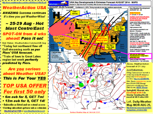
Sept 6th - New Pdf Reports on 'DoubleR' success 1-5th USA and World:

Pdf of image below: http://www.weatheraction.com/docs/WANews14No39.pdf 


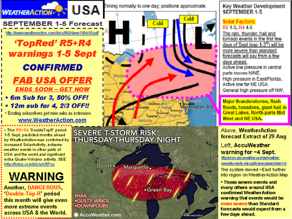
Sept 1,2,3 There is/will be loads going on - in USA and Europe / BI: Weather extremes - thunder - Large Hail - floods - tornadoes - TropicalStorm formation - quakes and volcanoes (trials) and related solar events driving it all.
See below , twitter feed @Piers_Corbyn and current  http://weatheraction.wordpress.com/  (leading on Bardarbunga Iceland volcano)

For Br+Ir the effects are largely blocked out by high pressure although there will still be some effects and plenty more is / WILL be going-on in Europe, USA, New Zealand and around the world - see below - read Reader comms in blog at foot of this post, and how about subscribing? There will not be another chance this good for a good while!

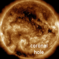
   Pic Coronal holes Sep1st. Solar wind flowing from the indicated coronal hole should reach Earth on Sept. 1-2. Credit: SDO/AIA. http://spaceweather.com/

Updating Proton Flux and Geomagnetic Kp index;
Notice (3sept) 30 fold increase in 100Mev Protons as well as lower energies. Kp not showing much yet.


USA
Large increase in sev t and floods etc beyond expectations of standard Met from a few
days before is CONFIRMED eg Nth - USA READ LINK and info below this map 
CONFIRMING WeatherAction USA forecast.
Embedded image permalink

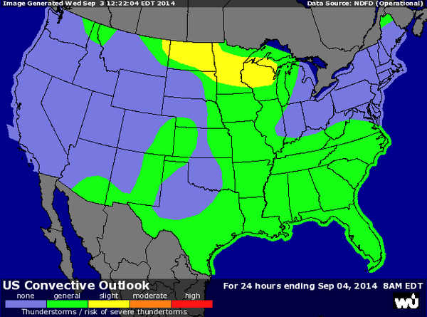
~3 sept There are many dangerous Weather events across USA: eg 
http://www.accuweather.com/en/weather-news/severe-storms-to-slam-minneapo/33384968 
A few tornadoes...very large hail and damaging wind gusts will be 
possible this afternoon (3 Sept)into tonight across central Minnesota into 
west central Wisconsin. Large hail and damaging winds will be 
possible this evening into tonight from northeast Montana into North 
Dakota. 

3 Sept  FOUR Tropical storms developing / active in R5 1-3 Sept
Embedded image permalink


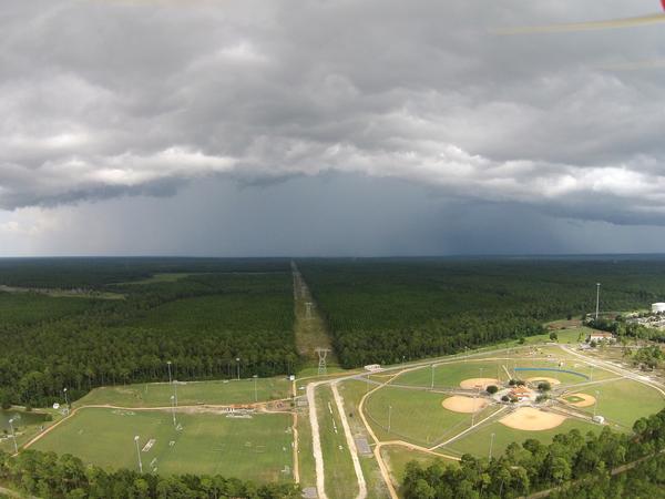
R5 starts - Panama City Florida  1 Sept about 2100 GMT  - Foreboding thundercloud

AND EUROPE
Much of Macedonia and northern Greece saw 25-108mm (1-4in) of rain Tuesday 2 Sept. This caused some localized flooding. A notably active Low in Region / nearby Med
An essential point of deep Lows SE Europe at various times in summer into Autumn was first made months ahead by Weatheraction to certain traders although timings varied / uncertain

2.  OTHER RECENT REPORTS

28Aug - Geomagnetic and aurora activity ramp up as Coronal Hole (pic 28th) becomes Earth facing and weather extremes - hail - thunder -torrential rain - hit across world in WeatherAction R5 period: see http://spaceweather.com/   SEE PREVIOUS BLOG

Superb forecast success for USA Map and heat +storms in R4 25-26th:
Pdf for pic below is: http://www.weatheraction.com/docs/WANews14No38.pdf 

Embedded image permalink


3.  ONGOING IMPORTANT POINTS+NEWS/MONITORS

23 Aug
John Hammond watch
Ignorant dishonest Co2 warmist nonsense in BBC propaganda vid:
The new vid says many things:
"A 30-year cycle in the Atlantic ocean may be behind the slowdown in global warming. John H reports for
http://www.bbc.co.uk/weather/features/28901854 = 

A glance at John Hammond's body language suggest he knows he is lieing.
 
We CHALLENGE JOHN HAMMOND TO A PUBLIC DEBATE on his ignorant, stupid, misleading, disingenuous claims
He talks about cycles 'upsetting' the warmist LIE.
FACT The sunand moon drive these (60yr) cycles as first explained 6 years ago by WeatherAction and presented in a New York climate conference, the cycles themsleves are NOT NEW.
FACT BBC-MetOffice charlatans re-invent the wheel on a weekly basis and pretend work by WeatherAction and others does not exist. They work to destroy science not build it.
FACT There is no warming but cooling. Data fraud not world temperature is on the rise.
FACT Ocean expansion is nothing whatsoever to do with the CO2 warmist LIE - it has been happening since the end of the last ice -age at a rate unchanged by the advent of Man's CO2.
To get matters straight have a look at:
( i ) RECENT TOP VIDS + PDFs by Piers Corbyn - short links
- Electric Univ Pres http://bit.ly/1nJecee 18,433 hits Aug27
- CO2 Scam Nailed http://bit.ly/QS0k34  13,873 hits Sep1
http://www.weatheraction.com/docs/WANews14No11.pdf 
http://www.weatheraction.com/docs/WANews13No43.pdf

(ii) Other links on data fraud:
http://www.telegraph.co.uk/earth/environment/10916086/The-scandal-of-fiddled-global-warming-data.html 

http://weatheraction.wordpress.com/2014/08/23/australian-met-office-accused-of-manipulating-temperature-records/

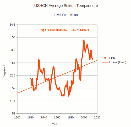
http://stevengoddard.wordpress.com/2014/08/22/thermometers-show-that-the-us-has-been-cooling-for-nearly-a-century/    (re United States Historical Climatology Network  )  WATCH USHCN FRAUD SWITCH BELOW
(For 'Final' read 'Fiddled')
Read artcle(s) for glaring evidence of fraud perpetrated by data 'selection/de-selection', and 'adjustments'/ 
modifications/'corrections' to make past processed 'data' colder and present warmer than objective honest records.
(iii) Tweets and links from Matthew Brown via
https://twitter.com/mattielb/status/502885795729272832


4. Further Comments & Forecasts General News

As we go further into Mini-Ice-Age circulation in Autumn and Winter (NH) months forecasts are, as might be expected, very interesting and important both sides of the Atlantic.

What Subscribers say
Many idependent reports verify WeatherAction's world- leading significant forecasting skill (see Forecasts =>Accuracy on Home page) and from time to time we report individual user Comments and see User Comments in public blog info. 
Hear Saskia Steinhorst a Netherlands Subscriber on WeatherAction Euromaps Forecasts:-

 "(re May)....It feels like the climate is like a ping pong ball, bouncing all over the place. Keeping track is hard and would've been virtually impossible if not for Piers' EXCELLENT forecasts! ..."


5. READERS COMMENTS & FEEDBACK RULES

THIS Site is DEFENDED SPACE - 100% Moderated and troll-free because of ongoing cyber flood attacks, the misguided and mis-informed ravings of deranged greens and to stop postings which propagate misinformation or ignorance or are not of fair and honest intent or which give away WeatherAction subscribers forecast information.
The aim is to engage in fruitful informed discussion. All fair comment is published.............. 

Comments submitted - 54 Add your comment

On 09 Sep 2014, Paddy (Aberdeen south, 130m elevation, sub) wrote:

A cloudy but less cold start with 10˚C at 7.30, overcast but still all morning and when the sun came out around lunch time temps rose to 18˚, rather nice after the chilly weekend. Saw some interesting sub-mammatus clouds, as I would call them, this afternoon; if there had been more turbulence they would have become much more pronounced, I reckon. Clear skies by 9.30pm with a grogeous not-quite-full -anymore moon, temp 10˚. == Sue H: we also noticeds swallows departing, though we still have a few, and most remarkable, we heard the first geese yesterday - that's definitely early. Autumn is undeniable everywhere, this year everything seems to come early - does that point to an early winter, and not just in the Urals?
On 09 Sep 2014, Maria ( Ireland sub ) wrote:

Wish I had charged my camera, the sunset was a corker tonight, beautiful pinks and orange amidst the grey cloudy background with the rest of the sky clear around really striking making almost purple bands between..
On 09 Sep 2014, Bob Weber, N Mich USA subscriber wrote:

Breaking news: the http://origin-www.swpc.noaa.gov/products/usaf-45-day-ap-and-f107cm-flux-forecast changed from yesterday to today. They change it quite often, and are often wrong, but it's all we have to go on for now except for following Piers' R factors, which don't explicitly predict F10.7cm flux levels. See the F10.7 forecast for the next week, where they expect a solar flux of 160, and for later they predict it’ll range between 125-150sfu. Yesterday when I checked this, the next week’s forecast was topped out at 150, and the lower range going forward was 115. So in one day they changed their forecast to a more active solar output for the next 45 days. The US Air Force can’t make and stick to a forecast for even one solar rotation. So that means we can expect a bit warmer fall than I mentioned earlier – IF the USAF F10.7 forecast is right this time. We are still in the “solar max” period, even if the previous peak levels are not reached. Solar-induced warming is still happening.
On 09 Sep 2014, Maria ( Ireland sub ) wrote:

What a gorgeous day blue sky and sun all day long, some small amount of high cloud continued and some bigger clouds just edging in here n there now at 18.17pm. Felt hot whilst finishing up the strimming in the sun clearing up for winter all the areas I left wild in summer, Temp. Reached 17 though felt more like 18/19 deg. And still 16 now but with that autumn evening nip in the air, I should say another night of 6/7 deg. On its way...
On 09 Sep 2014, Sue H (N.Ireland) wrote:

last week weather was moderately nice, no coats needed and Thurs was really lovely and warm, T-shirt weather. Fri, sat, sun felt cold in comparison. At the airshow in Portrush the wind was sooo cold, everyone had hoods up. Even yesterday, fingers were cold coming in from outside. Today? its like a mini heatwave! 30 odd swallows around the house last week, only a few now. My Dad says the swifts left his part of the country about 3 weeks ago. Trees, particularly Beech and Horse Chestnuts already part or fully yellow/brown in places. Autumn definitely here.
On 09 Sep 2014, Bob Weber, N Mich USA subscriber wrote:

Spectacular R3 kickoff yesterday as mega rain triggered by solar-induced ocean evaporation just about drowned various parts of the US. Floods in Arizona and elsewhere, reports of over 10" of rain in places. Northward warm moist blast clashed with polar vortex style southward moving cold blast created intense activity, influenced no doubt by Super full moon. Let's see who wins this time: the Sun or the Moon, as that polar air fights through the tropical thrust streaming north, setting up Piers' next forecast period quite nicely. Actually, they are working together constructively for the next week or so. After the 16th-17th, the Moon dives south and the Sun chills out, as USAF F10.7cm solar flux prediction says SF will slide downward to under 120sfu going into October. Should be a very fall-like weather pattern in NH second half of Sept. Long-duration M4 flare earlier today. I knew something was up as "they" were spraying yesterday amidst patchy gravity-wave cloud cover. Clear now.
On 09 Sep 2014, Ron Greer wrote:

GFS indicating all set fair for Scottish referendum day and the Ryder Cup, with high pressure maintaining dry weather with an easterly flow. It might even be quite warm for much of B&I. at times. Northern Fennoscandia though looks like getting an early blast of winter. All this of course is without reckoning on the R4-R5 period 15-18th---so we'll see if this benign situation will be changed.
On 09 Sep 2014, Maria ( Ireland sub ) wrote:

16 deg. reached yesterday and stayed a nice day again with a good amount of sun and yes sun felt quite hot when sitting in it directly, temps dropped to 10 last night before I went to sleep around 11 ish. Today 6 deg. This morning @ 7 a.m cool and fresh though still, not quite as parky as yesterday, sun out blue sky and some lovely cirrus cloud about up there! I think Cork reported their first frost of the season yesterday morn. Forecast spot on so far ;)
On 09 Sep 2014, @Piers_Corbyn (twitter) WA Forecaster wrote:

THANK YOU ALL GREAT COMMS espec regulars Paddy top obs, Craig (+yes top marks NewsRoom blog), Bob W (Brill solar-weather comms), Maria top obs, East side (Filling gap on the Eastern front) -- EAST SIDE re AUG BI. Yes it went wrong but not wholly. See our update pdf WA14No37 issued 1st to subscribers then public: http://www.weatheraction.com/docs/WANews14No37.pdf Basically it was off course 10th to 22nd ~13d ~ half month. The first 9d (as forecast from mid Jul) were pretty good & indeed the heat we warned of looked like possibly happening +according to others but Ex-Bertha's hit turned hot mid half month into cold. Last week AUG was on course in BI, Eu +USA (which was pretty good all mth) & in SW Russia region our explicit tornado warning was brilliantly verified in R5 27-29th, see links on revamped Home page. --- ALL Recent SALE got in many new +also 'Sleepers' not seen for ~yr. NOW mustVITAL PROMO (HELLLOW OUT THERE!) more new subs+upgrades espec to PREPARE FOR EXCITING 15-18 SEP.
On 08 Sep 2014, Paddy (Aberdeen south, 130m elevation, sub) wrote:

Bloomin' caal es mornin' at 8˚C with a cold & stiff N breeze blowing and an overcast sky, felt more like mid to late October. However, when the sun eventually came out in the early afternoon the temperature managed to climb to 17˚, especially as the breeze eventually abated, still calm tonight and 10˚, overcast and not feeling so chilly. CRAIG: you've done a great job on the WA blog, looks really good and is easy to navigate, I just need a time machine now to double up the length of the day to read it all. Where are the cloud pics?
On 08 Sep 2014, Craig M (@craigm350, sub, Berks) wrote:

Bspin - I've covered some of the Siberian 'non' summer on the newsblog === http://weatheraction.wordpress.com/2014/09/02/siberia-2014-the-year-summer-died/ === there's a link at the bottom of that story to the earlier part of the summer. A meridional jetstream pattern is very obvious this year with the transitions. More to come of course....winter is will be highly interesting going by what Piers has said - Well worth subscribing with the current offer.
On 08 Sep 2014, Bob Weber, N Mich USA subscriber wrote:

Right now, the sunspot number is 154 and solar flux is 151. On Sept 1, the SF was 123. It has been generally chilly every morning, 56F today, but I noticed over the past few days as SF has risen, that the Sun "feels" hotter, especially today, and it's not even noon here. All other weather indicators are virtually the same for us now as they were over the past few days. It was sunny all day yesterday for example, as it is today. We have no fronts nearby, we are under high pressure, there's a slight breeze, and it's been quiet for a few days. So where did that "hotness" come from? The solar flux! Can anyone else relate to that from your experience in the past few days? My solar accumulation model, based on 1961-forward sea surface temps & solar flux, indicates that the Earth warms when solar flux is over 120 solar flux units, and it cools below that threshold. USAF predicts a SF of 150 until the 14th; the moon will be at its north node on the 16th- so I expect a warmer NH week!
On 08 Sep 2014, Maria ( Ireland sub ) wrote:

Brrrrr 4 deg. outside @ 7 a.m some fog around and sun out clear sky...
On 08 Sep 2014, east side wrote:

Winter is already very apparent in Ural. This is a precursor of what is to come this autumn/winter. The temperatures dropped through the floor after 13th August, for what was already a very lacklustre damp summer. It has been cold & wet for weeks now. The pole of cold is already very well established over northern Ural, - temps shivering at 2-4C overnight even in south Ural. Forecast is cold rain for the next 2 weeks making an exceptionally early start to autumn. Don't expect minor heat waves & indian summer for long, having such an early start as a sign, already in August this winter is starting very early & will be cold, coming to you soon! It's a pity, Piers forecast for a hot August was just plain wrong. Luckily I didn't act on it & come to the UK. Out here we're not looking forward to a 7-8month winter, but it's looking already remarkably what we're going to get, with this twin peak smallest-in-a-century solar max (cycle 24). Global warming? What global warming!
On 07 Sep 2014, Paddy (Aberdeen south, 130m elevation, sub) wrote:

We managed to get away for a couple of nights, therefore no reports. Friday 5th started foggy & then it rained pretty heavily from about 9.30 - 3.30pm. Slowly improving on our drive up to Elgin, where the sun was shining brightly by 7pm and it was about 17˚. Saturday was a mixture of sunshine & showers, we managed to avoid the latter mostly, it was much colder though, max 13˚. Driving around in the vicinity of Elgin, where the land is pretty flat (& rich ground for extensive veg growing), therefore the unrestricted views of the sky was fabulous with the alternating dark & light. Drove home in the pouring rain across the Highlands, gloom & doom abounded, especially across the Cabrach. Cleared up by the time we got home in the strong N wind, but only 10˚. While we were away the min temp one night had been 7˚. Still only 10˚ at 10pm + strong N breeze.
On 07 Sep 2014, @Piers_corbyn wrote:

NEW SUBSCRIPTIONS - HELEN: The link is the same as Home page - Buy forecasts - click link to BuyNow, and there is the page and just click on the option you want eg 12m BI 45d or 75d or.... USA 30d etc and it goes into shop basket etc Thank you.
On 07 Sep 2014, Helen Dolan wrote:

Hi pierce , please can you advise me how do I get a subscription I pressed on the link for the offer for 12 months offer and nothing came up
On 07 Sep 2014, Ron Greer wrote:

GFS charts going for a fairly warm and settled September with an Indian Summer period from the last week. And in reality?
On 07 Sep 2014, @Piers_Corbyn (Twitter) WA forecaster wrote:

THANKS BSPIN & OTHERS. Btw to all subscription upgrades have to upgrade an existing subscription. Someone has paid an upgrade but there is no associated sub apparent - maybe a name change?!
On 07 Sep 2014, Steve Devine (sub) Waltham Abbey wrote:

A strange day in this corner of SW Essex. Started overcast and cool with a downpour at 10:30am. Next thing you know the skies cleared and it was wall to wall sunshine. Drove the kids to Broxbourne and the cloud reappeared. Now it's nearly 2pm, 20c and sunny again. What the ?!?
On 07 Sep 2014, Andy B 45D Farmer sub SE Wales wrote:

Yesterday we had a squally storm 10 mm in 10 minutes nice day otherwise. We had 230mm in August about 9" well above average this brings the running total to 1380mm 54" for the year so far again well above average. Beautiful day here about 20 deg.
On 07 Sep 2014, Bspin wrote:

Thanks Piers, Just 'Upgraded',couln't resist the 'Bargain'.
On 07 Sep 2014, Maria ( Ireland sub ) wrote:

Yesterday reached 17 deg. by 2pm a nice sunny autumn day with some cloud around @ times, temps dropping quicker in the evening. Small amount of mist/fog over the fields this morning, sunny start blue sky and 10 deg. Think we got down to 6deg outside last night and felt a bit chilly indoors as well..
On 06 Sep 2014, @Piers_Corbyn (Twitter) WA Forecaster wrote:

THANKS ALL FOR GREAT COMMENTS -- AND PLEASE REMIND ANYONE who needs to know our Special up to 2/3OFF SALE ends on Monday 12noon BST, 1pmEu, 7amEDT..etc. --- BSPIN Yes UPGRADES 30d=>45d a good idea. As an example if you have say 4m left to run of BI 30d and get 6m upgrade then 4 of those 6 will uo your sub to 45d. The remaining 2 upgrade credits could be used to give one more month of 45d (or if you indicated, extending 30d by 2 months so you have both a 30d and 45d sub) the calculation being done with margins in subscribers favour. There may be more choices on dealing with upgrade credits then we use reasonable common sense / email the subscriber for clarification.Thanks, makes sense?
On 06 Sep 2014, Bspin wrote:

Hello Piers, I am confused about the Upgrade option.I am thinking of 'Upgrading' from B.I.30 day, to 45 day for £40.I am partway through a 12 month subscription(I think about 8 mths.left).So how does It work out for people with say 2 mths or 10 mths left?Also does the Upgrade Include the Pressure Maps?.
On 06 Sep 2014, Steve (sub) wrote:

Where I live (beside the Forth Bridge) has been right on a WA dividing line this week and the weather has also been - well - nondescript. Apart from some slightly heavier and longer rain than expected yesterday PM it has been calm, overcast and dry with nice cool to moderate temps all week - except for some humid and hot hours on Thursday. Saw 3 entire squadrons of swans passing our airfield on Wednesday - a magnificent sight!
On 06 Sep 2014, Rob wrote:

Ron this may of some interest to you.Mountain climbers beware. Heavy rain on the 11th of August caused a hugw rockfall in the Coire an t-Sneachda area of the Cairngorms.There was another rockfall on the 2nd of September resulting in a fatality. It is believed that last winter's heavy snow was largely responsible for the weakening of the rock faces. The Mountaineering Council of Scotland are concerned that this winter with more freeze thaw action will see further damage done to the cliffs producing a toxic mix of avalanche combined with rockfall. More info on the MC of S website.
On 06 Sep 2014, Maria ( Ireland sub ) wrote:

Was sat there with my beer not long after my last post yesterday, somewhere between 5/6 PM and out of nowhere the biggest rain came down so hard for what seemed about 15/20 mins. was an amazing downpour to watch before it eased to normal rain and then stopped, some drizzle overnight I think too, has cleared the air and reading 10 deg. now @ 8.00 a.m today.
On 05 Sep 2014, Maria 45day sub somerset wrote:

Very still air, humidity is 66% and temperature outside at 8.30 pm is 21.4. Plants have suddenly got a new lease of life and I am wilting
On 05 Sep 2014, Bob Weber, N Mich USA subscriber wrote:

R4 brought torrential rain, booming thunder and fantastic lightning last night into this morning, the most lightning for the longest duration I can ever remember seeing. There was an M2.5 solar flare just over on the farside that really ramped up electric weather indices in our magnetosphere, as GOES and ACE low energy protons went up, ACE low energy electrons went up, as did ACE high energy protons, with 400km/s solar wind for days; kicking off Hurricane Norbert too on Sunday. R5 was more impressive on Sep 1 in our area. Four confirmed tornado touchdowns in N Mich Monday afternoon. Friends in Frederic made the local TV news after their woods was power-slammed by EF1 winds for only 15 seconds that dropped trees on roof and broke power poles. One reported straight-line horizontal wind and rain that he could barely walk against behind his opened umbrella on his way to the house. Now cool out West, showery in midwest, warm blast eastern US, per Piers' forecast, as were the tornadoes.
On 05 Sep 2014, Maria ( Ireland sub ) wrote:

Turned out another lovely warm day, reached 20 deg. @ lunchtime a good amount of sunshine despite heavy cloud at times, humid and a few drops of rain after 3pm looked like it could thunder but came out nice again for the early eve. lots of strimming and grass cutting done, nice eve. for a beer still 18 deg...
On 05 Sep 2014, Nigella wrote:

Obs from East Berks. Warm, very little breeze & overcast. Similar to yesterday. Top temp of 21 degs so far. Overnight low of 12 degs.
On 05 Sep 2014, Maria ( Ireland sub ) wrote:

A cooler start this morning 11deg. @ 7.30 a.m overcast with some mist and fog patches, looks like our temps will be declining here for a few days especially @ night..
On 05 Sep 2014, Russ subs NE Derbyshire wrote:

Well, we`ve just passed solar max and it`s time to ramp up those war games again. Of course, along with the uptick in flare activity recently, we get seismic/volcanic events kicking off too. I wonder what geologists are thinking about the causation of all this activity? Maybe all that extra heat from CO2 increasing has sunk into the earth`s mantle, in a similar fashion to the deep sea warming we`ve been told about. Maybe there should be a summit. A meeting of minds: geologists, physicists, climatologists, all working together to understand the world and it`s inner workings....you know, the way things used to be pre-1926 when the last big meeting took place and ended up putting science in reverse for the last century...
On 04 Sep 2014, Paddy (Aberdeen south, 130m elevation, sub) wrote:

Grey most of the day today - there is a joke about an art exhibition in Aberdeen (called the Silver City because of its granite buildings, but grey is rather more accurate) - it was "a riot of greys". Anyway, that's what we had today, fog all morning, lifting slightly in the afternoon, S'ly stiff breeze, 14˚C at 7.30, 'heating' to 17˚ max and 13˚ at 10.30pm. The upside was that we weren't roasting in our tunnels. MO forecasting rain for tomorrow, though they've already scaled back the amount since this afternoon, doesn't look to me like it's going to amount to much as we are approaching a Quiet period. R5 certainly has been held at bay by the High.
On 04 Sep 2014, Richard Brown wrote:

Fed up of this weather now.....looking forward to snow and blizzards here in the Kingston Upon Hull area!! Fingers and everything else crossed......
On 04 Sep 2014, Maria ( Ireland sub ) wrote:

The mixture of high middle and low clouds this evening has made for a gorgeous sky and sunset, dropped to 16 deg. Now @ 8pm..
On 04 Sep 2014, Maria ( Ireland sub ) wrote:

Mist rolling in across the neighbouring fields this morn. 13deg start with sun out at 7.30 a.m cloudy at times but pure hazy sky and sun for most of the day and feeling quite hot now but with a slight breeze @ 15.57pm reading 20/21 deg.
On 04 Sep 2014, Nigella wrote:

Back from my hols with obs from East Berks. Dry & overcast today but currently a warm 21 degs, with almost no breeze. Was on holiday in northern Italy & there was a massive & severe storm - even by local standards - overnight on Monday, 1st September, which would fit with the R5.
On 04 Sep 2014, richard [subs east mids] wrote:

Lorraine- we have winter to 'look forward to" lol
On 04 Sep 2014, Lorraine Lister (sub) NZ wrote:

The R5 was quiet in NZ but looks like the R4 will impact with severe thunderstorms in Northland and Auckland. Temps have been mild this week as spring begins but this can quickly change in NZ. October is often the worst month here bringing cold southerlies and hail just when fruit set is under way. This year anything's possible!
On 03 Sep 2014, Paddy (Aberdeen south, 130m elevation, sub) wrote:

The other side of autumn: dull start with a uniformly grey sky all morning, 10˚C overnight, 12˚ at 7.30, very little wind. After 10am the usual sea breeze started up, temp rose to 18 and when the sun kind of came out between 1.30 - 4pm it actually got up to 21˚, after that, thicker cloud moved in again and we had 14˚ at 9.30pm
On 03 Sep 2014, Maria ( Ireland sub ) wrote:

Overcast and 13deg. Start this morning, got quite warm and humid reached 18deg. some sun at times through the day and a little breezy this aft. Still and some cloud around now some high some low @ 21.07pm still reading 16deg. and a few stars popping out now its getting dark..
On 03 Sep 2014, @Piers_Corbyn wrote:

THANKS ALL -- HELLO + WELCOME to any who came to Dame Slingo Met office chief scientist's talk at Institute Of Physcs 2 Sept. VERY interestingly she said she was not talking about 'Climate Change' despite the propaganda pitch of the pre-lecture fliers and talked more about models. In response to questioners such as Peter Gill on periodicities. and my comment-question about equations and our ability in WeatherAction to predict solar driven changes in The Jet Stream, she was more in recognition of solar effects and what we are doing at WeatherAction than at such events in the last 5 years. We will carry a fuller report with pics (thanks Gabe!) and anything attendees wish to add, soon.
On 02 Sep 2014, Paddy (Aberdeen south, 130m elevation, sub) wrote:

Today was what I would call a glorious autumn day, blue sky all day, swallows tumbling about as if to have some fun before they have to start their long migration southwards. 11˚C at 7.30, rising to 19˚ by 10, after which and as usual, the sea breeze kicked in; however, today that was welcome, especially in our tunnels. It took the edge of the heat, it only got to 20˚ at its peak, but under the plastic we were roasting. Beatiful cirrus formations up above, it all felt like compensation for the August we didn't have. 11˚ by 10pm under a clear star & moonlit sky.
On 02 Sep 2014, Ron Greer wrote:

tut tut tut, of course the sea level is rising in Antarctica----it's the gravitational mass of the new ice wot duz it---bleedin obvious Mr Hammond.
On 02 Sep 2014, Maria ( Ireland sub ) wrote:

Overcast to start & 12 deg. A lot of high cloud around now and the sun has made it out this aft. 17 deg. now @17.09pm.
On 02 Sep 2014, @Piers_Corbyn WA Forecaster wrote:

ALL THANKS FOT GREAT CONTRIBUTIONS! ROB Yes inded they have an anti-scientific view! --- ALL watch these R5 events - including volcanoes it appears --- And dare I say ENCOURAGE ALL to subscribe / extend subs / UPGRADE to more. We want to get more people on board, this is best offer for a long time. Thank you
On 02 Sep 2014, Rob wrote:

Bovine waste product alert, This report out today says '' Melting ice is fuelling sea-level rise around the coast of Antarctica, a new report in Nature Geoscience finds.'' So we have record Antarctic ice combined with extensive melting. Piers could you please tell us what the equation for that would be or does it defy all known mathematical laws.
On 02 Sep 2014, Rob wrote:

R5 alert. Significant far side of sun flare according to NASA and Dobrovnik gets a month's worth of rain.
On 02 Sep 2014, Ron Greer wrote:

GFS indicating good weather for the Ryder Cup opening and the Scottish referendum voting day.
On 02 Sep 2014, Steve Devine (sub) Waltham Abbey wrote:

Morning all. Looks like a warm end to the working week beckons, although it appears to be a short-lived affair as winds swing round from a continental ESE'ly to a slack NE'ly as high pressure settles over Scotland by Saturday. Also looks like I'll have to ditch my cheapo Weather Station that is currently reading -40c on the outside thermometer!!! Dead batteries methinks! I hope!
On 01 Sep 2014, Paddy (Aberdeen south, 130m elevation, sub) wrote:

Mild start, 13˚C at 7.30, cloudy most of the day but in the few sunny bits in the afternoon it got to just over 19˚ and we were roasting in our tunnels where we are now packing a very good crop of trees, similar to last year's. Dry all day in a mostly SSE breeze, 13˚ by 10.30. R5 so far is a pussycat - as per Piers' comment above that we are shielded from the strongest effects by high pressure. == Also a good 'crop' of swallows this year, which is a pleasure to see; today there were dozens of them wheeling around at a good height feeding on insects and occasionally chasing each other.
On 01 Sep 2014, Charlie Adamson wrote:

Piers,.. Excellent August forecast for US. Here in Lower Michigan the heat was the greatest for the year so far, plus sticky-humid. Raining here presently on and off at a very intense rate then drops down to a steady pace. Do you have any thoughts as to why these intense downpours have had little to no lighting and thunder? Even when it happens to spark a few discharges it tends to be cloud to cloud and muted if not feeble. Thanks So Much