Comments from Piers
WeatherAction

www.weatherAction.com, +442079399946, +447958713320 , @Piers_Corbyn, https://www.facebook.com/piers.corbyn
WELCOME to WeatherAction!
WELCOME to WeatherAction!
- WeatherActionNewsRoom - For Feature News-articles and Extra reports for this blog go to: http://weatheraction.wordpress.com/
WeatherAction are World leaders in LongRange Forecasting
WeatherAction Forecasts are entirely different from all Standard Meteorology Efforts and have independently proven peer-reviewed significant skill - unlike all others in the field. They are based on Piers Corbyn's revolutionary Solar-Lunar-Action-Technique (SLAT). They are for LongRange decisions in Britain+Ireland, Europe and USA - and other parts of the world and oceans at times.
They are not 'early' substitutes for short range forecasts but are for longer range planning, emergency services and trading / commodity market purposes to ~+/-1day.
For some specific medium and short range situations we make COMMENTS (on this blog) such as:
- error warnings which will be needed to correct short range TV forecasts or
- corrections to standard Met forecasts of storm tracks crossing the Atlantic or
- Storm/Typhoon tracks in USA-Atlantic region and Pacific, Indian and Southern Oceans.
Generally for short range detailed forecasts we direct you elsewhere.
For Full information, independent reports of WeatherAction's significant skill and archives* of past foreacsts for more than the last 12 months as well as Informative Links to other sites Go To (NB This & some other links may require copy/paste or Highlight/GoTo): http://bit.ly/RgEuYb = http://www.weatheraction.com/docs/WhatAreWeatherActionForecastsAndInformativeLinks.pdf
Archives carry all WeatherAction Web forecasts from Dec 2012 (& some before) to ~last month loaded for your reference http://www.weatheraction.com/pages/pv.asp?p=wact46 Special Asessment Reports also included.
THIS COMMENTS BLOGPOST- Contents:
0 Important Forecast Services Announcements precede News content
1 Current Top Latest Notes+TOP COMMS / LATEST PIC(S) showing developments.
2 Other Recent Pic Further Reports
3 Current-Latest Forecast News+Info including solar +Geomagnetic; newest first:
- Comment and Major Report/News - often for current Weather periods'
- Independent ongoing monitor observations and reports of weather periods in User Comms / main blog.
4 Further (some repeats) commentary-Info + links & General Forecast News
5 User-Reader Comms (Troll free) Rules
6 User-Reader COMMS. YOU join in Comment & Ask Questions!
5 User-Reader Comms (Troll free) Rules
6 User-Reader COMMS. YOU join in Comment & Ask Questions!
THIS BlogPost started 2014 AUG 23
FOR WeatherAction QUIET period Aug 23-24+/-1d
In this period Short range standard Meteorology TV forecasts worldwide are likley to overestimate frontal activity, wind rain and speed of developments and motion of weather systems.
Further Weather Commentaries further below
Important comms from Readers/Observers at foot of blog pages
TOP FORECAST SERVICES NEWS:
For information / subscribe / Upgrade / Extend Go to WeatherAction on-line shop: => http://bit.ly/1bAYTtM <=
The IMPORTANT Br+Ir & Eu AUGUST UPDATE (issued Aug 16th)as in all Br+Ir services 30d, 45d, 75d, 100d; both Eu servicess and in All-Forecasts(except-BIwholeWinter)-in-One service is now made public as WANews14No37 via:http://www.weatheraction.com/docs/WANews14No37.pdfThe forecast is on closer to track from ~23rd as projceted in the Update.
Br+Ir 45d SEPT FINAL version with graphs is LOADED:onto BI 45d, 75d, 100d(info below); and "ALL-except-BI Winter" Services
Br+Ir 75d OCT in 8 weather periods is LOADED.
AMAZING new B+I servicesare loaded:100d (now including Whole Autumn) includes 75d, 45d, 30d;Whole Winter (200d) incl 100d, 75d, 45d, 30d for Dec, Jan and FebIf you are serious about weather you need these!More info below.
For Extensions to Subs we just take the extension from when the existing sub ends (we have the info and automatically check).
For Upgrades to Subs. If you subscribe to a new service which includes something you already have (eg get BI 45d when you already have BI 30d sub) then we extend your new sub by an appropriate amount valued by the months which are double counted and/or add on anything over to your existing sub.
You can also do upgrades directly for any length of an existing sub left to run by 'upgrade/donating' the appropriate amount and letting us know what you have done so we can ensure correct access.
Upgrades rather than extensions give you immediate forecast benefit.
For information / subscribe / Upgrade / Extend Go to WeatherAction on-line shop: => http://bit.ly/1bAYTtM <=
TWO 2 NEW WeatherAction Public SERVICES:
Br+Ir 100day ahead forecast (First Loaded early 120d ahead)
WHOLE AUTUMN - NOV+OCT+SEP & AUG, NOW.
NOVEMBER is single page summary with further detail soon.
OCTOBER is 4 pages in 8 weather periods with maps, no graphsSEPTEMBER is 4 pages in 8 weather periods with maps, no graphsAUGUST (30d) is 6 pages in 8 weather periods with maps and graphsSept upgrades mid Aug to 45d format 6p, 8 periods with maps & graphsCurrent month Euro PRESSURE maps & RTQ are included as with 45d, 75d.
NORMAL ISSUE / EXTENSION DATE is 22nd of each month for 3m hence (eg Aug 22 would be normal upload date for Nov).This service is tremendous news for Weather-serious operators in Agriculture, Emergency services, transport, holiday and retail businesses.This 100d forecast service is available as a new subscrition or as a no-loss add-on to existing subscriptions; so months of existing (B+I 30d, 45d, 75d) services covered by this new service are credited towards extra months or parts thereof, of this new service or/and of existing service. (eg for a 6m 100d sub an existing 45d sub being subsumed would extend 100d sub to 7m and give an extra month of 45d). The look ahead duration of an existing subscription will not be shortened. We have sub end information and automatically extend as appropriate.
NEW Br+Ir WHOLE WINTER NOW
(110-200 ahead) for All winter months - DEC, JAN, FEB, NOW is released
- Currently single page summary of essential weather through the 3 months- Updates in progress to 8 periods per month- Then Further detail as 75d, 45d, 30d BI services - included.SUBSCRIBERS TO THIS SERVICE get full extension credits for any months already in their current subs.
Eg if you have 30d/45d/75d subs which go up to or beyond Feb you get access to your 30 or 45 or 75d service increased by 3 months. The same applies to the 100d and the 'All forecasts except BI Winter in one' service. For eg one month overlap 1m extensions apply.
Subscription access details - ensuring you get your updates
30d forecasts: Access is to 28th of last month subscribed (uploads ~29-31st)45d (BI) forecasts: Access is to 14th of last month subscribed (Uploads ~15-17th)- so that next month which loads 15th onwards is excluded. 30d for that month is also loaded.75d (BI) forecasts: Access is to 14th of month before last month subscribed- so that next 75d month which loads 15th onwards is excluded.AND 45d access is given to 14th of last month subscribedso 45d, 30d forecasts for the months load.100d (BI) forecasts: Access is to 21st of 2nd month before last month subscribed- so that next 100d month which loads 22nd onwards is excluded. 75d loads on ~15thAND 45d access is given to 14th of last month subscribedso 45d, 30d forecasts for the months load.
WINTER ONLY (BI) 200d forecasts: Access is fixed to 28 Feb 2015
First updates + extra detail for all months Dec, Jan, Feb will be soon and all normal updates around 15-17th and end month will get 75d+45d and 30d updates.
For information / to subscribe Go to WeatherAction on-line shop! => http://bit.ly/1bAYTtM <=
1. CURRENT-RECENT Top Solar-Weather News & Commentary - Br+Ir, Eu, USA, World
R4 25-26, R5 27-29
25+26 Aug
New Top red R5 /R4 periods begin ~25th:
New proton hits on 25/26th - See WeatherAction home page,
Strange lights NW Pacific (see twitter feed).
Look out for extra storm/ thunder/rain etc activity from 25th.
23 Aug
Ignorant dishonest Co2 warmist nonsense in new BBC propaganda video:
The new vid says many things:
"A 30-year cycle in the Atlantic ocean may be behind the slowdown in global warming. John H reports for @BBCWorld
http://www.bbc.co.uk/weather/features/28901854
A glance at John Hammond's body language suggest he knows he is lieing.
We CHALLENGE JOHN HAMMOND TO A PUBLIC DEBATE on his ignorant, stupid, misleading, disingenuous claims
He talks about cycles 'upsetting' the warmist LIE.
FACT The sunand moon drive these (60yr) cycles as first explained 6 years ago by WeatherAction and presented in a New York climate conference, the cycles themsleves are NOT NEW.
FACT BBC-MetOffice charlatans re-invent the wheel on a weekly basis and pretend work by WeatherAction and others does not exist. They work to destroy science not build it.
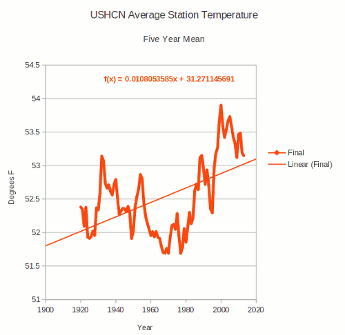
FACT There is no warming but cooling. Data fraud not world temperature is on the rise.
FACT Ocean expansion is nothing whatsoever to do with the CO2 warmist LIE - it has been happening since the end of the last ice -age at a rate unchanged by the advent of Man's CO2.
To get matters straight have a look at:
1. RECENT TOP VIDS + PDFs by Piers Corbyn - short links
- Electric Univ Pres http://bit.ly/1nJecee 18,114 hits Aug23
- CO2 Scam Nailed http://bit.ly/QS0k34 13,521 hits Aug23
http://www.weatheraction.com/docs/WANews14No11.pdf
http://www.weatheraction.com/docs/WANews13No43.pdf
2. Other links on data fraud:
http://www.telegraph.co.uk/earth/environment/10916086/The-scandal-of-fiddled-global-warming-data.html
http://weatheraction.wordpress.com/2014/08/23/australian-met-office-accused-of-manipulating-temperature-records/
http://stevengoddard.wordpress.com/2014/08/22/thermometers-show-that-the-us-has-been-cooling-for-nearly-a-century/
3. Tweets and links from Matthew Brown via
https://twitter.com/mattielb/status/502885795729272832
21 Aug Geomagnetic Activity shows large uptick in R5-R4 periods 18-22nd:
(23 Aug) Compare this with updating Geomagnetic Activity graph on Home page re Quite Solar fcators period ~23-24Aug - and look out for all change in following days!
If you havnt got a forecast go to http://bit.ly/1bAYTtM

20 August USA
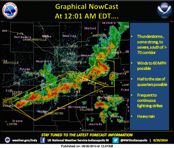
Massive thunderstorms trashing ~Mid-West confirming #WeatherAction USA detailed LongRange Forecast issued 3 weeks ahead for R5-R4 periods 18-19 and 20-22Aug.
19 August
Waterspouts Gulf of Genoa confirm WeatherAction Euro forecast in R5 period 18-19th

There were also extreme hail and rain / flood events on 18-22nd in other parts of Europe, USA & world (eg China, Japan)
2. OTHER RECENT REPORTS
Piers Corbyn August World note - issued end July
Hello"! The August forecasts for Britain + Ireland, Europe (including possible Pressure maps), USA and Quake Risk are very exciting. On a world scale records of heat, cold, floods and hail will be under attack and some will be broken. WeatherAction world leading forecasts will help to look watch and prepare for events - no one else has WeatherAction's skills.
The reason for the extremes is the wild jet stream behaviour which brings extremes of heat and cold. These are the most exciting batch of forecasts for a while and well worth having for planning purposes.
=> (Comment added 23 Aug) WeatherAction Forecast users can see that these warnings were well confirmed world wide with EXTREME hail, thunder and flood (and Quake-volacano) events during WeatherAction ~R5,R4 periods in USA, Europe+BI, India, China, Japan, New Zealand...
The AUGUST forecasts - for Br+Ir, Eu & USA - highly recommended (note at end July)
Overall the cold blasts in the Wild Jet Stream Age cover wider areas and appear to be more prolonged which is why the main feature historically has been the extreme cold winters and wet summers with damaging hail in Britain, Ireland and Europe - which have severely damaged crop yields. This aspect of the Wild Jet Stream Age gave it its other name - Little Ice Age or now we use Mini Ice Age after Boris Johnson found that more illustrative. It is not a "one way" climate shift but but a bag of extremes.
RECENT TOP VIDS by Piers Corbyn - short links
2. Electric Univ Pres http://bit.ly/1nJecee 18,114 hits Aug233. CO2 Scam Nailed http://bit.ly/QS0k34 13,521 hits Aug23
see also http://www.weatheraction.com/docs/WANews14No11.pdf
3. LATEST FORECAST NEWS+INFO
- UPLOAD NEWS
Br+Ir 45d SEPT
SLAT10 awaits you - on B+I 75d, 45d, & "ALL except BI Whole winter" Services
Br+Ir 30d AUGUST
SLAT10 awaits you - on B+I 75d, 45d, 30d & "ALL except BI Whole winter" Services
USA 30d AUGUST
SLAT10 awaits you - on USA & "ALL except BI Whole winter" Services
Euro Regional Maps 30d AUGUST
SLAT10 awaits you - on Europe FULL, Euro Regions ONLY & "ALL except BI Whole winter" Services
Euro PRESSURE Scenario Maps 30d AUGUST
SLAT10 (Aug1) loaded - on Europe FULL; B+I 45d, & 75d & "ALL except BI Whole winter" Services.
World RTQ* 30d AUGUST
SLAT10 (Aug2/3) loaded - on RTQ, Europe FULL; B+I 45d, & 75d & "ALL except BI Whole winter" Services.
*Red Weather, Thunder/Tornado+Cyclogenesis, Quake Risk. NOTE The RTQ table now explicitly includes cyclogenesis (eg Tropical Storm Formation/Rapid Development = FRD periods)
Are You Ready for more extremes?
WeatherAction gets it right when others fail so it's time you got serious about weather with WeatherAction - under our brill end month deal. Get Weather-wise!
WeatherAction gets it right when others fail so it's time you got serious about weather with WeatherAction - under our brill end month deal. Get Weather-wise!
Sub charges, 30d forecasts, last 10 days of each month (=from 22nd) start from SEPT and is Aug free.
**For any service Upgrade charge = Rate per month X numb of months. **Use Upgrade button or pay difference via Donations button and send message via 'ContactUs' (or we work it out if it is obvious).
All details & Deals at on-line shop http://bit.ly/1bAYTtM
4. Further Commens and Forecasts General News
As we go further into Mini-Ice-Age circulation in Autumn and Winter (NH) months forecasts are, as might be expected, very interesting and important both sides of the Atlantic.
Up to 30d ahead forecasts for Britain+Ireland, USA, Europe and 'RTQ (Red weather periods & thunder/tornado+Quake risk) for May have been performing well.
As we go further into Mini-Ice-Age circulation in Autumn and Winter (NH) months forecasts are, as might be expected, very interesting and important both sides of the Atlantic.
What Subscribers say
Many idependent reports verify WeatherAction's world- leading significant forecasting skill (see Forecasts =>Accuracy on Home page) and from time to time we report individual user Comments. Hear Saskia Steinhorst a Netherlands Subscriber on WeatherAction Euromaps Forecasts:-
"(re May)....It feels like the climate is like a ping pong ball, bouncing all over the place. Keeping track is hard and would've been virtually impossible if not for Piers' EXCELLENT forecasts! ..."
5. READERS COMMENTS & FEEDBACK RULES
THIS Site is DEFENDED SPACE - 100% Moderated and troll-free because of ongoing cyber flood attacks, the misguided and mis-informed ravings of deranged greens and to stop postings which propagate misinformation or ignorance or are not of fair and honest intent or which give away WeatherAction subscribers forecast information.
The aim is to engage in fruitful informed discussion. All fair comment is published..............
=> FOR RULES GO TO http://www.weatheraction.com/docs/USERCOMMENTRULES.pdf