On 10 Aug 2014, GerryB(30day sub) wrote:
Set out from Benfleet Essex to drive to Louth, Lincolnshire at 7:00am,arrived at just after noon having experienced worst driving weather in 60 years.
Torrential rain from joining A14 to arrival in Louth, at time monsoon like, still many with no lights and others driving like maniacs!
I've driven in the Arctic on ice at 100mph and today was more scary. Ice driving at that speed no longer possible as studded tyres used in 60s are now illegal.
On 10 Aug 2014, Nigella wrote:
Obs from East Berks. Saturday was dry and sunny until mid afternoon, remained dry but clouded over. Today, raining and windy all morning.
On 10 Aug 2014, Rhys Jaggar (30 day annual subscriber) wrote:
After nearly 2 inches of rain a week ago, we are now experiencing another steady downpour this morning as I write (10am Sunday 10th). As these showers have both been in hit-and-miss cloud formations, I guess other places not too far away may still be on target for SE rainfall prediction of August 30d summary.
I"m not objecting at all as the garden has needed at least two dousings after 6 weeks of almost no significant natural rainfall.
On 10 Aug 2014, Carrie Spurgeon (East Yorkshire) wrote:
Yesterday mix of sun and downpours. Overnight cooler and very wet. Today (Sunday) very overcast, grey, cool and rain looks to be the order for the day. No wind to speak of.
On 10 Aug 2014, Saskia Steinhorst (Neth.sub.) wrote:
@ Gerry ND - Thanks for the advice, means I don't have to lug a large suitcase ;-) / @Paddy: alas, no star gazing last night. Busy swapping bedrooms for the kids (my eldest is sweltering with his PC on all day and is moving to the rear bedroom) and fine-tuning things before leaving The Boys by themselves for a week for a much needed break in London. / OT: The R5 periods have certainly thrown the emergency services for a loop here. Any predicted rain basically turned into torrential downpours throughout the country; the internet is rife with emergency calls concerning flooded shops, basements, roads, etc. All these from Aug 2 onward. Here we still have the 'watered down version' of all the troubles elsewhere: some good rain but no flooding. The wind, however, has been strong enough to shake unripe fruit from the branches and snap off medium to large branches as well. Nothing major, just at odds with 'usual' August weather. R5 again? This morning cloud covered sky but muggy and warm.
On 09 Aug 2014, Maria ( Ireland sub ) wrote:
Some heavy downpours some fab clouds and even some lightning n thunder this aft. Around 3-6pm not huge but close enough to enjoy, tailed off for the evening so wasn't bad in the scheme of things :) 12/13 deg @ 22.58
On 09 Aug 2014, Paddy (Aberdeen south, 130m elevation, sub) wrote:
Very heavy rain in first half of night, slow moving over the east, we could hear it and see it on the radar this morning. 12˚C at 7.30, overcast with stratocumulus and cloud fragments moving along below in a cool SE wind which turned into the NE for a while late afternoon. Brightening up around 3pm and actually getting quite warm at 22˚, sunny end to the day, clear sky with a beautiful almost full moon rising in the east. 12˚ at 930pm, feels like the temp could drop to below 10˚ overnight. Whether MO with its blanket yellow rain warning for the whole country is justified remains to be seen since the R5 has come to an end, more likely pale yellow custard :-). == CRAIG, I sent you a reply to a comment on craigm350.wordpress.com to get details for uploading. == SASKIA: the Perseids are from the region of Perseus, which is just 'above' the Pleiades (belonging to Taurus) towards the Pole Star. Tonight would be great for stargazing here but the moon is too bright.
On 09 Aug 2014, Gerry N Downs 600ft 45d wrote:
Watched the cloud increase yesterday evening while out harvesting blackberries. Shortly after dark the rain came and continued at least 3am but stopped by dawn. Clouds clearing to give sunny spells with a breeze from w to sw and warming up as the day goes on. The cricket should be interesting tomorrow as at 1459 on the live reporting it says that the forecast is 'horrendous'. Easy to see if that is true or not. Good news re off-shore windmills. There is no right for windmill operators to be able to put a cable across your land if you don't agree. In Lincolnshire 5 landowners have refused citing damage to field drainage systems and need for inspection points every 750m. A little spanner in their works. Your suggested travel wardrobe sounds fine for London with the UHI effect. It's been shirtsleeve order in town for weeks. Grateful of aircon in train on way home.
On 09 Aug 2014, Richard Traut yearly sub Redcar wrote:
Certainly not predicted by the met/bbc .....
http://news.uk.msn.com/uk/britain-braced-for-bertha-backlash-2
it came early as far as those two organisations are concerned,. Temps has cooled down the last 2 days more notably today 18.5c from 22c-23 cthursday.friday.
thanks,Richard.
On 09 Aug 2014, Saskia Steinhorst (Neth.sub.) wrote:
@Paddy - Yes, Pleiades, of course! Has been years since I last intentionally went out to see them ;-) / OT: Started raining yesterday evening, on and off. Walking the dog at 2 AM meant having to wear a light rain jacket in case of downpours, but it was uncomfortably muggy and hot. Wind picked up to a good 7BF and is still going strong this morning. Temps still higher - and much longer on-going than previous years! - than usual at above 22-24C with hefty downpours throughout the morning. In between, however, the sun comes out at full strength again. Both wind and rain coming in from the West, pretty a-typical. Guess we can consider this 'a little present from Britain' ;-) Question: seeing how I will be in London 14-19 August, can anybody confirm that packing plenty of t-shirts and just the 1 sweatshirt as well as a light rain jacket is the proper way to go?
On 09 Aug 2014, Nick, Berks wrote:
Not too concerned about who forecast what at this stage (there was a discrepancy between the BBC web site forecast showing no rain and the MO yellow warning for rain yesterday) just very grateful for the much needed 12-13 mm we got yesterday evening which fell without much drama. Different story for my mother up in Yorkshire, close to Bramham, which I note on the MO website recorded the most rainfall yesterday at 64 mm. Mother says it was as bad as she can remember - supported by http://www.yorkshirepost.co.uk/news/main-topics/general-news/video-tornado-above-motorway-as-storms-trigger-flash-floods-across-the-region-1-6776827. Other parts of the east seem also to have got a fair whack - http://www.itv.com/news/story/2014-08-08/parts-of-britain-hit-by-flash-flooding-after-heavy-storms/. Let's see what tomorrow brings; I would welcome more rain but less so wind.
On 09 Aug 2014, Russ subs NE Derbyshire wrote:
So with the end of a double R5 period in mind, we got caught in an amazing downpour yesterday around 5:30. We headed to Sainsbury`s to stock up on comestibles for the weekend, and it started to rain, hard, then harder, and harder. We sat in Sainsbury`s car park watching people running to & fro, getting a good soaking for their efforts, unsure whether to brave it and join the idiotic (dark, pouring rain, busy car-park), dash for the entrance, or sit it out a little while longer. We waited until the rain abated somewhat, then ran, then stopped. The approach to the entrance was 2 inches deep and we quickly tip-toed through but as we entered the doors we were met be the security staff trying to push the water back through the doors, King Cnut style, yelling out that the store was no closed. Dozens of shoppers were wading out of the shop in at least 3 inches of water. We were told by a shopper that the water had gone about 30 feet into the shop up to the first fridge section. Those R5s huh?
On 09 Aug 2014, Piers_Corbyn twitter wrote:
ALL THANKS --- CLIVE, STEVE CRAIG Great COMMS. Good points notice 1: Our LR Forecast for CET is about mean temps and so night min important (which is why in Express I was circumspect about daytime max records being topped even allowing for dodgy data). We forecast a thundery Aug especially of isolated intense variety in 5-8th eg; Clive's point is great for humid warm nights. 2: Right Now we are in MO / standard Met PEAK LIKELY UNSKILL where UNSKILL is Forecast Error divided by look ahead time. Just after/ at end of R5 MO error in this case over-forecast of activity is greatest and look ahead to say mid Sunday is only one day. I would estimate that the next successive runs will decrease rain wind thunder in forecasts for (south) England. It is also likely that their intensifying Low in N sea later and other wind Monday is OTT.
On 09 Aug 2014, Maria ( Ireland sub ) wrote:
Nice enough morning 17deg. feels like its warming up again, some big white fluffy clouds some grey heavy sky and patches of blue between, sun has been about all morning...interesting read on wind farms in Ireland Craig..
On 09 Aug 2014, Clive wrote:
They say there is going to be below average temperatures but the warmth of the seas around UK could mask the cooling. We could still end up with the rest of the month being warm and unsettled with the cool air being pushed upwards into the atmosphere in a form of thundery showers. Polar marine air going across warmer seas tend to bring warm thundery conditions with sunhine and heavy thundery showers rather than cool dull wet conditions that we have in a proper cool wet summer. Something like 2004. If the high pressure does take over again then things would heat up considerably again.
On 09 Aug 2014, Steve Devine (sub) Waltham Abbey wrote:
Craig M - Before I forget; loved your last two posts!
Ahem. Right. Bertha. According to the latest charts, Ex-Bertha will be a damp squid that pretty much brings rain to the southern-most counties of England with not much wind left in it by then. The Jet Stream begins by cutting a swathe through the English Channel (which may intensify this non-event at the last minute), but then goes on a kind of polar vortex route originating in Greenland and cutting a path across the UK from NW to SE. Pressure charts have us in a mostly NW'ly flow for the forthcoming week.
That's all from me folks. Back in a week! :-)
On 09 Aug 2014, Craig M (@craigm350, sub, Berks) wrote:
I may not be a scientist but I know when I smell something that came out of a cow's backside (cow pats have uses so I apologise to all bovines). Apparently Americans are imagining cold things as the year to date in the US is only the 41st coldest since 1895 (read Bob W's comment, read Tony Heller's piece and please comment & pass widely - you'll not see a much more overt case of lying/tampering by the scumbags determined to make 2014 'the hottest ever') === http://bit.ly/1A196gT
/// Ireland fights prayer wheel bribery ===
http://bit.ly/1A19ig7 === // Search Gamechanger Salon or check the comments on the CBC article by Hillary Ostrov === http://hro001.wordpress.com/
=== Paddy - details sent so you can send pix direct and will host over at the pebbleskies.wordpress.com blog (it's just for weather images).=== Finally a bit of light relief === http://weatheraction.wordpress.com/2014/08/08/met-offices-julia-slingo-gets-ready-for-winter/
On 09 Aug 2014, Craig M (@craigm350, sub, Berks) wrote:
Nigella-big thanks for your morning update. BBC forecast (provided by the MetO) had NO rain (not even a cloud with a solitary drop) at all! I saw your comm about the radar & as I was reading could hear rain outside. I checked the forecast for here, City of London & 10m West just to be safe - no rain. Okay a passing shower feature but even at 4 pm in the afternoon the nearest rain was for 1-2 am on Sunday. I could see the mass of rain approaching & approximated arrival in about 2-3 hours. Finished work & forecast says 'light' showers from 7-9 then overcast (all screengrabbed). Radar showed this made as much sense as relying on a prayer wheel for your morning cuppa. Looked up could see 'ruffles' in cloud indicating a band of approaching rain. Few spots of rain by 6.30 then at 7 the heavens bloody opened. People scurrying for shelter all over town. Now 1 am & STILL raining. Miserable stuff. Most people like drowned rats. Thanks MetO you useless ****s. 'Super' computer my ****!!!
On 08 Aug 2014, Paddy (Aberdeen south, 130m elevation, sub) wrote:
Quite cool overnight at 10˚C, 13˚ by 7.30, bright sunshine until 3pm, wind SE most of the morning but when cloud started moving in it turned into the NE on the ground but the clouds above were still moving in a SE - NW direction. Looking at the radar I could see that a lot of rain was crossing the country from W to E, but it only got to us just after 9pm, some of it quite heavy. MO have a yellow rain warning out for our area. 13˚ at 10pm. == I got quite excited this afternoon as there was a good display of asperatus clouds which I managed to take pictures of - CRAIG: I'm a bit out of touch, is it still possible to post cloud pictures on pebble skies?
On 08 Aug 2014, Maria ( Ireland sub ) wrote:
Pale Yellow Custard is exactly what the Yellow warning inc. us in Leinster put up this a.m on met.ie that I didn't bother to mention earlier looks like here! We have blue sky and sun after a few short lived downpours earlier, a little breezy but a nice August late afternoon/early eve. 19 deg earlier, family travelling back on Sunday to Cornwall we were all hoping for a ferry cancellation but unfortunately I said their trip back should go ahead according to Piers forecast, so without further ado we will get straight back to beers and chat while we have some time left together ;-)
On 08 Aug 2014, Gill1066 East Sussex (sub) wrote:
My MO forecast all day yesterday promised a lot of rain this morning. Not here matey........ though it has tipped down in a few places I hear. Yesterday's 'cooler cloudy day' turned out hot and sunny (26c) , so I went on my annual hols....... sat on the seafront for an hour and ate ice-cream. Bliss! Sunday is our charity cream tea day..... think I'll 'wait and see'. Do hope August temps rocket back up at some point.
On 08 Aug 2014, Henry wrote:
Scottish Borders around 2.30 several loud thunder claps and torrential rain. Raining heavily on and off till now 18.15.
On 08 Aug 2014, Piers_Corbyn wrote:
THANKS ALL - I am just back from a presentation to Dorset gliding club which was great fun and where the MO meanderings on forecasting ex-Bertha were noted to be as wild as the mini-ice-age wild jet stream which is now the norm. THANKS ALL especially Steves RICHARD CRAIG, LORRAINE nigella etc fir COMMS. Keep watching Bertha! I have no change in what we said ahead of all on the track - ie France rather than through ire and Brit. Notes 1 our further south rightward turn compared with MO dire warnings-possibilities is being confirmed. 2 from in an R5 = now MO MODELS over forecast beyond = sat and sun. So expect LESS THUNDER ETC sat sun. Their Yell warning should be downgraded to pale cold custard where most of the colouring was left left out. ---- THE LOT HALF PRICE OFFER is still on and remains a great deal for this summer-of-Let's-get-weather-serious so uptake should be more. Thanks PC.
On 08 Aug 2014, Russ subs NE Derbyshire wrote:
Just looked at the August forecast detail again for this period up to and including the 8th. Piers couldn`t have been more accurate if he`d painted a set of pictures, produced a detailed storyboard, paid Steven Spielberg to produce a feature length video, and telephoned every subscriber personally to discuss the forecast details more thoroughly. I`m seriously impressed dude, especially with the increased use of the words possible and probably. This is the UK weather we`re talking about here, and even master craftsman Piers has to produce the occasional bent nail, although his latest August 30 day update is about as bang on the nail head as you can get. And all for the cost of a pint of beer per week.....awesome!
On 08 Aug 2014, Gerry N Downs 600ft 45d wrote:
Heavy rain has brought the Test Match to a halt at Old Trafford and here we have this gem:- BBC Weather's Sarah Keith-Lucas: "It's not going to rain continually, but there are thunderstorms on their way. It's a mix of sunny spells and scattered heavy showers lasting until 7pm this evening. This is nothing to do with Bertha, but we are set for a dry night and it should be good on Saturday. During the course of Sunday, we are waiting to see if there will be strong winds and heavy rain." Erm..what happened to the 'we can forecast 5 days ahead' if Sunday (less than 48hrs away) is still a mystery? Sounds like a powered-up rainstorm. R5 at work as the solar wind is still above its resting level? Yesterday was a return to the heat but has been overcast in London today and cooler.
On 08 Aug 2014, Nigella wrote:
Interesting few days of weather ahead. Even Piers suggested uncertainty over this period, which just shows what a tricky little corner of the world the UK is to forecast for! The radar is showing some heavy areas of rainfall to the East of me already this morning & the skies here in East Berks are overcast & grey but it is still dry. The Icelandic Atlantic forecast has been showing the remains of Bertha tracking over the UK to some extent all week & is now showing it affecting most of the UK on Sunday. However, it looks like after that things should calm down a bit. So glad I live somewhere with lots of 'weather'! Rarely a dull moment.
On 08 Aug 2014, Maria ( Ireland sub ) wrote:
A grey day yesterday with quite a bit of rain, some showers were quite heavy and humid no thunder but could have done with some to clear the air... grey start again this morning 15 deg...
On 08 Aug 2014, Craig M (@craigm350, sub, Berks) wrote:
Just had a look at the latest CET values. Provisional mean temp to 6th Aug is 17.3 +1.2C. The line for the 6th has it touching the 10th percentile which is top ~24.// Sadly when the MetO announced 'July makes eight warm months in a row' people think this is a sign of human induced change. Blogger xmetman highlights 7 other periods of above average temps in a series starting Nov 93 - 94/5:8, 99/00:9, 02/03:11, 03/04:8, 04/05:12, 06/07:15(!), 09/10:10. So on av. just over every 2 1/2 yrs. Interestingly the 6 consecutive months in early 2013 were the only one in the series**. // 2014 will be a warm year in an overall warm 12 months (bar Nov) but one thing noticeable looking at the past 30 yrs is that sharp periods of warming are followed by steep drops. A warm 94-5 was followed by drop in 96-7, the warmth of 06-7 was followed by a drop 2008-10 after a cold start 2011 stayed warm into 2012 then we had a drop into 2013 when we bounced back up. MIA!
** http://bit.ly/1u3L8k
On 07 Aug 2014, Paddy (Aberdeen south, 130m elevation, sub) wrote:
A grey, rainy and unpromising start with 13˚C at 7.30. It did lift however and turned into a nice sunny day with variable winds from a general S'ly direction. This kept the top off the temps and we only reached 21˚, but that's fine with me, easier to work in reasonable temps. There was quite a lot of flat bottomed cumulus cloud further inland, at one point looking as if it was going to rain but didn't. Back down to 13˚ by 10 pm. == Saskia, the present meteor showers are called the Perseids, coming out of the region of Perseus. We can't see much here unless we go to bed much later than usual, still fairly light until 10pm. Summertime star gazing is zilch for us from May to August.
On 07 Aug 2014, Lorraine Lister (sub) NZ wrote:
The R5 is hitting the south of the South Island of NZ as expected http://www.stuff.co.nz/national/10361919/Snow-blankets-south
On 07 Aug 2014, Craig M (@craigm350, sub, Berks) wrote:
Remember the 'Piers Corbyn Storm of October 2013' (aka St Jude)? He hasn't said this enough but he warned of it FIVE MONTHS beforehand (in detail six weeks before to within one day)=== http://weatheraction.wordpress.com/2014/08/07/piers-corbyn-on-where-we-are-heading-in-the-next-25-years/ === just wow!
On 07 Aug 2014, richard [subs east mids] wrote:
Another hot day. Plenty 25c readings about recently lol. Maybe a bit of panic setting in as Meto do a vid giving 4 different outcomes for Bertha as they get their excuses in first? https://www.youtube.com/watch?v=9qq2zYgEfJQ. The 'friday washout' has been downgraded as they now expect the french storms to go to holland. 5 day forecast NOW has Saturday with NO rain after having it heavy rain all week lol. Remember the priesthood were backslapping over these incoming storms at the beginning of the week as they rubbished anyone else who didn't agree to the official party line lol. So 72hrs before Bertha the official astrologers i mean forecasters have no idea and basically say look out the window for friday and sunday. Maybe they do their best work in the staff gym? Meanwhile Cobra/MOD/Insurance have to rely on their kind of very expensive product. Is short range forecasting possible?
On 07 Aug 2014, Steve Devine (sub) Waltham Abbey wrote:
Thanks Bob. I'm an admirer of your insights and commentary on here too by the way. It was literally half an hours work comparing Tropical Storm data on Wikipedia with Piers' RTQ forecasts which detail Solar/Lunar activity, earthquake and volcano potential. If anyone else has time out there, it would be worth seeing whether Full/New Moons had any bearing whatsoever on those very same storms, or maybe not those ones necessarily. Research = facts / evidence cementing the fact that Piers' research is nailing the impact of the Sun and Moon on our weather and climate. My time is very limited so any assistance would be much appreciated. Thank you! :-)
On 07 Aug 2014, Steve,Dorset,UK. Sub wrote:
A dry sunny day here with the occasional bit of cloud and feeling hot in the sum,
This from the warmist press via WUWT site.... Quote.....
Eric Worrall writes:
The Washington Post has in my opinion stooped to a new low, by trying to tie the ongoing Ebola misery in Africa to the issue of Climate Change. According to the Post;
Will they stop at nothing with the lies about this warming scaming.
On 07 Aug 2014, Maria 45day sub somerset wrote:
3.30 pm, actual temperature in the shade is 26.4. Met o says max is 20 today. (met o wrong yet again ) Heat is def building up, not a cloud in the sky. Deadly to unprepared people on holiday
On 07 Aug 2014, Bob Weber, N Mich USA subscriber wrote:
Steve - awesome research! ACE, accumulated cyclone energy, a wind index, closely follows solar activity. You just demonstrated that in a roundabout way. The lunar tidal effect may have a lot to do with these storms too.
On 07 Aug 2014, Steve Devine (Sub) wrote:
Hi Piers et all. I've been asked to see whether there is any correlation between top RX warning periods and tropical storms or severe weather on a global scale. In short-there can be no doubt...
St.Jude/Piers Storm Max 120mph gust 26-31/10/13; 24-26/10=R4,27-30/10=R5...Bodil/Xaver affected Ctl Europe 4-10/12/13; 2&3/12=R5,6-7/12=R5,10-12/12=R4...TS Boris Max 40mph winds hit Guatemala/Mexico 2-4/6/14; 1/6=R5...TS Hagibis Max 50mph winds struck Philippines to Japan 13-23/6/14; 12-14/6=R5...Hurricane Arthur swept from Bahamas to Quebec Max 100mph gusts 1-7/7; 30/6-1/7=R3; Cyclone Neoguri Max winds 155mph affected Guam to Japan 2-13/7; 2-3/7&9-10/7=R4; Cyclone Rammasuri Max winds 155mph affected Philippines to Vietnam via China 10-20/7; 9-10/7=R4,15-17/7=R5...TS Matmo swept from Philippines to Korea via China 16-26/7;R4 then double R5s...TS Halong/Jose sweeping through Philippines 7/8 during R4/R5 period. Sorry I haven't time for more analysis Piers but I've got 2 kids to entertain ;-)
On 07 Aug 2014, Craig M (@craigm350, sub, Berks) wrote:
Nigella - oops! It was Gill that asked a few days back! Was a bit late when I was writing this morning! Well that's my excuse and I'm sticking to it :)
On 07 Aug 2014, Nigella wrote:
Thank you Craig for that explanation - but I think it was someone else who must have asked the question. Interesting nonetheless. Obs from East Berks - turned into a warm day yesterday, with high of 26 degs. Looks like it will be warm again today, although a lot of bubbly cumulus springing up. Short term forecast suggests it is going to be quite a rainy day in SE tomorrow, which is a shame as my kids are off to Thorpe Park. Although maybe the queues will be shorter!
On 07 Aug 2014, Lorraine Lister (sub) NZ wrote:
The double R5 is having an effect across NZ http://www.stuff.co.nz/national/10357459/Gales-hit-snow-falling. In our region we've had rain today but it wasn't cold, no strong winds. Looks like it will be a lot colder over the next few days.
On 07 Aug 2014, Craig M (@CraigM350, Berks sub) wrote:
Nigella - how is globe still warm? A few things - Continuous temp adjustments (warm present, cool past). Readings taken hundred of miles apart 'homogenised' i.e. using very different conditions/climates. Remove colder rural recording stations, keep the warm airport/urban ones. Satellites are adjusted & differ greatly. Sadly fanatics are in charge of datasets. UHI - Lamb writing in 1972 noted a difference between outskirts & heart of city 4-5C (obs from 50s). Oceans move slowly in transporting heat (decade(s) lag). A heated bath (ocean) in a warm room (atmosphere) takes time to cool. Arctic only really started warming in late 90s but multi year ice is on the increase again-PDO(pacific) was warm but flipped cold, the AMO (Atlantic) is still warm & all the heat from the sun in prev decades is still leaving the system via the poles. An awful lot of energy is being released to space The Antarctic looks to be cooling quick as Southern Oceans cool. ..and SC24 has *just* peaked.
On 07 Aug 2014, Maria ( Ireland sub ) wrote:
Mostly overcast today temps up to around 18, feeling cool this evening & 8deg now @ 1.31 a.m
On 07 Aug 2014, Craig M (@CraigM350, Berks sub) wrote:
New blog item on Bertha is now top story on weatheraction.wordpress.com - this evenings model updates have thrown a spanner in the certainty from earlier. Bertha was more southerly than tonight's updates. Nothing special really but keep an eye as it is going to keep changing as it's a R period. Anyway this has the usual images & record of forecasts (before they get rewritten in the model/MetO back slapping fiesta that follows a nowcast) /// Met Office have a yellow warning for Friday. Uncertainty expressed in the TV forecasts over this (Less than 48hrs away). Subscribers - have a reread of the current section of the forecast including the uncertainty & look to the SE corner/// Been quite warm the past few days when sun's out +often muggy - no 'fresh' feel to the wind but not the relenting heat/humidity of last month. Much easier to sleep. Bar last night solid fall most rain has been patchy & localised. Sky has the humid look of tropical air not the crystal clarity of polar air.
On 06 Aug 2014, Craig M (@CraigM350, Berks sub) wrote:
Bob - try === http://www.weatheronline.co.uk/map/vor/euro/d.htm === US maps & presentation far superior in my experience. Will reply to your comment on blog after I get an article out of the way. /// Everyone - thanks for the weather memory comms. Looks like winter 1978/79 was an interesting period in BI. Anyone else have something from that winter? (the articles might take a wee while but they will come). /// Side working on my winter thoughts (I do my own one independent of WA for fun) but NO 13/14 warm rainfest - QBO is shifting & the sun quietening. Less zonal train but Atlantic influence (storms) still likely. If I see a polar vortex in our vicinity (must be our turn this yr) I'll start doing a rain dance to draw the moisture our way...although wet snow (& winds) cause major destructive problems (see winter 1916/17 which followed wet winters 1914-16). ///
I've put up quite a few videos on the news blog === http://weatheraction.wordpress.com/category/video/
On 06 Aug 2014, Paddy (Aberdeen south, 130m elevation, sub) wrote:
Foggy start, 14˚C at 7.30. MO changed its rain forecast again this morning, i.e. predicting more again than they said last night. In the event, it started raining shortly after 8am and carried on in varying quantities until after 4pm, some heavy bursts in the afternoon, by which time it had also got quite sultry & sticky, reaching 22˚. Clearing up thereafter with even some sunshine, winds mostly from a S'ly direction and light, 14˚ by 10pm. The wet is not unwelcome & will make veg grow even faster now, we're overflowing with food. == Rhys Jaggar, always interesting to read your crop reports. Everything is early here also, a friend who goes to a monthly farmer's market said that things grow so fast they have to throw some of them out in order to keep up with harvesting good quality in between markets, so they don't end up with over-ripe cucumbers, courgettes & beans.
On 06 Aug 2014, Steve (sub) wrote:
I am always looking for new ways to astound the average sheeple about how little Co2 is in the air. (The un-scientifically-minded ones think air is about 70% oxygen and 30% Co2!!!) I found the page "air seperation" in wikipedia has a nice big pie-chart showing everything graphically - and rememberwhat a tiny proportion of even that small amount is down to humans. Sad really that the scammers had such an easy job on the peoples of the world - so many that obviously were off school that day!
On 06 Aug 2014, Maria 45day sub somerset wrote:
The showers have ended, not had many but they were power showers, thanks to R5, so now all the water butts are full, 1000 litresI am ready for the rest of august and feeling very happy at the excellent soaking the clay soil has had. Right on target again PC. It is almost 22 degrees here at 8.30 pm and has been a warm day all through, heat feels as though it is building again
On 06 Aug 2014, Saskia Steinhorst (Neth.sub.) wrote:
Saw some gorgeous meteors this night and the night before at about 2:30 AM local time. One in particular was beautiful, traveling from N to S and lasting almost 5 seconds with a bright orange trail! - OT: overcast skies, yesterday even with some lovely but threatening looking mammatus (?) and ominous, rotating storm center but only a spattering of rain. Yesterday the KNMI even warned (!) for water spouts, and one was indeed sighted near one of the isles. Despite warnings of thunderstorms and rain, all we have is warm to hot weather with sunny/overcast skies and continuing dry conditions. Congratulations, mr. Corbyn. You're doing it again ;-)
On 06 Aug 2014, Bob Weber, N Mich USA subscriber wrote:
richard, thanks for the link. It still amazes me that weather and temperatures can vary so much across the globe at various latitudes, etc. We are barely "average" today on the 45th parallel, whereas you in the UK at higher latitudes, you're "boiling hot" - so there is one reason to think things are building up to Piers' hottest in 300 years forecast! Our garden stalled out in July, the cherry tomato plants are barely waist high and thin with fruit, whereas last year they were over my head and loaded. From the comments made here it is apparent many enjoyed an earlier start and better growth conditions at higher latitudes in the UK this year than we did in Michigan.
On 06 Aug 2014, richard [subs east mids] wrote:
This week Meto 5 day forecast for the week has gone from full sun to heavy rain back to full sun and sat/sun keep changing each time i look at it. They forecast mostly rain my location today but its been boiling hot. The guy who last year in oct predicted with normal meteorological reasoning the wettest winter for a long time also got endless crank criticism because Meto had said it would be a drier than average winter but how many apologised when he was proved right? In science there are those who look for evidence as the basis of science and there are those who look to 'reputations' as the basis of science . If people listened to the blinkered 'reputations' at the Royal Society we still might not have had the longitude clock :)
On 06 Aug 2014, @Piers_Corbyn (twitter) wrote:
AUGUST etc - JOYLON thanks for note. There are a number of sad cases on Netweather and other blogs who have difficulties in reading, learning & comparing like with like and who have no skill in long range forecasting and just boil with anger and envy at the proven skill and success of our solar (non Co2 non standard Met) approaches. Similar remarks were seen on the net for our forecast for Dec 2010 to be ~coldest in 100 yrs etc, the rest is history but these people still have difficulty in recognising facts. On this Aug note 3 things 1 We said (end July and) start Aug would be mixed. 2 TV forecasts (as example of standard Met lack of skill even in med-short range) /BBC said the Commonwealth Games Glasgow would be fine all through; our forecast said they would NOT, and we were right. 3 It's ridiculous to assess a forecast until it's over and even more crazy to define reality as a MO forecast, yet this is what some of these Commenters do without reading our 80% confident detail. Wait!
On 06 Aug 2014, Steve Devine (sub) Waltham Abbey wrote:
Afternoon everyone! After a very wet night just north of London, the rain cleared about 9am and it has felt very warm in the occasional sunny spells with temperatures climbing to 23c here, more like 24/25c in town.
The Jet Stream outlook has it doing an ox-bow lake curve diving down into NW France then hooking up over SE England. Then by Sunday when ex-Bertha is predicted to come close, the jet stream is much flatter and ploughing pretty much along the south coast / the English Channel, all subject to change of course. Hopefully I'll be out of the country on holiday by then but at present it looks like the vast majority of the UK will miss out on this non-event, which looks much more likely to rustle some leaves in France instead.
As per other comments, I'm beyond tired of cynics on Netweather and other troll-ridden sites taking a pop at Piers. His success rate is undeniable. No-one ever said he was perfect, but his methods are pioneering and he always makes corrections and expla
On 06 Aug 2014, Rhys Jaggar (30 day annual subscriber) wrote:
A good half inch of rain overnight, much needed here in NW London. The odd shower since, with warm sunshine in between.
Unbelievably, apples are ripe a month earlier than normal, blackberries have been picked for a week already and the autumn raspberries are now high summer raspberries. Tomatoes are 3 - 4 weeks earlier than last year, with even the early April sowings beginning the harvest in late July. Runner beans and dwarf beans also started harvesting 29th July and are now providing 6oz each every day with no sign of the crop finishing before the end of the month.
On 06 Aug 2014, Gerry N Downs 600ft 45d wrote:
Rain started around 1am on The Downs but had cleared by morning - well around 7.15. Clouds cleared to sunny spells now in London. Colleague from Dartford had heavy shower when he left home. Cool evening with cloud drifting in by sunset. Much better temps for sleeping as Nigella said. Scoff as the ignorant may, but still the solar wind is blowing about its resting level as per the forecast. Looking at the Sat24 pressure forecast they have a nice big high sitting to the east through to the weekend which could deflect the Atlantic lows around - a blocking high no less. A work place comment on tv forecasting - 'it's 50-50 whether it will rain or not. We don't know.' Very helpful. Another colleague is off to Las Vegas soon where it was 79F and heavy rain the other day!!!! Lots of news of record minimums on Iceagenow. Good piece from the Die Kalte Sonne crew on WUWT re no warming in Portugal for 19yrs.
On 06 Aug 2014, Joylon wrote:
Hi Piers, The boys in the netweather forum are having a pop at you now :-( I'm always a big follower of your predicts and think that the work you have done is a credit to humanity!!! But I'm guessing from these comments that we can kiss goodbye to the August heatwave? Or are they wrong?
http://forum.netweather.tv/topic/79882-model-banter-moans-and-ramps-springsummer-2014/page-37
On 06 Aug 2014, Nigella wrote:
Obs from East Berks. Some much needed overnight rain and a fairly decent amount - 6mm. Overnight temp dropped down to 12 degs, which is the lowest it has been in a couple of weeks, which meant we all slept well, despite it being humid. Was very overcast this morning, but the cloud is breaking up now, with blue skies showing. The Icelandic Met Office Atlantic pressure charts, which I tend to use for my short term forecast & I have a reasonable degree of faith in, is showing a series of low pressures running across the UK over the next 4/5 days. None of them are looking too scary at this point & they seem to be predicting more rain from a low on Friday than anything from the remnants of Hurricane Bertha on Sunday. Will be interesting to see what happens.
On 06 Aug 2014, richard [subs east mids] wrote:
Bob-yes i suppose WA have to go where their method takes them and so far its been consistently right more often than not and certainly better than the self proclaimed official experts. In the uk the hottest august thing has been taken up as a stick to beat WA with by the co2 modellers who are crowing and smirking about the Atlantic storms coming in although the recent one they 'predicted' went mainly to france- hoho. Unlike them if WA gets it wrong they look at improving their method while hockeystickers etc just sit around thinking they have solved it all and there is nothing better despite they cannot forecast anything barely 12hrs ahead eg this weeks 5 day forecast that has been spinning like a forecasters fruit machine. I use http://www.weatheronline.co.uk/ which gives some options under expert charts
On 06 Aug 2014, Bob Weber, N Mich USA subscriber wrote:
Could any UK/European WA subscribers please direct me to the best weather sites for comparable current images such as all the The Weather Channel produces here every ten minutes or so for the US? http://www.weather.com/maps/maptype/currentweatherusnational/uscurrentweather_large.html It would help as I am attempting to expand my review of Piers' forecasts beyond the US, where all of my daily focus has been since October. "Will we see cyclogenesis in August?", I asked at the end of last month ... and then we DID see cyclogenesis in the very first week of August! Well done Piers! It would be great if people were actually paying attention to what Piers says and what goes on after he says it! I'll be looking for a blocking high or something that will enhance the "super" lunar atmospheric tide peaking northward Aug 20 to put Piers' 300 year August temp forecast over the top. Very bold prediction I might add... that's the Piers Corbyn we know! It's amazing but not surprising isn't it?
On 06 Aug 2014, Charlie wrote:
Just checked in on the Eastern Pacific hurricanes and to my keen interest, I find that Julio has blown up into quite a presence. It will be more than interesting to track the effects of the R5 condition with these storms. Normally forecasters begin to play back the "logic" that says " this storm will be tracking over the churned up waters in the wake of the previous storm so it will likely run out of fuel and begin to weaken".
This is a great opportunity for Piers and his team to access some extraordinary insight and data on the high R-factor influence no matter how things turn out.
We could be in for some "Perfect Storm" exciting times.
Go get Them Piers,..
Charlie
On 05 Aug 2014, Paddy (Aberdeen south, 130m elevation, sub) wrote:
Really bright & glorious start, though only 12˚ at 7.30 but soon rising to 22˚ max, only held back by the pretty stiff SSE breeze which kept going all day, only abating in the evening. We went further inland for a picnic today as we have a friend visiting, no midges thanks to the wind, though the flies were pretty persistent trying to land on us. Lovely cirrus clouds in all sorts of shapes, by midday thin high stratocirrus started moving in, but back home there was less of it, sun shining right into the evening; 14˚ at 9.30pm. When the weather comes from the west we are often spared the thickest cloud & heaviest rain. MO is predicting heavy rain for tomorrow afternoon; knowing their "accuracy" I still watered my trees tonight, as on many previous occasions this year, never regretted it. Plenty rain in the south on the radar, R5 today, so not surprising.
On 05 Aug 2014, Charlie wrote:
Piers,.. I have questions about the weather here in Michigan, specifically concerning lightning.
I have noticed that here in Southern Lower Michigan, there have been days which have been picture perfect where clouds seemed to have been placed in the sky with an even spacing and precision. I did see that the sky had a deep clear air blue to it which reminded me of winter high-pressure skies.
Is there something that is contributing to this that you are reminded of?
Next, I have noticed that the storms during late Spring and early Summer have VERY little lightning ground strikes. Also that the lightning tends to prefer cloud to cloud discharge. It even sounds strangely different with a more soft almost gentle report instead of the usual CRACK after very long rumbles that go on for 5-15 seconds.
Being a lifetime lover of lightning I seem to pick up on these things.
Do you have any possible insights into these events?
Thanks Again,.. Charlie
On 05 Aug 2014, Charlie wrote:
Hello From Lower Michigan, USA,..
Piers,.. Things seem to be getting interesting. With friends in Hawaii I have noticed that the period that Hurricane Iselle is due to reach the Islands, is also within the R5 pair.
Would love to get your take on how this could effect the development. Personally I get the idea that during R5 periods storms seem to get more energetic. What do you think?
Thanks for your courage and being true to the Spirit of Science.
Charlie
On 05 Aug 2014, Maria ( Ireland sub ) wrote:
Yesterday was mostly bright and sunny around 20deg. Light S wind yesterday and today.
Some showers @ times today overcast humid around 17 deg.
On 05 Aug 2014, Gerry N Downs 600ft 45d wrote:
First NASA say we are due a hit from a CME on 2 Aug. Then it becomes 'it is late or not coming at all'. Are they trying to rival MetO for forecasting. Despite their claims, I notice that the solar wind has been showing an increase in speed and density for the last couple of days. So once again Piers nails the solar effect for timing. Pleasant temps at the moment - not too hot. More cloud around today in London.
On 05 Aug 2014, stephen Parker wrote:
Well Eastside, i say time will tell, and we havnt got to wait too long to find out
On 05 Aug 2014, Gill1066 East Sussex (sub) wrote:
MO cannot forecast weather correctly for the next day let alone next weekend. Yesterday's cool cloudy weather for mid-day turned out bright, sunny and very warm. Tomorrow is supposed to be very wet. Do I believe them or just go ahead and water the garden tonight anyway. Very dry withering hydrangeas need a drink.
On 05 Aug 2014, Allan wrote:
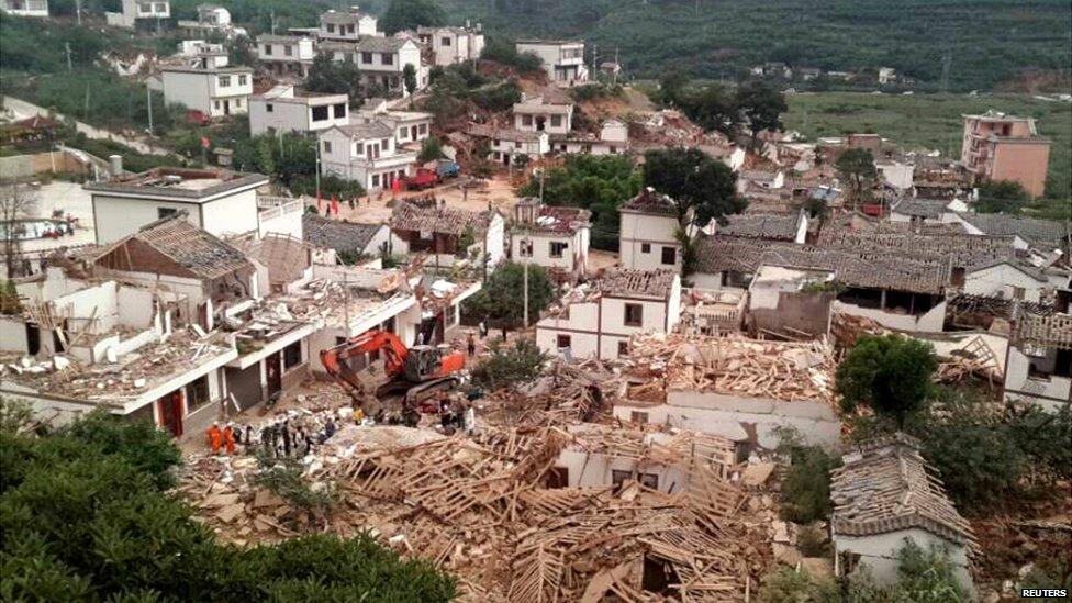
Great going Piers. The big China 6.1 quake was in an R5 spell. Pity it made sad news, hundreds dead. There was also the big 6.9, 6.1 double quake just a few hours earlier in the ocean to the north of Papua New Guinea. Luckily it only loosened a few coconuts.
On 05 Aug 2014, richard [subs east mids] wrote:
Super full moon on 10th [ie close to earth]
On 05 Aug 2014, Nigella wrote:
Obs from East Berks. Cooler last night with overnight low of 13 degs. Seems strange that a drop of 2/3 degs should make so much different to overnight sleeping. Very overcast this morning & I can see on the radar showers already coming in from the west. Had made arrangements to go for picnic supper with friends this evening - but think we'll be amending that to an indoor picnic!
On 05 Aug 2014, east side wrote:
Fascinating to see the MO are currently forecasting Bertha to hit the UK, then they say, the summer will be over with miserable autumn conditions, so the newspapers are copycatting.
One thing we can be certain of.
The MO track record, is so BAD, we can say with near certainty the exact OPPOSITE will take place.
In the current set of JS figures/trends, the high pressure and JS pressures will be too high for any effect on the UK, so who is going to take a bet on this call?
The JS will fry the UK in August as Corbyn predicts, and the MO once again with egg on their faces, then go into denial!
So:-
Bertha powers down and goes WELL SOUTH over the south of France and nothern Spain causing deluges in northen Italy and the Balkans but the current heat wave continues in Eastern Europe, Russia and intensifies over the UK, Poland, Germany & France?
What do you reckon?
On 05 Aug 2014, richard [subs east mids] wrote:
Shaun- liberal democracy highest ideal is not about being a good human being but about getting rich. To get rich you have to distort truth ie evidence based science. From iraq dossier to co2 hockeystick the 'liberal elite' play tricks on the public to transfer wealth from the many to the few. BBC says it is not impartial on several key social issues including co2 . Greed is not about wanting things greed is wanting more than you need. Avarice= greed + envy ie it means its not enough that you do well others MUST fail. Hockeystick narrative is the basis not just for taxes but multi billion $ interests So the original lie is co2 is making the world warmer. As you say the evidence is it isn't. None of their predictions have come true and so they just keep increasing the timeline for them hoping the income stream doesn't dry up before they have filled their boots. The public are not only being robbed of truth and money but sometimes their jobs and lives as well
On 05 Aug 2014, richard [subs east mids] wrote:
1-4 August 2014 Forecast review- pretty much what happened for my location ie "Showers end becoming,dry fine, sunny & warm". The SE stayed about 22-23c ish. So 1.0 out of 1 for Aug so far. I see Meto 5 day seems to change every hour depending when you look at it. So far for this week each day has ranged from dry sunny to heavy rain so they covered all the bases. Whatever happens they can say 'we predicted it' lol
On 04 Aug 2014, Paddy (Aberdeen south, 130m elevation, sub) wrote:
16˚C at 7.30, quite sunny, alternating with cloud cover, good W breeze gradually turning into the NW during the day. Occasionally feeling fresh in the wind but still managed to get 24˚ max, a reasonable summer's day for these parts, 16˚ again by 10 pm. == RON: looking at the grey alder I planted in a nursery bed as 18" whips in the spring, some of them are now 4' tall, remarkable growth this year, shame I didn't plant many more in our forest which is now pretty full.
On 04 Aug 2014, Shaun (Wales) wrote:
One thing I notice... I am a long distance runner and read many adventure, racing books as well as racer biographies.
When these guys tell their stories it has no hidden weather agenda, in fact many of them believe in AGW, but when discussing the days conditions I frequently encounter from running blogs around the world, snow later in the spring that usual, more snow than normal, colder etc etc.
One example, just reading a report from the Iceland 'fire and Ice race' and they state they have had a recent 40cm snow fall on the race route which is unusual for this time of year in their parts they state.
Anyone else find non weather related comments in the same contradictory manner to the bias BBC
On 04 Aug 2014, Steve Devine (sub) Waltham Abbey wrote:
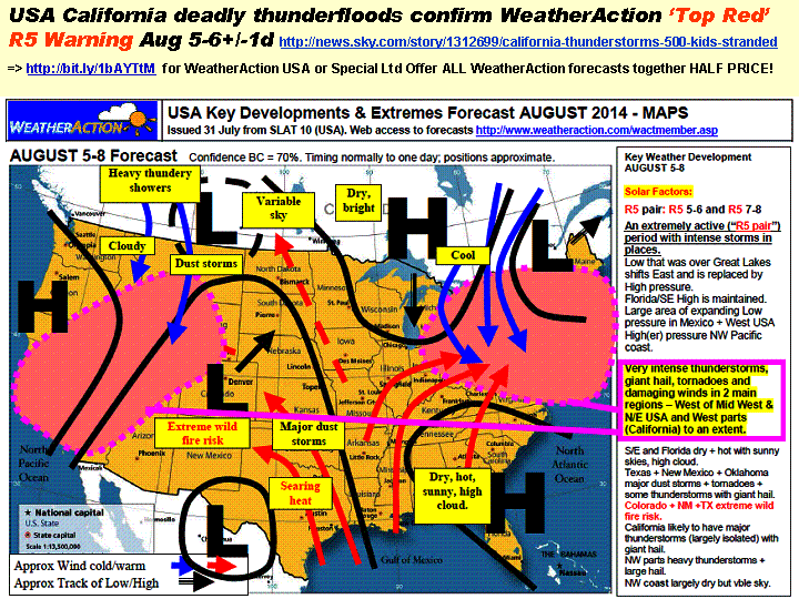
2000 stranded in extreme flooding and landslides 50 miles NE of Los Angeles, 1 fatality, houses buried in mud http://news.sky.com/story/1312699/california-thunderstorms-500-kids-stranded. It struck a day earlier than the 5-9th Double R5 period with Piers stating "Very intense thunderstorms, giant hail and damaging winds" in this region. More to come by the sound of it. Bullseye Piers!
On 04 Aug 2014, Ron Greer wrote:
STEPHEN PARKER: The MOBEEB are going for a night minima of 2C in northern Scotland, which if the air is still, means a good chance of a ground frost. August frosts are normal in northern Scotland, but it will come as a shock after the long warm spell. Cool and windy today, with bursts of warm sunshine. I am not a professional forecaster but my gut instinct is for a similar winter to last year with perhaps a colder spell in Feb-March.
On 04 Aug 2014, Stephen Parker wrote:
Re Ron Greer: one forecaster saying that the remnants of hurricane Bertha arriving next weekend will upset the hot august forecasts, with lots of rain for the south. As usual, time will tell.Whats your thoughts for this winter?
On 04 Aug 2014, Rob wrote:
Well if anyone watched the Cycling Road Race in Glasgow city centre yesterday they got well and truly soaked. MO went for a mainly dry scattered possibly heavy showers forecast but from about 10am to 5 pm it was steady and heavy/very heavy reulting in only 12 people actually finishing the race. It felt vey much like an autumn day for sure.
On 04 Aug 2014, mike waller wrote:
Was up in Glasgow yesterday for the last day of the games, watching the city cycle races at Le Col de Montrose Street. Several inexperienced riders actually stalled on the climb and it was only the roars of the crowd which kept them going. Anyway, just after lunch there was one of the heaviest storms I've ever experienced (hope it was obvious on TV). The rain came down in sheets, the street became a river, and at the bottom there were huge fountains coming up through the drains. Didn't hear thunder, but there were severe squalls, putting paid to many umbrellas. Spectacular!
Mike
On 04 Aug 2014, Saskia Steinhorst (Neth.sub.) wrote:
Started raining this night but dry this morning. Not a lot of precipitation, certainly not enough to replenish dried out soil. Day started overcast and cooler (19C at 9AM) but is starting to clear and warm up. We have large flocks of birds around the house as I have put out not only food but water as well. - Off Topic: today marks the 100th anniversary of the start of WWI. "The war to end all wars." And yet global tensions and geopolitics seem to be more volatile than ever. We haven't learned much, I'm afraid.
On 04 Aug 2014, Angela Tewkesbury wrote:
Hi Sandy, I also followed Mr Strettons post and noticed how they behaved towards Piers prediction or have little knowledge of the weather. James Madden of Exacta Weather also defended how himself and Piers use different factors on the site, even though there August forecast differs. He also made some very valid points to be abused by what appears to be a collection of trolls and cyber attackers. I hope they are all proven wrong in all fairness.
I would have commented but was scared to get attacked myself in the post starting from the 30th July: To counteract the Daily Express forecast, the Daily Mail have decided to write off the rest of summer with August to be cool and wet. dated 30th July... It is awful!
https://www.facebook.com/WeatherWatchUK?fref=nf
Also keep up the good work Piers and I hope you prove these amateurs wrong.
On 04 Aug 2014, Nigella wrote:
Obs from East Berks. Saturday was overcast in the morning & then sunshine & showers in the afternoon. Bit cooler with high of 24 degs. Sunday was mostly sunny with a strong breeze, again a bit cooler than the last few weeks, with top temp of 24 degs. So far today, there is a fair bit of high cloud and seems likely to be cooler again, with temp at the moment at 20 degs. Short term forecasts seem to be predicting a run of lows coming in from the West but who knows!
On 04 Aug 2014, Ron Greer wrote:
Most standard forecasts not going for heat this week, with GFS already vascillating from its chart for 14th-18th--but-- now going for an outright Arctic outbreak on 20th. If true, then summer is over and it's early autumn. However since it's GFS I won't be looking out my thermal semmit just yet!
On 04 Aug 2014, Ron Greer wrote:
MOBEEB weekly certainly not going for any great heat, but rather a mild low-pressure dominated period with uncertainty over a SW approaching low at the end of the week. No doubt we can expect sudden changes to this with no reference to immediately preceeding predictions.
On 03 Aug 2014, Paddy (Aberdeen south, 130m elevation, sub) wrote:
16˚C at 7.30, foggy, still & mild. MO still had yellow warning but no rain in sight on radar, in fact, their warnings contradicted their forecast for the day. Around 9am the fog lifted, the sun came out and it got reasonably warm, to 20˚ but no more because of the strong and fairly cool S breeze, it being returning polar air wrapped aroud the Low sitting on top of Britain. We had some pretty beefy pulses of rain early in the night but got off lightly compared to further west & north. 15˚ by 9.30pm and feeling a bit chilly. == The summer so far has been good to us, I have to say, produce is flowing out of garden & tunnel as everything is quite a bit earlier than normal. Continuous big harvest from climbing French beans in tunnel, raspberries in full flow.
On 03 Aug 2014, Saskia Steinhorst (Neth.sub.) wrote:
@Paddy - Ditto over here; the predicted 'extreme thunder, rain and hail' never arrived. Instead we spent a joyous 30 mins bicycle ride at 9PM with a few spatterings of rain. Cooler here as well, today temps barely reached 22C which felt almost chilly compared to the previous days./ @Maria - They do say you are influenced by circumstances you were born to. Who knows, this might include the weather as well, although as a Summer child I particularly dislike the season. More a fan of Autumn ;-) / OT: Dutch KNMI predicts temps 'lower than usual' as of mid-Aug.
On 03 Aug 2014, Maria ( Ireland sub ) wrote:
Warmed up to 18/19 deg. a shower late morning, dry warmer afternoon with some sun and cumulus cloud around, still breezy but an improvement on yesterday...
On 03 Aug 2014, richard [subs east mids] wrote:
China expecting extremes next 3 days "Temperatures could hit 37 degrees Celsius in many regions, including Shanxi, Shaanxi, Sichuan and Chongqing, according to the National Meteorological Center.
Meanwhile, there will be heavy rain in parts of Yunnan, Qinghai, Gansu, Inner Mongolia and northeast China over the next three days" http://www.china.org.cn/environment/2014-08/03/content_33129447.htm
On 03 Aug 2014, stephen parker ( sub ) wrote:
I know its the heat getting all the attention, but if you have an open fire, get all the coal you can at summer prices, and get the wood chopped as this winter is going to be brutal.
For those of you reliant on gas, might be wise to get a a couple of electric heaters and some candles, as the situation in Ukraine is very volatile, most of our gas comes via Norway but in a severe winter who knows? What timing! Closing down our coal fired power stations at the start of the little ice age!
On 03 Aug 2014, Maria 45day sub somerset wrote:
Yes Maria I remember being snowed in, then the plough came through to the village with the doctor for our 6 week baby. I had to get important medicine and met a skidding lorry on the narrow lane, We both skidded and the car was a right off. I have been snowed in here for 6 weeks, only 2010. So my obsession with preps for winter is understandable. I am prepping today, still dehydrating veg and making bottled fruits etc. Frozen loads but power could go off re Russia etc so belt and braces. All electric so have short term back ups, outdoor storage boxes packed full of cobblestones for cobb cooker etc. People who don`t prep, particularly after learning about mia, are short sighted, even in towns the shelves get swept in panic. No shops for miles here so no complacency anyway. Autumnal mornings now, I think it may well be a long winter
On 03 Aug 2014, Gerry N Downs 600ft 45d wrote:
Sunny spells so far this weekend but a sharp drop in temps compared to recent days. Been returning from work and finding my sw facing bedroom over 80F. As mentioned here, no point opening the windows as it is no cooler outside. Have to wait until after sunset. Fresh breeze is taking the edge off any heat this weekend and my room remained cool all day and was 68F late evening. Although we might be having a hot spell, the US has been stacking up record minimum temps. Added to s hemisphere winter lows and with a cold n hemisphere winter could The Pause turn into The Decline?
On 03 Aug 2014, Maria ( Ireland sub ) wrote:
Ron we also needed our soaking for the garden and its chilly here also, showing 16 deg @ 10.10 a.m today but feels fresher with the west - nw moderate to fresh wind...rain tailed off late afternoon/early eve. yesterday and what a lot of water on the roads we had, Irish times had a story running on it I believe...Saskia I was born feb 1978 and my parents airlifted to hosp. as I was on the way, the south west uk got hit hard maybe explains my obsession with cold and snow ;)
On 03 Aug 2014, Ron Greer wrote:
PADDY: much the same here and it took until 2300 hrs or so for any real rain. Needed it for my Black Alder, but the dry-adapted Grey and Sitka were doing fine. Overall the dichotomy of prediction seems to be increasing with the GFS charts actually predicting quite a chilly prospect in Scotland 14-18th Aug. However we know how ephemeral their forecasts are.
On 03 Aug 2014, richard [subs east mids] wrote:
27-31 July/Aug 1/2 Forecast review. The Atlantic lows never got to this location until the 1st and were not as severe as the prediction of " very wet windy with major large damaging hail, thunder and local floods.Floods initially mainly in the NW then across most parts". Scotland seemed to get the the worst of it. The south did have southern plume/convection thunderstorms on 28th described in papers as 'zombie apocalypse' with flooding and flash flooding several feet deep so the effect was felt even though it wasn't from the Atlantic lows. 0.7 so 5.9 out of 8 for month which is 73%. I think since i have been doing these reviews the forecasts per month haven't fallen below 60%. So i can't see how a consistent 60% or better can be dismissed by Meto and others as 'chance' or 'random' or any other bearing of false witness and that effective long range predictions do exist which the 'self elected experts' cannot better with their publicly funded multi million pound models and staff gyms.
On 02 Aug 2014, Paddy (Aberdeen south, 130m elevation, sub) wrote:
Although we had a yellow warning in place for our region, we only had gentle steady rain this afternoon. Markedly cooler though, 10˚C overnight, 12 at 7.30 rising to a max of 18˚. I was looking at the radar sporadically throughout the day and could see that we would not be the main recipients of rain, it was mostly further west and south of us. Around 8pm we had a hefty downpour and that was it (though still perfect for our trees, RON), while the Grampian mountains were being watered copiously. Went out for a quick look around the farm after 9pm by which time it was unexpectedly mild, even though the thermometer said only 16˚; it was foggy as well, with an autumnal feel to the fading day.
On 02 Aug 2014, Steve (sub) wrote:
Never tried a house-type sun screen but I can say that the car version makes one hell of a difference. You know, those slightly "quilted" silvery plastic concertina things that you place behind the windscreen when parked on sunny days - very cheap and effective. I just place mine on the dash and hold it up by swinging the sun visors behind it. By the way I also bought some clip-on smoked plastic visors that can be lowered against the low sun angles of autumn and spring but crucially also let me see partly through them - much safer. I got mine from the online Lifeboat shop but they were such a good idea they seem to be extinct now!
On 02 Aug 2014, Sandy Reid wrote:
Out of curiosity I followed Mr Strettons suggested facebook link and added a comment suggesting he check out Piers Corbyn and that they should give up.. The repost was hilarious A good poke with a sharp stick and true colours appear
.Several years ago I found your site and have been delighted to see how accurate the predictions are and they continue to develop and improve.
My piont is that I am sick to death of all the silly weather gurus who waste our time with nonsense. Follow the link, read the comments and draw your own conclusions. Weather forecasting is a lot like car racing only the results count. Thanks and keep up the good work.
On 02 Aug 2014, Andy B 45D Farmer sub SE Wales wrote:
Rainfall update, running total to 31/7 1140mm or 44.9" Baring in mind that our average yearly total is around 45" I think we are heading for a drier than average finish for the rest of the year. With exception for today's R5 period 39mm including 1 storm of 16mm in 20 minutes. Our farm was desperate for this rain as we were getting short of grass, with impending record temperatures this will probably burn off fairly quickly,
On 02 Aug 2014, Kay (Glasgow) wrote:
Cold, wet and (easterly)windy here in Glasgow for the end of the Games, hope we do see some of the August heat come our way.
On 02 Aug 2014, Ron Greer wrote:
MARIA: the MOBEEB have also altered their forecast for here since the morning bulletin. The rain is much lighter than they predicted and moving NW much more quicky. The earlier forecast for heavy persistent rain and strong NW winds for Sunday has now changed to rain clearing away to the west with locally heavy thundery showers.
On 02 Aug 2014, Alister wrote:
Further to keeping cool comments: If you are going to use some form of temporary solar screening (e.g. sheets of Superquilt) over your windows, it is more effective on the outside of the window than the inside. Not so convenient or easy, so BE SAFE if you try DIY shading, and if you're not sure, don't do it, internal shading is better than none. As already mentioned, windows shut during high heat and open at night where possible (keep secure though).
On 02 Aug 2014, Maria ( Ireland sub ) wrote:
Spot on Piers R5 is here! raining hard through yesterday eve. & the night and still going this morning wind picking up and met.ie already made adjustments to their forecast warning, wet windy and localised flooding here in Leinster.. Nailed it again more proof that WA are the leading longrangers & get it right where short range struggles with detail am I surprised.. not in the slightest gaffer!-)
On 02 Aug 2014, Gill1066 East Sussex (sub) wrote:
Without giving the game away completely is this month likely to be a quiet or busy hurricane season over in the Americas. I don't remember hearing about many bad ones last year.
On 02 Aug 2014, Ron Greer wrote:
PADDY: looks like you won't need to do much outdoor watering this weekend, according to the MOBEEB. There is an almost autumnal look to their chart. So far the reality on the ground here does not match the chart at all.
PIERS: Norwegian MO not going for much heat in northern Scotland this side of mid month at least and GFS going for quite a cool start to the grouse-shooting season and a fairly disturbed rest of the month. At least they are not plagiartising you--AS YET!
On 02 Aug 2014, Lorraine Lister (sub) NZ wrote:
The R5 continues to bring extreme weather to NZ http://www.stuff.co.nz/dominion-post/10341404/Weather-chaos-hits-both-islands
On 02 Aug 2014, richard [subs east mids] wrote:
Mr Stretton- lol and they claim its a 'science' website. Clearly they have not done any science and compared forecast with actual. They have total faith in Meto models but that must be because they have not recorded its predictions against the outcomes. Anyone who follows meto 5 day forecast for even a month will begin to wonder if they have any skill at all. Maybe someone should point them to WA DEC 2013 forecast. I have no idea if WA will be right for AUG but it looks to me WA follow their method and publish the forecasts that come out of that method no matter how incredible it may seem to the hockeystickers.
On 02 Aug 2014, Mr Stretton wrote:
This facebook page is slating you and saying your claims are ludicrous Piers! https://www.facebook.com/WeatherWatchUK
They seem to be a bunch of amateurs who are punching way above their weight if you ask me. Keep up the great work and can't wait until you prove them wrong!!! Go piers!!
On 02 Aug 2014, Maria ( Ireland sub ) wrote:
Drizzle on and off this morning, dull humid and rain started hammering down this afternoon & has been mostly on and off heavy all evening, glad the ground is getting a good soaking, just noticed met.ie issued Orange warning for heavy rainfall this evening valid 2nd Aug. 3.00 - 3rd 6.00 for Leinster Tipp & Waterford 40 -70 mm expected.. 14 deg @ 00.44 a.m
showing 93% humidity..
On 01 Aug 2014, Saskia Steinhorst (Neth.sub.) wrote:
More tips on keeping cool:
1. Take lukewarm/tepid showers/baths, not cold ones.
2. Drinking warm tea and the like is better than drinking ice cold beverages; this has to do with your body needing to warm it up to core temperature, so heating YOU up.
3. Stay away from complex carbohydrates, i.e. brown rice, grains, etc. Again, your body needs to work (heat again) to digest these. Salads, soups (like gazpacho) and high-water-content foods (watermelon!) are the way to go. And eat spicy foods; sweating = cooling down!
4. Alcohol = not a good idea. It dilates your blood vessels so, again, adds heat. Use sensibly ;-)
5. Stay dressed! I mean, don't go around in sleeveless and legless clothing. Covering your skin will actually keep you cooler than letting the sun beat down on your skin. Wear loose fitting, long sleeved and legged wqcotton or linen clothing and stay away from synthetics.
6. Turn off appliances. If they use electricity, they will generate heat. Even - or especially - your
On 01 Aug 2014, Saskia Steinhorst (Neth.sub.) wrote:
BTW, in response to insulation remarks: we're using the under-/over rated foil faced bubble insulation rolls over the windows. Cut panels to fit the width/length of the glass (double tape if necessary) with a few cms to spare and then adhere adhesive backed velcro on both the outer rim of the panels and the surrounding window frame. Make sure the foil side faces OUTSIDE, i.e. the sun, and sits snugged against the glass! Easy to put up, easy to take down, and easy to store (rolled up) in a cupboard or something. It does take away a lot of light, but when faced with a choice between glaring, baking sunlight and a cool twilight inside, well ... And maybe the R value isn't great but they also cut down on heat loss through glass windows during winter, especially if you then use them with the foil side facing inwards. Finally, like others said: keep both sun AND hot air outside. Ventilate in the evening/night. And eating ice cream heats up your body, instead of cooling it. Just saying ;-)
On 01 Aug 2014, Paddy (Aberdeen south, 130m elevation, sub) wrote:
Cooler day today with overnight temp 12˚C, 14˚ at 7.30, mostly overcast morning with sometimes impressively towering clouds rolling in from the SW on the wind, but no rain. The afternoon and evening were quite sunny and it occasionally got hot with 24˚, but as soon as more cloud moved in it was cool again,14˚ by 9.30pm. == Saskia, re winter of '78, yes I certainly remember that because we had a burst pipe on the east side of the house we then lived in, as a result of a persistent High to the north of Scotland that brought in Siberian cold (-25˚C & less) for weeks on end. Any work that required digging could not be carried out because the ground was frozen down to 18" (45cm), regardless of the power of any digger. As a counterweight I also remember summer of '76 (Dennis Howell was minister for drought, does that mean he was responsible for it?), when I thought maybe tomatoes could be grown outside even in Scotland; well, I was cured of this delusion soon enou
On 01 Aug 2014, Saskia Steinhorst (Neth.sub.) wrote:
Piers says: "This is a very exciting forecast!" I beg to differ. This is a MIND BOGGLING forecast which, if Piers continues his track record, will clench the deal as far as putting his critics to shame. Piers is doing what scores of meteorologists are stating to be 'impossible': issuing a heads-up far in advance so people know what to expect weather wise. If you're serious about keeping your family safe and taking timely measures to protect what's yours on what is destined to be a roller-coaster ride heading towards a drastic cooler period, then this is the place to be!
On 01 Aug 2014, stephen parker ( sub ) wrote:
Re Nigella, i remember 1976 also! i was 16 at the time and had my first holiday abroad in spain, but it was just as hot here. But at that age we thought it was great!. Lets face it, if you dont get heat in august, when will you get it?. Remember weather is not climate its just the weather
On 01 Aug 2014, east side wrote:
Meanwhile out in Moscow, St Petersburg Russia & Baltic states, Finland, we have a massive heatwave which will continue for a solid 2 weeks at least!
A 1000-1500kms further east it's a rotten summer, freezing cold with constant storms and lots of rain.
On 01 Aug 2014, occasionally David wrote:
The Independent, that bastion of unbiased honest reporting, is saying "The rest of Augusts weather is set to continue in the same vein as it began, with the UK returning to what it recognises as traditional summer weather - they expect "no more hot sunny weather" this month. So, as with their silly prediction that children wouldn't know what snow was except through pictures, I hope Piers is right about the heatwave. It is a source of great pleasure to point out to the media that they are, once again, talking out of their nether regions.
On 01 Aug 2014, Maria 45day sub somerset wrote:
we have phantom flyscreens on all opening windows and they give us a good amount of solar shade too but I have advised daughters to at least make reflectors for their windows, with silver foil on cardboard. A lot of people keep windows open when outside is hotter than inside. Windows should be shut before then. We have solar shading in the form of verandah and overhang but I still close all upstairs curtains. Heavy solar curtains not expensive from dunelm. Also have solar protective blinds downstairs from 247 blinds. So I will be in a cave when the heat strikes. Autumnal today on allotment, damsons almost ready, far too soon. Local apples ready in a week. Squash leaves looking tired with massive fruits. No rain here, not even a few drops, so all butts will be filled via a hosepipe. More tubs emptied and replaced with gravel, ornaments, bench and a water feature. Got to go with the flow and watering is too hard
On 01 Aug 2014, Nigella wrote:
Craig, my first memorable weather event would be the summer of 1976. I don't particularly remember the heat, as I was probably too young to think about that particularly but I do remember the parched grass, not being allowed to fill up the paddling pool because of the hosepipe ban and just hours & hours & hours out in the garden, at the beach, having meals outside & it all feeling more relaxed than usual. Other particularly memorable weather events would be snow in April 1985, the storm of 1987, the storm of Jan 1990, hot summer 1990, heavy snow Feb 1991, hot summer of 1999, hot summer of 2003, cold winters & snow 2010 and 2011. All London / SE England based.
On 01 Aug 2014, Saskia Steinhorst (Neth.sub.) wrote:
Dutch KNMI warning - Code Yellow - for tropical temps on Saturday, followed by heavy thunderstorms, wind gusts and hail. After that cooler temps. Will be interesting to see what Piers has predicted this August for Europe (no upload yet). - First thing I really remember: coming back to The Netherlands from Surinam in February 1978 and being able to skate on the sidewalk! It was a very harsh winter if I recall correctly, could also have been the winter of '78-'79.
On 01 Aug 2014, Gerry N Downs 600ft 45d wrote:
Once again, right on cue, the sun provides the action with a collapse of the 100000km long magnetic filament and a CME. Saskia- with you on Autumn 'produce'. Norwegian Spruce heavy with cones, leylandii drenched in little conelets, conkers developing, laurel berries already present and attracting blackbirds. If it wasn't for the need to house hunt and prepare for moving then I would be heading across the Irish Sea for the Ulster GP for what would have been my first visit. Still have a number of road races throughout Ireland on the list. Cooler air and breeze in the evening are gratefully received to be able to sleep. Will have to try some ventilation/sunscreen ideas this month though. Craig- my fist winter was 62-63 and we all know about that. Obviously I was told about it rather than recall it. I can recall seeing the results of the flood of 68 or 69 when the Mole tore along its valley taking out bridges that have never been rebuilt to this day. Summer of 76.
On 01 Aug 2014, Ron Greer wrote:
Standard forecasters still not going for heat. Norwegian MO going for NW winds this weekend ( 10/11th) and GFS for a cool northerly flow weekend of 16th. Dichotomy of prediction is pretty clear then. The difference is that if Piers is correct they willl backtrack and obfuscate whilst if Piers is incorrect, he will give an honest statement and a rational fact-based account of why.
On 01 Aug 2014, Nigella wrote:
Quite excited about the August forecast. I actually hope it comes good! Moving house and spending a week in Ireland, so hot & sunny works for me. The week I'm in Ireland looks like it should be glorious. We never expect good weather in Ireland but when it is good in the summer, it is like being in the Caribbean! Now, back to reality. Obs for East Berks - dry, overcast but warm at 23 degs.
On 01 Aug 2014, Gill1066 East Sussex (sub) wrote:
I wish I was having my new roof done this month. It's being done in September and I hope the pay back for a good summer doesn't start then. I still don't get how high / hot summer temps = MIA. Surely high temps push the annual average up not down?
On 01 Aug 2014, Saskia Steinhorst (Neth.sub.) wrote:
Did a 400 km round trip yesterday for a burial; around 11 AM it started getting HOT while 3/4 on our way. Add to that some serious traffic jams due to work on the road and we BAKED in the car!! SERIOUS WARNING: Piers' prediction for a hot-hot-HOT August means that KIDS & ANIMALS should NOT be left in a car, not even for 10 mins or less! Also beware of babies in strollers and the elderly in wheelchairs etc. Make sure there is thick cotton padding underneath them, as pooling perspiration can cause very serious skin problems and artificial covering can BURN undersides of legs, bottoms, etc. I'm sure most of you know this, but still, forewarned is forearmed ;-) BTW, it looks as if I'll be experiencing the British heat first hand, as I'll be attending the London World Science Fiction Convention 14-18 August. - OT: cloudy and overcast here yesterday but clear skies and sunny this morning. Chestnuts, alder berries and other 'fall produce' already heavy on the trees. GWists vs Piers: 0 - 1 !!
On 01 Aug 2014, richard [subs east mids] wrote:
The weather messageboards seems quite snooty about the aug prediction saying the usual things 'no one can forecast that far out etc' 'no science behind it' 'commercial firm trying to drum up money' etc [as if meto is 'free' and has no agenda lol] . i notice they are all using the whole CET to develop averages etc even though Hadley changed the method of calculation when they took over making it 2 distinct sets of data that cannot credibly be 'bolted together' to make averages. They also use the 1980-2010 30 year period as 'the average weather' ie what the weather SHOULD be which seems quite irrational . I notice all those who dismiss 'non meto' forecasters do not produce a track record of forecasts compared to actual as evidence of their claims for or against any of the forecasters which demonstrates their tub thumping has more to do with closed minds than evidence based science?
On 01 Aug 2014, Russ subs NE Derbyshire wrote:
Oh Mein Gott....we had a funder thtorm yesterday. An absolute beauty. Hammered down for at least 45 mins and flashes hitting every couple of minutes, a few really close ones, including one as I was walking to the car with my mum`s metal tipped umbrella... ahem! An hour later it was blue sky and forgotten about. I guess if exciting things go on for too long, then even they get boring. Some more rain on its way for later today too....better take Mr Brolly!
On 01 Aug 2014, Lorraine Lister (sub) NZ wrote:
Forgot to mention in my previous post that this R5 has brought another very mild north westerly like the ones earlier this winter. Felt like spring working outside in the garden today, a respite from the cold last week.
On 01 Aug 2014, Lorraine Lister (sub) NZ wrote:
The R5 began here with a thunderstorm on Wednesday night and rain but a fine day yesterday and today. Other parts of NZ have had gales http://www.stuff.co.nz/national/10335151/Wild-winds-whip-south. Looks like the R5 will intensify across the country over the weekend.
On 01 Aug 2014, richard [subs east mids] wrote:
Looking at what Meto really said they basically take 5 different views and give them odds. Looking at their 30 day they are basically saying it will be close to average with a 10% chance it won't be. lol. thanks for nothing meto. http://www.metoffice.gov.uk/public/weather/forecast
On 01 Aug 2014, richard [subs east mids] wrote:
MetO says its going to be a washout August -not that they believe long range is possible lol http://metro.co.uk/2014/07/31/uk-weather-july-heatwave-is-over-as-britain-gets-ready-washout-august-starting-this-weekend-4816212/
On 01 Aug 2014, Bob Weber, N Mich USA subscriber wrote:
Just before midnight here EDT on Jul31 and R5 impact being felt from the IMF, as Btotal rose from under 1nT today to 8.3nT now, with Bt=Bz now coincidently, NORTH, and proton density up over 10 now too. We had the first M-class solar flare in three weeks today from active regions now earth facing, SSN had gone up to 160, now 139, F10.7@ 152. Will we have cyclogenesis in August?
On 01 Aug 2014, Maria ( Ireland sub ) wrote:
I see the Express piece is getting a slating on Irish weather online, I know in the past some forecasters have been way off the mark but some forecasters get no where near the accuracy and timing that PC does.
On 01 Aug 2014, Craig M (@CraigM350, Berks, Sub) wrote:
Like to do a guest post for the news blog? - pls let me know. I'm trying to broaden the stories esp. personal experiences route. 2009 on has had some amazing weather - who can forget December 2010, the deluge of 2012, the late brutal winter of 2013, the pummeling storms of 2013 into 2014 (or the massive cold if you were over the otherside of the Atlantic) and now the wild jet stream summer of 2014 - which those of us here on WeatherAction at the time are not suprised about (even if we do watch in awe)...Drop a comment at weatheraction.wordpress.com or a here and I'll make your weather memories into a post with pictures, videos, charts, jet stream, solar set up etc if I can find it...and the WeatherAction forecasts predicting it where applicable. Global Warming theory did not predict this wild jet stream period but Piers did. /// If you are new here trying to understand recent cold & hot, drought to deluge climate swings --- you have come to the right place.
On 01 Aug 2014, Craig M (@CraigM350, Berks, Sub) wrote:
I recently found out that my first weather memory was from 1978 and was a significant event (post soon). Our winter rainfall in 48 hrs! I recall also the massive drifts of '86, the 'hurricane' of '87 & many more events since. I remember typhoons and even an earthquake. My point is I have seen things the current 'young' climate guilt generation have not. During Dec 2010 someone in their 70s laughed when he told me how much worse he had seen it before. Warmist gatekeepers are 'homogenising' and 'adjusting' those memories - deeply Orwellian - and I find that deeply offensive. We cannot understand the now without what has been before. If we do not know how our climate has been, with the massive swings of pre thermometer records, then what hope do we have? We need to share our memories and make damn sure this is passed down not erased by fanatics and bureaucrats. Leave a comment at the news blog (or here) & I'll dig out the charts & newspaper reports of the time.
On 31 Jul 2014, Craig M (@craigm350, sub, Berks) wrote:
Just to add my voice to a) congratulate Piers on the Express article and b) hope he is wrong! I recall 92, 95, 03 & 06 well giving me heat rashes and a massive lack of sleep. So far Jul despite the humidity has not been on that level (echoed by my mum) so any worse is not welcome. The past few days of low to mid 20s and cooler nights have been glorious summer weather...I do not want 30s let alone mid to high 30s!!!!! But....I see exactly where Piers is coming from and the 300 yr part puts us back in the Maunders - it was actually quite hot in the 17th Century as Samuel Pepys observed in his diaries. However, enjoy it while it lasts. The fall is soon to follow and whilst heat burns so does cold!! Welcome to the Mini Ice Age folks.Up & down is the new norm.
On 31 Jul 2014, Ron Greer wrote:
See that Exacta are also going for a hot August, whilst GFS is for the moment predicting a more Atlantic flow and not so hot. Norwegian MO not going for heat over UK and IRL. Had some much needed rain late afternoon, but got winter fuel under cover in time.
On 31 Jul 2014, Craig M (@craigm350, sub, Berks) wrote:
Rob - extremes of heat and cold are a sign of LIA circulation/weak solar activity. A way to see it is when solar activity is strong the jet stream is zonal going left to right across the Atlantic. This means the hot (tropical) & cold (polar) air masses keep to their usual zones with the jet normally north of the UK. When it is meridional, up & down, the cold air masses descend down the latitudes and hot air masses push up in latitude. So for example in winter past the cold pushed deep into North America whilst we in Europe had warmth. Currently areas of Siberia are having anomalous snow in late July whereas we've had the heat in West Europe. Think of it like a mattress - push it in the middle and the edges go up. It's well known & I said a few years ago that warmists would latch onto it (they latch onto anything). All we can do is educate & show that these patterns were well known and discussed in the 70s as Stevie G (Tony Heller) keeps highlighting over at realscience
On 31 Jul 2014, goldminor wrote:
I tend to see this fall/winter as coming in strong and early, and then giving way to an early spring in the beginning of next year. This August and September should see temps below average for much of the NH. The end of September and into October should be an Indian summer.
On 31 Jul 2014, Rob wrote:
I am puzzled as to how we cam get record breaking heat when the solar output is as weak as it is at the moment. Sadly it will also give fuel to warmist argument.
On 31 Jul 2014, Sean Malone wrote:
Been waiting for the rain that was promised still waiting met office got it wrong me thinks and piers will Eire get some of this heat in august
On 31 Jul 2014, Russ subs NE Derbyshire wrote:
Ron... I do hope the Beeb are wrong cos we are hoping to have a long ride out to the North Yorkshire Moors on Sunday. The wife booked Friday and Monday off so we could have a long weekend but as usual a job came in for Friday and scuppered those plans. Have to visit relative in hospital Saturday so looking like Sunday is the day to break free from the shackles of everyday life and run, run, run, through meadows of flowers, scattering butterflies as we go; toasting our faces in the late afternoon sun; giggling like children as we slide across the occasional cow-pat; dreaming of fluffy rabbits and ice-cream and....... oh sorry! Kind of lost it there for a moment. ...... We actually got a few tiny showers today. May get some more too looking at the radar. Been lovely weather through the whole of July, with all the rain and thunder hitting almost every part of the country bar NE Derbyshire.....as usual... More swallows and martins due to youngsters but much lower count than most years....
On 31 Jul 2014, Nigella wrote:
Obs from East Berks. Another lovely warm sunny day. Bit more cloud around today & a touch more humid too. Currently 26 degs. Can't wait to see the forecast for August in detail, although sounds like its going to be a hot one if the Express have reported Piers correctly.
On 31 Jul 2014, Ron Greer wrote:
Piers: This forecast could be as defining for WA as the Dec 2010 prediction.Hope it comes off, though I'm not a heat lover. I see the MOBEEB are already downgrading the predicted deluge for N Scotland this weekend.
Maria: Likewise even here with our Queensland Blue squash. You are right about the winter if the same pattern maintains. I am stocking in more wood for the stove. It could be another 2009-10 scenario.
On 31 Jul 2014, Maria 45day sub somerset wrote:
Gill. that is what we pay for, the advance notice. Read the blog carefully and the last one, Piers gives enough information away to satisfy your curiosity
On 31 Jul 2014, GIS Sussex wrote:
Yes Gill, very sad indeed to see our seaside heritage go up in flames yesterday. I saw the thick black smoke, too. Thankfully two thirds of the pier have been saved, so let's hope it can be be restored in due course. If Piers' latest forecast is right, then at least Eastbourne (and other nearby resorts) should have a good August.
On 31 Jul 2014, Maria 45day sub somerset wrote:
I am preserving my harvest as fast as possible, if this summer intensity is replicated in winter then extremes could be the norm ranging from very extreme cold to wet and mild. I am getting ready for whatever gets thrown at us and the 45 day sub is so well worth it, I get advance notice. My winter squashes are looking amazing and so advanced, what do they know and what are they preparing for? I hope we get some rain this week, ready for trapping underneath hard baked clay in august
On 31 Jul 2014, Maria ( Ireland sub ) wrote:
The last few days have been cooler with showers some a little heavy some light, mostly dull but intervals of sunshine occasionally, the breeze tailed off yesterday and humidity starting to build again, 17 deg. 9.44 a.m today the 31st and eagerly awaiting the 30d, Piers go on put it up now please lol!
Great to see you getting more media attention Piers about time they listened to what you have to say ;-)
On 31 Jul 2014, Gill1066 East Sussex (sub) wrote:
As the song says " Please release me - let me go " - I am of course referring to the 30d forecast which has been leaked or sent to the DE. Please can us subs have it! Still feeling gutted over Eastbourne pier. I could see the smoke from here. It was very warm and breezy yesterday afternoon. Childhood memories and memories with my own children went up in smoke. Very sad.
On 31 Jul 2014, Paul,Bedfordshire (Subscr) wrote:
I notice the models for the next few days for the MSM sites are all over the place for the last 24 hours. Do I need to water the allotment or not. Probably not :-)
|