Comments from Piers
WeatherAction
www.weatherAction.com, +442079399946, +447958713320 , @Piers_Corbyn,   https://www.facebook.com/piers.corbyn 

WELCOME to WeatherAction!
  • WeatherActionNewsRoom - For Feature News-articles and Extra reports for this blog: http://weatheraction.wordpress.com/
WeatherAction are World leaders in LongRange Forecasting
WeatherAction Forecasts are entirely different from all Standard Meteorology Efforts. They are for LongRange decisions in Britain+Ireland, Europe and USA - and other parts of the world and oceans at times.
They are not 'early' substitutes for short range forecasts but are for longer range planning and market purposes to ~+/-1day. 
We may make specific medium and short range comments such as error warnings which will come in short range TV foreasts during periods of certain solar factors but generally direct you elsewhere for short range detail forecasts. 

For Full information, independent reports of WeatherAction's significant skill and archives* of past foreacsts for more than the last 12 mths as well as Informative Links to other sites Go To (NB This & some other links may require copy/paste or Highlight/GoTo). Short Link http://bit.ly/RgEuYb = http://www.weatheraction.com/docs/WhatAreWeatherActionForecastsAndInformativeLinks.pdf 

Archives carry all WeatherAction Web forecasts from Dec 2012 (& some before) to ~last month loaded for your reference http://www.weatheraction.com/pages/pv.asp?p=wact4  Special Asessment Reports also included.

THIS COMMENTS BLOGPOSTContents: 
1  LATEST PIC(S) showing developments. 
 Top Forecast Info on Forecast Services and important notices
3  Piers Current Weather & News-Commentary including solar +Geomagnetic; newest first
     - Top Comment and Major Report/News - often for current Weather periods'
     - Independent ongoing monitor observations and reports of weather periods in User Comms / main blog.
4  Some material from prior blogpost and Links + Special links to 'NewsRoom' site - IF NEEDED
5  Standard info and Links inc General Forecast info & User-Reader Comms (Troll free) Rules
6   User-Reader COMMS. YOU join in Comment & Ask Questions!

THIS BlogPost started 2014 JULY 27 on start of end month (=>Aug2) Period

FOR NEW BLOG from July 31st please go to


Piers' Important Latest Current Weather Commentary is further below
Important comms from Readers/Observers at foot of blog pages 
  •  An important new ANNOUNCEMENT has been made by WeatherAction about August 2014. This has been posted to Britain & Ireland 15-45d & 45-75d and "The Lot" Services and comprisies:-
  • Comment on July 2014 and moving to (Solar-Lunar-Action-Technique) SLAT10
  • Early Update to August Britain+Ireland forecast 
  • Some further information will be made public in due course prior to August 1st. At present the information is for subscribers only.

1.  LATEST PIC REPORT(S)

July 28th pm AMAZING thunderflood and hail hits Britain+Ireland, Europe and USA
 - in line with WeatherAction NW Euro and BI warnings (FLOODS warned explicitly). 
Great reports and info in Reader-Observers blogposts below. Did you see the M40 in West London on TV!!!??  THANKS ALL!  
Note 28-29th is an R4 period and this is NOT THE END of weather hits in the period 27Jul-Aug2. There is an R5 31Jul - Aug 2nd
Re this R4, solar wind speed and Geomagneric actvity have both gone up on 28th, see, eg:http://www.swpc.noaa.gov/ace/MAG_SWEPAM_24h.html
These R periods are causing MetO to overstimate mobility in August just after 2nd.

Sample of Reader pics below - Amsterdam today 28th July 2014
in WeatherAction's 27July-2Aug R4=>R5 period: 
"wet, windy, major thunderstorms, large hail, cloudy"
See Reader Comms fram Saskia Steinhorst in reader blog below

Embedded image permalink

28th pm USA Severe extensive damage from storms.
Message from Graham Custard USA:- Piers, it looks like you got the prediction right almost a month ahead for us here in Massachusetts !
http://www.dailymail.co.uk/news/article-2708729/Tornadoes-thunderstorms-pummel-US-MORE-storms-hit-South.html 

28/27th BRILLIANT N/E USA GIANT HAIL+THUNDERFLOODS SUCCESS 
http://www.weatheraction.com/docs/WANews14No33.pdf 

Embedded image permalink


2. TOP FORECAST INFO 
  • WeatherAction gets it right when others fail so it's time you got serious about weather with WeatherAction - under this brill end month deal:
  •  End Month Top Deal - till July31 - 6m, 12m subs (B+I, USA, Eu) are 1/3 OFF 
  • AND sub charge starts from AUG - July is Free NOW 
  •  AND* upgrades B+I 30d forecast to 45d are 1/3off for 6/12m  
  • The Br+Ir August 15-45d important forecast is available NOW and a Must for anyone serious about weather in Br+Ir and Europe. 
  •  15-45d service from 28th (now) is charged from SEPT; Aug45d + July30d is inc free + available NOW in this service 
Are You Ready for August? Get Weather-wise! 

Subscribe now to WeatherAction 30d B+I, USA, Eu 

August 30d forecasts B+I, USA, Eu load 31 July
  • *For any service Upgrade charge = Rate per month X number of months 
  • *Use Upgrade button or pay difference via Donations button and send message via 'ContactUs' (or we work it out if it is obvious).

All details & Deals at on-line shop => http://bit.ly/1bAYTtM

=> "TheLOT" -  'All-In-One'/EVERYTHING 
-  For 12months - Direct NEW or Upgrade - is Most amazing value Forecast Service 

WeatherAction Upload news
For full details of Services, prices and payment process


3. Piers' Current Weather Commentaries, News Reports + Links (newest on top)

JULY 26th AURORA SURPRISE in 24-26July R5 
and Important Current weather comment
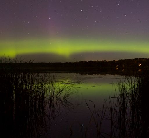
Auroras were *not* in the forecast this weekend. Nevertheless, "they're baaaaaaack," reports Bob Conzemius, who saw the Northern Lights on July 26th over Grand Rapids, Minnesota see http://spaceweather.com/ . This is a consequence of WeatherAction's 24-26th July R5

Piers says:  "The R5 pair 22-23 and 24-26th and related detailed forecast was very successful on the Sun, Sun-Earth Connections, Earthquakes, Europe and USA weather and successful in delayed and shortened (but intense when they came) aspects of Britain and Ireland weather, but there were problems there - see below. 
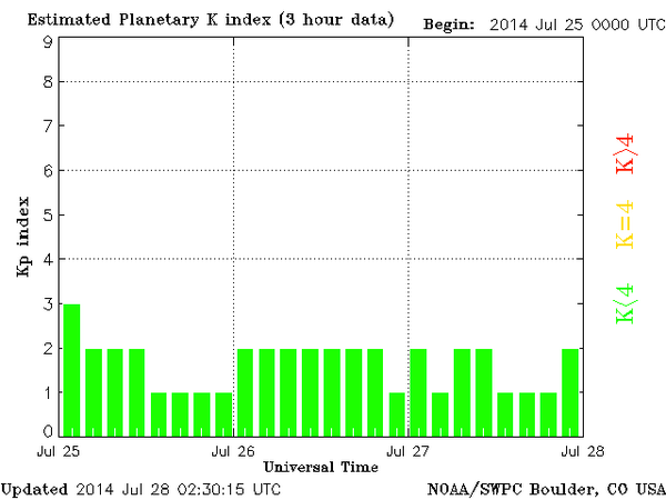
Geomagnetic direct effects (K graphs) were low but present - against a very low background - and tailed off to a lower level on 27th.
Embedded image permalink

Nevertheless an M6.9 quake (equal strongest this August) was witnessed - see below. This confirms the general point that there is more to WeatherAction SLAT (Solar-Lunar-Action-Technique) Red Periods than only events on the sun or what is directly apparent as geomagnetic activity (which is noise in the Earth's magnetic field) but they are also related to invisible Solar-wind-magnetic connectivity effects. Common standard Sun-Earth parameters are incomplete and inadequate as describers of total sun-earth effect. This is not surprising because they have grown over the years simply as reported parameters just because they were things which could be measured.

What happened to expected frontal penetration / Jet stream shifts around Br+Ir?
The continuing High blocking to the East in the face of a double R5, led to greater heating (as we warned in update comment), not less, and it is only now that the R5 period is ending that the forecast temperature especially detail is coming back on course. It appears there ia a greater tendency to cut-off-high blocking type events (particularly Br+Ir) in Mini-Ice-Age, also termed Wild-Jet-Stream-Age, more advanced (generally very low solar activity) stages. THIS is leading to further advances in SLAT. 
Note such Special COH effects will not always mean heat - in fact mostly the opposite - and corresponding longer fetches of air from Arctic regions in other places and times mean EXTREME cold  as in reports we have had from readers about the Ural mountains in Russia, Australian snow and of course the continuing offset polar vortex and notably cold weather in N/E USA - matters largely suppressed by the hiers of Goebbels who run main-stream media.

Co2-warmist charlatan Science deniers, who pass as 'experts' on BBC and Al-Jazeera, are reading this and we know it will give them confidence to continue copying our warnings of extremes (because they know they work) and claim when they come they are something to do with their Co2 story. 
We know and they know that what they are doing is a brazen goebbels-esque lie. 
They admit their models havn't a clue as to why the jet stream is behaving beyond their comprehension - and shows ZERO response in their models to CO2 increases. They know it's not Co2, they know their theory has failed in all aspects - ie evidence-based honest science. They know they have taken to modifying* temperature data across the world on an industrial scale while real experiences (increase in snow as oposed to its ending in Brit & Ireland; floods rather than droughts, massive hail which is a recognised MIA signature, etc) deny all their claims. 
[ *http://www.telegraph.co.uk/earth/environment/10916086/The-scandal-of-fiddled-global-warming-data.html;  http://www.weatheraction.com/docs/WANews14No11.pdf 

The Co2Con charlatans, data fraudsters, science deniers and bishops of the Co2-warmist religion will get their Judegment Day and come-uppance.


July 26th Loads more thunderstorms USA (see twitter feed) 
Scotland getting hit:  
Thunderstorm passing over one of static weathercams. See time lapse>  http://www.fifeweather.co.uk/index.php/weathercam

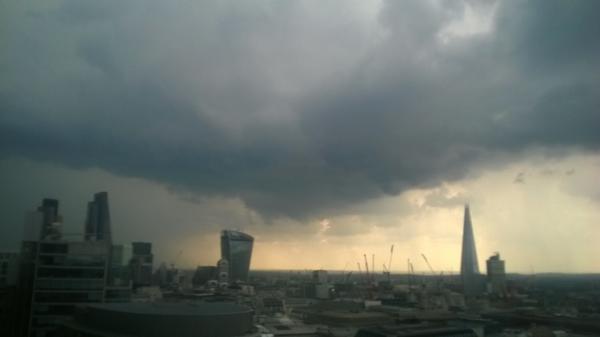
July 25th afternoon London Thunder hit in MO Yellow warning of 2 1/2 hr ahead. 
CONFIRMING WeatherAction advice that MO-TV would underestimate intensities / events in this R5 period. Pic below. A rail facility in Surbiton was struck by lightning causing very extensive delays on trains from Waterloo. See @Piers_Corbyn twitter feed and Reader Comms below.
Mean looking thunderstorm over London @dannyctkemp 

July 25 R5 period 22-26th Major thunderfloods + cool N/E USA AND terrible N heat and Wild-Fires S/W as forcast by WeatherAction confirmed (see more in News below)
http://www.weatheraction.com/docs/WANews14No32.pdf

These despicable charlatans, fraudsters and desecrators of science and all their hirelings will get their come-uppance. 


July 23/24/25 Latest R5 News - public, please pass on
On 24 Jul 2014, Bob Weber, N Mich USA subscriber wrote: {Reader Comm below}
"Piers nailed it again! Big drop in temps starting in northern midwest states over past day and a half has spead out southward. Most areas in US now colder than a few days ago. The moon that had delivered a nice warm blast a few days ago on it's last northward peak is quickly pulling the fronts southward with colder air behind. 
There was a long line of thunderstorm-lightning activity in the US last night that stretched from Texas to Maine, now out in the Atlantic. From http://iceagenow.info/2014/07/doomsday-hail-decimates-potatoes/ ,  6 inch hail wasted Russian town for 5 minutes late July 22. Can't wait to see what else happens in the next few days......"

http://www.weatheraction.com/docs/WANews14No32.pdf  (as pic above)

The first R5 (~22-23rd) of this double R5 period has been well confirmed both sides of the Atlantic - at least in USA and Central and S/E Europe while effects have been partly blocked in Britain & Ireland. The second R5 (~24-26th) looks set to hit hard in all parts predicted especially later / in slight extension of the period.
There has been the usual, solar geophysical, earthquake, cyclogenesis & Tropical storm extra development in this period (see below) 

USA  Severe thunderstorms, floods and large hail in North/East & SouthCentral USA - in areas forecast by WeatherAction - and including the sweep south of much colder than normal air; giving extensive power outages, floods, wind damage, giant hail and airport disruption - see twitter feed and eg:- http://www.accuweather.com/en/weather-news/live-blast-severe/30837609 

Europe  Extensive major thunderstorms especially South & SE Europe in regions warned by WeatherAction - see (early hours of 24th): http://www.sat24.com/?ir=true&ra=true®ion=eu 
 
Britain & Ireland For 23rd - when we had originally expected rains and thunder to get underway - there has been some noted increase in cloud beyond expectations of TV Met forecasts (see eg Reader Comms) in parts but rather like 15-17th (R4) the main active lows have been (initially) blocked in the Atlantic and heating maintained in S/E in the early part of the (22-26) forecast period. 
The held back Low attack is INCREASING HEAT in Br+Ir especially central & East England for a couple of days delaying the rain+thunder action in the forecast before a very violent thundery breakdown - see 'WHAT NEXT?' Below

Tropical Storm extra development
=> TD2 (Atlantic) formed and developed in this period   http://weather.unisys.com/hurricane/atlantic/2014/TWO/track.dat
=> Typhoon Matmo (W Pacific) ramped up from T1 to T2 in the period on 22nd   http://weather.unisys.com/hurricane/w_pacific/2014/MATMO/track.dat  just before hitting Taiwan when it weakened http://weather.unisys.com/hurricane/w_pacific/2014/MATMO/track.gif 

Coronal Holes: 23 Jul 14       Coronal Holes: 24 Jul 14
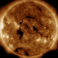
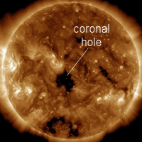
         
 Isolar and Geophysical terms. There is not a very large amount obvious on the sun. However note R periods eg R5, R4 are not just about Sun but also about Sun-SolarWind-Earth magnetic connectivity. Solar-Geophysical aspects of this R5 so far
(i) A Coronal hole is becoming/became Earth facing on 24th - see pics of 23rd and 24th (added later) from 
http://spaceweather.com/archive.php?day=23&month=07&year=2014&view=view (choose date)
(ii) There has been some uptick so far in Geomagnetic activity (same link)
(iii) An M6.9 (2nd M6.9 ie Largest= Quake this month so far) struck on 21st 94km NNE of Ndoi Island, Fiji 15.54GMT (within half a day of the 22-26th period) http://on.doi.gov/1niZPww 

WHAT NEXT?
Standard Met shows rain coming into Britain and Ireland later in the period 22-26th 
http://www.sat24.com/foreloop.aspx?type=1 which is now predicted to be wetter than had been expected before by standard Met. Due to the R5 the actual rain will be even more intense than this suggests and will be accompanied by major thunderstorms, large hail and likely some tornadoes.

The delay in effect may be interpreted as a Partial Cut Off High (PCOH) effect whereby the initial effect of the R5 is a High pressure block which then gets (largely) knocked aside (subject of investigation)

WeatherAction Forecasts General News
Up to 30d ahead forecasts for Britain+Ireland, USA, Europe and 'RTQ (Red weather periods & thunder/tornado+Quake risk) for May have been performing well.

As we go further into Mini-Ice-Age circulation the JUNE (WOW), JULY(WOW!!) and August (Really?!) forecasts are, as might be expected, very interesting and important both sides of the Atlantic.

What Subscribers say
Many idependent reports verify WeatherAction's world- leading significant forecasting skill (see Forecasts =>Accuracy on Home page) and from time to time we report individual user Comments. Hear Saskia Steinhorst a Nertherlands Subscriber on WeatherAction Euromaps Forecasts:-

 "(re May)....It feels like the climate is like a ping pong ball, bouncing all over the place. Keeping track is hard and would've been virtually impossible if not for Piers' EXCELLENT forecasts! ..."

READERS COMMENTS & FEEDBACK RULES
THIS Site is DEFENDED SPACE - 100% Moderated and troll-free because of ongoing cyber flood attacks and to stop postings not of fair and honest intent and to engage in fruitful discussion..............   

Comments submitted - 45 Add your comment

On 31 Jul 2014, Gill1066 East Sussex (sub) wrote:

piers there is a problem when you click on Latest comment 31st July- nothing is there!
On 31 Jul 2014, Sean Malone wrote:

Can Eire xpect this heat aswell piers and did you give that quote to daily xpress or are they misquoting you
On 31 Jul 2014, stephen parker ( sub ) wrote:

Well gill 1066, all us 30 day subscribers need to do is read the express!
On 30 Jul 2014, Paddy (Aberdeen south, 130m elevation, sub) wrote:

Interesting day today, somewhat cooler with an often blustery W wind, 12˚C overnight and 14˚ at 7.30, occasional light showers from an intermittently cloudy sky. Got up to 24˚ nevertheless in the sunnier moments, so still a good day. 14˚ at 10pm, nights now noticeably drawing in.
On 30 Jul 2014, Richard Traut yearly sub Redcar wrote:

Nice publicity in the express for Piers i see ,nice to see you taken seriously by the media :) http://www.express.co.uk/news/nature/493781/SHOCK-WEATHER-FORECAST-
On 30 Jul 2014, Paul, Bedfordshire (Subr) wrote:

After a glorious fresher not day, suddenly the humidity is up with still clear skies and my weather widget on the phone is forecasting thunderstorms over the weekend, on cue. Out of curiosity was yesterday/today NSF/Q or something else? (as my forecast dosent say what 29/30 is, I would guess NSF/Q or low R. . Monday was certainly a hit for Piers R4. Meanwhile Breitbart reports some chinese scientists backing up piers "SOLAR ACTIVITY - NOT CO2 - COULD CAUSE GLOBAL WARMING, NEW PAPER SAYS" http://www.breitbart.com/Breitbart-London/2014/07/29/Solar-Activity-Could-Cause-Global-Warming-New-Paper-Says
On 30 Jul 2014, Bob Weber, N Mich USA subscriber wrote:

We had major thunderstorm activity in Michigan that Piers featured here http://www.weatheraction.com/docs/WANews14No33.pdf - our location is at the middle top edge of the Michigan graphic. Three low pressure centers converged around Michigan, bringing that rain and lightning. Lightning activity has been high across the US for the past week. Those three lows later merged into one deep low that later tracked into Massachusetts, producing a tornado near Boston. Long cold front arc now firmly established along eastern and southern coasts, with cool air filled in behind, widespread cooldown in place, as "super" moon tomorrow crosses the equator and continues transiting further southward for the next week. The solar counterforce is picking up now, SSN=160, SF=132 with small, unimpressive spots. Will we see solar flares this time around? Ours and others in area have gardens that started well under more intense sun, now spindly & low fruit growth from lack of solar intensity. Cool 60F.
On 30 Jul 2014, Bob Weber, N Mich USA subscriber wrote:

The double R5 saw Bt, the interplanetary magnetic field, go from days at 4nT to double at 8nT on the 25th & 26th, while Jupiter, Sun, New Moon, and Earth were within 1-2 degree orb, then dropping down to a low of 2nT now back to 4.4nT. The IMF is the solar wind + cosmic rays + particles accelerated off moons and planets. When the number and energy level of heliospheric electrons and protons go up, the IMF goes up, because Bt is the superposition of each particle electric and magnetic field, per Millsian theory, which is a vast improvement over the Bohr atomic model. See http://www.blacklightpower.com/theory-2/book/ get the book. Dr. Randall Mills correctly characterizes the entire periodic table using an orbitsphere model for the electron, which is comprised of an electric and magnetic field component. No, Dr. Bohr, your atomic model was not crazy enough! Mills is similar, yet different than Bohrs, see here http://zhydrogen.com/?page_id=350 & http://physics-edu.org/wavenature.htm.
On 30 Jul 2014, Nigella wrote:

Another gorgeous day here in East Berks. Wall to wall sunshine, 24 degs, not humid, light breeze - oh how I wish I were out in it for more than just the walk to get some lunch! Bit lost on the forecast but enjoying the weather for now.
On 30 Jul 2014, Lorraine Lister (sub) NZ wrote:

Here we go again http://www.businessspectator.com.au/article/2014/7/29/science-environment/nzs-southern-alps-have-lost-third-their-ice This was on our TV news tonight with suitable doomsday scenario comments.
On 29 Jul 2014, Paddy (Aberdeen south, 130m elevation, sub) wrote:

15˚C at 7.30, cloudy but with the sun breaking through on & off all day, sunny evening. Max temp 27˚ but under cloud cover it felt quite a bit cooler, back down to 15˚ by 10pm. == Interesting tornado story: a business acquaintance of mine from near Edinburgh told me that recently when it was a lovely day and the girls from the office were going to have their lunch outside on the lawn, they put their lunch boxes outside & then went back in to get the chairs. When they came out again, the lunch boxes were no longer there but 20 yards away; they had heard a rush of wind but didn't quite realise what it was until they came out, i.e. a small tornado. On another occasion, the office windows were being bombarded by the gravel (5mm ø) which was being picked up by the passing tornado they could see through the windows. Unfortunately I forgot to ask exactly when that happened, but it was certainly within the last month.
On 29 Jul 2014, steven glossop wrote:

Hi Piers, a very interesting August forecast coming up. One question i would appreciate if you could answer. Why did the maunder minimum and sporer minimum reach even lower temperatures and last longer than the Dalton minimum ? Keep up great work..
On 29 Jul 2014, Alister wrote:

Lightning follows the easiest electrical path, but this is not always the most direct route. IIRC, the difference in charged regions sets off 'feelers' as the potential difference attempts to dissipate via a multitude of paths. The action has already commenced even before the strike is seen. The movement of air, differences in moisture, objects on the ground etc influence the direction the final visible strike(s) takes. The probabilities of the strike taking any one particular route quickly narrow down once a strike is under way, the rush of current ionizes the air around it, 'burrowing' its way along the best path and the strike becomes visible. Having been on moorland during a storm, I have felt the sensation of being briefly statically charged, only for the actual strike to make ground about a kilometre away, thankfully.
On 29 Jul 2014, Russ subs NE Derbyshire wrote:

cont`d .... oops! Ran out of room. > Why would lightning hit a mature tree at the side of a lake...why not hit the lake? A scientist might say that water is a bad electrical conductor with a resistance of many thousands of ohms. Ok then, why should we not handle electrical appliances with wet hands? Shouldn`t the water act like rubber gloves and insulate our hands? Shouldn`t swimmers be safe as houses? Why does lightning hit the sea if water is such a poor conductor? And why were we taught at junior school that water and electricity are dangerous bedfellows? Why are we taught such rubbish and have to spend the rest of our limited lives trying to find answers that are logical, rational and above all proveable? Why does lightning hit a tree in the middle of a forest instead of the tallest tree near the top of the same hillside? Path of least resistance remember. Tree higher up is a shorter path to the ground plus its an identical tree to the one which was struck...
On 29 Jul 2014, Russ subs NE Derbyshire wrote:

Logic exercise. Read this article about lightning from grandmother Beeb! >> http://www.bbc.co.uk/news/blogs-magazine-monitor-28521789 << Several contradictory points but I`ll focus on the biggest. It say`s that, according to NASA (so it must be true), lightning is far more likely to hit land than the sea. They go on to say that lightning`s massive electrical charge flow will always find the path of least electrical resistance. So why does it keep striking land when earth has a far higher electrical resistance than water, especially the saline seas. Also, if lightning `always` follows this rule, then why does the vast majority of lightning occur across the leading edge of a storm front? Very few lightning strikes occur during heavy rain, and these are usually cloud to cloud. If it`s raining on you, it might not be raining 500 metres away where you just heard the lightning. If lightning goes down to earth then it should always hit water; easiest path; best conductor etc.
On 29 Jul 2014, Russ subs NE Derbyshire wrote:

Want something stupendously amazing to read? The future generation of electricity may be way different to anything you could ever imagine....read on >> http://www.iflscience.com/technology/how-drop-seawater-graphene-generates-electricity <<
On 29 Jul 2014, Gill1066 East Sussex (sub) wrote:

Ditto Stephen Parker. Us poor farmers who can't afford the luxury versions have to also wait till Thursday. In fact as the 30d is never released until Midnight (usually it seems) it is the first of the month before we get it - slightly unfair - it could be released at 6pm on the last day- are you reading this Piers? Back to Sunday / Monday. My MO 5 day forecast which was on my screen all day Sunday until Monday morning showed no showers or rain that day. Au contraire - It tipped down in the afternoon. The rain (not shower) was so heavy I stayed in the polytunnel with the dog for 45 mins till it stopped. It rained again later on, - in fact enough to soften the ground for me to get some plants in. My son who was over near Rye had his last moto-cross race cancelled as the ground conditions were too dangerous to race. Then yesterday for am - MO show thunderstorm and some rain for here. Guess what ZILCH! it all fell in Hove about 30 miles away. So much for MO accurate forecasting!
On 29 Jul 2014, Nigella wrote:

It is another lovely sunny day here in East Berks with temps expected up to 27 degs. After the rain in the early morning yesterday, the rest of the day was dry, other than a very brief shower at 3pm, mostly overcast but uneventful here. It was a little fresher last night with low temp of 13.5 degs, so our household all slept better than we had done for about 2 weeks. Lorraine, I recall hail with most big thunderstorms, which tend to be more summer occurrences than winter here in the UK - so I'm guessing it is not that unusual. Bit anecdotal rather than scientific - I'm sure someone will be better informed than me.
On 29 Jul 2014, Lorraine Lister (sub) NZ wrote:

I read that Dr Peter Inness of the University if Reading believes that there is nothing unusual about the storms that you're having in the UK. Yes, a build up heat in summer can certainly lead to thunder storms and I remember this when I lived in France years ago. What I don't remember when I grew up in the UK was summer storms with hail - this is a typical mini ice age occurrence and exactly the type of extreme event that leads to crop failure as can be verified by looking at the past records in booty.org or Marusek's early weather events data. Sounds like another warmist explanation for what isn't a normal summer event.
On 29 Jul 2014, Saskia Steinhorst (Neth.sub.) wrote:

@Paddy - Thankee, kind Sirree. As you can see I have re-attached it ;-) OT: weather here is quite the contradiction with the rest of the country. Far upper part of The Netherlands was sunny and warm today, while the rest of the country was inundated in masses of water the like of which had not been seen before in a single day. Reports state that locally TWO HUNDRED MM of water fell within 12 hours. Did Piers warn us? YES!! Right after the period of "thundery showers, warmish, mostly cloudy" ending on July 26th he predicted "wet, windy, major thunderstorms, large hail, cloudy" for the next period. The dividing line of the region influenced by this weather predicted by Piers coincided almost 100% with the flooded regions in the country. The wet came, the thunderstorms came, and the wind is here as well. So far my subscriptions to WA have been "a lot of bang for my buck" as far as I'm concerned.
On 28 Jul 2014, Paddy (Aberdeen south, 130m elevation, sub) wrote:

Splendid day today, 15˚C at 7.30, somewhat cool NW breeze but as the sun rose, temps kept creeping up, by 11am it was already 26˚, today's high. S'ly breeze in the afternoon. Apart from various cumulostratus clouds there were some lovely cirrus formations aloft in the afternoon, always a graceful spectacle. 15˚ at 10pm. == It is remarkable how localised weather can be, as reported by Steve Dorset; I don't know whether that is a particular feature of the run-up to the LIA. A friend reported coming back from the north to Aberdeen last night via Inverurie, where she had to stop the car because she just couldn't see anything anymore in the extremely heavy rain, 20 miles further south we had nothing. == Saskia, you seem to have dropped a K - 'is that your K, madam? I found it lying in the street' :-)
On 28 Jul 2014, Carl 30d Subscriber wrote:

Wow Piers you done it again!!!! even if you said it would be delayed.Nothing here with rain but Wow Worthing and West London torrential downpours and huge floods and again the MetO never even saw it coming.As for the rest of July dont knock your forecast Piers as you did mention as a MAIN UNCERTAINTY that the amount of blocking to the East of U.K and you are streets ahead at long range weather forecasting than the MetO will ever be!!
On 28 Jul 2014, Maria 45day sub somerset wrote:

Thanks so much for the august update, have sent it to my two children as they have young children and need to take urgent measures. My stomach is already churning
On 28 Jul 2014, Russ subs NE Derbyshire wrote:

I`d like to clarify a point I made earlier about charges increasing in voltage. A voltage is the potential electrical energy between two points. On earth, the voltage between the ground and the head of a 6ft man is around 200 volts but at 50km up in the atmosphere it reaches around 300,000 volts. So the voltage can constantly change in an electrical field and in the near sun environment is doing exactly that. The mainstream will state that the earth`s magnetic field has flipped south and is allowing in the solar wind. A better way to describe this event would be to say that the field has `aligned` with the incoming charge, instead of opposing and cancelling it. These cracks in the field (which term NASA uses) is simply misleading. The field doesn`t split in two, instead, a region, often very large, will have a sudden voltage drop, due to the cancelling effect of incoming charges, so the magnetic field only appears to have a gap. This is where we get the magnetic reconnection fantasy.
On 28 Jul 2014, richard [subs east mids] wrote:

having watched the various vids of those storms i hope they miss us. They made a right mess. Reminds me of southern France short sharp flooding storms down near Biarritz When did Meto put their warnings out about them? The usual 2 hrs before?
On 28 Jul 2014, stephen parker ( sub ) wrote:

Ah, us poor relation 30 day subscribers dont get the news!, and its only 4 days till august.
On 28 Jul 2014, Saskia Steinhorst (Neth.sub.) wrote:

WETTEST DAY EVER in Dutch meteorological records!!!! Today anywhere between 130 and 170 mm (!!) fell at specific locations! "Old records have been PULVERIZED" says local weather man Marc Putto
On 28 Jul 2014, Sasia Steinhorst (Neth. sub.) wrote:

Images of flooded areas: Amsterdam http://bit.ly/1pvgzO2 - http://bit.ly/X30iJi - http://bit.ly/1uyrzSP - http://bit.ly/1tgYpGn - http://bit.ly/1xo7gDD Utrecht http://bit.ly/1pviphR In Tilburg police broke into a house which was flooded with 30cm of water in order to save a dog http://bit.ly/UFjNWt More from Tilburg http://bit.ly/1zlzzW5
On 28 Jul 2014, Sasia Steinhorst (Neth. sub.) wrote:

CODE ORANGE for provinces of Noord-Holland, Utrecht, Noord-Brabant and Zeeland!! Due to rain. Rained all night until early morning here, but we're lucky ... the western part of The Netherlands - provinces of Zuid-Holland, Zeeland and West-Brabant - is FLOODED, so much so that highways have been closed off! Schiphol Airport has had to delay flights as taking off/landing was impossible! Reports of 110mm of rain in barely 12 hours (Alphen aan de Rijn) flooded subway in Amsterdam (http://bit.ly/1uyqhau) flooded tunnels; 16.000 families cut off from electricity due to flooding in Tilburg (West-Brabant).
On 28 Jul 2014, Maria 45day sub somerset wrote:

WOW, 2 days late BUT look what happened at the tale end of double R5 http://www.dailymail.co.uk/news/article-2708224/Used-roads-rivers-hail-Storm-described-zombie-apocalypse-brings-chaos-morning-rush-hour-British-cities-thunderstorms-flash-flooding.html
On 28 Jul 2014, sarah wilton wrote:

Awesome storms this morning in parts of Southeast England. http://www.bbc.co.uk/news/uk-england-sussex-28520520
On 28 Jul 2014, Nigella wrote:

Obs from East Berks. Sunday still very warm with a high of 26 degs & dry all day, although it was quite cloudy at times. This morning, we had some very heavy rain from 6.30am which turned to showers until 8.30am and now it is blue sky & sunshine again. Looks like there may be more showers later though moving in from the East (again!).
On 28 Jul 2014, richard [subs east mids] wrote:

If we divide up the year into 4 periods marked by the solstices and equinox then i would expect more cut off high during the 2 settled periods ie 21june-21sept and 21 dec-31 march while the other 2 periods are transitions so more unstable? A meandering jet stream means you can get 'stuck' for long periods e.g usa winter where they still had ice on lakes in june [longest for 40 yrs -since records began Jan. 1 to April 1 averaging 7 degrees below normal]
On 28 Jul 2014, Clive wrote:

Cut off highs. If we have more cut off highs in Britain and North west Europe it many result in our summers becoming more settled but these highs in the winter could result in the frequency more extreme cold events. It will be interesting to see what will happen in the winter coming up if cut off highs start to block the patterns. Cut off highs to the west and north west of us were a major feature in June. If this was to happen in January 2015. We would be in a very prolonged north to north easterly flow coming down from the arctic from a full month and that would mean a month of freezing conditions.
On 28 Jul 2014, Richard Pinder wrote:

Part (2): The dogma of speculation, assumption, consensus, belief, scepticism and denial where important to the interviewer, as were computer models, but Lindzen said that there should be some warming according to the Greenhouse effect, as he still seems not to have found the alternative to the failed Arrhenius method, as he said it should work for the Earth, nothing was said about the carbon dioxide atmosphere of Venus. So nothing new, and Lindzen seemed to be where I was ten years ago.
On 28 Jul 2014, Richard Pinder wrote:

The Al Jazeera Richard Lindzen interview was censored for the first two repeats but finally I found it recorded on the third repeat at 0200 yesterday, it may be repeated at 07.00 today? Watched it at tea time. No mention of Solar influences or observational changes to the Earths cloud albedo (which could help correct all those computer models by replacing assumptions about carbon dioxide and aerosols, with facts), or Weather from the Sun, first postulated two hundred years ago by William Herschel when he found that the price of grain was inversely correlated with the sunspot number, and still no one in the room had caught up with Herschel, even implying a contradiction to correlations found by Herschel as regards future food supplies. And as usual, no one brought up the core basics, such as how to calibrate carbon dioxide warming. No mention of correlations pointing to answers.
On 28 Jul 2014, Sasia Steinhorst (Neth. sub.) wrote:

Apparently Stockholm, Sweden has had quite a bit of rain as well, gathering from this post on a site called Imgur: http://imgur.com/gallery/sxHeV3P Over here quite the opposite was the case, as nearly 50 villages in our region found themselves without tap water for nearly an hour. Fortunately the problem was solved quite quickly, but imagine what would've happened if this had taken place during one of the hotter days and had lasted longer than it did! Here's a map I put together of the affected villages: http://t.co/dUYparmCGd - OT: temps over 25C again although more overcast than previously. NO rain again in our area, hopefully some will arrive soonish.
On 27 Jul 2014, Paddy (Aberdeen south, 130m elevation, sub) wrote:

Judging by the puddles roundabout, there was a good splash of rain overnight, not as much here as further west as shown on the radar, and overall there was a cooler feel to the day. 13˚C at 7.30, but then warm sunny morning, rising to 26˚ by 11am despite the N'ly breeze. Some good showers around midday, then sunny & dry again, the wind had turned into the SE for a while. Still by 9pm, clear sky & still 17˚ on thermometer, though it felt cooler than that. We've been lucky that the Scandinavian High had kept those Lows out in the Atlantic, the one that got through overnight brought welcome water to the dry ground. The fact that it's been dry for so long also has its good side: much less weed growth.
On 27 Jul 2014, Maria ( Ireland sub ) wrote:

Some light drizzle this morn. cooler daytime temps of around 17-20, sun came out @ times though mostly overcast, feels cooler tonight with a moderate N-NW breeze closed the windows down earlier for the first time in a few weeks, nice to have some fresh air but could still do with a good soaking here....
On 27 Jul 2014, Piers_Corbyn wrote:

GREAT COMMS ALL These are interesting times! August will be exciting and I urge all to get 45d Br+Ir now and of course Eu+USA 30d now gives July Free --- RICHARD LINDZEN Oxford interview Repeat I was there back in March in invited audience and made a comment-challenge to warmists in discussion which was lively. I get the impression this was all/largely cut-out because the wamists were so utterly pathetic. I didnt see this repeat. Can anyone comment on it and say what if any discussion was reported. Remember who funds AlJazeera. Thanks
On 27 Jul 2014, Gerry N Downs 600ft 45d wrote:

The Al J Richard Lindzen programme exists as I recorded it last night. It may be on again as they need to fill their 24hr broadcasting. Bright with sunny spells this morning. Fresh with a good breeze again. Temps will pick up if the sun burns through the cloud but the breeze will be nice.
On 27 Jul 2014, Russ subs NE Derbyshire wrote:

The energy levels of lightning storms change as the solar wind increases and the earth`s magnetic field changes shape. I don`t like all this talk of flipping and swapping. A magnetic field is created by moving electrical charges. You can`t have one without the other. As electrical charges increase in voltage, then the magnetic field strength also increases, the charge creates the field, the charge is the field. The earth`s field changes in it`s potential, it`s voltage. The polarity can change, depending which charge is dominant, positive or negative, making the magnetic field seem to magically flip. They (NASA), measure the field, see it`s changed` but aren`t sure how, so they stick dumbed down labels on everything, which helps no-one. If the earth`s polar field seems to flip and the potential across the earth`s current sheet goes negative enough, then you`ll see fireworks...but will be worse for anything facing the sun...so many theories....only one is correct!
On 27 Jul 2014, Russ subs NE Derbyshire wrote:

Richard (subs E Mid`s) re: "...with convection thunderstorms and heat plume storms from the south..." ...... When the weather is hot, humid, maybe the Met Office have issued a forecast for fine weather but with the possibility of heaver showers (that`s 100% of a UK summer covered), and it looks as though a thunderstorm will appear at any minute, well, just take a moment to check on Piers forecast and spaceweather.com to see what effect the sun is having. Day after day you`ll see perfect weather for a storm, yet every day, nothing will happen. Note how the lightning across Europe has abated since the R5 has ended? The large round coronal hole, just like a cannon barrel, which has been pointing straight at the earth for the past few days, supplied the majority of the lightning we`ve witnessed leading up to the weekend. Also note that the side of earth facing the sun is paramount. If the solar wind increases in speed with America pointing at the sun, then the US will get the full effect.
On 27 Jul 2014, Steve,Dorset.UK. Sub wrote:

http://www.bournemouthecho.co.uk/news/11367949.Storm_takes_Dorset_by_surprise_and_causes_flash_floods/ This storm missed us by a mere 700 mts or so, we had a few heavy rain drops but we could see the storm going along the coast as we are quite high up here.this happened the outher day as the link explains have a look.
On 27 Jul 2014, Steve,Dorset.UK Sub wrote:

I must have struck unlucky for me as my comments must have just happened when piers started a new page of comments, never mind you will never know what gems i had to say. Nice weather.