On 27 Jul 2014, Steve,Dorset,UK.sub wrote:
A thought ... In the papers today they are saying that aspirin is bad for the heart and could cause heart problems in some, this is typical of science they go around spouting that this is good this is not good but it just goes to show that the debate is not over on aspirin as with The global warming religion. And this sat in the garden in my shorts and t shirt having a cup of tea with the ipad on my lap annoying you all with my thoughts have a good day. 8.30 am sunday
On 27 Jul 2014, Steve,Dorset,UK. Sub wrote:
Here in Dorset we have had a good spell of hot weather which has been wonderful, We had a thunderstorm along the coast which gave a flash flood for some but missed us by only some 700 yds or so, 4" of water on some roads spots here. So you can see the nature of thunder very localised. Enjoy this weather.
On 27 Jul 2014, richard [subs east mids] wrote:
22-26 July 2014 forecast review - the Atlantic lows were blocked and sent north by the jet off Ireland and it was mainly fine and hot with convection thunderstorms and heat plume storms from the south that could be dramatic with heavy localisied rain and flooding. A weak low came in on the night of the 26/27 centered on NW Scotland and a sprinkle of rain did pass over the rest of uk . Any intensification was either of heat or of the thunderstorms. "Very wet and windy in all parts" with " cold to cool" didn't happen so 0.2 out of 1 making a cumulative 5.2 our of 7 for July.
On 26 Jul 2014, Richard Traut yearly sub Redcar wrote:
Most unusual, r5 periods ,not had any effects on my neck of the woods this month so far ,mainly warm and sunny ,maybe its delayed more than the +1 or 2 days ,it has been a better overall month weather wise (a proper summer)than even last july 2013,certainly here we have missed out on thunderstorms,heavy rain etc ,hopefully some rain is due tomorrow as the gardens need it thank you,Richard.
On 26 Jul 2014, Paddy (Aberdeen south, 130m elevation, sub) wrote:
Steve in Fife: we had scorchio weather until about 6pm, though the sheet of clouds moving in from the west could be seen from mid afternoon, moving very slowly towards us. There was a sharp bit of rain around 7 which lasted about 20 mins, not much volume of water though & no thunderstroms. MO says heavy rain overnight from the bulk of that front which is now over your parts but sunny with clouds tomorrow. Today, already 16˚C at 7.30am rising pretty rapidly again to 27˚ with a nice S breeze, lots of cirrus clouds in the morning giving milky sunshine, still 18˚ at 9pm.
On 26 Jul 2014, Maria 45day sub somerset wrote:
http://www.aljazeera.com/programmes/headtohead/2013/06/201361311721241956.html
On 26 Jul 2014, Steve (sub) wrote:
Today started just like the last phew! but by early afternoon - kaboom! Many thunderstorms in the Forth Estuary area and north. Standard met services still showing a hot/sunny day. Watched them on radar north of here just appear as if by magic. (Now I wonder who predicted that?) Reached you yet paddy? We also saw that cloud lab programme - interesting the comparison of polluted and non-polluted clouds and their properties: upshot is that we have had cooler/calmer weather since the industrial revolution and are returning to normal since clean air acts in many countries. Add that to solar/lunar influence and.... Also notice "Ice Age Now" NOAA says twice as many coolest ever readings worldwide as hottest ever. They also report on Dr Piers' well-forecasted hot west/cold east USA and the icebergs on the great lakes - won't see any of that on mainstream sheeple-media!
On 26 Jul 2014, Gerry N Downs 600ft 45d wrote:
Al Jazeera Head To Head - the Richard Lindzen interview was on at 1300 today but is repeated at 0200. I have programmed it in via the guide which has it listed.
On 26 Jul 2014, Richard Pinder wrote:
Al Jazeera is advertising a program called Head to Head, with world leading Atmospheric Physicist , Professor Richard Lindzen, at the Oxford Union, recorded in March of last year, on his view that concern about global warming is alarmist nonsense. The program seems to be a repeat of series one, but the program seems to be censored on Al Jazeera English on British freeview channel 83, at the advertised times? Does anyone know what is going on, why is it being censored?
On 26 Jul 2014, Nigella wrote:
Another hot day in East Berks at 29 degs. Other than the hour of rain yesterday afternoon, there doesn't seem to have been much breakdown in the weather yet. Hazy blue skies and a few puffs of cumulus.
On 26 Jul 2014, Maria ( Ireland sub ) wrote:
Top temp in Ireland yesterday was around 27.7 in Oak Park & Castlederg the coolest was 19.3 at Mace Head in Western Connemara, Dull drizzly & 20 deg. here today humidity around 83 % and 1018mb pressure approx.with a w breeze....
On 26 Jul 2014, Gerry N Downs 600ft 45d wrote:
...The removal since the 80s of particulates in atmospheric pollution has increased solar brightness by 80% and temps by 20%. But, of course, the sun still can't have caused the warming. LOL And this is another element not in the global warming models that fail to show temps flattening out. To a lot of us non-climate scientists it is another 'no, really' moment. Block the sun with stuff and it is less bright and warm. Remove it and it is brighter and warmer - just like when the planes stopped flying for 3 days, the vapour trails disappeared and it got warmer, and yet clouds are modelled a positive feedback.
On 26 Jul 2014, Gerry N Downs 600ft 45d wrote:
Further showers in London during the afternoon. Evidence of heavy rain on The Downs by the flooded drain outside the station. Rain petered out during the evening - not as humid as before. Blue sky with some clouds on a good breeze that seems to be N to NW. Sat24 suggests it should be N to NE but then veering towards the west so maybe they are behind reality. Jonathan L- it is not a 'coronal mass injection' indicated on Spaceweather but an earth facing coronal hole that it likely to increase the solar speed and possibly its density in the next few days. It is also 'ejection' as it comes from the sun. Lorraine- Spaceweather are referring to earth-facing activity being low to non-existent especially at what should be solar max. There have been CMEs on the far side which although not earth-directed can affect us. As usual, NASA's concern for lack of solar activity is at odds with their claim that it has no effect on us. New report shows pollution controls cause of warming & brightness...
On 26 Jul 2014, Russ subs NE Derbyshire wrote:
Piers...... Can we have some rain please? Our little westie is having trouble finding running water to drink whilst out walking. All the hundreds of little water courses have dried up. It`s like a desert out there folks!!
On 26 Jul 2014, Russ subs NE Derbyshire wrote:
Some of the after-effects of a WeatherAction R5 >> http://www.bbc.co.uk/news/uk-28498531 << Another way of proving that lightning isn`t a simple case of rising and falling air pockets in clouds, is this. Monitor Sat24 through the day and watch how the lightning strikes suddenly appear over a vast area almost simultaneously. This has to be an outside influence as the charge differential is from the top of the atmosphere to ground. Any localised voltage differences are arbitrary and would not be able to create the observed pattern, covering many millions of sq/km, in such a simultaneous fashion. Clouds will `tend` to equalise charge through cloud to cloud discharges (local component) but this couldn`t create such massive displays of ground/space/ground full blown lightning strikes, across areas separated by many thousands of miles. Visible waves of strikes should follow solar wind flux levels, as the relativistic particles change the charge potential in the earth`s current sheet..Bob?
On 26 Jul 2014, Shaun (Wales) wrote:
@Lorraine, dont know about very active, still stating low level activity and likely to continue as very low activity according to NASA, low obviously not zero activity but still low and nor very active
On 26 Jul 2014, Lorraine Lister (sub) NZ wrote:
The double R5 periods have been relatively quiet in NZ. Some wintery weather but nothing unusual for July. Compared to the northern hemisphere reports we've got off very lightly this time.
On 26 Jul 2014, Geoff Hood Sub 45d wrote:
well, thanks piers,your R5 was correct , i have been camping near bournemouth and told my wife we will need to get back home maybe thursday 24th but definiltey on friday 25th, well took some convincing as the MetOlast night said a few thundery showers for Friday but wepaked up and left bournemouth at midday today( 25th), WOW what was that storm we met on th M3 and later I undertand hit the purbeck penisular and the campsite we had been at has been swamped with a flash flood, The campsite was full as they all beleived the met O warm and sunny and perhapsachance of ashower
On 25 Jul 2014, Lorrane wrote:
I read that the sun went completely quiet about 4 days ago and now it's really active what an amazing star it is
On 25 Jul 2014, @Piers_Corbyn - teitter wrote:
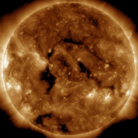
THIS R5 AND WHAT NEXT JONATHAN L HUNT - Thanks for your comm! Yes it is interesting how we have R5/R4 bunching around end of this month. AS ALL SUBSCRIBERS WILL KNOW [Now there IS an idea for the 80% of non-subscribers who visit WeatherAction site; order Aug now & JULY is FREE!] there is MORE to come this month. The last weather period states (in B+I, Eu, USA etc forecasts) Solar factors: NSF 27, R4 28-29, R5 31 - 2 Aug. Interestingly it shows the timing you mention is suggested by SpaceWeather.com for a Coronal Hole fast solar wind Earth hit 28-29th. I would stress however be careful over details. There is more going on than visible and quite often SpaceWeather implied effects may be a bit earlier than their projections AND when they say not much is happening, like for MetO forecasts, if it is in an R5 or R4 you are likley to suddenly get more. Notice eg that Coronal hole has got a lot bigger - obviously 'up to something'. It's NOT Co2" I must remind #Co2Con #ScienceDeniers
On 25 Jul 2014, Paddy (Aberdeen south, 130m elevation, sub) wrote:
Another scorcher today, starting off with 16˚C at 7.30 and already 22˚ by 9am, rising to 27˚ by about 11am, wall to wall sunshine & just a few cumulus towers to the west. Our neighbour managed to bale his hay on our bit, so good job that the R5 effect hasn't hit just yet; they've been lucky this year and managed to make a huge amount of hay. There is a good market for it round here as many people have horses, oily Aberdeen generates sufficient funds for that kind of thing. 15˚ at 10pm. == Craig: dewpoint appears to have been 14˚ today, got that from http://local.msn.com/worldweather.aspx?eid=555&q=Aberdeen-GBR Nice article about haar! We've had the experience in Sept 98 (I think) where 2 weeks out of 4 were greyed out. MO all over the place with their forcast, the heavy rain predicted for Saturday has now evaporated to mere light rain; how they can be so brazen in trumpeting their 'success' & 'accuracy' does point to complete doublethink.
On 25 Jul 2014, Steve (sub) wrote:
Last rain here was 3mm on sat/sun19/20th. Since then temperatures have increased from about 16 at the weekend to well over 20 with Wednesday just a bit lower but the last two way higher - mid 20s, then almost 30 today - scorchio! Skies usually some low cloud at first (off the north sea) but rapidly becoming flat, blue, calm-ish and desert-like with low humidity and stable airmass. A few very distant towering Cu today to break the monotony. Every time I drive from near Loch Leven to home by the Forth Bridge my car thermo shows a welcome 5-6 deg drop as I get o the Forth estuary (If ony I could work from home! - not built for prolonged heat)
On 25 Jul 2014, Jonathan L Hunt wrote:
Brilliant forecast for storm here in London today Piers! My work colleagues were very impressed and now believe in the link between solar activity and weather. I kept track of the evidence from the met forecast through the week and showed them. They were gob smacked when they saw the variations through the week and of the change as you mentioned for 9:30am this morning.
One question. Spaceweather.com is showing a coronal mass injection due 28th-29th. Is this different to the R5 flares or is this a third burst to come in a row?
Keep up the good work!
Thanks
Jonathan
On 25 Jul 2014, @Piers_Corbyn Twitter - WA Forecaster wrote:
LONDON THUNDER. PAUL; Thanks for your timely comm. The London thunder rain hit is late in our fc but nevertheless HERE in the period we warned 5 weeks ahead. JIM ALLENBEE; Your Comm against Paul re MetOffice indications of such hitting London is misleading and trollish. There were no Yellow (or more) warnings for this rain in the last few days untill 9.30am today, ie 2+1/2 hrs (one tenth of a day) warning - compared with WeatherAction 35days ahead ahead warning of such things likley in these few days. FURTHER WA also correctly stated that MO ~1d ahead fcsts (eg no warning) would (eg UNDERESTIMATE intensity in this period.
For info: The MO site http://www.metoffice.gov.uk/weather/uk/se/se_forecast_warnings.html said:
"Yellow Warning of Rain25 Jul 2014, 12:00
Issued at - 25 Jul 2014, 09:30
Valid from - 25 Jul 2014, 12:00
Valid to - 25 Jul 2014, 21:00
Heavy showers or thunderstorms are expected to develop locally this afternoon. Some torrential downpours are possible.......
On 25 Jul 2014, Craig M (@CraigM350, Berks sub) wrote:
Line of storms moving s/west passed in cutting across Essex down to Brighton and as far west as Newbury and disruption ensues. ====
http://www.itv.com/news/london/update/2014-07-25/delays-across-the-board-due-to-lightning-strike/ === http://www.itv.com/news/london/update/2014-07-25/hour-delays-expected-after-lightning-hits-signal-post/ === http://www.surreycomet.co.uk/news/11367292.Lightning_strike_at_Surbiton_causes_massive_train_disruption/?ref=var_0
On 25 Jul 2014, richard [subs east mids] wrote:
Looking at WA DEC 2013 forecast in the Archive [ against actual we see [quotes from Meto] "first storm of 5 December" + " A week of quieter weather then followed, " + "storm of 18 to 19 December" + "heavy rain and strong winds on 26 to 27 December and again around 30 to 31 December" were ALL forecast by WA. The only one WA missed was " storm of 23 to 24 December" but if its plus 1 day then WA got that one too. Maybe WA should send a copy of that report to the energy companies/media/etc? Meto say WA is just luck with no statistical significance while they claim/boast they get 6 days out of 7 right lol. Meto quotes from http://www.metoffice.gov.uk/climate/uk/interesting/2013-decwind WA DEC forecast from http://www.weatheraction.com/resource/data/wact1/docs/BI%201312DEC%2030d%20Update%20of%2045d%20Prod28%20Rel30Nov.pdf or look for 30day in archive EVIDENCE BASED SCIENCE FOR ALL TO SEE
On 25 Jul 2014, Maria ( Ireland sub ) wrote:
Cooler start 13 deg. @ 7.30 a.m.. Phew hot here 24/26 deg 58% humidity sunshine with occasional cloud for a few mins respite @ times, an excellent cloud watching day too whilst tanning, taking plenty of water and shade breaks, beautiful day happy kids and mum!-)
On 25 Jul 2014, Maria 45day sub somerset wrote:
Paul, Ian wow, saw it on lightening maps. Send some to me, please. No water butt water left and am melting, again. 30 in the shade. I need to drink a lot more. Got spuds up early today and all in now, stored for winter, back breaking job, was like a red lobster as I finished digging at 11.30. Husband picked them up at 3 and brought them in. Local grain in too, feel almost ready for hunkering down, ready for anything this winter
On 25 Jul 2014, richard [subs east mids] wrote:
The cost of listening to MetO "Ofgem has ordered energy companies SSE and UK Power Networks (UKPN) to pay an additional £3.3 million for prolonged power cuts during the Christmas storms. Maxine Frerk, Ofgems Senior Partner for Distribution said: While we recognise the hard work of the companies and their staff who were out working to reconnect customers during the severe weather, the companies could have done more to plan for the weather and keep customers informed. http://www.energylivenews.com/2014/07/24/energy-firms-fined-3-3m-more-for-christmas-power-cuts/ Pretty hard to plan for weather Meto doesn't even know about till water comes through the cat flaps? Ofgem doesn't seem to know Meto cannot warn infrastructure in time for them to plan anything so it will always be reacting after events if they listen to MetO?
On 25 Jul 2014, Nigella wrote:
Hurrah, a little bit of rain. One quite heavy shower for about 5 minutes & then light showers on and off for about an hour. Seems to have blown over now but still better than no rain at all.
On 25 Jul 2014, Sasia Steinhorst (Neth. sub.) wrote:
Rain, rain, rain - started early morning and hasn't let up since. It's not a lot but hopefully sufficient to quench the thirst of all those parched plants. Temps have gone down quite a bit as well, from nearly 30C to barely 22C. All in all very enjoyable as that sense of 'lack of oxygen' has diminished somewhat.
On 25 Jul 2014, Russ subs NE Derbyshire wrote:
Over on SpaceWeather they draw our attention to the fact that the sun is almost spotless, yet just passed solar max. Very quiet in all areas, including magnetic field strength, solar wind speed and density. I wonder how this affects the sun`s radius in the short to long term i.e. 11 to 22 year cycle? It`s radius shrinks when it`s particularly inactive as in a solar minimum. Having a big splurge of activity, then extreme quiet is, from what I can gather, `not good`! These could be the early warning signs of a catastrophic collapse of output, leading to Little Ice Age conditions in less than a year. When the `variable` star, which we happen to be sitting alongside, decides it`s time for a quick nap, then we had better be prepared. If a normal solar minimum (2006-2009), can trigger 20 feet of snow in March, then just imagine if the sun went into solar minimum for 10 years click...just like that....no waiting, just switch off....wow! Making snowmen in Delhi in August?
On 25 Jul 2014, jim allenbee wrote:
Paul. Forecast has indicated the risk of these storms for a few days now. Met Office website warning shows the area at risk.
On 25 Jul 2014, Gerry N Downs 600ft 45d wrote:
Gill - way behind you as I just managed to get a handful of blackberries last night. Who actually verifies the MetO accuracy claims? Given the fraud of peer-review as revealed by Climategate, why should we believe them anyway? The first storms and rain are making their way over London from the east at 1330. Sat24 showing lots of lightning bubbling up over London. Looking forward to Richard Lindzen on Al J this evening.
On 25 Jul 2014, Paul, Bedfordshire subscriber. wrote:
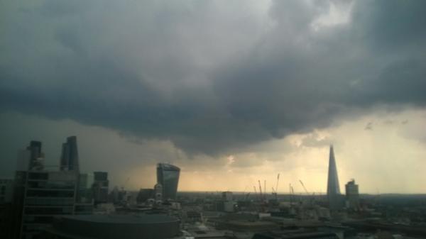
Monster, unforecasted I believe, thunderstorm approaching central London from Essex coast. R5 bullseye.
On 25 Jul 2014, Ian wrote:
OMG! London is black as soot at 1300hrs Friday 25th July. Sky is apocalyptic! Huge thunderstorm moving towards the Shard! Watch out for fireworks! Thanks for the warning Piers!
On 25 Jul 2014, Nigella wrote:
Still very hot in East Berks. Hit just over 30 degs yesterday & last night's low was a sticky 16 degs. Currently 24 degs & humid. Early morning cloud has mostly burnt off to a slightly hazy blue. Short term forecasts seem to be suggesting there may be some rain this evening. It would be most welcome as everything is looking very parched now. Grass has yellowed & I'm watering plants every day.
On 25 Jul 2014, Phil Ipswich Non Sub wrote:
There's another way of predicting some earthquakes... Fracking.
https://www.youtube.com/watch?v=gYZ8XH6Xn9c
On 25 Jul 2014, Rhys Jaggar (30 day annual subscriber) wrote:
Coming to the end of July , one can say that the month has been drier, hotter and sunnier than predicted in the forecast. We have a real drought here in NW London, with the ground in parts of the garden cracking and daily watering a necessity now for 3 week past.
We have missed most of the thunderstorms but heard the thunder and saw lightning, so I guess our rainfall was 5 miles away from being as predicted. I guess one can ask whether it is possible to make a forecast which says: 'most likely XXX but locally could be much lower rainfall if storms pass elsewhere'?
As far as the garden is concerned, July is like August for several things, notably tomatoes, peppers, cucumbers, dwarf beans. The quantity may not be higher in some cases but three to four weeks earlier than expected harvests. Every single tomato strain sown on March 5th will have harvested at least one ripe tomato by July 31st (there's one left and orange toms are already visible) - never achieved that before. 10oz bee
On 25 Jul 2014, Maria ( Ireland sub ) wrote:
Well we didn't get any thunder lightning over head but the distant sound of it all got close enough to hear it was all going on to the west of us, some lovely louder rumbles and crackling for about an hr after my last post, lovely out at midnight now starry sky and feels fresh! 16/17 deg....
On 24 Jul 2014, Craig M (@CraigM350, Berks, Sub) wrote:
Paddy - 28 is mighty impressive. Do you know the dewpoint/humidity per chance? I say this mainly as the S/SE is often subject to high humidity from the continent which makes a fair degree of difference between here and where you are - I know relatives that really struggled in the SE on visits (from Ireland) due to that rather than actual temps (back in 00's heat) and I refer back to the 10C winter temps I ofen use to compare which can be worlds apart but still the same max depending on topical or polar air being aloft. /Ever read 1984 and the doublethink bit? - perfect example is now. Rent seekers like Slingo tell us models are amazing - have they got s*** in their eyes? Seriously. I have heard of eye beauty in the eye of the beholder but when every sense tells you it's effluent then maybe you should trust your senses rather than a computer telling you that you are smelling roses.Hello?!?!?
On 24 Jul 2014, Paddy (Aberdeen south, 130m elevation, sub) wrote:
Phew what a scorcher! (apologies for that cliché of dubious origin) I know many of you don't like the heat but for us here - and we are heat worshippers anyway due to our northern location and rarity of real heat - but today the thermometer hit 28˚C, not quite the 30˚ we had last year, but good enough for us. This wasn't uniform all over the farm of course, we had a SE'ly sea breeze, welcome for once, to keep it fresher in certain places; on such occasions it can be a boon to be near the coast. 16˚ at 7.30 and now at 10pm still 17˚. == So far this pair of R5s is turning out rather better for us than expected, I will have to explain the whys & wherefores of this to our neighbour and contractor with whom I share the forecast; they managed to make some hay on one of our fields rather than the expected silage, with which they are overflowing this year. MO says heavy rain on Saturday night.
On 24 Jul 2014, Craig M (@CraigM350, Berks, Sub) wrote:
Paddy - a post on Haar for you. Bears out your obs well. === http://weatheraction.wordpress.com/2014/07/24/haar/ === Does anyone fancy doing a guest post? It could be how you use WA forecasts or just on how you've seen theweather changing in your area...or memories of an extreme event. I recently found out the date of my first weather memory in '78 and it happened to be a record (post soon) so any memories of such events I'd love to hear that if you have something similar. One of the biggest issues we face from warmist propaganda is amnesia so let's share what has been and will be again. Leave a comment at the blog weatheraction.wordpress.com or here and I'll share and do some digging for charts/newspaper reports
On 24 Jul 2014, Craig M (@CraigM350, Berks, Sub) wrote:
Oven turned down a notch today. The lovely refreshing breeze died in the early hours (so stuck to sheets again) but notably today was much cooler in the shade, it offered a degree of respite, direct sun oppressive. MetO going for 21 by Mon was 24 yesterday. Still due to be warm but far closer to average. Rain at weekend. / Gerry - UHI in Vegas (man made oasis in desert) reported as ~+10C for nightly minimum. What the dolts have highlighted is actual man made warming - models predict an Increase i
n night time temps which is like saying the sun will rise in the morning. We are measuring our impact on the local environment from more concrete and asphalt not carbon Iimpact - our impact is dubious at best. They then use these uhi sites to 'homogenize' places like where Paddy os tp be more like where WeatherAction's office is in the heart of London! Might as well measure the winter low next to your log fire & claim the sky is falling.
On 24 Jul 2014, Craig M (@CraigM350, Berks, Sub) wrote:
Michael from Japan if you are reading would love to hear your updates / obs on the reported heat wave === http://weatheraction.wordpress.com/2014/07/24/three-dead-as-heatwave-strikes-japan/ === I'm used to reading about high temps there so is this anything unusual at all? Also if you can do you have access to older records? If not official then people's recollections such as hot (or cold) periods? Many thanks Craig
On 24 Jul 2014, richard [subs east mids] wrote:
"The Met Office has defended the accuracy of its forecasts and said it gets it right most of the time.
Helen Chivers, speaking on BBC Radio Devon, said: Because technology allows us to look forward in time, and forecast in finer detail, we want more. We never say we are going to be 100 per cent right. We are right six days out of seven.
We have 85 per cent accuracy on temperatures for two days in advance. Its verified, and people can see those accuracy figures on our website.
The science and the forecasting is what we are really good at, and we are world renowned for it. We are assessed and are always in the top two weather forecasters in the world. The other one is Japan.
http://www.plymouthherald.co.uk/storm-Plymouth-basks-weekend-sunshine-despite/story-21663635-detail/story.html#tacok7GCK9qTDeYJ.99 i'm guessing they hope no one actually checks those figures and compares their forecasts with reality? 85%? Really?
On 24 Jul 2014, richard [subs east mids] wrote:
Hows this for a long range forecast by Meto [remember they lecture that anything over 5 days is 'impossible' . Not only does it predict the weather but crop production,population density, water scarcity and melting glaciers as well as the directions of trade and the importation of crops. Come on WA your slacking if you only stick to weather. Meto can tell us what the stock market will be in 10 years [but not what the weather will be next month] lol http://blueandgreentomorrow.com/2014/07/21/met-office-maps-impacts-of-climate-change/
On 24 Jul 2014, Maria ( Ireland sub ) wrote:
Sat 24 showing a good amount of strikes in Ireland @ the mo, can hear some distant thunder here between 5 and now @ 6.30 pm, other counties getting lots of thunder heavy rain and some hail....been 24 deg humid with lots of sunshine earlier and cloud now, trying to rain big drops but nothing here as yet, hoping it kicks off here but think the worst may miss us again in it's north west movement :-/
On 24 Jul 2014, Gill1066 East Sussex (sub) wrote:
Gerry - ate my first blackberry two weeks ago. Today - hay arrived in the barn. Bliss! Very hot again - though northerly cool breeze first thing. Off to do same evening routine - watering plants. Polytunnel very hot but both East / West doors open constantly as are both north/south sides. Produce coming along a treat. MO have showers forecast here for Sunday & Monday.
On 24 Jul 2014, Maria ( Ireland sub ) wrote:
Irish weather online reporting thunderstorms heading up the spine of the country moving in a North west direction, travelling back from Portlaoise at mo looking very hazy and so humid hope they get us too!-)
On 24 Jul 2014, Maria 45day sub somerset wrote:
very strange, my bare skin and the back of my neck have gone tingly, all of a sudden at 16.40
On 24 Jul 2014, Maria 45day sub somerset wrote:
32 and it is past 4pm. This heat is killing. I need to get to the allotment but no go until 8 I think. I am quite accepting that R5 is global and we have to think global really, got to be grateful to not get terrible extremes. I have cut down 4 large perennials in a raised bed today at 6 am, watering was getting beyond a joke. Sedums ordered instead. See, got to go with the flow
On 24 Jul 2014, richard [subs east mids] wrote:
lightning is lighting up europe like disnyland [@15.50] http://www.sat24.com/?culture=en
On 24 Jul 2014, Gerry N Downs 600ft 45d wrote:
Strong breeze yesterday evening and night, and still there this morning. More of the same hot and humid weather in London and on The Downs. Regarding plantlife, I have eaten my first blackberry already and there are others coming along. V early, especially as The Downs is usually a bit behind lower lying parts due to being colder. Lots of green fruit formed so a bumper crop coming. The Norwegian spruce has a large cluster of cones and the leylandii have copious mini-cones on them. Does it run that large amounts of fruit and seeds heralds a cold winter? Or just an indicator of the spring that has past? Note that there is some CME activity on the far side of the sun which I have learnt from Piers is connected to us despite no uptick in solar wind. Anyone watch the Clouds prog on BBC? Amongst some puerile dross such as cities being warmer even in the desert (Phoenix) really? UHI anyone? was the increase in humidity within the city due to gardens and hence rainfall.
On 24 Jul 2014, Bob Weber, N Mich USA subscriber wrote:
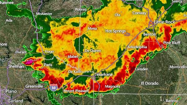
Piers nailed it again! Big drop in temps starting in northern midwest states over past day and a half has spead out southward. Most areas in US now colder than a few days ago. The moon that had delivered a nice warm blast a few days ago on it's last northward peak is quickly pulling the fronts southward with colder air behind. There was a long line of thunderstorm-lightning activity in the US last night that stretched from Texas to Maine, now out in the Atlantic. From http://iceagenow.info/2014/07/doomsday-hail-decimates-potatoes/ , 6 inch hail wasted Russian town for 5 minutes late July 22. Can't wait to see what else happens in the next few days... Clear and cool here this morning at 54F.
On 24 Jul 2014, steve (sub) wrote:
Just wondering, with what Piers says above re UK being slower to react to top reds than Europe and other continents like the USA. I read somewhere that the earths magnetic field is distorted mainly on "our" side of the Atlantic and especially near here. Could that affect how it responds to solar electromagnetic influence and therefore how our weather responds.
On 24 Jul 2014, Richard Pinder wrote:
Not on the so called impartial BBC due to censorship of climate science, scientists and scientific debate even with politicians and journalists. But on Al Jazeera, Freeview channel 83, 8pm tomorrow, Friday 25th July, Head to Head, presenter Mehdi Hasan challenges leading man-made global warming sceptic and world leading Atmospheric Physicist , Professor Richard Lindzen, at the Oxford Union, on his view that concern about global warming is alarmist nonsense. But alarmism is essential for generating funds and taxpayer money for the left-wing environmental social parasites at the BBC, Green party, Greenpeace, Friends of the Earth, Grantham Institute and Tyndall centre, because they want the worlds governments to stop the climate from changing. But Lindzen thinks that this is not scientifically possible, and therefore they are all a waste of space, which is why these social parasites insist that the BBC maintains total censorship.
On 24 Jul 2014, Nigella wrote:
Still baking here in East Berks. We hit 30 degs yesterday and only down to 15.5 degs last night and it is 27 degs at the moment with sunshine & light clouds. So fed up of being in the office!
On 24 Jul 2014, Wendy wrote:
sub. High Peak.Very hot yesterday 26, drove into Cheshire,even hotter ,car registered 30 at one stage!! Garden needs so much watering today!
Temperature has been consistently high for days here.Glorious weather,but difficult for sleeping.All windows and doors open.A slight breeze today which is lovely. Richard ,didn't notice any earthquake in this area,which isn't that far from Nottingham.
On 24 Jul 2014, Sasia Steinhorst (Neth. sub.) wrote:
@richard - Maybe the earthquake was a result of the 5,5 registered off the coast of Chili late at night on the 23rd? - OT: still hot although more cloudy than the previous days. Rain and thunder all around us but our little region is just not "getting any" ;-) Strange contrast in the garden: some plants are doing extremely well, others are withering away despite being watered. Honey suckle is pretty much doomed, all newly formed leafs are quickly turning yellow and falling off. The grape vine is shooting upwards, the fleece vine is going crazy and the bramble bushes are top heavy and producing edible fruit already. The tiny firethorn I planted 3 months ago has bloomed and is producing berries already. In short, Piers' warning that we're in for a roller coaster ride with regard to both weather and environmental changes has been - again - right on the money!!
On 24 Jul 2014, richard [subs east mids] wrote:
pretty sure we had a small earthquake last night-it woke me up. Channel islands and SE felt one http://www.bbc.co.uk/news/world-europe-jersey-28452733 plenty of sun and heat but also strong winds. Satellite has lightning coming into Devon Dorset while the Atlantic low is being funneled north by the jet
On 24 Jul 2014, Maria ( Ireland sub ) wrote:
Light breeze tailed off and another humid mild night though not as humid as previous night, yesterday was the hottest day in Ireland so far this year @ 25.3 deg.
18 deg @ 8.35 this morning sunny with variable cloud,
"Met are giving mostly dry with sunny spells but cloudier over some parts of Leinster and Munster with the threat of heavy showers thunder and possibly hail, temps very warm 22-27 wind light variable to easterly"
On 24 Jul 2014, Piers_Corbyn twitter (Gaffer) wrote:
THE CURRENT R5 PERIOD(s) A few comments came in which compared short range MetO forecasts with our Long Range forecast and thereby gave away forecast information so we did not release [eg Michael Lewis, which we have attempted later to release, now we are talking publicly about the detail, but for some internal computer reason it is not now/yet showing. Nevertheless MICHAEL your question about where is the rain is now answered above and in MetO maps which have changed towards our LongRange Forecast]. The main text above from me answers those queries now. Note as always Email witheld comms will normally be witheld by us unless we recognise who they are anyway and the usual anti-troll crieria are satisfied. Some enquiries are also taken as direct non public - ie private - enquiries particularly if they give away forecast information which we have not made public. Comments which ask where are things we have not forecast are normally ignored. The Rules are explained in pdf link above.
On 24 Jul 2014, CraigM (@CraigM350, Berks, sub) wrote:
Horizon dodged this image of ocean temp anomalies 98-2012 ---
DoubleThink The wonder of Climate Models===
http://weatheraction.wordpress.com/2014/07/23/doublethink-the-wonder-of-climate-models/
===
2) Polar bears and melting ice: three facts that shouldnt surprise you ===
http://weatheraction.wordpress.com/2014/07/23/polar-bears-and-melting-ice-three-facts-that-shouldnt-surprise-you/=== 3) Severe Flooding Continues to Devastate Russias Far East ===
http://weatheraction.wordpress.com/2014/07/23/severe-flooding-continues-to-devastate-russias-far-east/
=== / Fed up with humidity today. Very warm day.But slight fresh touch to air when wind picked up a bit. Tall white clouds. A few drops of rain when it clouded over early on.Clear now. Nice cool breeze since sunset which hasn't died down as on other nights. Trees rustling away is so much nicer than silence in muggy still air.
On 24 Jul 2014, CraigM (@CraigM350, Berks, sub) wrote:
Finally saw the full beeb Horizon free advert for speculative rent seekers. I have never seen such a polished skillful dodge outside of party political broadcasts. Atlantic in warm/pacific in cold phases? Dodged. Storms at same peak of solar max? Dodged. Climate modellers having a kick about missing the goal by more than a five bar gate & claiming a goal anyway? Dodged. Magnetic field weakening? Dodged. Arctic melted many times before? Dodged. Record Antarctic sea ice? Dodged. Similar rainfall in 1929/30? Dodged. Meridional 'buckled' jetstream & affect on weather known in the 60s & 70s (as per the late HH Lamb who researched the Litle Ice Age with many others noting circulation pattern change)? Dodged. Similar polar vortex affecting both UK and US in 1976/7? Dodged. Weeks of storms that preceded the great storm of 1703 (before rain guages)? Dodged. No warming for 18 years? Fiddled data?..etc...
On 23 Jul 2014, Paddy (Aberdeen south, 130m elevation, sub) wrote:
Today didn't turn out the scorcher the MO had predicted and that I had hoped for, the haar stayed for much longer and was always lurking near us, so it was cooler, even cold in the SE wind when I was in shorts & t-shirt, rather optimistically. 14˚C at 7.30, rising to a max of 21˚, back to 14˚ again by 10 pm.
On 23 Jul 2014, Steve (sub) wrote:
This part of Scotland near Loch Leven and between the Tay and Forth estuaries seems to miss the worst of weather most of the time. We often see it pass by in the distance. Certainly true this year. We have enjoyed gentle winds with only 2 exceptions in the spring and only moderate rain now and again - all that from the time of those terrible winter storms and floods in the south right up to now and in previous thunder periods we have had just a (dissapointing) few very short storms. Winter temperatures stayed almost totally above zero, often by a good bit and the last two months have seen almost desert conditions with dominant highs, easterlies and warm to hot (currently hot to blimey!). This is the palce for anyone who wants a quiet life - weather-wise at least!
On 23 Jul 2014, Maria ( Ireland sub ) wrote:
light east to south east breeze developing this aft. bliss...24 deg.
On 23 Jul 2014, Maria ( Ireland sub ) wrote:
Still some huge clouds around but more sunshine today and 23 deg. kids in pool :-) time to pull up a chair and stop trying to work in this humidity which was 100% in some parts last night...
On 23 Jul 2014, Maria 45day sub somerset wrote:
massive clouds recently moved in, 2pm. I feel like doing a rain dance, anyway all fingers and toes crossed that, as usual, meto needs to be intensified during R5. I bet the meto forecast (oops I mean instant weather cast) changes very quietly and sneakily. Oh I see they have quietly added some yellow to tomorrow
On 23 Jul 2014, richard [subs east mids] wrote:
Jet stream big meander swing off Ireland coast keeping the low out in the Atlantic.
On 23 Jul 2014, John Planet wrote:
The little ice age did have a lot of up and down years. The extreme cold and frost fairs did not occur every year. There were some winters very mild and wet as well. There were periods when both the summers and winters were cold. Other periods when the summer and wintes were warm, There were also periods when summers were hot and winters were cold. There were extremely dry periods and periods of wet.
On 23 Jul 2014, Nigella wrote:
Warm again here in East Berks. Hit 29 degs again yesterday & lowest temp last night was 15 degs. 22.5 at 10.30am today with a breeze & some light, hazy cloud blowing in from the East. I wonder if this will be another Westerly moving weather system that throws a spanner in the works?
On 23 Jul 2014, Maria ( Ireland sub ) wrote:
Cleo the Climate Kitty haha that's brill ! wish it would thunder here such a stuffy night could only sleep around 5 hrs, grey dull and 18 deg here @ 9 a.m humidity higher no doubt again.. Looks like the threat of thunderstorms returning in from the West to affect Western areas and possibly central later in the week...
On 23 Jul 2014, east side wrote:
I can confirm CORBYN is spot on here.
In European Russia there are wild swings just in the zone between hot Moscow with alternate cold/warm St Petersburg alone in the last month, while we suffer the coldest/wettest summer for years in Ural.
It's the worst cold wet summer in a decade,- yet the weather service in UK/BBC are totally unaware of it.
"There will be very HOT times in summers as well as more common very wet summers & some mild windy winters as well as EXTREMELY COLD winters. This for Britain & Ireland.
The same applies to USA but generally NOT at the same time. Overall world & each hemisphere COLD. Areas of cold in eg NH at any time larger than areas of heat - look now USA Cold N/E much larger than this BI and West Europe heat. Not to mention other parts of world.
Also extreme cold in Australia ignored by BBC.
transition boundaries between weather types in very contrasty situations difficult to pin down. You will have interesting weather in next few days."
On 23 Jul 2014, Bob Weber, N Mich USA subscriber wrote:
Heavy thunderstorms right now, with NO sign of this activity on weather maps I copied ten minutes ago! Cleo the climate kitty ran upstairs to hide from the storm. She knows it's an R5! Uncanny how US weather map features are lining up with Piers' forecast for today! It was very warm across the US today, all the way up into Michigan. I attribute that to warm air transported north from the tropics aided by lunar atmospheric tidal action, and as Piers' says, "magnetic linkages" wrt the now "superMoon". At 8pm EDT now we are less than 24 hours away from the lunar northern declination maximum, it's practically there now, within a few arc-seconds, between 18-19 degrees north of the equator. New moon July 26. It is going to be interesting through the end of the month. Bt was 6nT a few days ago, now 3.9nT. Solar wind around 330km/s, density under 1.0. Earth is now conjucting Jupiter and the Sun, see http://www.solarsystemscope.com/ , and will be more/less aligned until about the 26th.
On 22 Jul 2014, @Piers_Corbyn twitter, Gaffer wrote:
MARIA important point implied. YES It is an example of part of Mini-Ice-Age (AN OVERALL CONCEPT) or Wild-Jet-Stream-Age weather. Remember what we have said many times This WJS Age means wild swings and VERY LONG N-S fetches in jet stream and marked EXTREMES and contrasts. There will be very HOT times in summers as well as more common very wet summers and some mild windy winters as well as EXTREMELY COLD winters. This for Britain and Ireland. The same applies to USA but generally NOT at the same time. Overall world and each hemisphere COLD. Areas of cold in eg NH at any time larger than areas of heat - look now USA Cold N/E much larger than this BI and West Europe heat. Not to mention other parts of world. Also extreme cold in Australia ignored by BBC ALjazeera #Co2Con #WarmistFraud Lie machines. Our BI-Eu summer view working well but transition boundaries between weather types in very contrasty situations difficult to pin down. You will have interesting weather in next few days.
On 22 Jul 2014, Maria 45day sub somerset wrote:
I am very glad to be retired, so can pace myself all day. I agree re lack of oxygen and feeling airless. I get up early and am on the allotment by 6 am, by 9 am I am indoors, all s facing windows tight shut and solar shading verandahs doing their job. I am not liking this weather at all, give me colder moving air any day. Upside is the bumper wheat crops expected locally, I can hear the combine being prepared. It is past 9pm and is still over 24 degrees outside. Am making more plans for downsizing more pots and plants, I cannot cope with the watering, our 1000 litre water butts will not last more than a couple of days to empty. If this is fairly typical mia weather then adapting is quite a problem
On 22 Jul 2014, Maria ( Ireland sub ) wrote:
We did get a little sunshine in the end this afternoon and still high humidity so really muggy but actual temps cooler than other days this summer @ around 20 deg. sky broke up for a while then big clouds drifting back in early eve. On Irish weather online some counties had a fab hot day whilst others complaining dull grey muggy what heat wave, so yeah varies location to location...
On 22 Jul 2014, Gill1066 East Sussex (sub) wrote:
Just a comment re the 'Heathrow it rained - it didn't rain" argument. Sunday eve, my husband said to me that I wouldn't believe the fact that whilst at our home farm we were dry all day apart from a few sprinkles, 1.5 miles away on another grazing location it absolutely tipped down on him while he was in the field with the cattle. Just goes to show as I have said before, weather can be as different locally as it can regionally. No-one can forecast the weather for every square mile of this country at a given time; if they (Piers) could they would be a billionaire!
|


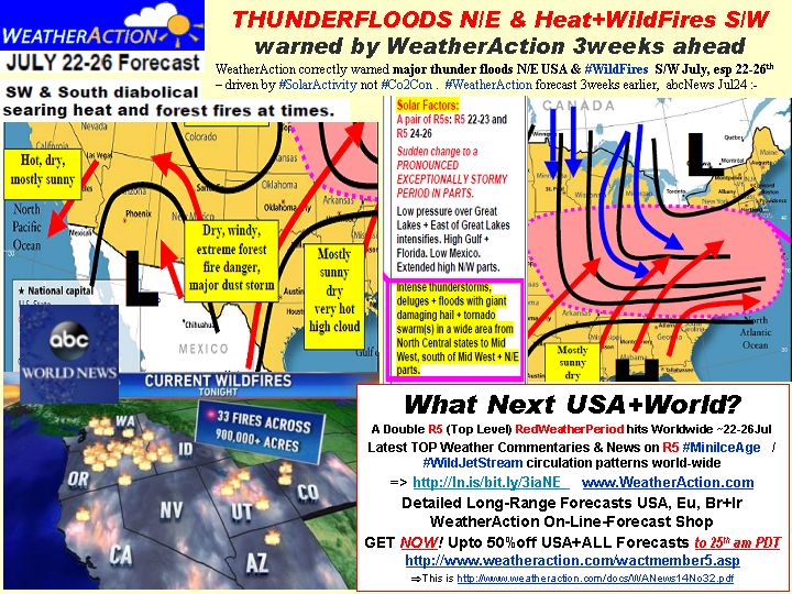


 In solar and Geophysical terms. There is not a very large amount obvious on the sun. However note R periods eg R5, R4 are not just about Sun but also about Sun-SolarWind-Earth magnetic connectivity. Solar-Geophysical aspects of this R5 so far