News from WeatherAction
Get the latest weather news here

www.weatherAction.com, +442079399946, +447958713320 , @Piers_Corbyn, https://www.facebook.com/piers.corbyn
WELCOME to WeatherAction!
WELCOME to WeatherAction!
- WeatherActionNewsRoom - For Feature News-articles and Extra reports for this blog: http://weatheraction.wordpress.com/
WeatherAction are World leaders in LongRange Forecasting
WeatherAction Forecasts are entirely different from all Standard Meteorology Efforts. They are for LongRange decisions in Britain+Ireland, Europe and USA - and other parts of the world and oceans at times.
They are not 'early' substitutes for short range forecasts but are for longer range planning and market purposes to ~+/-1day.
We may make specific medium and short range comments such as error warnings which will come in short range TV foreasts during periods of certain solar factors but generally direct you elsewhere for short range detail forecasts.
For Full information, independent reports of WeatherAction's significant skill and archives* of past foreacsts for more than the last 12 mths as well as Informative Links to other sites Go To (NB This & some other links may require copy/paste or Highlight/GoTo). Short Link http://bit.ly/RgEuYb = http://www.weatheraction.com/docs/WhatAreWeatherActionForecastsAndInformativeLinks.pdf
Archives carry all WeatherAction Web forecasts from Dec 2012 (& some before) to ~last month loaded for your reference http://www.weatheraction.com/pages/pv.asp?p=wact4 Special Asessment Reports also included.
THIS COMMENTS BLOGPOST- Contents:
1 PICS showing developments (newest on top)
2 Top Forecast Info on Forecast Services and important notices
3 Piers Current Weather & News-Commentary including solar +Geomagnetic; newest first
- Top Comment and Major Report/News - often for current Weather periods'
- Independent ongoing monitor observations and reports of weather periods in User Comms / main blog.
4 Some material from prior blogpost and Links + Special links to 'NewsRoom' site - IF NEEDED
5 Standard info and Links inc General Forecast info & User-Reader Comms (Troll free) Rules
6 User-Reader COMMS. YOU join in Comment & Ask Questions!
5 Standard info and Links inc General Forecast info & User-Reader Comms (Troll free) Rules
6 User-Reader COMMS. YOU join in Comment & Ask Questions!
THIS BlogPost started 2014 JULY 22nd on start of important WeatherAction Double 'R5' period 22-26 July
(Two consecutive WeatherAction 'Top Red' Solar-Weather effect periods: ~22-23rd & ~24-26th)
Piers' Latest Current Weather Commentary is further below
Important comms from Readers/Observers at foot of blog pages - including on what does MIA/Wild Jet Stream really mean in practice?
1. PIC REPORTS
July 26th Loads more thunderstorms USA (see twitter feed)
·
Thunderstorm passing over one of our static weathercams just now. Watch live stream here See time lapse> http://www.http://www.fifeweather.co.uk/index.php/weathercam

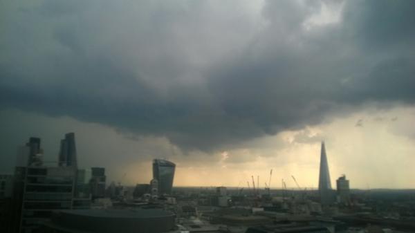
July 25th afternoon London Thunder hit in MO Yellow warning of 2 1/2 hr ahead.
CONFIRMING WeatherAction advice that MO-TV would underestimate intensities / events in this R5 period. Pic below. A rail facility in Surbiton was struck by lightning causing very extensive delays on trains from Waterloo. See @Piers_Corbyn twitter feed and Reader Comms below.
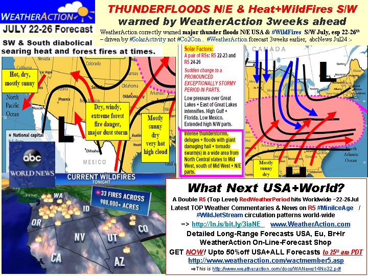
July 25 R5 period 22-26th Major thunderfloods + cool N/E USA AND terrible N heat and Wild-Fires S/W as forcast by WeatherAction confirmed (see more in News below)
http://www.weatheraction.com/docs/WANews14No32.pdf
July 24th morning Thunderstorm hitting SW UK in new R5 period, Latest Review below

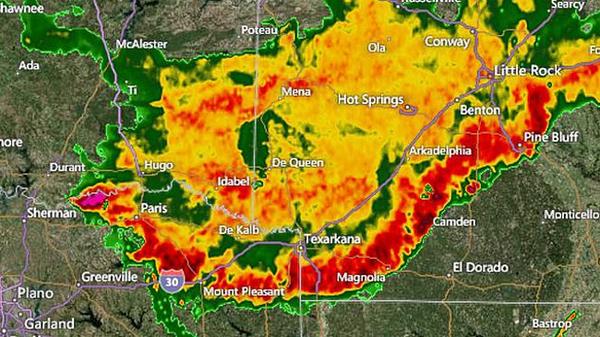
July 23/24 Massive Thunderstorms trashing Arkansas and many South Central USA states - See below
Pic below Portsmouth Lightning 17/18th July - NOT 19th - See Piers Comms (WeatherAction News Release) below on
Huge waste and disruption from Needless cancellation of 20 Heathrow flights on 19th July caused by BBC-MetOffice thunder-deluges 'Over- forecasts'

Subscribe now to WeatherAction 30d forecasts for
AUGUST and JULY IS FREE NOW
August loads 31 July
Br+Ir 45d detailed AUGUST foreacst with graphs is available Nowand what an August!
6m / 12m subs are charged for 5/9month
Prices & Subscription on-line shop => http://bit.ly/1bAYTtMNote To 24/25th OFFER NOW OVER............
=> "TheLOT" - 'All-In-One'/EVERYTHING
- FOR 12months - Direct NEW or Upgrade - is Most amazing value Forecast Service
=> Upgrades from existing subs to any service are available - pay difference via donations button and send message via 'ContactUs' (or we work it out if it is obvious)
WeatherAction Upload newsUpgrade charge = Rate per month X number of months
WeatherAction LongRange forecasts are the proven best.
=> SUBSCRIBE NOW
=> http://bit.ly/1bAYTtM
For full details of Services, prices and payment process
3. Piers' Current Weather Commentaries, News Reports + Links (newest on top)
JULY 26th AURORA SURPRISE: Auroras were *not* in the forecast this weekend. Nevertheless, "they're baaaaaaack," reports Bob Conzemius, who saw the Northern Lights on July 26th over Grand Rapids, Minnesota see http://spaceweather.com/
July 23/24/25 Latest R5 News - public, please pass on
On 24 Jul 2014, Bob Weber, N Mich USA subscriber wrote: {Reader Comm below}
"Piers nailed it again! Big drop in temps starting in northern midwest states over past day and a half has spead out southward. Most areas in US now colder than a few days ago. The moon that had delivered a nice warm blast a few days ago on it's last northward peak is quickly pulling the fronts southward with colder air behind.
There was a long line of thunderstorm-lightning activity in the US last night that stretched from Texas to Maine, now out in the Atlantic. From http://iceagenow.info/2014/07/doomsday-hail-decimates-potatoes/ , 6 inch hail wasted Russian town for 5 minutes late July 22. Can't wait to see what else happens in the next few days......"
http://www.weatheraction.com/docs/WANews14No32.pdf (as pic above)
The first R5 (~22-23rd) of this double R5 period has been well confirmed both sides of the Atlantic - at least in USA and Central and S/E Europe while effects have been partly blocked in Britain & Ireland. The second R5 (~24-26th) looks set to hit hard in all parts predicted especially later / in slight extension of the period.
There has been the usual, solar geophysical, earthquake, cyclogenesis & Tropical storm extra development in this period (see below)
USA Severe thunderstorms, floods and large hail in North/East & SouthCentral USA - in areas forecast by WeatherAction - and including the sweep south of much colder than normal air; giving extensive power outages, floods, wind damage, giant hail and airport disruption - see twitter feed and eg:- http://www.accuweather.com/en/weather-news/live-blast-severe/30837609
Europe Extensive major thunderstorms especially South & SE Europe in regions warned by WeatherAction - see (early hours of 24th): http://www.sat24.com/?ir=true&ra=true®ion=eu
Britain & Ireland For 23rd - when we had originally expected rains and thunder to get underway - there has been some noted increase in cloud beyond expectations of TV Met forecasts (see eg Reader Comms) in parts but rather like 15-17th (R4) the main active lows have been (initially) blocked in the Atlantic and heating maintained in S/E in the early part of the (22-26) forecast period.
The held back Low attack is INCREASING HEAT in Br+Ir especially central & East England for a couple of days delaying the rain+thunder action in the forecast before a very violent thundery breakdown - see 'WHAT NEXT?' Below
Tropical Storm extra development
=> TD2 (Atlantic) formed and developed in this period http://weather.unisys.com/hurricane/atlantic/2014/TWO/track.dat
=> Typhoon Matmo (W Pacific) ramped up from T1 to T2 in the period on 22nd http://weather.unisys.com/hurricane/w_pacific/2014/MATMO/track.dat just before hitting Taiwan when it weakened http://weather.unisys.com/hurricane/w_pacific/2014/MATMO/track.gif
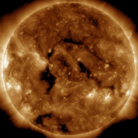 In solar and Geophysical terms. There is not a very large amount obvious on the sun. However note R periods eg R5, R4 are not just about Sun but also about Sun-SolarWind-Earth magnetic connectivity. Solar-Geophysical aspects of this R5 so far
(i) A Coronal hole is becoming Earth facing on 24th - see pic of 23rd from
http://spaceweather.com/archive.php?day=23&month=07&year=2014&view=view
(ii) There has been some uptick so far in Geomagnetic activity (same link)
(iii) An M6.9 (2nd M6.9 ie Largest= Quake this month so far) struck on 21st 94km NNE of Ndoi Island, Fiji 15.54GMT (within half a day of the 22-26th period) http://on.doi.gov/1niZPww
WHAT NEXT?
Standard Met shows rain coming into Britain and Ireland later in the period 22-26th
http://www.sat24.com/foreloop.aspx?type=1 which is now predicted to be wetter than had been expected before by standard Met. Due to the R5 the actual rain will be even more intense than this suggests and will be accompanied by major thunderstorms, large hail and likely some tornadoes.
The delay in effect may be interpreted as a Partial Cut Off High (PCOH) effect whereby the initial effect of the R5 is a High pressure block which then gets (largely) knocked aside (subject of investigation)
July 22 #MH17 and Top/Major Red R5/R4 periods and airline safety.
#MH17 maybe changed course on 17th July due to weather before coming down, killing 2NUFC fans - report in Newcastle Chronicle Live: http://ln.is/bit.ly/yzqQS
Piers Corbyn says "Given this was a 'Major Red' R4 (~15-17th+/-1d) period which had spawned some very intense thunderstorms (eg 17/18th night Br+Ire+Europe) a weather directed change of course seems quite possible although there is no suggestion any modified track was outside the internationally accepted air-lanes. Nevertheless a change of course may have confused any operators of missiles who may have been looking for a different plane into committing this atrocity on an aircraft other than one intended - unless of course 'any' aircraft was intended. What I am saying, I stress, is speculation following the point in the 'ChronicleLive' link and requires further investigation."
"In terms of upper air turbulence - and bumpy rides - this is exacerbated in R5 and R4 periods."
WeatherAction Forecasts General News
Up to 30d ahead forecasts for Britain+Ireland, USA, Europe and 'RTQ (Red weather periods & thunder/tornado+Quake risk) for May have been performing well.
As we go further into Mini-Ice-Age circulation the JUNE (WOW), JULY(WOW!!) and August (Really?!) forecasts are, as might be expected, very interesting and important both sides of the Atlantic.
What Subscribers say
Many idependent reports verify WeatherAction's world- leading significant forecasting skill (see Forecasts =>Accuracy on Home page) and from time to time we report individual user Comments. Hear Saskia Steinhorst a Nertherlands Subscriber on WeatherAction Euromaps Forecasts:-
"(re May)....It feels like the climate is like a ping pong ball, bouncing all over the place. Keeping track is hard and would've been virtually impossible if not for Piers' EXCELLENT forecasts! ..."
READERS COMMENTS & FEEDBACK RULES
THIS Site is DEFENDED SPACE - 100% Moderated and troll-free because of ongoing cyber flood attacks and to stop postings not of fair and honest intent and to engage in fruitful discussion..............
=> FOR RULES GO TO http://www.weatheraction.com/docs/USERCOMMENTRULES.pdf