Comments from Piers
WeatherAction
WELCOME to WeatherAction !

WeatherAction LongRange Forecasts are entirely different from all Standard Meteorology Efforts and are not 'early' substitutes for short range forecasts. 
For further and standard information see end of blog, blue section
Reader/User Comms are below blogPost text. Thank You

HOW THIS BLOGPOST WORKS - Contents Order: 
i.   Forecast Services latest info (Fuller details later in blogpost)
ii.  Timely News and special Comment
iii. Major Report - News - often for (current) Weather period.
iv. Some relevant material from prior blogpost
v.  Standard info on Forecast Services - General - User/Reader Comms Rules.
vi. User-Reader Comms (Troll free)


WeatherAction Forecast Services latest

Br+Ir Jan 2014 30d forecast is uploaded
Europe Regions Jan 2014 30d forecast is uploaded
USA Jan 2014 FULL Developments & Extremes is uploaded

Click here to read news articles in the bulletins:-
USA "Exceedingly Awesome Long Range Forecasts" say subscibers
Eu and Br+Ir:  Why so many storms, When will they end? 

Are You Ready For The rest of Winter?

WeatherAction Great New Year Offer 
*** ends  twelfth night 5/6 Jan *** 
Fulfill YOUR-WeatherAction New Year Resolution to Get Serious about Weather in 2014.
12 month Subscription Jan-Dec 2014 
OR* extend an existing sub by 12m
 for price of 8 months!
- ALL SERVICES! 
* You pay, we see it and extend sub. Text  +44(0)7958713320 for confirmation 
  • On goodwill voluntary condition (not enforceable) that you attempt to get someone else to subscribe and/or tell one of your weather sensitive service providers - Council, Railway, Energy Company... that they need WeatherAction forecasts, Thank you
Just Go  http://www.weatheraction.com/wactmember5.asp 

DETAILS of ALL WeatherAction Web-based Live forecasts are in Yellow Section towards blog end.

Also go there for UPGRADES 
30d=>45d Extends 30d to 45d(inc 30d) for only £10 per upgraded month
45d=>75d Extends eg JAN45d(which inc30d) to Feb75d (inc all 60d, 45d, 30d forecasts); 
only £30 per extended month via Donate button
Where there are ambiguities of what should be enabled the buyer is favoured

Why suffer in ignorance?
WeatherAction forecasts set the pace - miles ahead of all the rest of LongRange offerings in Newspapers, TV, and standard Met Computer models - Brit+Ire, Europe and USA
No-one else can give you anything as remotely reliable and useful as WeatherAction 


4 JAN 2014 Top Comm
3 Jan Br+Ir storm "Tremendous success" for WeatherAction 
  • Major Storm and Top winds ~R5+ 31Dec-2Jan(+/-1d) and R4 29-30Dec(+/-1d) warnings confirmed. 
  • Observed winds substantially in excess of MetO warnings
  • Worst storm for 20yrs in Wales and SW says Daily Mail 

Image preview
Stupendous Wave Barmouth Wales 3 Jan. Moral Don't sit beside the sea during a WeatherAction R5+ storm even if MetOffice didnt expect that much 

On 03 Jan 2014, shaun faulkner wrote in blog below
"Had to go back to net weather just to point out to those enquiring about your success. After suggesting using this recent storm prediction as a test of your performance... that despite all the naysayers. You were right again while MO didnt have this storm yesterday morning. 
WA comm: ie MetO 1day ahead forecast did not have storm of Jan3. 
Which net weather users were delighted to point out their models had no evidence of such a storm and considering how soon it was supposed to be they wrote ur predictions off as dramatic headlines. Even regular posters here saying ah well piers cant get it right all the time. 
Seems to me this storm today is in your give or take 2 day time frame of new year**. 
Serious lightning and hail here in south wales today. More heavy rain too with some powerful gusts of wind. Awesome Piers
**WA Note: THANKS SHAUN! The R5+ 31st-2nd+/-1d includes 3rd or as you say that gives 1Jan NYDay +/2d for a substantial storm which is what happened.

Piers says: "Thanks, Shaun, Craig, Matthew and all for monitorings and comms. As Craig's piece below showed the MetO expectation was top gusts 50-60mph ~1st (that might have been upped later of course as 'maybes' but we are talking main printed contentions here when MetO had something to say compared with what WA had said WEEKS before).  
Blog reports below and Twitter feed reports @Piers_Corbyn and some copied below show MetO winds were substantially topped as we warned they would be both in the R5+ (1st+/-2d in extended form BOTH on 1st Jan and 3rd Jan) and the R4 before 29-30th Dec +/-1d. 
"We've had tremendous feedback on this storm period, which is another triumph for WeatherAction. Not only were our wind warnings Br+Ir a stunning success but also all our solar + geophysical forecasts were confirmed in this R4-R5 pair top Red periods: - Extra active earth facing sunspots amd Coronal hole, aurora, and major quake-volcano events. The extreme local turbulance (quasi tornadic events) high gustiness, ferocious waves, large (on English measures) hail was also significant especially on 3rd which is very pleasing. 
Our 45d ahead prospect for more N'ly flow & snow ~1Jan  was, on 30th, withdrawn (for 1st) and postponed till later and not in 30d forecast where an extra column of comment and Auroa-solar news was inserted to explain why. 
A couple of blog comments which don't seem to be aware of this - which was blog posted as information here first -  and/or which give away or imply things about future forecast content have not been published.
"As we warned snow will come soon." 

Some twitter feeds / info Gust reports newest on top:

3Jan 20:00
Embedded image permalink


3Jan 1800
Embedded image permalink

3 Jan Ilfracombe N Devon what-a-wave! 
Embedded image permalink

3Jan Hail Bruton Somerset!
Embedded image permalink

1 Jan 1400 Gusts
Embedded image permalink

30Dec 0800
Embedded image permalink

3 JAN 2014 WeatherAction Special Warning & Top Comm
Publication of this material is welcome and unlimited, actual forecast content is not public except with Agreement of WeatherAction - Contacts +44(0)2079399946 / +44(0)7958713320 mobile
(Effects of) R5+ (31st-2Jan +/-1day) continue 
Snowmageddon USA and Rainmageddon UK & Eire continue:
  • Earth is still in fast solar wind blast from Coronal Hole (3 Jan Pic below ) which was Earth facing ~1Jan in middle of R5+
  • MORE FEROCIOUS EXTREME damaging wind and rain/snow storms now heading for Ir+Br & NW Europe and USA (Snowmageddon) 3rd and 4th Jan.  These events should be considered as part of R5+ (highest possible danger) 31Dec-Jan2(+/-1day) and are likley to be as intense and damaging as our Oct 28th Br+Ir+ Eu storm but note storm tracks not the same.
  • UK Govt holds weather emergency 'Cobra' meeting but do not invite WeatherAction - preferring to not know what will develop and the public to suffer rather than put the noses of Met Office - BBC - CO2 warmist sect out of joint. Meanwhile Piers Corbyn is getting more and more invitations to Radio interviews on the storms and what next.
    • Piers says: The situation is insane. Standard meteorology cannot cope with what is going on. The MetO have - as we warned - consistently underestimated storm dangers in our R5 and R4 periods and we can give a clear view on where this is all leading and for how long. Despite their 'concerns' about green energy surcharges (aka theft) the govt continue with the CO2 green lie. They have only shifted the green energy theft into taxation and in reality don't care about the ongoing public suffering in these storms. If they did they would involve WeatherAction NOW to get a better measure of reality and take legal action against electricity companies failures to re-connect electricity in good time, end the nasty behind the scenes subsidy arrangements they have with them on handouts to better-off housholds for self-serving green measures, and indeed end all green surgcharges AND TAXES now"
  • ANOTHER group of savage solar active region (AR1944...pic below Jan 3) now emerging which will become Earth-Facing ~Jan 10th (weather period 7-12th)  marking WeatherAction's next R5.  The Met Office - BBC havn't got a clue about the significance of this, do not want to know and do not want the public to know. WeatherAction subscribers to Br+Ir, Eu and USA forecasts ALREADY KNOW.
    • The new very large and deep Atlantic Low heading for Br+Ir in current standard models for ~7th or 8th or 9th is part of this serious time window 7-12th. In view of public speculation subscribers will get an update comment soon on this storm prior to WeatherAction further public comments.
  • One would have thought the crane blowing onto the Cabinet Office roof in Piers' Oct 28th storm (predicted 23 weeks ahead*)  which the MO underestimated in strength would be a 'wake-up call'. 
  

2 JAN 2014 HAPPY NEW YEAR and Best wishes to all!
Thank you for all support and feedback in 2013. We have made great advances last year and with your backing we will make more in 2014, Thank you! 

As can be seen from twitter @Piers_Corbyn and other reports; WeatherAction solar, auroral, stratospheric warming and weather event forecasts are going very well in this first weather period of the year 1-3Jan - which overlaps / extends last period of 2013 and includes the very important R5~31st to Jan 2. 
  • Note the X-ray and proton flux graphs below are auto-updating and show a major increase in Solar Flare activity - on the edge of X flare level from late on 31st and on 1 Jan
  • Further extra warming of parts of Upper stratosphere and wave pattern confirmed 1 Jan - in line with WeatherAction trial for main effect ~ 28Dec - 1Jan
  • Amazing twitter feed confirmations coming in of N/E USA  Snowmageddon WeatherAction warnings in our extension of last period 2013 to First period 2014 (1-3Jan) - see loaded USA forecast. R5+ ~31st Dec - 2nd Jan 
  • Top winds in Eire+Brit 1 Jan exceeded MetO as WA warned and higher winds still likely in R5+ / weather period 1-3rd Jan 

Antarctic Too much Ice Crisis News:

The Green Fools are fleeing! So when will the grip of the ice loosen? - See below 

Embedded image permalink

Piers says "The Ice will weaken as winds change in WeatherAction's next big circulation change which is around ~17JAN so maybe by 20th or so they could have another go at getting the ship(s) out. We base this estimate on the fact that the world weather system is just that - a world system. Major changes in the NH circulation and Jet stream have correspondences in the SH. [Follow reports from our New Zealand & Australian subscribers and you can see that]. Subscribers to WeatherAction Eu /Br+Ir or USA will have noticed major changes in circulation through 17-20th and I estimate it is 80% likely this also means DIFFERENT winds in Antarctica which should do the business. 

Of course when this happens the Warmist liars in BBC and the intellectually strained Independent, Guardian and New York Times will doubtless say the wind change is a sign of their lost Global Warming cause being redeemed. 

I urge all who support evidence-based science and accountable policies THIS YEAR to give these fraudsters, spongers and thieves NO QUARTER WHATSOEVER. We have to make 2014 so uncomforable for them and their lie machine that they would wish they could return to the sanctuary of an ice-bound ship or a Russian jail to escape the wrath of the people who are now suffering - and some dieing - under rising fuel charges and hiked food prices and taxes which are a direct consequence of the insane policies these green parasites have foisted upon the world".

PLEASE CIRCULATE THIS FORECAST AND COMMENT WITH ACKNOWLEDGEMENT. Thank you.


30 Dec 19:30hrs
New Years Day and thenabouts - Piers
Subscribers are wondering so this is to let you know that our first period in Jan 45d has been changed*** in some aspects in transfer to 30d and nothing else in Jan has changed. We are not in the business of short range forecasts but we can apply solar factors to MO short range models and/or - in this case - modify emphasis on aspects of our long range forecast in this particular time window (1-3 Jan). 

(added 2 Jan) ***THE change reduced Br+Ir Northerly flow and snow risk in 1-3rd - but NOT reducing snow risk to zero - and kept serious storm warning and all those upper atmosphere and solar event forecasts (ALL being confirmed). 
There is still snow to come in January and specifically as the general cooling we expected in the first few days of Jan Br+Ir (Full 30d forecast) takes hold some snow (other than Scottish mountain snow) is likely in later R%+ related storm waves in 1-3rd Weather period and MO maps are now suggesting this posibility.


29/30 Dec overnight 
Guest Current Weather Commentary from CraigM350
(see also User Comms entries below main BlogPost)
FEATURED

A Stormy New Year then Snow?

The purpose of this post is to show things as they stand ahead of a very active period of weather, which subscribers to Weather Action have know of since mid November. Piers Corbyn said

falls in our new R5+ period [top level warning] so we expect it will be more significant and potentially damaging [intense] compared with normal conditions than the storm of 23-24th Dec for example and we expect significant snow [Northerly flow] in it’s wake


Piers says: I recommend Craig's piece. There wil be further comms in the 30d Jan forecast on early Jan. Right now it is very pleasing that our warned (from 6 weeks ago) increase in solar activity has come on cue and extensive aurora are now deemed likely by short term solar observers  ~2-3 Jan so watch out for breaks in the Northern night sky.


29Dec 
"New Years Day 2014 MAJOR STORM" is coming
 
New solar eruptions on cue for MAJOR Top Red R4-R5+ 29 Dec- 2 Jan Solar & Weather Action period - Pics 28 Dec 
  • MetO shows new Low off SW Ire which will be of major importance says Piers - - contrary to Met O view that it will not be as important as recent storms
Solar Active Region AR1936 wakes-up as it moves nearer to ~Earth-Facing for R4 29-30th.
Coronal Hole set to become ~Earth-Facing for R531st-2nd Jan. See 'RTQ' Table below.
New X ray and proton flux bursts 29 Dec - shown on graphs for those dates. [CURRENT versions of these updating graphs below]
 so 
Image preview  
   

3-day GOES X-ray Plot

3-day GOES Proton Flux plot

Image preview

29 Dec 06:00am WeatherAction Imminent New Year's Day Storm Warning
Piers says "On 28th around 2pm The MetOffice showed, on BBC News 24, a new Low heading for SW Eire and said they didnt expect it to be as significant as recent Lows. However it falls in our new R5period so we expect it will be more significant and potentially damaging compared with normal conditions than the storm of 23-24th Dec for example and we expect significant snow in it's wake".

Important - The storms in UK+Ire+Eu and USA 23-24th wereSIMULTANEOUS with a major Radio storm on Jupiter. See 29Dec Space-Weather.com link above

28Dec 00z GMT 
Special Extra item from Piers Corbyn added at front end of this Storm blogPost

WHY ARE WE GETTING ALL THESE STORMS?
Prepare for even more dangerous storm events including 'smowmageddon conditions' in parts of Britain / Ireland and Europe!
"December has been unusually stormy, as predicted in our WeatherAction forecast, in Britain+Ireland, parts of Europe and USA (also as we predicted) and around the world. 
The reason is certain persistent solar influences and their lunar modulation - specifically a swarm of Top Red, R4 and R5, weather action periods which have covered a much higher propertion of the month (~2/3) than normal and the very active and wild Jet stream which is also related to the greater incidence of R4s and R5s and the Mini Ice Age circulation patterns now dominating the world.  
The R periods and wild behavior of the Jet Stream are driven from above and are associated with extra and extreme changes in electrical and magnetic activity above the stratosphere and in the ionosphere and the solar wind of charged particles coming from the sun and events on the sun itself**
[**Note Ideas such as 'temperature contrasts drive the Jet Stream' are totally inadequate to explain or predict events. Such a picture cannot explain the relationship between Earth weather and events in the ionosphere, magnetosphere, the solar wind and on the sun and the simultaneity of extreme storm events across earth and their ~coincidence with (radio) storms on other planets. Indeed such a low-level Earth atmospere centred view, notwithstanding certain feedbacks, is akin to suggesting the movement of tree braches causes winds.]

This extreme agitation of the atmosphere and increasing storminess is NOT going to go away but will increase again along with extra solar activity, and auroral displays particularly around the turn of the month and again in January.
Extreme and dangerous weather is predicted by WeatherAction's Solar Lunar equations particularly from around Dec 31st to Jan 2nd (an R5period) {as WeatherAction forecast 6 weeks ahead and is in 30/45d forecasts}.
This will include severe storm force damaging winds (Force 11) in Northern and Western parts - gusts of 90-100mph and more - with blizzard or 'snowmageddon conditions' in Scotland and North parts of England, Wales and Ireland likely, more flooding, and wind driven North Sea storm surge threats to English and Dutch North Sea coasts in the wake of the storm (enhanced by New moon 1st Jan).
Further information about January is in the 45d forecast.
Thank You"


26+27Dec+...
SIgnificant Storms developing on WeatherAction cue: 
Marking WeatherAction Red Weather R4 period ~26-27th; Br+Ir+Eu and USA 

The Storms ~27 Dec and follow-on: 1 Br+Ir+Eu,  2 N-NE USA

1. Brit+Ire+Europe (Newest top)

=> WeatherAction Warnings arising from R4 ~26-27th CONFIRMED

27th 12:00
Max wind speeds today 27th well in excess of Met ffice 70-80mph warnings and what happened on 23-24th  (Report:   ) See twitter feed - some extracts: 

At Aberdaron the wind has almost reached hurricane force 12 with a mean speed of 71mph! Gust 102mph 7am  

Top gusts from latest : 137 mph on top Cairngorm Summit. Grt Dun Fell, Cumbria saw a gust to 113 mph. 85 mph on the coast...

There are loads of impressive wind and flood pics on: 
http://www.dailymail.co.uk/news/article-2529433/More-Christmas-misery-ANOTHER-storm-set-batter-Britain-tonight-thousands-remain-without-power.html
Here's two
Wobbly windy landing at Leeds-Bradford airport
Image preview

Tree downed in Southwark, London, near Piers Corbyn's home
Image preview


27th 05:00 ALREADY WeatherAction warning of more severe winds than MetO / standard Meteorology would forecast has been confirmed - see reports from Users/readers below foot of blog of the storm in Eire and NW Wales - 109mph - much bigger than MetO '70-80mph' of only 12 hours ahead.   
Some Comms in previous blog also


Xmas day Report and Re-warning:
AMAZING! match between WeatherAction Forecast 6 weeks ahead for ~27th Dec and Met Office short range.
"This storm is in another of our Red Warning R4 periods. This will be big and dangerous - with STRONGER WINDS THAN METO WILL EXPECT FROM eg 26th. There is more to come after this one too", said Piers Corbyn astrophysicist WeatherAction, on 24/25 Dec.

WeatherAction detailed forecast issued on 14 Nov for the period 25-27th Dec said 

Likely possible weather map scenario: 
Deep Atlantic 'dartboard low' heads for Scotland probably passing over on ~27th.....

YOU NEED to subscribe to WeatherAction if you dont already! 


24th Comment Brit+Ire+Eu
Forecast users will have noticed that while our forecast for ~21-24th Dec (LOW confidence, 70%) correctly predicted very mild conditions Br+Ir and less mild later in N/W, the winds were underestimated. 
Nevertheless (and well done Rohan winter subscriber, Croydon - see Comms previous blog) forecast users applied the WeatherAction Rule that WHATEVER the forecast outcome detail in an R4 or R5 the standard Met forecast winds will need enahncing - That was confirmed.


2. N-N/E USA 
WeatherAction foreacst and developing snow storm ~26-27th... match well

Embedded image permalink

WeatherAction USA forecast for 25-27Dec (espec 26-27 for R4 action) issued 29 Nov


The Solar Drivers of the Red Weather hits All Dec
- A lot of R5+R4 periods this Dec  R4 26-27 drove this storm
WeatherAction 'RTQ' (Red Weather, Thunder/Tornadoes, EarthQuake Risk) 
(= 'Extreme Events Rest Of World') Forecast
 

27 Dec
Solar wind speed rose sharply 260-320 km/sec around 05:00 in WeatherAction R4 26-27Dec 


Recent Weather NewsMain Headlines: 

REPORT OF WEATHER 24 + 25 Dec 
WeatherAction forecasts for a quieter time than before and after and a 'green Xmas' - as forecast by WeatherAction in 45d detail released mid-Nov (and announced on BBC Radio York in recording of 12 Dec in Paul Hudson interview) were confirmed:-  http://metofficenews.wordpress.com/2013/12/26/was-it-a-white-christmas-2/


25th & 24th USA and South Canada  forecasts in run-up to Xmas and Xmas itself have been turned out excellently (see Comms from users).


"ABSOLUTELY OUTSTANDING" Forecasts for SE Canada (Montreal-Ottawa-Toronto) says Robert-Michel of Montreal re ~21-22 and snow hit 18-20 also forecast by WeatherAction and Worst Ice-storm ever says Toronto-Hydro. Report+pics for USA and South Canada 21-24th Dec section of December WeatherAction forecast issued 29Nov. See previous blog 

Sudden Stratospheric Warming 
25 Dec map further to 23 Dec previous blogpost 
Joe B Embedded image permalink

23 Dec Upper stratosphere warming starting in line with Piers' revolutionary trial prediction (in Br+Ir 45d prod 15Dec) [for peak ~ Dec28-Jan1st (uncertainties)]:
Piers said 23 Dec "This is fantastic news - our, the world's first ever, Polar Upper Stratwarm prediction is coming true - another breakthrough for WeatherAction".   


LIVE FORECASTS
From 22nd of any month Subs to 30d forecasts pay for next month (issue last day). Present month free

USA Maps Developments & extremes 30d, JAN 2014 
10 pages, is in: USA Maps 30d (extreme Events); and 'THE LOT' (All Web forecast) Services.

Br+Ir 30d JANUARY 2014 6 page inc graphs+Maps is 
in Br+Ir 30d, 45d & 75d and 'THE LOT' (All web forecasts) Services
Sub to this now gives free access to previous
IT'S ANOTHER MUST HAVE interesting Forecast from WeatherAction 

Br+Ir 45d (January now) SERVICE 23 pages
Br+Ir Detailed 45d forecast inc graphs+Maps  6 pages
with Euro Pressure maps (9pages) current + RTQ Forecast (2pages) Current 
and current 30d Br+Ir (6p)

Br+Ir 75d (February now) SERVICE 24 (=>26) pages
BR+Ir Essence of Feb 1 page - which will also be updated in more detail ~60d
PLUS ALL CONTENT OF 45d

Euro maps 30d service comprises 20 pages
Sub to this now gives free access to previous
- Euromap Regional forecasts - 9 pages
- Euro+ N Atlantic + Br+Ir Pressure map Scenario forecast - 9 pages {also in Br+Ir 45d & 75d}
- RTQ {Red ('R') active weather periods & Thunder/Tornado & Quake (Trial) risk} - 2 pages

Europe Extremes Only, 30d (edit of Region Maps) 9 pages
Sub to this now gives free access to previous

Europe Pressure Scenario maps 30d JAN 2014 9 pages loads into:
Euoromaps 30d; Br+Ir 45d, 75d; The Lot - All Web forecasts
Sub to this now gives free access to previous
Pressure Maps this month include extra annotations about certain optional possibilities for Eu and Britain+Ireland.
Euroservice comprises:
Anyone and new comers. 
Welcome and Do get in touch with any questions / comments / speaking requests. Via the blog below for espec public comments (Please indicate) or via:
piers@weatheraction.com 02079399946 / 07908734296. 

Get ahead of the rest with WeatherAction - 
- world leaders in long range weather forecasting.


LATEST WeatherActionTV and News VIDEOS 
The CO2 Warmist are on the Run - Time to finish the Job

DECISIVE:  Piers Corbyn dismembers the UN Climate Committee report meeting held at the Royal Society 2-3 Oct 2013 => Weather Action TV Report Sept/Oct 2013  - UN Climate Report - A Disgrace to Science  http://www.youtube.com/watch?v=JsAlxTL4QeM 
Short link = http://bit.ly/1fNK2mv 

 RELENTLESS
Nigel Farage leader of UKIP nails the Global warming Lie at the European Parliament  
http://www.youtube.com/watch?v=PwMOsocu5Rg 
Short link = http://bit.ly/Ip1sqZ 


++++++++++++++++  Standard Material below  ++++++++++++++

What are WeatherAction Long Range forecasts?
WeatherAction Long-Range forecasts are entirely different from all others.
They are produced using scientific advances in understanding predictable aspects of particle-magnetic effects from the sun which, along with lunar factors, change world weather systems in ways which have generally happened before. Through this approach WeatherAction can predict many key changes on the sun and associated changes in circulation, the Jet Stream and weather events with independently proven skill and unrivaled reliability (See Forecasts/ Accuracy button). Standard Meteorological approaches of forward projection of the present state of the atmosphere acting upon itself fail beyond a week or so ahead because they ignore external solar influences and so will never succeed.  

WeatherAction LongRange forecasts are not 'early' substitutes for short range forecasts.  
They are intended to help decision making well ahead of events for which advance planning, like booking harvest machinery or gaining advance knowledge of likely energy prices, is a NECESSITY - in situations for which short range forecasts would be too late.
For this reason WeatherAction does not normally give detailed Short Range updates because such are 'too late' for the use of subscribers; although for major events we do comment on how short range standard meteorology forecasts are likely to be in error on occasions. FOR MORE SEE AN EARLIER BLOG:

Past WeatherAction forecasts available in Forecast Archive 
http://www.weatheraction.com/pages/pv.asp?p=wact46 for ALL AREAS - Brit & Ireland, Europe, USA and 'RTQ' (Red Warnings, Thunder-Tornado & Sudden Polar Strato-warms in season, Quake risk) Aka World Extreme Events. Now updated to cover all seasons - including all forecasts produced Dec 2012 to NOVEMBER 2013 (and many prior to that). Go, See what we said before anyone else!

LINKS to important Weather & Climate & other sites 
IceAgeNow  http://iceagenow.info/ - Superb exposes of CO2 delusions!
WeatherOnLine:  ECMWF, GFS model movies &c (Don't take literally!) 
ClimateRealists (Twitter) https://twitter.com/ClimateRealists
1stHandWeather (USA+World) https://twitter.com/1stHandWeather
Wunderground Tropical Cyclones http://www.wunderground.com/hurricane/
TallBlokeWeather-SolarScienceBlog http://tallbloke.wordpress.com/
CraigM TopWeatherObs+Analyst http://craigm350.wordpress.com/
AccuWeather (USA+World) http://www.accuweather.com/en/weather-news
NationalHurricane Centre http://www.nhc.noaa.gov/gtwo_atl.shtml
Fixing Computers! http://www.brainboxcomputers.co.uk/
BigJoeBastardi https://twitter.com/BigJoeBastardi Top model watcher & AGW critic
https://www.facebook.com/pages/Torro-the-UKs-Tornado-and-Storm-Research-Organisation/249176491778442

LINKS Latest Solar-Geomagetic activity data -SpaceWeather.com: 
http://spaceweather.com/archive.php?day=05&month=09&year=2013&view=view choose day
USGS Earthquake Reports  http://earthquake.usgs.gov/earthquakes/search/ (Warning: overly complicated and 'clever' if you just want simple information, since it was 'improved'. Useful summary links have been discontinued)

Sunspot numbers and Solar Activity
Last 6 cycles up to now (19-24 inc) http://sidc.oma.be/sunspot-index-graphics/wolfmms.php
Plot since 1700 http://sidc.oma.be/sunspot-index-graphics/wolfaml.php
General SIDC (Solar Influences Data Analysis Center) Link 
http://sidc.oma.be/sunspot-index-graphics/sidc_graphics.php 


READERS COMMENTS & FEEDBACK RULES

THIS Site is DEFENDED SPACE - 100% Moderated and troll-free because of ongoing cyber flood attacks and to stop postings not of fair and honest intent and to engage in fruitful discussion.

THANK YOU for the many well informed comments on this site. 
All fair comments including critical points are published.

Exceptions to publication are: 
- pharmacy-obscene-spam, obscene terms, product and service promotion-spam and libel (Note WeatherAction publishing site as well as original libels are culpable since publication was allowed). 
- Items which reveal paid WeatherAction forecast detail, 
- Items which are in a large or central part false or rude (by accident or design) in which case writers may get a direct response, or be ignored. 
- Items involving swearing
- Items which are irrelevant and/or trollish in which case they may be advised, or not, on where to go. 
- Items from people who do not use real names and persistently do not provide an e-mail address may be ignored depending on the circumstances.

NOTE We normally REQUIRE proper contact information for anyone making or claiming to make Observational Reports specific or general. We have had a number of instances of questionable 'information' being offered from 'no contact' or people purporting to be subscribers who are not.  

THE KITCHEN TEST. This web site is not a public place for unconstructive exchange and false accusations but more like a personal kitchen. So if you sent in something that was ignored (note we publish almost everything) ask yourself if someone walked into your house and kitchen and said what you said or implied would you let them stay or send them out.

When commenting please say whether you are a subscriber or not and give your approx address / location (or precise location and Obs time if giving a weather report!).
When commenting on a WeatherAction (or any) forecast refer to actual forecast words as far as possible because some summaries / notes circulated, ‘reports’ of forecasts have been or can be misleading. Also include actual obs / web links where possible. Please give working links when you refer to other articles/sites.

THANK YOU 


Comments submitted - 62 Add your comment

On 08 Feb 2014, Les Parsons wrote:

Hi Piers As Dermot from Tasmania said it would be great to have a Australia New Zealand weather action forecast. I know farmers here would subscribe by the hundreds if you could help. Currently New South Wales and Queensland are in a terrible drought. The drought is effecting farmers around here I live with cattle being shot because no feed and no water.Some farmers are shooting their cattle and then themselves.I subscribe as a believer in you.
On 05 Jan 2014, Paddy (Aberdeen south, 130m elevation, sub)) wrote:

Frosty morning, temp -1˚C at 7.30, not a breath of wind under clear sky and sunshine until about 10.30 then cloud moving in gradually from the W, cold SW wind picking up, slight rain starting around 4pm. This got more intensive and by 7pm it was lashing and went on into the night, temp stayed at 5˚C most of the day, then rose to 6˚ by 10pm.
On 05 Jan 2014, Steve D (Sub) Waltham Abbey wrote:

http://news.sky.com/story/1190455/polar-vortex-to-plunge-us-temperatures-to-60c
On 05 Jan 2014, Mike wrote:

45 Day Subscriber. Hi Piers. As you have posted, that NOT ALL will see snow. As a subscriber, will we have a update of the month, be put in our subscriber box. I hope so, as this is what we pay for. Keep up the good work. Regards Mike
On 05 Jan 2014, Not supplied wrote:

Asim depending where cold comes from affects who gets snow. In 2012 the S/SE saw snow & freezing conditions whilst the rest not so. S does best from continental sourced air (often from Siberia) rather than more Northerly (Arctic).. Much depends on the source of the cold winds - even a NW can bring snow if the polar air is cold enough or if the precipitation is strong enough. But as to what is coming you have to SUBSCRIBE +++ Quite a few model members going for a pattern change around a week's time. Cold is in the mix and almost all models are going for a drop in temps (n.b. to avg/below av) only a small percentage go for something of note but the signal is growing slowly. The strat warmings are moderate but could well throw something in the mix as the core of the polar vortex gets put under pressure and not only moves but is stretched (think of a bath water going down plughole is a vortex-subject to waves when you jump in the water=change of shape+location)
On 05 Jan 2014, Asim wrote:

Hi piers if not all seeing snow does that mean south east? Like London area? I bet it does..
On 05 Jan 2014, Dermot (occ subscriber), Hobart Tasmania wrote:

5 days of strong winds with gusts of 100-165kmh at the 1300m peak behind Hobart. Still blowing strong with gusts of 60-90kmh. http://www.bom.gov.au/climate/dwo/IDCJDW7037.latest.shtml Loved the MetO explanation in today's Sunday Times - the Ebdon effect! That's what's causing this. Nothing else. Nope, must be the Ebdon effect or something other than that funny glowy thing in the sky spitting out heaps of radiation at us. Hmmm. What about asking what caused all of this rather than looking at the symptoms? Any chance of an AusNZ subscription service? Would be interesting way to disarm the Green's who have put this country in an economic mess. Reckon you would get some good media coverage. The new government are in your wavelength Piers. Would be a big breakthrough.
On 05 Jan 2014, Piers_Corbyn (twitter) WA Forecaster wrote:

THANKS ALL FOR GREAT COMMS and yes IMPROVED TYPING and READABILITY === CHRIS H, MARK MANCHESTER, Yes this seriously EXTREME weather is all part of Mini Ice Age Circulation with the added extra of our 'Swarm' of Top Red Weather periods etc. On the supercold Br+Ir or not, note: 1. We have got the StratoWarming we predicted which leads to MORE waves in Jet stream and MORE SNOW for some (but NOT ALL). 2 There is more information to all those who SUBSCRIBE and make what you see before you possible. Thank you and == WELCOME NEW RE-TWEETERS AND NEW TWITTER FOLLWERS who are becoming increasingly ILLUSTRIOUS I note!! === These are the most interesting weather times for at least 60 years and likely since the last MIA ~200 years ago.
On 05 Jan 2014, Russ 45day Derbyshire subs wrote:

Paddy... re: green ferns. I forgot to mention that we saw green healthy ferns under tree cover, mostly dense, mature silver birch, on new years day. Saw a news article yesterday about daffodils flowering in Scotland, so keep a look out......... Our doggy pooped with bum pointing due east tonight with a relatively calm solar wind...but we'll keep monitoring him.
On 05 Jan 2014, Mark Manchester wrote:

The temps hitting the USA within the polar vortex are incredible and scarey, people are talking about this pattern heading towards our shores . If this is true I do hope that like the USA we get a warning as these are life threatening temps to all not just random weather squalls. I hope people's health is not used to push causes or hide poor procedure
On 05 Jan 2014, Gerry N Downs 600ft 45d wrote:

Another day of grey skies and rain on the Downs. The strong wind was absent this time. The wet weather has left a legacy as the railway embankment has collapsed at Ockley on the line between Dorking and Horsham. The line is unlikely to reopen before February as an access road has to be built to get construction equipment in to drill pilings to rebuild 40 yards of banking.
On 04 Jan 2014, Paddy (Aberdeen south, 130m elevation, sub)) wrote:

Fairly clear start, stars between the clouds, 4˚C all day, reasonably sunny in the morning, clouding over later with a bit of rain by 5.30pm, it felt like a late February day. Walked in a forest and noticed how many ferns were still green, unusual for this time of year. A great number of trees down here and there, 18” thick and just snapped off or keeled over roots and all. No snow in sight so far.
On 04 Jan 2014, Chris H (45day subscriber) wrote:

Hi Piers and all- I don't know if you've seen this this....http://magicseaweed.com/news/Atlantic-Code-Red-Incoming/5954/ Looks like confirmation of the January prediction to me. Also looks seriously scary, unless you are a lunatic surfer!
On 04 Jan 2014, Bill smithNEWales 45d sub wrote:

Ok, so ,tonights channel 4 news has Michael Fish "expert" talikng about the storms here and the linkto storms and the snow in USA . Don't laugh, global warming and the cold in Canada are cited as contributing factors!!!. We all know about 1987 and Michael Fish ,so why not get a real expert,or is this still panto season? . weather here in the last week has been wet and windy ,noticibly very heavy on Hogmanay and 2nd Jan. Again on the3rd particularly windy and viciously so for 5 hours last night. Noticably and progressively colder in the last 4 days
On 04 Jan 2014, Steve D (Sub) Waltham Abbey wrote:

A day of strong winds, localised flooding, swollen rivers and heavy showers in this corner of Essex. Can see sleet turning to snow over Northern Ireland as I speak. Sleet already over Scotland and Welsh borders. Should be an interesting night. Meanwhile the models have a possible linkage between two High Pressure cells on the other side of the Atlantic which could open the doors to Northerlies...
On 04 Jan 2014, Les Biehn wrote:

After all this bad weather, I wondered if Saskia could give us an update on her local dykes ?
On 04 Jan 2014, Maria 45day sub somerset wrote:

I am hating this weather, relentless rain and wind. Flooding all over the place here and today I have a headache, which I never normally get. The solar effects are really getting to me. Thank goodness for my very well filled store cupboard so I don`t have to go anywhere. Now the sun has peeped out from a grey cloud and by golly it is so bright. The weather is oppressive and will lead to health effects I am sure
On 04 Jan 2014, Nino VAN EECKHOUT wrote:

Subscriber. Belgium was quite hit Friday afternoon by a heavy storm passing the country. Severe winds with thunder, lightening and hail passed our country with substantial damage inplaces. The soccer stadion from KV MECHELEN for instance was severly damaged. Although the national Belgian MET Office didn't warn us for this, WEATHERACTION did warn for very heavy weather on Friday and Saturday. Well done Piers. First goal achieved in my action to persuade more people to check your forcasts. Use this link for pictures http://www.nieuwsblad.be/article/detail.aspx?articleid=blpva_20140103_004&pid=3014967
On 04 Jan 2014, Russ NE Derbyshire subscriber wrote:

Apologies for the foreshortened article. Here's a better article. >>> http://www.livescience.com/42317-dogs-poop-along-north-south-magnetic-lines.html <<<
On 04 Jan 2014, R wrote:

With the emphasis being on 'except if there's a magnetic storm'! >>> http://www.thetimes.co.uk/tto/science/article3964190.ece <<< So this is how dogs can find their way home when their owners move house hundreds of miles away.....!!
On 04 Jan 2014, Paul, Bedfordshire (Subscriber) wrote:

It wasn't piers best ever forecast. He basically had the wind direction wrong but he was right about a bad new years storm. Mail leading with worst storm in 20 years. Meanwhile the icebreaker trying to rescue the ship of fools is stuck, the slums of India are freezing at -12C and the US is hit by a polar vortex. Meanwhile Port Elizabeth in south Africa had rain on Christmas day and temperatures barely made 70F at what should be the height of summer and have only exceeded 80 on a couple of days since. Lot of global warming glass and dust around at the moment lol!
On 04 Jan 2014, danny wrote:

Happy new year to all at WeatherAction, The bbc met office, are using words like POSSIBLE, POSSIBILITY, LIKELEY, A BIT HIT AND MISS.. OH YEAH LETS NOT FORGET EXPECTED, and MAY BE ,,IN MOST OF THEIR FORECASTS.. I WONDER (WHY) ??? Please watch one of their (WRONGCASTS) and watch how tip toey they are on what they say, and the words they use..
On 04 Jan 2014, Lorraine Lister wrote:

More on the wild weather that we had yesterday in my region of NZ http://www.stuff.co.nz/nelson-mail/news/9576465/Sea-surges-with-rain-high-tide
On 03 Jan 2014, Lorraine Lister wrote:

More warmist lies, this time from Australian "scientists" http://www.telegraph.co.uk/earth/environment/climatechange/10546128/Worlds-climate-warming-faster-than-feared-scientists-say.html
On 03 Jan 2014, Paddy (Aberdeen south, 130m elevation, sub)) wrote:

Clear and starry at 6am, occasionally substantial showers after that, overnight temp 5˚C, gale force wind started up shortly after 8am and kept going all day, though today again, it was the W & SW that got it hardest, lots of ferry cancellations and flood warnings on the radio this morning. But the showers became lighter as the morning went on, it was possible to work outside, even though the MO had originally predicted very heavy rain most of the day, max temp 5˚C. - I don't have time to follow the weather UK-wide but it is clear that Piers nailed today's storm again, it was actually still within the R5+ & not after it as I mistakenly thought yesterday. - Anyone been lucky enough to spot auroras?
On 03 Jan 2014, Dermot (occ subscriber) Tasmania wrote:

Piers - very windy here. Gusts to 165kmh this week. Need your media input in Australia. Look at this from today's Sydney Morning Herald: David Jones, head of climate analysis at the Bureau of Meteorology, said 2013 record temperatures are a clear signal of climate change. ''If you took away the global warming trend, we probably could not have seen a year this high,'' Jones said late last month. Karoly agrees. None of the simulations of nine major models generating 13,000 years of natural variability produced the record temperatures without an increase in greenhouse gases. ''In simulations for the period of 2006 to 2020 with natural variability and human influences, including increases in greenhouse gases, such records occur approximately once in every 10 years,'' Karoly said. ''Hence, this record could not occur due to natural variability alone and is only possible due to the combination of greenhouse climate change and natural variability on Australian average temperatures
On 03 Jan 2014, shaun faulkner wrote:

Had to go back to net weather just to point out to those enquiring about your success. After suggesting using this recent storm prediction as a test of your performance... that despite all the naysayers. You were right again while MO didn have this storm yesterday morning. Which net weather users were delighted to point out their models had no evidence of such a storm and considering how soon it was supposed to be they wrote ur predictions off as dramatic headlines. Even regular posters here saying ah well piers cant get it right all the time. Seems to me this storm today is in ur give or take 2 day time frame of new year. Serious lightning and hail here in south wales today. More heavy rain too with some powerful gusts of wind. Awesome Piers
On 03 Jan 2014, Gerry N Downs 600ft 45d wrote:

There were frequent heavy showers overnight but by the time I left for the station it was blue sky but a biting wind. Blue sky over London until lunchtime with the wind picking up to blow strongly enough to howl at the windows. Not gusts but long spells of wind. Then the rain poured down before then turning to hail. Passed fairly quick and was the start of numerous blustery showers all over London. Very much colder than yesterday. I note that the solar wind speed is still up so more of the same to come until it subsides to its resting speed.
On 03 Jan 2014, Paul, Bedfordshire (Subscriber) wrote:

The surface pressure charts are showing something exceptionally nasty arriving on Sunday night.
On 03 Jan 2014, Rhys Jaggar wrote:

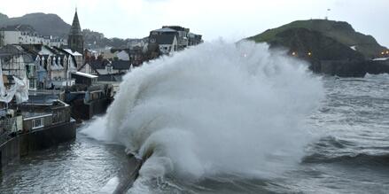
You've doubtless seen the collapsed wall at Barmouth, NW Wales on Sky News, Piers?? Wall collapsed for hundreds of metres as storm surge tide swept over the defences. No houses damaged yet but the flood waters are not far from them. The reporter suggested that another similar storm surge at next high tide might have implications for householders……..
On 03 Jan 2014, Rob Horler wrote:

On a humorous note have a look at this on Watts up with that, great cartoon caption from Josh mocking"the ship of fools" http://wattsupwiththat.com/2014/01/03/friday-funny-the-guardian-and-josh-together-at-last/#more-100421 On a more serious not do not forget to email your Mps and ask why on earth the taxpayer funded BBC felt it needed to be represented on the ship of fools. Remember to copy in a friendly journalist to ensure a reply.
On 03 Jan 2014, Carl 30d Subscriber wrote:

Just read with great alarm that John Hirst the met office guru (or fraudster) and another climate scientist will recieve MBEs in the new years honours list.WHAT AN ABSOLUTE DISGRACE!!.Now it seems you can lie cheat the public and at the end of it get an MBE.I might get one myself if i mug a granny.It now seems the new years honours list has been corrupted.GET OUT CAMERON and put a more honest politician like Nigel Farage in No 10.PS take away their MBEs and give it to Piers Corbyn instead and those who give honest forecasts
On 03 Jan 2014, andy1 wrote:

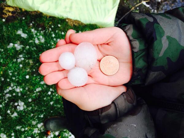
heavy hailstorm in Hemel Hempstead mid Friday afternoon
On 03 Jan 2014, Richard, Jersey CI, Sub wrote:

Hi Piers just adding to reports of sudden thunder and hailstorm here in the channel islands, occurred around 3.20pm. Large hailstones for here !
On 03 Jan 2014, Tony Tony wrote:

As a snow lover wish we would have swapped scenarios with usa as a winter sub I await the rest of winter
On 03 Jan 2014, Jim M wrote:

Hi Piers, Just my own observations but it looks like a similar January to last year in terms of timings i.e. Jan 2013 had an R5+ sometime during 17th – 20th preceded by an SSW. This gave us lots of snow in South-East (I remember making a snow man). Not sure if the coming R5+ around mid-month this Jan will be as snowy as last years, as the SSW doesn’t seem as drastic. Any thoughts?
On 03 Jan 2014, Bob Weber, N Mich USA sub wrote:

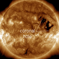
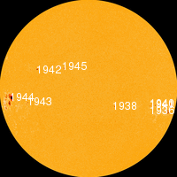
Dittos on UV x-ray blast observations. Informal blog discussions with solar scientist Dr. Leif Svalgaard reveal mainstream doubts (or won't admit?) x-ray blasts contribute significantly to TSI measurements. My investigations thus far cast serious doubts on TSI capacity to capture all solar activity in solar "constant" data sets. If people across the world observe a short-term UV warmth blast, get a mild tan from it, but scientists say it isn't measureable - I have a problem with that. Short of attributing motive, this needs further examination. Active region 1944 may very likely give us another opportunity to register more UV blasts on Earth from x-ray flares, so if people could pay attention for the next 10 days and see if it happens again, we could contribute to a deeper understanding of transient solar activity. Recent USA weather maps and conditions - extreme cold/snow - were precisely foretold by Piers, which ought to be pretty mind-blowing to the uninformed, you'd think.
On 03 Jan 2014, Sue ROI subscriber wrote:

Well I think iii cancel my pitch & putt for the next few weeks so ; )
On 03 Jan 2014, Paul, Bedfordshire (Subscriber) wrote:

The GOES spike between noon and 3PM on 2nd January coincides well with our walk on Dunstable downs yesterday afternoonn. I wasn't burnt, I would say it was a mild skiing type orangy tan on the face, possibly aided by wind. Never had any sort of suntan in early January before in the UK!
On 03 Jan 2014, Paul, Bedfordshire (Subscriber) wrote:

Cloudless glorious sunshine again this morning here in Bedfordshire, alas not for long. Very dark clouds at 11 then a flash of lightning and thunderhail followed by deluge.
On 03 Jan 2014, John Meakin wrote:

Winter subscriber. Well, surprise, surprise. This morning here in Somerset (Ilminster) we had a short sharp and very intense hailstorm with overhead thunder and lightning. I videoed it on my iPad: it gets stronger and stronger pinging all over the place. Power outage as well which killed the Internet for a while. I think we know where all that energy came from! Here is the link: http://www.youtube.com/watch?v=H1TNVaeUZCk&sns=em I have been watching Piers at work all throughout this winter. This hit was a little slow in coming, but here it is broadly as he predicted. Congratulations on your prescience. I sing your praises on Facebook. I also emailed the Environment Agency and asked them to pay more attention to your forecasts. We will see if it makes any difference. Regards John Meakin
On 03 Jan 2014, Paul wrote:

At around 1335 today I heard thunder and saw a flash. At approx 1340 there was a hail storm with hailstones over 3/4 cm in diameter. It lasted for a few minutes. It was the most heavy intense hailstorm for years I can remember. Lowestoft doesn't usually get very severe weather like this so quite unusual for this area.
On 03 Jan 2014, Steve,Dorset,UK (Sub) wrote:

Blimey spoke to soon the clear sky went away replaced by vicious black clouds and squally rain then a bolt of lightning which put the power off, had to reset the trip an hey the sun is out now, blimey it is a stormy day. I wonder is this the sort of weather piers was talking about you could call it cobra weather but maybe we should rename it Corbyn weather. 12:53...... 3/1/14
On 03 Jan 2014, Steve Devine (Sub) Waltham Abbey wrote:

Keeping a close eye on the winter storm exiting NY Friday night and crossing the Atlantic to reach our shores on Sunday night. At one point the storm has an intensity of 930mb at it's core out in the Atlantic. The model output (6z) has the storm losing power and stalling between Scotland and Iceland, but we know otherwise don't we people...!
On 03 Jan 2014, Piers_Corbyn (twitter) WA Forecaster wrote:

GREAT COMMENTS ALL, Thank you. THE IMMINENT STORM IN THIS R5+ STORM TRAIN -Yes SUE - SERIOUS (and some snow too!) - see Comm now in main blog above. There is also another next week but I think we have to be careful to check which one people refer to. CAN WE GET ANY PICS of the foreboding weather in Cambridge which maybe sounds like the Snowmageddon clouds in Chicago on 2nd? - see twitter feed. === BRIGHT SUN & R5 / R4s. See if your extra warmth feelings coincide with the X ray etc blasts on the GOES display above. The UV will go along with X rays largely and note the 'Like ski-ing sunburn' comm is about UV sunburn. Thanks Piers
On 03 Jan 2014, Rhys Jaggar annual subscriber wrote:

Piers Thunder-rain as I type this at 12.30 on 3rd January in NW London - a clap of thunder which just lasted 15 seconds and was accompanied by a torrential downpour. Only lasted a minute or two but was very impressive!
On 03 Jan 2014, Sue, Subscriber, Cambridge UK wrote:

Some stats to back up my observations: In the half hour between 11.30 and 12.00, 2.6mm rain, max windspeed 50 knots, av. windspeed 16.6 knots and most intriguingly, a temperature plunge from 9.2 degrees to 5.2 degrees. Thanks to Cambridge university for the figures.
On 03 Jan 2014, Steve,Dorset,UK wrote:

Wet and woolly this morning with a stiff wind a blowing, rain in the form of showers, the end of the front is just going over after a good blow and storm with a line of blue sky just like someone had drawn a line in the sky between the two sorts of weather, P.S. I see that the chines ice breaker has got trapped in the warmist ice, no don,t laugh they said it was getting much warmer, especially according to the BBC propergander this morning on the radio. Midday here.3/1/14
On 03 Jan 2014, Sue, Subscriber, Cambridge UK wrote:

We've got thunder here in Cambridge now too. Fascinating.
On 03 Jan 2014, Sue, Subscriber, Cambridge wrote:

Wuthering Heights conditions in Cambridge UK. Howling gale, black sky and sleet in large quantities. Don't know about Armageddon but this is looking quite appocalypatic in the short term.
On 03 Jan 2014, Wendy wrote:

45 day sub.HighPeak ,Derbyshire. Other people have remarked upon the brightness of the sun. This morning it is amazing,I don't recall seeing it so bright before.Not much weather here yet,just the odd shower,quite mild.
On 03 Jan 2014, Sue (subscriber) wrote:

Anthony sagliani believes The winter storm Hercules battering Northeast United States will eventually bomb into a ~930mb monster storm west of Ireland/UK this Weekend http://t.co/9kRo6INEP6 Ryan Maue saying the same: @RyanMaue: East coast low moves into North Atlantic during weekend -- bombs out to 933 mb (or lower) w/hurricane force winds http://t.co/BKObVVqdQW What's your thoughts Piers?
On 03 Jan 2014, Lorraine Lister wrote:

Its been a wild day across NZ http://www.stuff.co.nz/national/9573316/Extreme-weather-sweeps-globe Note they mention that the world is experiencing extreme weather right now. On tonight's TV news we were told that Australia had its hottest year ever in 2013 - pity they don't qualify statements like that with the words "since records began". But the breaking news item on our news was that the warmists on board the icebreaker in the Antarctic had been airlifted off (yes that was the breaking news item!). To cap it all off, we had a new Greenpeace TV commercial urging us to save the Arctic which depicted a polar bear foraging for food in a city. Maybe you've already seen that one in the UK?
On 02 Jan 2014, Dave wrote:

Could this winter possibly turn out to be a 1947 scenario? ie, late but harsh I wonder, with everything pointing to cold and blocking mid to late Jan, we will have to see I suppose, I just hope if it does it doesnt bring this country to its knees like it does when you get more than 2" of snow.
On 02 Jan 2014, Maria 45day sub somerset wrote:

snowpocalypse. Bang on target yet again. Wd Piers http://www.dailymail.co.uk/news/article-2532566/Freezing-cold-blizzards-grip-Northeast-Canada-records-temperatures-cold-Mars.html Cobra has been meeting today, yet meto forecasts are still insipid. How many more lives have to be lost and properties damaged before the uk wakes up to the lia warnings. Frustrating beyond belief
On 02 Jan 2014, Gerry N Downs 600ft 45d wrote:

Well the sun shown over London today until some cloud appeared late afternoon. And with the sun, we boiled in our office again. Mid-winter and we have the cooling fans going. Is the sun having a greater effect as per earlier comments as I don't recall it being as hot in the office last year. The rain kept coming until gone 1am and the Mole Valley south of the Downs had more flooding although less than before Christmas. One comment I forgot to mention re Christmas Eve flooding were two people saying that they were surprised that there wasn't more warning then. And the Met O receives £240m to do what exactly? The BBC prat rescued in Antarctica commented that he hadn't expected so much ice. Obviously spent too much time listening to his own employer's BS no doubt.
On 02 Jan 2014, Paddy (Aberdeen south, 130m elevation, sub)) wrote:

Overnight temp 4˚C, and after an overcast start the day brightened up as it went along, lovely cirrus clouds overhead & occasionally bright sunshine (can't say whether it was any brighter than usual, there were too many clouds), temp rising to 6˚, moderate SW breeze, it was a great day to be out. By mid-afternoon, cloud cover increased from the west, so any chance of seeing the possible aurora was gone, ditto for tomorrow by the looks of it. Temp back down to 4˚ by 9pm. The Atlantic low now approaching Ireland looks like it could be the sting in the tail of the R5+ which finishes today, or tomorrow, given the +/- 1 day rule.
On 02 Jan 2014, justin wrote:

hey Piers - why are we getting speeded up jet stream and why are we getting so much blinking wet weather?
On 02 Jan 2014, Bob Weber, N Mich USA sub wrote:

private for Piers: Please upload all Dec 2013 forecasts for the public to review ASAP. thank you for you everything you do
On 02 Jan 2014, Wayne Kerr wrote:

Dear Sir, I believe in AGW and will continue do so for as long as the voices in my head tell me to!
On 02 Jan 2014, Paul, Bedfordshire wrote:

I had the horrible foreboding feeling again mid morning, at much the same time as the sun became incredibly intense and light flooded in. Now I see there are 11 severe flood alerts. Seems the foreboding was indeed a protective instinct.A walk on the downs in the intense Sun resulted in my face having a slight orangey tan like you get after Skiiing. Is it me or is the light from the Sun today more like the southern hemisphere in Summer than UK in winter. It was exceptional.
On 02 Jan 2014, Bob Weber, N Mich USA sub wrote:

Well said Piers. NO QUARTER. I've said to my lady all of 2013 that when the warmists fully understand the implications of electric and magnetic weather effects like WeatherAction does (Piers & Co & customers) the warmists are going to crawl in bed and cry to their mamas for sympathy for their blatantly obvious stupidity. BTW "No Quarter" is part of the message of my new "The Electric Weather Channel" YT video out soon - are we not on the same page? It's time for the world to turn the page and terminate CAGW forever as it is an invalid premise without predictive power. When the dust clears, the warmists will have a lot of long-delayed soul searching ahead of them. For 10 years I have worked towards a thorough understanding of electric weather, thinking I was the only one in the world who knew about this, until I found WeatherAction. A realization came upon me in early December 2013 that I did not discover electric & magnetic weather effects caused by solar action, Piers Corbyn did.