On 02 Jan 2014, Dave wrote:
Could this winter possibly turn out to be a 1947 scenario? ie, late but harsh I wonder, with everything pointing to cold and blocking mid to late Jan, we will have to see I suppose, I just hope if it does it doesnt bring this country to its knees like it does when you get more than 2" of snow.
On 02 Jan 2014, Maria 45day sub somerset wrote:
yes Steve, I had to laugh out loud. They said last night `the ice is thicker and that is a surprise to us` WA could do with making more of this
On 02 Jan 2014, Steve,Dorset,UK wrote:
What a stormy day yesterday gale force wind and driving rain all day right through till the Evening, Mild though, This morning total contrast starry skies early this morning and thank goodness DRY. I am so pleased that the global warmist on the ice trapped ship in the Arctic are being taken off by helicopter they now know what real ice actually looks like and even with a BBC spin doctor on board have Frozen Egg on there smug faces.
On 02 Jan 2014, Russ 45day Derbyshire subs wrote:
Paul, Bedfordshire.... That feeling of foreboding is probably what we call 'instinct' in animals. The observations of animal activity changes just before thunderstorms or earthquakes are what we term 'instinct', but if these are caused by solar activity, then we can only assume that our own changes in behaviour, including emotional changes like foreboding, will be triggered. I think that we do still have these fight or flight instincts just like animals, it's just that we haven't needed to use them for so long, that we don't recognise them when we get them. All this double-glazing and central heating has made us soft and unresponsive to the external signals that our forebears used to rely on to survive.
On 02 Jan 2014, Lorraine Lister wrote:
@Gill 1066 Hastings - The even more hilarious part is that on tonight's TV news in NZ we heard that the helicopters can't get in to rescue them from the ship either. We've had this story fed to us on TV night after night and have been amused by the comments from those on board. Being committed warmists I suppose they didn't think it necessary to check sea ice etc. before continuing their voyage. A few days ago I felt sorry for them but now that I've learnt who's on board I don't. Oh well, they'd better keep trying to rescue them because the Antarctic summer ends in March and we're already in January!
On 01 Jan 2014, Robert-Michel (Montreal, Canada) wrote:
The following comment from a weather expert in the US seems appropriate right now: "The dangerous cold coming is far more of an extreme event to me then a snowstorm that produces for better words, typical snowfall for New England and the Mid-Atlantic in January. More people will suffer from the extreme cold then the snowstorm." Let's wait and see...
On 01 Jan 2014, Paddy (Aberdeen south, 130m elevation, sub)) wrote:
Clear start with a few clouds, still a good S breeze, overnight min temp 3˚C, sunny for a couple of hours then clouding over, wind increasing, rain starting around 4pm, wind gradually increasing, by 7pm lashing rain & howling wind, all from a S SSE direction. Temperature rose to 6˚ during the day, by 9pm it was at 7˚ and the wind had abated somewhat, MO forecasts 9˚ by midnight. I hope we get enough clear slots to observe the coming auroras. I'm not too unhappy about the lack of snow, I have to say. @Bob Weber: I'm south of Aberdeen, Scotland, not South Dakota, over there they've certainly got snow big time it seems.
On 01 Jan 2014, Gerry N Downs 600ft 45d wrote:
New Year greetings to all who come to Weatheraction. Wet and windy was Pier's forecast and that is what it has been here all day. At 6pm ITV weather presenter Sian Lloyd pointed to a chart showing the rain that had been over the south. Well, not necessarily 'had been' since at 9pm it is hammering down again!! I can only hope the weather hasn't hampered the Brighton mainline rail works because if they aren't finished by morning, there will be a lot of unhappy commuters. The antarctic pantomime continues with the ship issuing a request for weather information that ended up with Anthony Watts - see him interviewed on the link provided in an earlier post. Ironic they end up getting help from one of us non-Warmists. Probably wanted to know what is really happening down there.
On 01 Jan 2014, Paul, Bedforsdshire, (Subscriber) wrote:
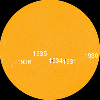
AR1936 has just launched an M9 flare
On 01 Jan 2014, Robert-Michel wrote:
From Montreal, Quebec, Canada:
Happy and prosperous New Year, Piers. Much hyping in certain circles about a storm in Southern New England during the next few days. Actually, it's rather about "pockets" of heavy powdery snows. And as one weather wizards writes: - "New ECMWF just came in. Storm much weaker and less QPF. Just a flat wave heading off the coast." - No way a snowageddon yet! Maybe for the fishes... But watching and waiting for your January outlook. Warm and friendly handshake from Quebec where we are battling with a deep freeze (-30 C predicted tomorrow night).
On 01 Jan 2014, Piers_Corbyn (twitter) WA Forecaster wrote:
NOTE ALL- EURO REGION MAPS IS UPLOADED but there is something wrong with updating this blog (text above) hence this message. Thanks Piers
On 01 Jan 2014, Piers_Corbyn (twitter) WA Forecaster wrote:
AND B - Yes - subscribe under the button for 12 where charge is now 8 and we extend for 12 from where you are - taking you to Feb 2015. New year greets and happy weather applications. Piers
On 01 Jan 2014, Ben (45D sub, Forres) wrote:
Applogies I too should check before submitting! the 5th December 2013 did bring havoc to North Sea coasts with winds running parallel to the coast, from the North coupled with the spring tides. That was the exception they have been mainly come from the West.
On 01 Jan 2014, Ben (45D sub, Forres) wrote:
cont.. time consuming, and of course some regions will be more successful than others. Nevertheless one based on the UK as a whole would be useful not just to subscribers (who could do it themselves if so inclined) but for potential subs. There is one 30d Uk & IRE forecast that stands out for me from 2013, it was July's "Unsettled, wet and cool in most parts. North / South contrasts, S England often finer, strong N/NW'ly cold blasts especially after 12th. 2 major wet and windy spells including the south, with thunder flood, damaging hail and tornado risk." Piers did add comments later in that month, but that was one forecast I was glad did not pan out as forecasted!!!!! For pretty much the whole of the UK for atleast 3 weeks. I'm sure many others did too. That said there has been some notable successes throughout the year, but what percentage? What will 2014 bring? January looks interesting will there be a colder influx of air in the R5+ period later in the month, will we get any easte
On 01 Jan 2014, BLACK PEARL wrote:
Oh the irony...
http://www.kusi.com/video?clipId=9686594&autostart=true
Happy New Year Piers & all
On 01 Jan 2014, Ben (45D sub, Forres) wrote:
Happy New Year everyone! Just a couple of thoughts I felt needed sharing... Firstly the UK winter so far, For many it has been diabolical what with the floods and gales and power outages and all the inconvenience that comes with it. In terms of cold and snowy, nothing out of the ordinary. Yes, the high ground of the UK has received plenty of snow, more especially the Scottish Highlands like Glencoe mountain ski resort, which has been open for a few days. Nothing unusual there then based on the last few winters. And bear in mind the winds have predominantly been of WSW origin for weeks now, with some returning polar maritime at times. N or NE winds non existent thus far, so little chance of Snow south of the border. Will that change in January 2014?
Secondly, I think that this has perhaps been mentioned before.. But I think a review of the previous years successes and failures in terms of an overall average percentage rate is useful. I appreciate that it would be complicated and time
On 01 Jan 2014, Andy B 45D Farmer sub SE Wales wrote:
We received approx. 295mm of rain in December must be way over average for Monmouthshire
Piers I have emailed you, text you and DM you on twitter but no reply. Can I take advantage of12 for 8 offer as my 12 mth sub does not run out until February?
On 01 Jan 2014, Gill 1066 East Sussex - subscriber wrote:
Forgot to say, check this out. A DM journalist seeing the light?
http://www.dailymail.co.uk/news/article-2532013/A-dose-COLD-reality-The-ironic-saga-eco-campaigners-trying-highlight-global-warming-melting-ice-caps-trapped-freezing-Antarctic.html
On 01 Jan 2014, Gill 1066 East Sussex - subscriber wrote:
First the good news.... Spring must be on the way - the first lambs have arrived (3 to date). The not so good news is that the fields are saturated. Many farmers out-winter their livestock which means fields are getting poached - and because the grass is so wet stock need feeding hay or silage on a daily basis. After the disaster of 2012/13 we put up another new building last year so we are lambing inside without being full to the rafters like before, and we have been able to store extra fodder and can house all our animals. Others will not be so lucky. Farmers up on the chalk downs may have it slightly easier , but down on low lying ground fields have become lakes. The local lanes are taking a pounding with all the water flowing over them and with a daily milk lorry using them, pot holes are getting bigger. However, if the councils kept the drains free and cleaned them out once a year the problem would not be exacerbated. The EA is happy to target farmers but not councils.
On 01 Jan 2014, Steve Devine (sub) Waltham Abbey wrote:
2pm in Waltham Abbey, Essex and the rain has been torrential for the last hour with winds gusting to 50mph. According to XCweather.co.uk, there are currently gusts of 55mph at Stansted Airport and 65mph on the south coast. According to the radar, there is a second and (worryingly) more intense hook of heavy precipitation currently slamming into SW England and all heading across southern England as the afternoon progresses. Expect winds to be squally until well after dusk folks.
Piers - I've just read your Jan forecast. Am (as always) taking note and precautions where necessary for travel arrangements.
Happy New Year to Piers and all who support WeatherAction.
On 01 Jan 2014, Paul, Bedfordfshire (Subscriber) wrote:
I can't shake off a horrible foreboding feel at the moment. Currently pressure falling very fast 2.2mbar per hour, wind increasing and the effects of last nights M6 are starting to be felt the last hour with KP up to 3 albeit still quite low.
If piers is right that solar activity powers up storms, I wonder if the feeling of foreboding is due to the magnetic field being felt in the brain and therefore we have evolved to feel foreboding at such times to encourage us to seek shelter?
Happy new years
On 01 Jan 2014, Piers_Corbyn (twitter) WA Forecaster wrote:
TOP AND PROSPEROUS NEW YEAR TO ALL AND THANK YOU ALL for a great year of Comms and support for WeatherAction success. Yes I agree a New Year Res, apart from Warmistas Delanda Est, is improve typos in Comments == Question RUSS Good point about clean dry polar air giving brighter to feel Sun BUT for you there has been not much dry air and maybe not very clean either so although the extra warmth might be as you suggest, is there more to these reports of 'warmer' sun - more UV with solar activity, eg? === ALL Keep diligent storm watching today and again Thursday-Friday - all in 1-3rd time window. Good top wind reports on twitter feed. === ALL See that NY 12months for 8 offer - ends on 12th night so please pass it on. Thanks
On 01 Jan 2014, Lorraine wrote:
Thank you for the January report Piers most interesting keep up the good work :)
On 01 Jan 2014, Russ NE Derbyshire subscriber wrote:
The rain is seriously hammering down and the wind strength has increased noticeably over the past hour, now 12 noon Jan 1st.
On 01 Jan 2014, Russ NE Derbyshire subscriber wrote:
Stephen Parker..... There is one particular field we pass almost daily about 4 miles north of Chesterfield, Derbyshire, which has sat waterlogged since about the end of October. So long ago now I can't remember exactly, but the past couple of days, with all this rain, the field's standing water has increased by around 100%. The farmer hasn't planted, but left it as stubble: a good move! The moor where we usually walk the dog is so muddy we've given up for now and travel an extra mile to find solid well drained ground. .......... Bob Weber... I have also noted, as have others, that the sun has been extremely bright some days, but put it down to clean, dry, polar air.
On 01 Jan 2014, stephen parker subscriber wrote:
Most models now calling for cold from around the 10th (fwiw), but too far out for any detail, so us snow lovers may get our wish!. At least this wet weather means the GW bed wetters wont be bleating on about drought for a while. Any farmers out there who can tell me how this weather is effecting their crops/livestock? The mud must be a nightmare!
On 01 Jan 2014, Gill 1066 East Sussex - subscriber wrote:
Happy New Year everyone. Just seen the Jan 30d. It confirms why I see buying a WA forecast as a necessity, and not a luxury.
On 01 Jan 2014, Rhys Jaggar wrote:
Interesting forecast for January - reminds me a bit of January 1991 in terms of the sequence of depressions.
Would you agree that your forecasting skill in December over quite a few years now seems remarkable whereas some other months still have challenges remaining??
On 01 Jan 2014, Bob Weber, N Mich USA sub wrote:
Happy New Year all. First resolution: correct grammar and typos before hitting submit button!
Second: keep making observations & encourage others to do the same. I wish more commenters would give their location. Its helps to know.
On 01 Jan 2014, Bob Weber, N Mich USA sub wrote:
Rohan you said yoday, Dec 31: "Also I have noticed (again past 2 or 3 days) that the sun has been most unbearably bright, even brighter than on a clear hot summers day!" I wish to relate to all the same EXACTt observation from near the 45th parallel in N. Michigan.
On 31 Dec 2013, Paddy (Aberdeen south, 130m elevation, sub)) wrote:
Dry start as such, though everything is dripping wet and the ground is pretty saturated, 1˚C overnight minimum, then rising to 6˚ most of the day. Stiff S breeze early on, by 9am it picked up to probably about gale 6 and kept going most of the morning and into the afternoon, only calmed down by evening. Rain started at midday and kept going until about 4pm, not nearly as heavy as yesterday, thank goodness. The evening was pretty clear again with many stars out, 4˚ by 11pm (yep, I'm allowed to stay up late once a year :-)) Happy New Year to everyone!
On 31 Dec 2013, Russ 45day Derbyshire subs wrote:
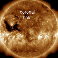
When it stops raining the temperatures drop. Only when the rain fronts pass over has it been comfortably mild here in the Peak District. The late evenings and early mornings have been bitterly cold this past few days. We are off to walk the dog on the moor (8.20pm) and we are certainly going to wrap up warm. Just a couple of degrees will tip the balance and the Coronal Hole is now spewing it's new year particles at the Earth. We should get great aurora even if the snow comes late.
On 31 Dec 2013, Dermot (occ subscriber) in Tasmania wrote:
Happy New Year from Australia. There is an interesting article in one of the main newspapers here, having interviewed the new government's chief business adviser, Maurice Newman. He highlights support for the Mini Ice Age forecast and completely rubbishes Australia's fascination with global warming. This must be the first example of a G20 government switching to the rational side of the climate change debate.
Mr Newman said Australia had become "hostage to climate-change madness". "And for all the propaganda about 'green employment', Australia seems to be living the European experience, where, for every 'green' job created, two to three jobs are lost in the real economy," he said.
"The scientific delusion, the religion behind the climate crusade, is crumbling. Global temperatures have gone nowhere for 17 years. Now, credible German scientists claim that 'the global temperature will drop until 2100 to a value corresponding to the little ice age of 1870'."
Any chance of an Oz se
On 31 Dec 2013, BLACK PEARL wrote:
Julia Slingo being made a Dame in the New Years honours
A reward for towing the 'climate change' political line ?
As a Dame does that mean she'll be getting lead parts in even more pantomimes :D
On 31 Dec 2013, Rob Horler wrote:
Happy new year all. For what it is worth I am more than happy with the new year forecast. As A Munro compleatist I use Piers forecasts to determine whether I will make the long drives North to head into the hills. If you look at the MWIS forecast for the next three days its pretty much ties in with Piers forecast. Remember a degree or so makes a lot of difference.
http://www.mwis.org.uk/wh.php
Incidentally any of you who wish to view the Glencoe Mountain website will see just how much snow is already there, a warmists dream!
On 31 Dec 2013, Rohan (sub) Hackney, London wrote:
hmmm... well from what I can see on spaceweather, the solar activity is being a bit tardy with its escalation so Piers forecast may come a bit late. Nonetheless, it has been noticeably colder here where I live for the past couple of days, not mild at all. Also I have noticed (again past 2 or 3 days) that the sun has been most unbearably bright, even brighter than on a clear hot summers day! I believe in Piers methods and even if by a couple of days, his forecast will happen. Keep the faith
On 31 Dec 2013, mark manchester wrote:
You can't be right all the time and more often than not you are correct. Really do hope we get snow at some point and when we do I feel your forecast will be correct all be it a tad late
On 31 Dec 2013, larkduke subscriber Kildare wrote:
The wizard of weather, we wait patiently, any sign of the January forecast? Tapping my fingers in eager anticipation.. kudos so far..
On 31 Dec 2013, Gill 1066 East Sussex - subscriber wrote:
Lorraine, I too am slightly confused. I purchased an annual 14 month sub offer 30d last march to run till April next year. I upgraded to a six month 45d offer last summer which has now expired. As I was unwell before / over Xmas and coupled with the power cuts we had down here I missed out on all the offers. However, now I do not if my original 30d to April still stands, and if I can get January, and if I did upgrade again - when is my renewal date.
On 31 Dec 2013, Lorraine wrote:
Happy new year Piers
I can't get the hang of this purchasing a forecast, I bought the one that says end December and you get the month of January updated Dec 31 but when I go in as a subscriber I only get the December forecast, have you updated it yet Piers as I am little Miss Desperate x
On 31 Dec 2013, Maria 45day sub wrote:
I kept telling family about the `snow` I banged on and on about being prepared but just now I am keeping my head down. I did tell them about the multiplying effects of R5 and we are definitely more windy and wet than met o was saying. I understand the importance of R5 periods but that is something I am going to emphasise more to family, rather than specifics like snow because all they see is the word `snow`. No egg on my face just a bit of disappointment for PC rather than for me, snow everywhere would have given this site such a boost
On 31 Dec 2013, Grant wrote:
Hi Piers
I appreciate that you have made a comment stating that the 30d forecast has changed from the 45d forecast. You refer to days 1-3 but can you confirm what this change is. My business subscribes to your services and any changes to your forecasts make a huge difference to us even if they are short range changes. Regards
On 31 Dec 2013, Steve Devine (Sub) Waltham Abbey wrote:
Another day passes, another round of model output churned out. Still showing a stormy and unsettled picture for the foreseeable future with winds mainly from the West, occasionally veering NW'ly. The storm tomorrow looks like being matched by one battering Ireland and Scotland on Friday, but then us WA fans know that tomorrow's storm will be worse than the MoBeeb and output models tell us.
The only support I can see for snowfall would be as the front crosses the country tomorrow, bringing snowfall as far south as the Pennines, but not much scope yet. Time will tell. From past experience I'm placing my faith in Piers!
On 31 Dec 2013, Lorraine Lister wrote:
More on Cyclone Christine in Australia http://www.stuff.co.nz/world/australia/9565905/Cyclone-hits-with-170kmh-winds
On 30 Dec 2013, Paddy (Aberdeen south, 130m elevation, sub)) wrote:
Looking at the radar sequence and judging from the relative lack of puddles, our NE area does not seem to have had so much rain overnight. But it didn't half catch up from about 9am onwards, going on, on & on. I have no rain gauge but when our veg tunnel gets flooded in spite of all the drainage improvements we made I know it's serious stuff. Temp 6˚C morning & all day, then down to 4˚ by 9pm, feeling decidedly chillier. The wind has been anything from SW SE NW by evening. Todays weather maps are moving towards what Piers predicted 6 weeks ago. Now waiting with bated breath for developments over the next few days, no amber or red warnings to be seen on any MO page so far.
On 30 Dec 2013, Lynne (subscriber, SE Wales) wrote:
Hi Piers, saw your note today on the comments about the first period in January changing in the 30d forecast compared to the 45day, but I can't see the 30d forecast yet in the subscribers' download area. Can you load it before 5pm tomorrow? Lots of us will be at New year parties tomorrow night - a great opportunity for plugging WA forecasts! If the first period of Jan has changed significantly, it would be good to know what's changed to avoid egg on face and undermining confidence in your forecasts. Congrats on Dec by the way, great forecast so far, most impressed! But seriously wishing for some snow....
On 30 Dec 2013, Piers_Corbyn (twitter) WA Forecaster wrote:
KARL - Northern Lights I saw them once in Wiltshire on an amazing summer night when I was busy making a corn circle (which fooled the locals btw) I became aware of a glow and looked up HIGH to the North. It was totally wow and blessed the Corn circle. === SHAUN another thing these people have very little understanding of reality let alone manners. They say because they believe we havnt published all of HOW we do it then it's not science. Well therefore RADAR invented by UK WWII was not science, Your mobile phone and the aeroplane you fly and F1 racing cars which are full of secret (science) are therfore not science and not to be trusted so then throw away that Ipad, dont fly, dont drink coca cola....Amen
On 30 Dec 2013, Piers_Corbyn (twitter) WA Forecaster wrote:
SHAUN, re Netweather, thanks for making the time to say something. Yes you are right some of them are totally pathetic and judge by double standards. Most of our forecasts are once only and these pathetic can't do - don't understand - won't read - list our mistakes but MO when its wrong 4 times until the day is OK. Ours are the ONLY long-range forecasts with independently judged peer-reviwed pubished proven skill - see forecast accuracy on website. And as for qualifications I have loads: 1st class physics Imperial College (Royal Scholar, came top of class in first term exams), astrophysicsist, taught Electromag in Univ They appear to be driven by burning envy and a mentally limited belief that the more people you attack and denigrate the better person you become. If any want to discuss they can come to our open monthly meetings but they never do. We invited MetOffice and greenies to meetings but they never came. Anyhow by you writing some might read who say nothing, so thanks, Piers
On 30 Dec 2013, Karl (oc sub) wrote:
Looking forward to the informed version as opposed to the met office version of how New Year's Day will pan out. Also, does anybody know if there is a boundary of how far south you can see the northern lights? I've never seen them!!
On 30 Dec 2013, Russ NE Derbyshire subscriber wrote:
Just realised....... Venus, Saturn and the New Moon are on the same side of the Earth around New Years Day. If those sun-spots go pop we could have some fantastic New Years Day aurora. Fingers crossed for clear skies...
On 30 Dec 2013, ian wood wrote:
thanks russ
I have been watching piers making many accurate predictions and am learning constantly....
much appreciated piers,you sharing your knowledge....
i also keep a close eye on planetary movements from the earths and suns perspective....all seem to be connected...
On 30 Dec 2013, Russ NE Derbyshire subscriber wrote:
>>> http://vitaminl.tv/video/1673 <<< So fit some larger wings, and an even bigger fuel tank, then fly it over the area you want rain, and Bob's yer mum's brother. A bit expensive though....but a great idea for keeping the Shuttles useful and actually earning money instead of rusting/corroding away.
On 30 Dec 2013, Russ NE Derbyshire subscriber wrote:
ian wood.... If you monitor Piers closely, you'll find that he seems able to predict changes in solar activity just as accurately as he predicts changes in the weather. I personally believe that this pole flip will cause changes in the weather, but maybe more dramatic changes than usual after a pole flip because the Sun has been so inactive for the past 10 years. The Solar Max has been very weak this time, which NASA experts didn't expect. They expected a weak max', but misjudged by about 50%. I'll be interested to see if the flip has an effect on the position of Earth's magnetic N Pole. Watch the Earth facing Sun-Spot AR1934 and the big Coronal Hole which will be facing Earth in a couple of days. That should hot things up a bit! Human behaviour could be suppressed or exaggerated, so watch for people close to you throwing a wobbler... Also New Moon on Jan 1st so weather should get wild...erm...wilder? Saturn will be almost aligned with the Moon as it reaches New Moon too 28th - 29th...
On 30 Dec 2013, steven glossop wrote:
Hi, Piers.
Just a reply to a comment made by Shaun. I agree with you Shaun. These few! people who make these comments are ignorant and rude. If mistakes are made then its a complex subject and Piers will be honest and explain why. But the December forecast has gone very well. So even if we don't get then snow around new years' day. The general theme of the weather this month has been correct with frequent storms. Ignorant people should just be ignored. They will soon get bored.
On 30 Dec 2013, Gerry N Downs 600ft 45d wrote:
Strong winds certainly make for changing weather as at 2pm looking out over Westminster from 10 floors up the sun is out among the clouds and the wind speed has dropped. Such a contrast to the howling wind for most of the morning along with some rain but not as heavy as last week. Still caused the windows to leak though. V hard frost on the Downs yesterday morning and a sunny day. All we can do now is watch the sun, check the forecasts but be aware of how wrong they might be.
On 30 Dec 2013, ian wood wrote:
a calm bright day so far in s. Kerry....wary of this coming r5 as my polytunnel has been taking a battering in the previous storms...
On 30 Dec 2013, Shaun wrote:
http://forum.netweather.tv/topic/78310-winter-2013-2014-discussion-part-2/page-109
Seem to be getting a bit of a slating on Netweather Piers. Not that I expect you to care what some ignorant people think... it's just that I find it highly amusing how people try to debate scientific theories in a very complex scientific field such as weather all seriously... and they don't see the contradiction to science they themselves are when they make puely speculative ignorant assumptions about your ability. While some in the same sentence admit not having seen your forecasts claim how poor your accuracey is. I mean can you slate someone without knowing anything about them other than bias ramblings from usually jealous individuals
I did stick my nose in and stand up for you, but it seems there are more happy to be ignorants than happy to test your ability.
On 30 Dec 2013, Michelle wrote:
Wind seems to be picking up here on the east coast, wasn't so windy this morning but rainy.
On 30 Dec 2013, Rob wrote:
This approaching New Year period is possibly the most fascinating weather period since I discovered Weather Action 3 years ago . I don't think I 've ever seen the models so opposed to what Piers is saying. There is more of hint of strong winds showing now in the charts but nothing on the scale WA are talking about. With sun looking like it is about to go bang big style looks like thing in the standard forecasts will change massively and rapidly. Interestingly I see that despite the snow parts of USA have had the Californian ski resorts are struggling Squaw Valley had a temp of 52F which is about 12C I think, certainly too warm for a resort that normally gets several hundred inches of snow.
On 30 Dec 2013, Tracey wrote:
Wish I had the funds to subscribe. My son commutes to work by motorbike. I scour the net for weather information for him and sometimes pick up snippets from Piers and this forum. All my life I assumed my hometown of Hartlepool had its own weather system because the MO was so consistantly wrong. They say light cloud for today and 23 mph winds ... Its actually blowing a hoolie and raining ~sigh~
On 30 Dec 2013, ian wood wrote:
I have just seen reports that the suns magnetic field has flipped(mid cycle)and im wondering if this will have any effect on the weather?
On 30 Dec 2013, JohnE (winter subscriber) wrote:
What I find very worrying indeed is that Piers has forecast a severe storm over the new year period and the MO only have a yellow warning out for wind and an amber for rain, both in fairly restricted areas. There will be thousands of folk travelling over this period and that for me is very worrying indeed. My family are only going a half mile or so tomorrow night and plan to walk but if the brown stuff hits then we may take the car and leave it over night at the venue but for many others it aint going to be that easy. To me this is what the longer range forecast is all about, allowing people to make plans
On 30 Dec 2013, Richard .T.(45DAY SUB) wrote:
No sign of any thing Piers Has forecast for the start of January,if this comes off it will make people wise up to Piers ,the models,the met and the bbc are blind to see things on a computer ,Come on Piers we are behind you.
On 30 Dec 2013, Paul, Bedfordshire (Subscriber) wrote:
Spaceweather now forecasting auroras on 2/3 Jan. My local Met weather forecast for 1st Jan on Sat was sunny intervals AM/light rain PM. Now (as at Mon AM) Heavy Rain all day on 1st Jan with increased wind speeds over Sats forecast. Only the snow to come now...
On 30 Dec 2013, Lorraine Lister wrote:
Wet and windy day across much of NZ but we now have sunshine. Very warm temps. Meanwhile in Australia cyclone Christine is intensifying
http://www.stuff.co.nz/world/australia/9564493/Cyclone-warning-for-Western-Australia
On 30 Dec 2013, Craig M (@CraigM350, Berks sub) wrote:
Slight correction from prev comment regarding tonight's system. For clarity this is from the Chief Forecaster's assessment "An active frontal system will move eastwards across the UK during Sunday night and Monday. Very strong south to southwesterly winds will develop, with gusts of 60-70 mph likely within the area of the Warning, particularly near coasts and over high ground with a low probability of a short period where gusts could reach 80 mph at exposed locations in the Isles of Scilly, Cornwall and western parts of Wales." +++ @beefyfarmer on twitter highlights "An excellent report [to UK Parliament] by Donna Laframboise on IPPC" PDF download link === http://t.co/4R5a9EQ2wa === it is a MUST READ and worth showing to warmish friends. Maybe they might begin to have doubts about the 'scientific consensus' and see the 'political agenda' for what it is.
On 30 Dec 2013, Craig M (@CraigM350, Berks sub) wrote:
A belated Merry Christmas to all & a Happy New Year. May 2014 be the nail in the coffin of a theory long past its Use By Date. +++ the two stormy periods to plague us over the coming days do not appear that bad according Met O & models. MetO go for 50-60mph gusts for both instances but tonight have a low probability for 80 in isolated places (see link for screengrabs and quotes). Main concern is cumulative rainfall & what the warnings are mainly for *at this stage* with ~50mm in places. As this is a strong R period (R5+ for NY) be prepared & watch closely. Our star has suddenly stirred with complex sunspots (x-flare potential) & we have a rather large coronal hole about to pass centre disc + a new moon coming ===
http://bit.ly/18SvsaQ ===Interestingly Gibby's model summary (see prev link) points to a cold N flow following the NY system. +++ Beautiful thick frost this morning lasted till afternoon in shaded areas & early frost tonight before winds picked up
On 29 Dec 2013, Richard Brown wrote:
Piers, I am really worried! My parents are travelling up to Scotland on New Years Day from Hull on the east Coast. Your warnings have been shown to them but they are firmly in the Met Office camp......Really worried.....
On 29 Dec 2013, Malcolm wrote:
I listen to Classic FM and the news on Sat morning came on about the recent storm. News reader said (approximately) "and with more storms to come according to Piers Corbyn of weatheraction" then a brief word from Piers. National radio station,not bad.
On 29 Dec 2013, Asim subscriber wrote:
Hi, piers it says that the first few days of January is going to snowy, even in south east?? Is that still on the cards?? Or is it just going to be stormy wet? As BBC and no saying more rain? R u going to be right?
On 29 Dec 2013, Paul, Bedfordshire (Subscriber) wrote:
Important. Spaceweather reporting that sunspots AR1934 and AR1936 have more than doubled in size over last 24 hours. Game on?
On 29 Dec 2013, Paddy (Aberdeen south, 130m elevation, sub)) wrote:
Clear start, -1˚C at 7.30, hardly a breath of wind, gradually rising to 4˚, a gloriously sunny day with various forms of cumulus clouds in a light SW breeze, the frost stayed on the ground in many places until evening, when temp was 1˚ but around 9pm it rose to 4˚ again and the rain set in. MO announcing heavy rain all day tomorrow, amber warning for Perth & Angus.
On 29 Dec 2013, Nino VAN EECKHOUT wrote:
Subscriber. Saw a very interesting documentary tonight concerning the effects off global warming on nature. Since years we hear that the Great Barier Reef is suuffering from global warming and that it is getting smaller every year due to the warming of the local sea. No in this documentary of tonight to local experts on the GBR were asked how the reef is suffering from GW and they were very formal. They don't see any effects of all. As a matter of fact they said the GBR is doing better than ever and they believe it'll still be there in a couple of 100 years. Now how's that for a kick in the ase of the CO2 delusionists ?! Another proof people try to sell us a lot of crap to enforce us theyr lies !
On 29 Dec 2013, Steve Devine (sub) Waltham Abbey wrote:
Well just before I watch "Tim from the Office impersonates Bilbo Baggins Part Two", just thought I'd share my thoughts on what the GFS models make of next week. In short - underplaying it and clueless beyond 3 - 5 days out. I've been watching the outlook models and believe me, they're never consistent beyond 3 days out. Now that we know SSW is occurring and we're entering a R5+ period, I expect all hell to break loose in line with Piers' predictions. New Years Day could be a hangover from hell, especially for those still mopping up after recent flooding and being without power over the Christmas period. How disgusting are these energy providers eh?
Hope it all pans out as expected Piers!
On 29 Dec 2013, Gary wrote:
I wonder with SSW we will get the term MAJOR SSW everything's a brewing for it! So if we switched to easterlies I wonder what would happen ?? when we seem to get easterlies we really do get a lot of snow across London and southern counties of England!
On 29 Dec 2013, Sue H, N, Ireland (part-time subscriber) wrote:
Hi Piers, I appreciate your info on this coming storm. As a non-weather person, can you explain why this storm will bring the snow whereas the other storms didnt?
On 29 Dec 2013, Shaun South Wales (non subscriber) wrote:
http://www.metoffice.gov.uk/news/releases/archive/2012/improved-winter-guidance
Seems the Met O are back into the long range business. Probably buying Pies forecasts lol... they are saying since the bad winter of 2010 they started using a new forecasting system that tries to predict SSW's.
But if they have been using this new system for long range SSW forecasting with success as they claim, since 2010... then how come last year Piers posted a red warning for Snow in South Wales weeks early and the Met O only gave a tred warning the night before. They didn't even have a warning 5 days before, but it started as a yellow warning, upgraded a day or too later to a amber warning and so on. Must admit, as they are calling it a long range forecasting system, pretty awesome they were able to catch that bad snow fall a day early and was able to actually give a sensible warning to the public with that red warning... because 12 hours before is really long term. I suppose for them it is anywa
On 29 Dec 2013, Shaun Faulkner (South Wales - Non Subscriber) wrote:
@John E. There was snow in parts of South Wales. Granted it wasn't enough to write home about but Christmaw morning there was snow lying on the ground in a town called Fochriw and Deri as I had to pass through on my way to my parents. Higher ground that surroundings towns and often get snow before others.
On 29 Dec 2013, Lorraine Lister wrote:
Some wild weather in the North island of NZ http://www.stuff.co.nz/national/9561350/Wild-weather-leaves-mark-on-North-Island. Right on cue in this R4/ R5 period.
I feel sorry for the people stuck on board the ship in the Antarctic ice but at the same time can't help smiling at the lunacy of the expedition. Must have believed that the summer ice was less than it is down there but maybe they should have checked before setting out on their voyage.
On 28 Dec 2013, Paddy (Aberdeen south, 130m elevation, sub)) wrote:
Cloudy & dry start, 4˚C at 7.30, rising to 5˚, the sun appeared for a short while between the sea and the cloud cover and then was absent for the whole day. Mostly stratocumulus with a strange mammatus-like formation in early afternoon, it came in long 'sausages' rather than the usual bulbous bags. Constant stiff WSW breeze, a bit calmer tonight at 9.30pm when the temperature was 0˚ under a now clear sky. - Can confirm that MO is showing absolutely no warnings for 31st/1st Don't they know something we know? :-)
On 28 Dec 2013, Paul Bedfordshire (Subscriber) wrote:
VERY important news on Spaceweather released 18.00 GMT today that AR1936 is stirring and] "beginning to crackle with flares." They report that the sunspot is facing earth and therefore any emissions will be "geoeffective"
On 28 Dec 2013, Steve,Dorset,UK wrote:
This is a item worth a read about the global warmish stuck in the ice in Antarctica, the ice that did not disappear.
http://climate4all.wordpress.com/2013/12/28/what-a-difference-a-century-makes/
On 28 Dec 2013, Kris wrote:
What's happening next week? Seems like the mo are not forecasting anything major for mid-next week. I wonder what will unfold!
On 28 Dec 2013, DavidC (occasional subscriber) wrote:
outstanding December forecast for UK so far. No sign of what has been forecast by Piers for the New Year yet though? Is it that the SSW has not had the desired affect??
On 28 Dec 2013, Paul (Bedfordshire) Subscriber wrote:
Now piers has revealed details in his severe weather warning today, can I say that I really hope that we will get an aurora show over southern England. We would have had one about 11 years ago but it was cloudy. Piers, how likely do you think it is that we will get clear skies at the right moment?
On 28 Dec 2013, JohnE (winter subscriber) wrote:
One thing that I have notice over the Christmas period is how quiet Exacta have been. I am not aware of a white Christmas anywhere below say the Cairngorms where it may well have been snowing since well before the festive break.
Next period however is awaited with anticipation particularly next week and beyond. MO is giving no hints at all other than wet and some windy conditions. Can things change that quickly or are those of you with even a modicum of knowledge more than I just watching as well?
On 28 Dec 2013, Rob wrote:
Looks like it's going to be Piers versus the weather models/MO for the period 31stDec - Jan 2nd as described at the top of this page. Nothing at the moment is showing in the models that is remotely close to the scenario Piers describes. Looks like with this being an R5+ period the models, as Piers always says, can't see through to what's coming. This will mean an another ineffectual and wrong forecast from the MO. Let battle commence!!!
On 28 Dec 2013, stephen parker subscriber wrote:
Models now showing two weeks of cold starting 10/15th, but they have trouble after 3 days. Common sense tells us its cold in january, the real question is: will we get snow!
On 28 Dec 2013, Russ 45day Derbyshire subs wrote:
Quote: "I Wonder when they actually issue a red warning for wind?" .......... A very good point Bill... The Sun is very quiet at present...give it a few days....
On 27 Dec 2013, Rhys Jaggar wrote:
Piers
The SLF (Swiss Avalance Service) reported in its fortnightly review of conditions that the recent Christmas Day/Boxing day storm saw winds of >200kph recorded when the Foehn was blowing - it said it was the 3rd highest windspeed recorded since formal measurements had been gathered.
It also stated that the 24hr snowfall total for San Bernadino, Ticino, was a new record and the 110cm 24hr total for Bosco Gurin, in western Ticino, was the third highest daily total recorded.
On 27 Dec 2013, Biil smith NE Wales 45 d sub wrote:
Previous post should say Rob not Russ ,apologies
On 27 Dec 2013, Bill smith(N E Wales)45d sub wrote:
1800 Quieter at last although still noisy " doon the lum" it has been the windiest and wildest day since the January 2007 storm for round here. It was expected though as the WA forecast from Piers was spot on Russ I will be complaining to the MO re the poor forecast and advice. I Wonder when they actually issue a red warning for wind? If you read their risk scoring matrix,I think red was certainly on the cards for today sustained wind of 70 mph must count ,surely?.Anyway Red card to the MO and BBC , and accolades to Piers. Readers if you can please subscribe for January
On 27 Dec 2013, Steve Devine (sub) Waltham Abbey wrote:
Well that's another Christmas out of the way. The GFS models are chopping and changing every time I look at them for hints of colder weather finally reaching our shores. At present it would seem we're trapped in a conveyor belt of LP systems swinging around Iceland and occasionally roughing up the UK with winds damaging at times and more rainfall to add to the flooding misery come Sunday.
Don't put your faith in computers or the MoBeeb - place your trust in Piers as believe me, you need to know what happens in the next chapter of the saga known as The Mini Ice Age!!!
On 27 Dec 2013, Maria 45day sub wrote:
anyone travelling or out and about in jan really should spend the few £ and get the sub. I am finalising prep tomorrow and am keeping the family informed. Worth every penny to keep safe
On 27 Dec 2013, Paddy (Aberdeen south, 130m elevation, sub)) wrote:
Heavy rain overnight, still going strong this morning, abating by 10am, 6˚C at 7.30, strong S wind which knocked over a few trees & stripped out many branches, as we could see when driving along the North Deeside Road. No damage on our place as far as we know, this has been a gentler affair for us than the one on Tuesday. Temp has remained at 6˚ all day, wind turning more WSW; goodness knows what next week's R5 period will bring. - The resemblance between today's pressure map and Piers' EU prediction from 16th Nov is uncanny, but not surprising given his level of skills. There must be employees of the Mobeeb who realise what's going on but daren't speak up for fear of losing their standing or even their job. That's how mind control/emperor's new clothes work.
On 27 Dec 2013, JohnE (winter subscriber) wrote:
Interesting day here north of Manchester. I do not have a wind speed indicator but I am fairly sure that we are exceeding the 28 mph levels warned by the MO. What is going to be even more interesting is seeing if they change their forecast for New Years Eve and beyond and it becomes more in line with what Piers has suggested. Some very interesting days ahead I think and for those of you who only read these comments I would strongly advise the purchase of the balance of the winter forecasts. From a personal point of view it is making my planning a lot easier
On 27 Dec 2013, Bill smith (N E Wales) 45 d sub wrote:
1200 still wild with frequent squally showers in a quickly changing sky.Winds seemed to have peaked around 9 to 1000. Still very gusty in the showers,hoping for a quiter end to the day. :) I see reports in some areas in NW Wales coast sustained winds of 70 mph
On 27 Dec 2013, Sue H, N, Ireland (part-time subscriber) wrote:
The storm started here last night (thurs) by about 7pm, but quickly picked up and by 9pm was already doing a lot of damage. Many trees down, roads blocked power lines down etc. Areas in Fermanagh and Armagh were without power for a time (family and friends reported), although most were restored a few hours later. We had been out at the time, but driving home near midnight, the winds seemed to have eased. However winds quickly picked up again and were howling all through the night. We woke this morning to find the trampoline wrecked, the huge wooden climbing frame tossed aside, roof tiles down and even strips off the sunroom. Personally, this storm has caused us more damage than all the others. The last time we suffered wind damage like this was in Hurricane Gordon, about 6 yrs ago. Can I take this time to thank you Piers for your great work, I wait with anticipation for the next storm, and Happy New Year to you all.
On 27 Dec 2013, Russ NE Derbyshire subscriber wrote:
Piers... re: WUWT. ... It's a pity they didn't choose this month for their test of your forecasting powers. ..... Waterlogged we are, windswept we are, cold - warm - cold - warm - cold we are, lots of icy roads yesterday we had, very clear warm sunshine we had, and even a dusting of snow falling on some very high ground, above 1500ft (457m). Paths are becoming extremely muddy. I've seen evidence of tractors almost becoming stuck, with lots of wheel-spin churning the tracks up as they scrabble for grip in the sloppy mud. The woods and moorlands have hardly any birds. Even the villages have low numbers, and that's where you expect to see lots of Tits, Wrens and Robins, but we walked for about 1.5hrs yesterday and saw 3 magpies, 2 Carrion Crow's and heard 2 Wrens. That was it! Oh and a Kestrel sleeping in a tree. It's also quite a challenge to find a berry on a tree/shrub.
On 27 Dec 2013, Rob wrote:
@Bill and others who have experienced recent much stronger than forecast (by MO) wind speeds: you, as "customers" of the MO should complain that their forecasts and warnings have been woeful and have completely failed the public. This clearly demonstrates how there is a huge hole in their knowlege and no amount of supercomputing will fill that gap.
On 27 Dec 2013, Wendy wrote:
Very stormy,wild gusts of wind and rain,can't imagine what the force is. It sounds horrendous!
High Peak Derbyshire.45 day subs.
On 27 Dec 2013, Bill smith (N E Wales) 45d sub wrote:
0700 now winds are increasing even more and ,sounds are rediculous outside. Continual howling I see the BBC still refer to gusts of 60 to 70 mph.,they are so wrong,sustained winds must be that on the NW welsh coast.
|