On 08 Sep 2013, Paddy (Aberdeen south, 130m elevation, sub)) wrote:
Overnight low of 8˚C under clear skies, glorious morning, glorious day, up to 17˚ with a constant ESE breeze which, surprisingly, contained no hidden element of cold. That meant that the beach barbecue we had was possible in shirt sleeves rather than coats. Fairweather cumulus clouds could be seen all around on the horizon but not above us, where there were just a few occasional cirrus. If that is going to be the flavour of autumn then roll on! - Great to get your reports from further north, Bill.
On 08 Sep 2013, Richard .T. wrote:
Well we never get any news coverage in the north east ,on Friday -9-2013 we got enough rain to create flooding very close to me within 1.5 miles and 5 miles respectively.
https://www.facebook.com/photo.php?v=10201787541428622
and
http://www.gazettelive.co.uk/news/teesside-news/hundreds-caught-up-flash-flooding-5850913
On 08 Sep 2013, BLACK PEARL wrote:
Have you noticed there is very little said about the climate on the BBC environmental section now. News on something melting or warming up must be thin on the ground !
Also they seemed to have stopped any open comments on such matters.
Maybe its because its been 'abused' as a portal for links to contradictory reports, being as theres plenty material out there.
The silence....
On 08 Sep 2013, Steve,Dorset,UK wrote:
Global warming,No actually we are cooling say scientists and may be heading towards a period of COLD.
Piers looks like they are catching up with what you have been saying for several years now.
Link.....
http://www.telegraph.co.uk/earth/environment/climatechange/10294082/Global-warming-No-actually-were-cooling-claim-scientists.html
On 08 Sep 2013, Bill smith NE Wales 45 d sub wrote:
Inverness area on hol. Saturday morning was like winter strong ENE with heavy rain 10c ,gave way to a beautiful late summer afternoon light se wind .Snday morning very cold sunny start 4c,very light winds and crystal clear skies The busy chatter of the swallow and swifts absent this morning more like early autumn today
On 08 Sep 2013, Saskia Steinhorst (part-time sub. Neth.) wrote:
Been drizzling rain all day today, but hardly any wind. Temps are still warmish, nothing of the chill that we had a week or so earlier. According to the KNMI it will continue to rain all day tomorrow.
On 07 Sep 2013, Paddy (Aberdeen south, 130m elevation, sub)) wrote:
Remarkable day today which started with some hefty downpours early in the morning, 10˚C at 7.30, foggy into the bargain, and all cleared up by 10am with the temperature slowly rising, eventually reaching 17˚ here on the farm. Good SE breeze which brought in a continuous supply of puffy tall cumulus clouds with flat bottoms. Went further inland, where it was even warmer in sheltered spots and when we returned we left most of the cloud behind and basked in full sun under a clear sky for the rest of the afternoon. Temp at 10pm was 14˚. Combining has been interrupted but will no doubt start up again tomorrow as a really sunny day is forecast. Interesting situation with the low centred over N Ireland rather than in North Sea as Piers had predicted in 30d forecast. We have certainly missed most of the heavy rain that fell yesterday Friday and stayed in N England mostly, only getting to us overnight for a while.
On 07 Sep 2013, Carl T 45 sub NE Wales ele 1m wrote:
Bang on cue again for WA.
http://www.bbc.co.uk/news/uk-england-23997586
met-beebs Indian summer forecast already looking completely ridiculous.
Well done Piers!
On 07 Sep 2013, Steve,Dorset,UK wrote:
Hail storm hits Cornwall Friday 6/9/13
Link.....
http://www.telegraph.co.uk/topics/weather/10291931/Freak-hailstorms-hit-Cornwall-as-Met-warns-of-flooding.html
On 07 Sep 2013, shaun wrote:
I am being harrassed by Greenpeace for money to help save the quickly vanishing arctic and polar bears.
I did try to explain to them that there has been record high level ice recorded in te arctic and towns without food because ships can't get through. But they insisted on sending me their data.
Anybody whose more literate in the REAL climate situation fancy explaining it to them more accurately can send them LIA propaganda if you're that way inclined: at team.uk@greenpeace.org
On 07 Sep 2013, Saskia Steinhorst (part-time sub. Neth.) wrote:
Yesterday at day's end a very short but intense period of rain with thunder and lightning. This morning still overcast.
On 07 Sep 2013, Russ 45day Derbyshire subs wrote:
>> http://www.bbc.co.uk/news/uk-england-cornwall-23997585 <<
On 06 Sep 2013, John Badrick (southwestsnow) wrote:
Piers, have you seen this...
http://m.bbc.co.uk/news/uk-england-cornwall-23997585
On 06 Sep 2013, Paddy (Aberdeen south, 130m elevation, sub)) wrote:
Today, the change really began to bite: N wind all day, getting stronger late morning. I had occasion to be near the sea and could see the difference in wave height between morning & afternoon. Overnight min temp 7˚C, rising only to 13˚ max, back down to 10˚ by 10pm. So far, very little of the rain over England has reached us here in the east, plenty in central & western Scotland though. Our fireplace also operational, Bill, cozy!
On 06 Sep 2013, Lorraine wrote:
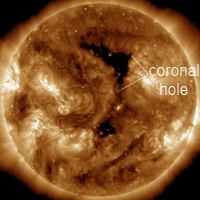
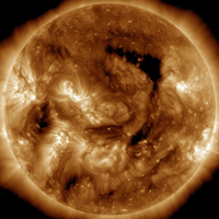
The question I would like to ask is regarding historical data. If we are monitoring corona solar storms more precisely with modern technology does that mean that the Sun is going through unprecedented activity in this era. I wonder if the Sun has been active in previous decades to such a degree, if not then is it any wonder our planet is going through so much change especially at the Polar regions.
On 06 Sep 2013, Rob wrote:
Atlantic Hurricane development.http://www.nhc.noaa.gov/gtwo_atl.shtml
On 06 Sep 2013, Bill smithN E Wales 45 d sub wrote:
Currently in Inverness area. Yesterday was a transition day from summer here,replacing the warm southerly breezes with a light westerly ,still pleasant and sunny though17 c.After a cold night ( local radio reports 1c in some glens) , and a non descript morning followed by light shower this afternoon, there has been an increasingly stiff NE wind with the temp only 12 c at 1600hrsbut feeling much colder. A thick sweater required for the first time this week. I might even light the log fire tonight,always a plus side!
On 06 Sep 2013, Steve,Dorset,UK wrote:
My favourite site for sunspots and much more on one site is this Link.... Enjoy.
http://www.spaceweather.com/
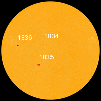
On 06 Sep 2013, Piers_Corbyn (twitter) WA Forecaster wrote:
SUNSPOT COUNTS - SUE YES This, cycle 24, peak is very low - about 67 max = 6th lowest in last 28 cycles and in view of enquiries we now have links at top of this blog on this and other matters. On choices of counts use SIDC (Solar Influences Data Analysis Center), I suggest, but there are many around and beware of 'revised' data sets. CO2 Warmists often meddle in solar discussions purely to confuse. Sunspot counts as such do NOT directly relate well to Earth temperatures in general except for smoothed ODD cycles. Note we are in an even cycle, which are generally cooler Earth temps than ODD cycles even if active. The main earth temperature signal is 22yrs while solar activity is 11yr. See LAST COMM, No 29, on http://climaterealists.com/index.php?id=3307&page=2 . We pointed this out in the Russian Academy of Sciences 2004 and I notice some have 're-discovered' it and related geomagnetic matters recently.
On 06 Sep 2013, Norman-Hereford, Bargain sub. wrote:
Sue, and anybody will find the facts and dicussion of sunspots, useful on this site: http://www.landscheidt.info/?q=node/50
I find the comparison of current measurment methods vs the older count values informative.
On 06 Sep 2013, Sue wrote:
Morning Piers, so many different figures floating about on the web when I search i thought you'd be the man to ask, what is the official sunspot count for cycle 24 so far? And is it unusually low this time in comparison to previous cycles? So much info out there it's hard to get a clear answer.
On 06 Sep 2013, Saskia Steinhorst (part-time sub. Neth.) wrote:
Beautiful and somewhat eerie display last night! At 1 AM a totally clear and starry sky - Milky Way and all - with the exception of a small patch of sky directly over one of the Wadden-islands (Ameland). Continuous flashes ranging from bright white to deep orange. Almost like science fiction ;-)
On 05 Sep 2013, Paddy (Aberdeen south, 130m elevation, sub)) wrote:
Big change, overcast until 4.30pm when the cold front had cleared eastwards, overnight temp 13˚C, rising only to 15˚, then up to 17˚ once the sun had come out, slight winds starting out NW then turning NE & E, very different feel, had to say goodbye to shorts & tee shirt & put on an other layer, 8˚ by 10pm. Still plenty of swallows around, also butterflies when the sun comes out, saw an admiral this afternoon. Ground very dry, river Dee has been low for many months now. MO computerised forecast has been all over shop last two days, promising heavy rain, light rain, no rain in the run-up to this morning. Piers might not be right in terms of day and exact geographical area but broad brush almost always on the nail, MO mostly only useful in the immediate term.
On 05 Sep 2013, Rob wrote:
There has been some debate amongst posters lately as to when autumn starts. I would say that seeing we have now had our first rush hour multiple vehicle pile up caused by fog then autumn is definitely here. Also MO forecasting overnight lows of 0 - 3c in NW Scotland, certainly autumnal.
On 05 Sep 2013, Rhys Jaggar (30d annual subscriber) wrote:
Gill
i"ve seen with several of my tomato plants this year that just as what would be a normal crop has been harvested a second wave have emerged in the past 10 days and are growing on. Time will tell whether they will have long enough to generate ripe fruit, but chutney awaits if not. Mostly its happening on strains I bought as the insurance for a dodgy summer (Glacier, Sub Arctic Plenty, Black Krim) but in one case it's almost another 100 fruit!! I've harvested nearly 100 already and suddenly I've got a second wave coming along. There I was thinking the fruit set hadn't happened. It was just that they waited for the first wave to ripen before setting off.
On 05 Sep 2013, John Planet wrote:
Clive. The latest chart the BBC have shown today is the rain stating south in a line heading north through tomorrow missing the south west of the country. Saturday has the rain mainly in north western England and north Wales with the direction of the low moving north west. Things could change though with the low taking a more north direction which means that the rain could then centre over the north and north east of England instead. We would have to wait and see what happens?
On 05 Sep 2013, shaun wrote:
http://solarscience.msfc.nasa.gov/predict.shtml
I usually like to check this link on the 1st of every month to see Nasa's update, but they are 5 days late. Anyone know where else I could get similar information?
Also, I wonder why they haven't update it, they're usually consistent.
On 05 Sep 2013, Russ NE Derbyshire subs wrote:
Several people mentioning brambles. They've done terribly down these parts. Paths which are usually overgrown by the 3rd week of July are still struggling to show much growth at all. Some 10 to 20% of normal growth. Maybe the late snow and ice messed up their growing pattern somehow, but the fern is like 'Jurassic Park' sized and the sheltered Rowans are drooping with fruit. Small trickling streams are still trickling, adjacent to farmland, and there's plenty of swampy bog around as my boots found out yesterday. The local farmer who had big problems has now reverted to sheep grazing on his biggest field, the one which started out as barley which drowned, replaced by oil-seed rape which baked to death, so the land is back to grazing land, which it has been for decades. Some of his barley in other fields is very grey and has been left but he has harvested some, so hopefully won't have lost everything this year. His neighbours had fine crops but planted later so missed the snow & floods..
On 05 Sep 2013, Saskia Steinhorst (part-time sub. Neth.) wrote:
Drought in our parts is so severe that soccer clubs are now diverted to other sport fields because the ground is too hard. In other parts of the country natural water sources are completely dried up, devastating and decimating the local flora and fauna.
On 04 Sep 2013, Clive wrote:
The met office is predicting a low pressure for Friday and Saturday that seems to come out of nowhere. I can't see it on the chart now which seems to give me an element of doubt about it. I am wondering whether they will get it wrong for the weekend. The low pressure is supposed to move northwestwards but everything at the moment is moving eastwards including the cold front tomorrow. What would happen if this cold front were to carry on eastwards and the high pressure from the west was to move in during the weekend.
On 04 Sep 2013, Paddy (Aberdeen south, 130m elevation, sub)) wrote:
Cooler day today, more cloud & less sunshine, overnight min temp 11˚C, rose to 21˚ max, back down to 13˚ by 9pm. Good SW breeze, waiting now for the change to NW tomorrow and much cooler temps, could do with a bit of rain. Farmers here v busy combining & baling, heard that barley has too much nitrogen for malting on account of the dry conditions this summer. - Gill, we've given up on tomatoes after last year, too much work for mediocre results, especially in the last few summers; though this year would have been good if we'd bothered. We have too much else going on as well to make a proper job of them and they always taste a bit floury, and we live many hundreds of miles north of you. Climbing French beans have been excellent in the tunnel, always a winner when the right variety is grown. We'll have plenty brambles by the looks of it, rasps have been brilliant and still going.
On 04 Sep 2013, Bill smithNE Wales (45 d sub ) wrote:
Cuurently on hol in Inverness area. Last 2 days have been sunny dry and warm 22c strong breeze at times. Spectacular alto cumulus lenticularus this afternoon around the Cromarty Firth.Winds died down this evening although skies are still clear, awaiting the cold front to push through later tonight. All in all fairly good correlation with your forecast for first 4 days . I see the Met Office have issued a yellow warning for Friday Saturday for rain, pretty much in line with your forecast "intensely thundery low" for the same period.
On 04 Sep 2013, Michael wrote:
Yamanashi Japan!
Well time for another update from the land of the rising sun, which this year Japan has lived up to that name in these parts.
After mostly continuous dry today we had rain followed by a huge thunderstorm tonight, and loads and loads of rain, finally!
We also got a fairly strong earthquake which gave our house a good shaking this morning.
There have been some tornadoes hit Japan this week doing damage.
Recently tornadoes here are increasing in a country that usually don't get any.
This summer has been a mix of heavy rain often in some areas to no rain at all in other parts.
It is finally cooling a bit now, which is good.
I am looking forward to this winter, I expect it to be very very cold and very snowy in some parts of Japan if my predictions are correct!
On 04 Sep 2013, Steve Devine (Sub) Waltham Abbey wrote:
Have to agree with you Gill 1066, especially the last part. I had barely over 5 hours sleep last night from the sheer humidity and lack of breeze circulating around the first floor of our house. Have to commute through London on the underground which will be unbearable tonight and tomorrow evening especially. Cannot wait for some rain / storms to break through. MetO have issued warnings but not for SE England strangely (the models show heavy/torrential rain pummelling SE Eng Friday, switching to SW Eng/Wales/Mids Sat-Sun).
Give me early February and a foot of snow any day! Making a snowman in the garden, watching fat flakes fall from the sky on a gentle NE'ly breeze. Yummy.
On 04 Sep 2013, Gill 1066 East Sussex - subscriber wrote:
I've been saying for some time now - we moved onto late summer and not autumn. Glorious day again here. Birds and butterflies taking advantage of the halcyon days of summer. We would have loads of blackberries too if my son hadn't gone hedge cutting so early! However change is imminent according to mobeeb and Piers. Time to put the pool to bed (which I am today) and preparing the garden for the rains to come. I still have small tomatoes growing on in the tunnel Paddy. If the temp holds inside they may grow all the way till the end of he month. But the sun is much weaker now - little strength after 5.30pm. Sadly for me autumn is waiting around the corner; but for all you weather watchers who can't wait for those autumn storms and snow, I bet you're all champing at the bit with anticipation.
On 04 Sep 2013, Saskia Steinhorst (part-time sub. Neth.) wrote:
This 'to and fro' with regard to temps is remarkable! It felt positively chilly the past week, especially during mornings and evenings, but walking the dog last night at 1 AM it was actually warm enough to just wear a t-shirt. With Piers forecast for Sept for our region it seems we're in for some unusual Fall weather this month. Our blackberry bushes are laden with fruit and provide me with ample supply for making many jars of jam. IWith regard to bees and/or bumblies, I hardly see any activity at the moment. They seem to have all but disappeared.
On 04 Sep 2013, John B wrote:
Piers, a lot for earthquake activity today (4th Sept). So far 5 earthquakes ranging from mag 5.9 to 6.5. Details can be found on the USGS website http://earthquake.usgs.gov/earthquakes/map. Not sure if this covers a QV4 or QV5 period.
On 04 Sep 2013, Russ 45day Derbyshire subs wrote:
Paddy yes, a lady puts a few hives at the edge of the heather moor, but this year didn't set them up until the last 3 weeks of August. I can only imagine that she set them up elsewhere, but they weren't doing too well so moved them back to the position she has had them for the past few years..... Theo, that's interesting thanks..... Glorious summer to autumn and back again in just a few days. This is one strange roller-coaster ride of a summer...or is it autumn?? Should be a bumper crop for the farmers. Not heard any whinging from the water companies yet? Exposed Rowans are 50% fruit but well sheltered ones are laden. Vast numbers of midges on the moorland fern which is unusual for these parts.
On 03 Sep 2013, Paddy (Aberdeen south, 130m elevation, sub)) wrote:
I could just copy and paste what I wrote yesterday: we got up to 26˚C again today, from an overnight low of 14˚, now at 9pm it is still 15˚. It felt hotter at times because the NW breeze was not as strong as yesterday. - Russ, after a quick perusal of a Collins field guide there appear to be quite a number of bee species in Britain but only one is called honey bee, so it is more likely that what you saw is another bee species though perhaps there are beekeepers who put their hives on the moors for the heather? Certainly done here. - Saskia, we have so far had very few days where one could feel a cold undertow, like we had for a long time after the late spring, which is really surprising for our part of the world. Snow was predicted on the highest mountains of Scotland on Saturday, which would be in line with Piers' predictions, but I have no way of knowing whether it actually happened, not time to find records.
On 03 Sep 2013, Theo Stamford wrote:
@ Russ NE Derbyshire re bees.
If they were honey bees, you were right the first time - they operate at about 34 degreesC, which they maintain in the hive and when flying, but when it is cold they can go on shut down and can't move. If they leave the nice warm hive to return to a source they were plugging the day before and it is colder than before they get caught out, land to collect nectar and cool down to much. At ten degrees they become immobile. Burying their heads is what they were doing. They don't make it home if it they are stuck out too long when cool and they run out of fuel. This variable temperature weather is a big problem for them.
Having said that, some pollen is like dope to bumble bees in particular e.g. dahlias. In any weather you'll see 4 in one flower head, more stoned than Withnail on a Camberwell Carrot.
On 03 Sep 2013, Andy B 45 d sub S.Wales wrote:
Piers here is an article on the effective badger cull in Ireland http://www.fwi.co.uk/articles/03/09/2013/140872/irish-bovine-tb-drop-attributed-to-badger-cull.htm
be careful not to upset your farming customers!
On 03 Sep 2013, Saskia Steinhorst (part-time sub. Neth.) wrote:
[cont.] - There is, of course, the question of what causes the increase or decrease in solar activity?! Is it an internal 'solar engine' so to speak, or is this star itself also influenced by yet another outside force? Hm.
On 03 Sep 2013, Saskia Steinhorst (part-time sub. Neth.) wrote:
@Paddy - It's striking, the contrast with regard to Nature this year, being either "too early" or "too late". Although the late broods would make perfect sense in as far as 'making up' for lost broods during the cold Spring. Autumn is here as well. Humidity has increased, the 'feel of the air' is colder despite similar temps. @Russ - I guess I understood everything EXCEPT the lag period. Really, 800 years? I'll do some more reading-up on the matter. There's a Dutch geo-scientist named Bas van Geel who has been linking solar activity and temps ever since the Nineties. Here's an article by him from 2012: https://tinyurl.com/c26tspx According to Van Geel, reduced solar activity and the result thereof can be measured by deposits of both carbon-14 and beryllium-10, isotopes formed by space radiation. In periods with reduced solar activity, and hence less solar wind, these isotopes find it easier to reach earth. And finally [cont.]
On 03 Sep 2013, Gerry N Downs 600ft 45d wrote:
Piers, what passes for the technical magazine of my engineering institution - more like a Guardian supplement than a learned publication - has been full of warmist propaganda in the run up to the release of the AR5 summary. Although i usually skip most articles on climate change, I did study the one on a report by Paul Williams on increasing air turbulence. The main premise of the report was that warming of the atmosphere 10km above the equator is causing the speed of the jet stream to increase. Do you agree with this? From what I have read this hotspot theory was disproven as long ago as 2006 with sonde balloon data.
On 03 Sep 2013, Russ NE Derbyshire subs wrote:
Paddy, not Bumbles but small Honey Bees. So this is perfectly normal. Good to know. ..... Noticed yesterday that loads of leaves have been blown off the trees. Very grey, certainly dead and adding to the autumnal feel. Ankle deep in places, more like the first week of October. The cold had been swapped for hazy sun and humid warmth. If it would stay the same temperature for more than 2 days on the trot I'd know whether or not to take a fleece. I hate carting something around when it's not needed.
On 02 Sep 2013, Paddy (Aberdeen south, 130m elevation, sub)) wrote:
Autumn, what autumn? Today at 7.30 it was already 18˚C and by midday it climbed up to 26˚. The thermometer is at the back of a tunnel in the shade and was exposed to the occasionally stiff but mild NW breeze. At this time of year we have to work in our polytunnels where it was quite likely around 30˚ if not more, and that's with all the doors & side curtains open, phew!. Lovely sky again, quite a few lenticular clouds, still 18˚ at 9.30pm, quite something for Aberdeenshire, I agree, Bill. - Great sunset photos, Craig. Are you open to posting other folks' photos now? - Russ, I wonder whether that wasn't bumble bees you saw? Many of them begin to peg out at this time of year & can be found hanging on flowers like that, whereas bees would fly back to their hive if they wanted shelter.
On 02 Sep 2013, Bill smith ( NE Wales 45 d sub ) wrote:
Currently in Inverness area on hol. Summer birds eg swifts still here darting over field and lochan.Our host , a f armer reports it's been super summer this year, hard ,to believe after such a stark contrast last April when I was here and saw lochan flooded and a snow line at 2-300m
Very windy overnight but mild and dry. Today spent a beautiful day over in "home country" ,Aberdeenshire, 22 c sunny, but breezy, most refreshing on a walk. It felt very much like a good late summer day today.
On 02 Sep 2013, Steve,Dorset,UK wrote:
Thought that you all would like to have a look at this Video about climate as seen by the 50 to 1 Project..... Via WUWT.
http://wattsupwiththat.com/2013/09/01/my-50-to-1-project-interview-is-now-online-along-with-the-main-video/#more-92941
On 02 Sep 2013, Piers_Corbyn (twitter) WA Forecaster wrote:
CITIZENS. Great Comms! The message of these last 7 Comms is that for Brit+Ire+N Atlantic + Eu + USA (see Quadzat above!) + S hemisphere, ie World there are dramatic contrasts - and sharp storms (from R5) - not your benign low contrasty boring normal September weather; basically a signature of wild waving Jet Stream - LIA/MIA regime weather (and I suspect, related, extra sensitive to solar events polar regions). === CRAIG M on your note for R5 thanks v much I posted on Tall Bloke link Tim Channon too and wonder if all our R5s give Mobile Polar Highs. Your Obs that this polar air now heading into Europe is leading to warmth Britain (espec E/S), after it, IS TOPS. ALL PLEASE LOOK AT OUR NEW CET GRAPH on 30d/45d Br+Ir - and note the first 6 days are the same as in 45d CET forecast - the colder then warmer (mean CET) timing is dare I say ''spot on'. === LASTLY might I ask people to promo WA forecasts now it is start month and we have significant Br+Ir, Eu & USA advances. Thanks PC
On 02 Sep 2013, Phil Ipswich non sub wrote:
Re: seasons start. Hi Paddy. You hit the nail right on the head. It's a manmade scheme (based on solstice and equinox). So why do weather presenters feel they can come up with their own scheme? Perhaps because there are so many woman weather presenters. Oh, hush my mouth. Checking wiki it seems the Roman calendar uses the 1st of the month. Oh well, trivial case closed (I guess). We're here to discuss the weather. In the grips of winter this will seem insignificant.
On 02 Sep 2013, Steve,Dorset,UK wrote:
What a super summer we have had here in Dorset and are still having, it is a glorious sunny warm morning here wall to wall sunshine with a slight breeze.11:14 2/9/13
On 02 Sep 2013, Gill 1066 East Sussex - subscriber wrote:
Good old summer's not going down without a fight!
On 01 Sep 2013, Craig M (Berks 45d Sub) wrote:
Lorraine mentioned a warm winter in NZ. South America is at the other end of the js with disruptive snow that followed an SSW & poss record low AAO. South Africa also has been hit by winter >> http://bit.ly/17APMMm << Antarctic ice continues to break records >> http://bit.ly/14jh4Rm <<
note the MSM silence as they focus on Arctic ice==>>This BBC report said 'cooler than average conditions have prevailed [summer 2013]' deliberately not mentioning record* cold air temps in the Arctic this year (*only since1958 though lots of records during LIA note wax/waning of ice) >> http://bit.ly/13Tgx0 << if it had been record max would the BBC have said 'warmer than average'? Not a chance. They are just being more cautious with their approach due to pressure as the reality begins to overehelm them. What they leave out is more telling.
On 01 Sep 2013, Paddy (Aberdeen south, 130m elevation, sub)) wrote:
Overnight temp 8˚C, grey start, overcast with stratus and NW breeze which picked up considerably in the afternoon for about 4 hours, interesting skies with many different cloud types, the sun broke through increasing gaps in the cloud around 4.30pm and it got to 18˚C by that time, 15˚ by 9.30pm. Saw a lot of swallows again at various assembly points on our Sunday walk, often see some passing over the farm on their way south. - Phil, the start of the seasons is on the 21st only in the manmade scheme of things, doesn't mean that the seasons actually start on that date, look at the spring just past.
On 01 Sep 2013, Russ NE Derbyshire subs wrote:
Blimey! It was very cold today walking the dog on the moors. We saw dozens of bees clutching onto thistle flowers, burying their heads deep in the flowers as if they were trying to escape the cold. The thistle petals forming a shape around the bees and acting like a wind deflector. Every thistle plant we saw had a few bees, apparently sleeping, so there must have been hundreds all doing the same thing. The first time I've witnessed this. Hundreds of finches flocking too and a fantastic sunset.
On 01 Sep 2013, Craig M (Berks 45d Sub) wrote:
Remarkable Piers...an outbreak of polar air that pushed down into lower latitudes (Europe) as you predicted. Orientation has affected the leading edge but broad thrust very well predicted. Tim Channon makes some obs from Oxfordshire >> http://bit.ly/14igrrw << Polar airmass now looks to move East across the North sea in the coming days allowing warm tropical air to rise up. ==>> Some pics of an LIA like sunset I captured ahead of polar air >> http://bit.ly/17AiXzp
On 01 Sep 2013, Phil Ipswich non sub wrote:
You'd think one of the first things that a weather presenter would learn is when the seasons start. About the 21st of March, June, Sept and Dec. SO IT ISN'T AUTUMN YET. Grrrr
On 01 Sep 2013, Russ NE Derbyshire subs wrote:
The weather here in NE Derbyshire has been fine but boring. The whole country has seen wind, rain, floods, lightning, but as usual we missed all the fun. Been a bit windy and cooler over the past few days though.
On 01 Sep 2013, Richard Brown wrote:
So, winter is fast approaching and its about time we had a proper one with snow from late November through to start of March. Any chance of this?
On 01 Sep 2013, Wally wrote:
They still want it their way:
Cooler Pacific Ocean May Explain Climate Change Paradox
"The engine driving atmospheric circulation on global scales resides in the tropical Pacific," Xie told LiveScience. "When the natural cycle shifts the next time to a warmer state, we're going to see more extreme warming on the global scale."
http://www.accuweather.com/en/home-garden-articles/earth-you/cooler-pacific-ocean-may-expla-1/17201340
The detailed findings of the study were published online today (Aug. 28) in the journal Nature.
On 01 Sep 2013, Russ 45day Derbyshire subs wrote:
Saskia....you seem to have understood correctly. The oceans take a very long time to release that heat too. After the solar activity decreases, the temperature of the Earth's atmosphere remains cool, less heat is transferred to the oceans, so there is a net heat loss. When the ocean temperature reaches a low enough level the atmospheric CO2 begins to be re-absorbed. It was released as the ocean temperatures rose, when the solar activity was high. This cycle is what causes the 800 year lag between peaks in solar activity/record high temperatures, and high atmospheric CO2 levels. It takes hundreds of years for the oceans to warm up and release their CO2, which is why we are seeing CO2 levels starting to rise now, from a very low level. Plant life starts to die at an atmospheric CO2 concentration of around 150 parts per million. So 290ppm in the 19th century would enhance crop failures, I have no doubt.... >> http://bit.ly/16ZCtCD <<
On 31 Aug 2013, Paddy (Aberdeen south, 130m elevation, sub)) wrote:
Autumn is here: 6˚C at 7.30 this morning, NW breeze all day, sometimes strong, max temp 18˚, light showers after 3pm, cloudy but with good sunshine in between, 8˚ by 11pm. The radio forecast was talking about snow on Ben Nevis and Cairngorm, in line with Piers' prediction of cold, though it is altogether not as severe as in his 30d forecast and the pressure pattern is different from his Euromaps forecast, with high over Britain at the moment and the lows well off to the northwest. I think this is a challenging year needing adjustments all the time. - Swallows now gathering at the usual places prior to leave taking, again on the early side; Saskia: someone told me today that they'd had two broods on their farm, which is in a more sheltered location than ours. Rowan berries strikingly red now, willow herb seed flying around in the wind like snow flakes.
On 31 Aug 2013, Andy wrote:
The Beeb have produced some excellent comedy in the past. I believe their current stance regarding AGW is just a continuation of this tradition.
On 31 Aug 2013, Saskia Steinhorst (part-time sub. Neth.) wrote:
[cont] - Then the whole cycle starts up again when solar activity increases. The point at which the oceans have been either completely 'saturated' or 'depleted' naturally will be off by years/decades (?) compared to solar activity, which means any effect will not be immediate. And this is just a part of earth's weather cycle. Have I understood this correctly?
On 31 Aug 2013, Saskia Steinhorst (part-time sub. Neth.) wrote:
So I'm trying to follow the scientific aspect of the discussions, and naturally I get lost somewhere ... I did read an article which went a little ways towards explaining things (https://tinyurl.com/mkutje2) and sent me off into other directions to find an explanation for the PDO and in particular SLAM (Solar-Lunar Amplification Magnetic) process. Here's what I've come to understand, simply put in layman's terms: that a (large?) portion of our weather also depends on how much heat has been stored in the oceans. Yes? Come to think of it, this would seem very logical. The oceans acting like a heat-sink in a PC or the black-painted water barrels people use in greenhouses to store heat. The more solar activity, the more heat gets stored in the oceans Then the oceans slowly release that heat back into the atmosphere. If solar activity is at its lowest and this coincides with stored oceanic heat having all been released, it gets cold. [cont.]
On 31 Aug 2013, Piers_Corbyn (twitter address) wrote:
EXCELLENT STUFF GUYS - and please put in LINKS when you have good info. == WILL HARRISON, The PDO? Yes the BBC will use anything to hide the running-dog failure of the pseudo-scientific cretinism termed 'man-made global warming', but to use the PDO (Pacific Decedal Oscillation) is totally contemptible because we explained this very important world envelope weather parameter which pervades many data sets in terms of Solar-Lunar factors - back in Dec 2008 when i gave a short presentation at the 100th anniversary Dinner of HG Wells / Royal College of Science Association in the Criterion Restaurant Piccadilly London. This was well publicized at the time but the BBC never reports anything which nails their lies. I showed with graph the PDO is a beat envelope signal between The solar (MAGNETIC) Hale Cycle (~22yr) and the rotation (retreat) period of Lunar nodes (~18.6yrs) and reported this to New York Heartland Conference 2009 and the Parliamentary Cttee on Dec 2010 cold in Feb 2011
On 30 Aug 2013, Saskia Steinhorst (part-time sub. Neth.) wrote:
Very interesting article which includes graphs showing correlation between solar activity and earth temps. http://tinyurl.com/pcc2x5g
@Paddy - contrary to your observations, our swallows seem to actually have more broods this year. Today I even found a very late fledgling with "take off problems". Other birds have been producing young very late in the eyar as well, probably the result of the cold Spring.
@Russ - I have noticed leaves turning brown as well. I think both the changing winds as well as the drought have been of influence. The soil here, sea clay, is rock hard when you dig down 15 cm or so. Although potato framers are happy that their combines aren't sinking into the ground, the lack of rain has certainly wreaked devastation on other crops. I have also noticed my rose bushes turning brown and being infested by lice, much worse than previous years.
And yes, it does seem as if a weather pattern has been established these past few years. Which means we will need more wood
On 30 Aug 2013, Paddy (Aberdeen south, 130m elevation, sub)) wrote:
Interesting observation, Russ, not something I have particularly noticed around these parts, we have certainly not had the amount of wind you have had, so that would make a difference. Though today has turned out quite windy, mostly from the west, took the heat down a bit, we had 22˚C from about 10am 3pm after an overnight low of 10˚C. It got still by 6pm, as often happens, and felt really mild before a much fresher & stronger NW wind started up around 8, upturned leaves on the trees, whatever force that is. The sky was a real spectacle today, everything from summer holidays to end of world scenarios, mostly cumulus but quite a few cirrostratus & cirrocumulus in various shapes. Saw a peacock butterfly today as well as the usual tortoiseshells, they come out of hiding every time the sun shines & temperature rises for a while, where the stay in between and survive is a mystery.
On 30 Aug 2013, Steve Devine (Sub) Waltham Abbey wrote:
Very, very interesting article below about global cooling, prospects of a nasty mini ice age and the absorption of heat by the oceans, not to mention the hibernation of the sun...
"On stratosphere, is Spiegel describing the 4th component of a quadruple whammy? Already we have: 1) low solar activity, 2) a negative PDO, 3) a starting negative AMO and now 4) a dried out stratosphere that lets massive amounts of heat radiate out into space. Sounds like the potent ingredients of a nasty mini ice age."
http://notrickszone.com/2013/08/29/spiegel-scientists-hopelessly-stumped-by-present-ocean-cooling-still-insist-they-are-certain-about-the-future/
On 30 Aug 2013, Rob wrote:
Just had a look at some American hurricane prediction sites and they are looking at two possible sources at the moment . One just to the east of the Leeward Islands that they give a 30% chance of developing and another off the Africsan coast that they give a 50% chance of developing so it looks possible we will see the WA1 storm developing within the time period Piers specified
On 30 Aug 2013, Russ NE Derbyshire subs wrote:
Paddy, re:brown trees & drought. I have noticed most browning on almost all types of deciduous but not in very sheltered positions. Only on exposed slopes and invariably the west facing side. Repeated, persistent, chilly winds early morning, following relatively warm sunny afternoons is, I believe, the recipe for this phenomenon. It has affected trees on boggy moorland with streams running close by, just as badly as trees on baked dry grassland, hundreds of metres from running water.
On 30 Aug 2013, Saskia Steinhorst (part-time sub. Neth.) wrote:
Past few days the mornings have been positively chilly, despite temp indicator of +18 Celsius. Seems like the air has cooled down significantly. Afternoons, however, are still warm with temps between 20-25 Celsius. Number of geese are increasing every day, the owls seem to hunt more often, there seem to be more buzzards (Buteo buteo) than usual, all hunting as well. Stocking up? Oh yes, and I have "splurged" on a 1 month subscription 'get 3' deal. Too darn curious about this coming Fall ...
On 29 Aug 2013, Paddy (Aberdeen south, 130m elevation, sub)) wrote:
Another changeable day, less cloud than yesterday, temp at 7.30 was 10˚C, so we're going down and autumn suddenly seems just round the corner. But it still got to 24˚ when the sun could break through, I was sweltering in our veg tunnel which needed some work, though the minute the sun disappeared it felt markedly cooler. The S'ly breeze was again rather fresh than pleasantly cooling. 'Our' swallows have definitely gone. Been sowing corn salad/lambs lettuce in the tunnel, good overwinter greens that can stand the frost & snow.
On 29 Aug 2013, Gerry N Downs 600ft 45d wrote:
The global warming propaganda machine will be at full blast because of the publication of the AR5 summary next month and they have to find a way to deflect the brutal criticism it will receive this time. Knowing the draft content of the report will mean that the usual hysterical claims that the summary makes which are then shown to be lies when the report appears 3 months later will be shredded much quicker. The magazine of my so called learned institute - Institution of Engineering and Technology - is spouting warmist drivel this month. It's embarrassing that an engineering institution should be so ignorant on the subject of climate change. The magazine often reads like a Guardian technology supplement where you learn next to nothing. I found an old copy recently that was so much better before the watermelons took it over.
On 29 Aug 2013, Steve Devine (Sub) Waltham Abbey wrote:
On Arctic Sea Ice News (Twitter) this morning "Surface melt on the Greenland Ice Sheet peaked at 44% in July. Read more about this year's melt: http://bit.ly/191cpHf"
Thinking how irrelevant and misleading that was I replied "Why dont you share with everyone that arctic ice levels are above last years and Antarctic ice well above average?"
No response...meanwhile more global warming propaganda about one segment of the antarctic ice sheet splitting in the Metro. Happens on a weekly basis now. They never answer my challenging emails either. Wall of silence = fear.
On 29 Aug 2013, Rob wrote:
This from the MWIS site today. "A sharp drop in temperature for all areas over the weekend (highest summits in the Scottish Highlands only just above freezing point). "
On 29 Aug 2013, shaun wrote:
Is it me or has the Global Warming propaganda machine been busy lately?
I'm seeing so much of it acros various news sites lately.
Hope we have a brillirant winter to remind people of the fraudulent global warming.
I fear this avg summer has appeared better than it has been due to such poor summers for so many years that some folk are easily duped into thinking yes it has been unusually warm. As a lot of non weather enthusiasts I find dont remember the weather over the previous few months never mind the last 5 summers and winters
On 29 Aug 2013, Rob wrote:
Article on BBC website today where scientists claim "Scientists found that glaciers on the East Antarctic Ice Sheet (EAIS) advance and retreat in synch with changes in temperature" Well done to them for working that one out. Feature has all the usual nonsense about rising sea levels etc and quite frankly has the distinct smell of some research scientists looking for funding to pursue further this new theory that ice melts when temps rise and freezes up again when temps fall.
On 29 Aug 2013, Paddy (Aberdeen south, 130m elevation, sub)) wrote:
28.08.13 - couldn't post this last night. Overnight temp 12˚C again, the sun was out first thing but feeling much fresher this morning, MO forecast said dull all day and apart from that first morning burst and about an hour around midday they were right, the sky was well overcast with low stratocumulus but no rain to speak of. It did get to 19˚C but quickly went down to 16˚ again. The S breeze got quite strong and there was a decidedly chilly feel to it, the nice muggy weather seems to be gone. - We have the impression that our resident swallows have left, which is at least three weeks early compared to normal; they also appear to have had only one brood this year where they normally have 2 or even 3 in good long seasons. So, along with early geese arrival in Lancashire & the Netherlands what is that telling us? - Ron, I wonder whether the early discolouration of tree leaves might not also have something to do with the long drought conditions we had?
On 29 Aug 2013, Richard Pinder wrote:
Part 3: But the theory Unified Theory of Climate provides a formula for explaining the temperatures in all parts of the atmospheres of all the planets in the Solar System, including the Earth and the carbon dioxide atmospheres of Venus and Mars, and therefore this provides a calculation for a warming so small, it should and is undetectable.
On 29 Aug 2013, Richard Pinder wrote:
Part 2: But if there is no proof for CO2 warming, then either. (1) CO2 causes cooling: Have not met of debated with a scientist who believes this, however I have heard that there where scientists who believed that because cool Stars have large absorption lines, this proves cooling. (2) CO2 has no effect: Also have not met or debated with a scientist who believes this, however this is the what the BBC believes that the sceptics believe. An assumption of a Zero effect is usually acceptable in all other scientific disciplines, if there is no proof to DENY. (3) CO2 causes warming. Everyone I know, both believer, sceptic or denier, believes this, however lack of any proof means that it has been difficult to arrive at an accurate calibration of CO2 warming.
On 29 Aug 2013, Richard Pinder wrote:
There was a BBC radio program about Climate Change deniers with Joanna Haigh and Jim Al-Khalili. I think that Joanna Haigh was appointed a Professor of Atmospheric Physics because she was the only candidate that showed no doubts about what she had learned as a student. A case of the worst candidate winning. Other candidates would have had doubts based on thermodynamics, and also the recent proof of negative feedback when positive feedback is essential for the Arrhenius method of calculating the Greenhouse effect. She is the only known Atmospheric Physicist that the BBC allows air time without being called a sceptic. Jim Al-Khalili is also a well known useful idiot, that is why he is employed by the BBC. Denying that the Climate changes or Denying that CO2 causes warming the BBC is unclear on what is being denied.
On 28 Aug 2013, Russ 45day Derbyshire subs wrote:
It's been a good year for bats here Paddy. Seen more bats at dusk on our favourite moorland doggy walk than any previous year...... Streams are still flowing strongly from the moors into the reservoirs, which are still around 3/4 full. Amazing how little rain we've had over the past 6 months, but the water table was saturated last winter, and what a difference it makes. Parts of the peat bog moorland are baked dry on the surface but there are masses of boggy areas which are still standing water and squelchy bog. Grouse numbers are very high, the highest I've seen in many years. Lots of yellowing on all deciduous trees but mostly on higher ground. The wind has on occasion been very cold and possibly the leaves are suffering due to the big swings in temperature.... Piers, those blocking highs and Jet Stream loops are going to stretch your forecasting skills matey. We have a very similar situation to last winter, blocking high with Jet loops bashing into it. A totally new weather system.
On 28 Aug 2013, stephen parker subscriber wrote:
Hi piers, is your forecast for the week end and early sept still valid for the south east?
On 28 Aug 2013, Will Harrison wrote:
http://www.bbc.co.uk/news/science-environment-23854904
Another BBC article trying to explain away the flattening off world temperatures... What's your opinion on the PDO Piers?
|


 as on
as on 
 This is a twitpic - does not update


